Thursday, August 23, 2018

New Lenox, IL: Rock Island Depot

Rock Island: (3D Satellite)
Metra: (Satellite).

The Rock Island Depot was moved to preserve it because the city wanted CVS to build here.

BRHS posted
The New Lenox station as built - circa 1905.
The Blackhawk Railway Historical Society As built, this station had the agent's office in the center, behind the bay window, the passenger waiting room in the west end, and the express room in the east end. Sometime after the express business was discontinued, the station was reconfigured, with the agent's office in the west end, and the remainder of the station used as the passenger waiting room.
Pogi Americano I remember it from the early 70's ...If I remember correctly, that is Hickory Creek on the right, and the bridge is for Cedar Avenue.
Raymond Story posted
Bill Molony posted
The Chicago, Rock Island & Pacific Railroad constructed this brick depot in New Lenox to replace the original frame depot built in the 1850's.
It was apparently designed by the company's engineering staff.
The broad eaves, hipped roofs, battered base, tall narrow windows, and particularly the semi-circular attic window are reminiscent of many Richardson-designed depots of the 1880's.
This was a typical small-town combination (freight & passenger) depot designed to be staffed by just one man.
The east end of this depot contained the freight room, used to store less-than-carload freight and Railway Express Packages.
In the center was the agent's office, with the customary bay window that allowed the agent to look up and down the tracks for an approaching train without having to go outside.
The passenger waiting room was at the west end of the depot, where passengers could purchase their train tickets, check their baggage and wait for their train to arrive.
The comments contain photos from 64, 78, 80, 83, 84 and 89
Brian Weber: The original depot is attached to the grain elevator and can be seen just to the right of the depot.

Bill commented on his post
This 1873 map shows the location of the original depot in New Lenox.

Dennis DeBruler commented on Bill's post
So the "wing" on the right was built in the 1850s.

Dennis DeBruler commented on Bill's post
Another view of the old depot.

BRHS posted
The New Lenox station - 1989.

BRHS also posted photos from 1983 and 1984.


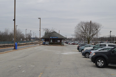
I made a point to take photos of the New Lenox depot because it is supposed to be moved since the mayor wants yet another CVS drug store on the corner.

20180326 101
View from the parking lot entrance (South) side.
 View from the parking lot (East) side.
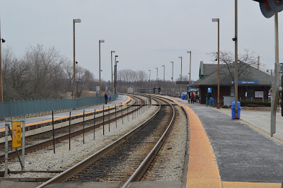
 On the platform looking eastbound (inbound).
 On the platform looking westbound.
On the platform across the tracks looking at the track (North) side from the east side.
On the far platform looking westbound. Hopefully, I'll find time to do the photos I took of the old grain elevator.
Looking at the track side from the east west side of the far platform.
 An interior shot taken from the southeast corner. The green door on the left is a bathroom. I have learned that one should not assume that a Metra station has a bathroom. That is one of the features of old depots, they do.
In the agent's desk bay looking east. This is a view that is going to disappear forever.
 In the agent's desk bay looking west.
As I go west to get photos of that grain elevator, I turn around and get the west side of the depot.
The west side from the Cedar Road crossing.
Here comes an inbound train. Note that it is left-hand running.
 It is pretty long.
 I can't remember if this is where it stopped or if it is still pulling into the station.
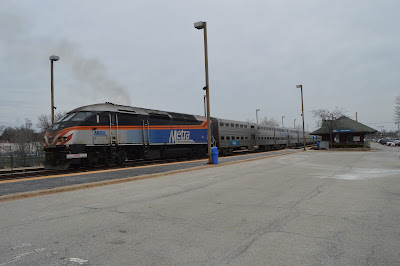
Judging by the exhaust plume, it is leaving the station. That is a rather dirty exhaust for a new looking paint scheme. I'm too lazy to research which tier of emission pollution the rebuilds are designed to meet.
There has been a long enough delay that the exhaust plume is not turbo lag.
 The locomotive is now under the Metra SWS/Wabash bridge.
It appears that newspapers haven't been totally replaced by smart phones yet.
The old freight door and the big eaves with their big brackets to help hold them up.
The big deal with commuter stations is the number of nearby parking spots. For example, Downers Grove built a parking garage as well as provide buses that serve the Main Street Station.
Remember that I observed the inbound train was running left-handed. I finally found a sign that indicated that after 3:00pm, that is during the evening rush hour, the far platform becomes the inbound platform and the near platform is for outbound trains. That is incredibly smart because access to the far platform had just two narrow pedestrian crossings in addition to the Cedar Road crossing. Note how there are stair steps to the parking lot located at every car length. So when an evening train disembarks their passengers, they can walk directly to the parking lot and then to their car.

Joseph Kelly Thompson posted
NKP 765 blasts through New Lenox, Illinois on the way to Chicago, Illinois during last year’s Joliet Rocket.
https://www.flickr.com/photos/130730314@N03/
Michael Riha Looks like you got the New Lenox depot in there... which can't be done any more.
[Michael's comment reminded me that the steam excursions ran just inbound. So this photo was taken from the east side of the Southwest Service/Wabash route. It was taken with a telephoto lens. But was it taken from the Marley Road overpass or did Joseph hike through some weeds to get this vantage point.]

Update:

William Shopotkin posed eight photos with the comment:
We  are at the new New Lenox, IL station on Metra's Rock Island District.  Opened just a few years ago (replacing a former (and now relocated) Rock  Island structure), Baroness Ann Davenport and I visited here to take  pictures of the new facility. All photos dated May 29, 2023.
Photo 1 -- View looks west. William Shapotkin photo.
Photo 2 -- View looks N/W. William Shapotkin photo.
Photo 3 -- View looks N/E. William Shapotkin photo.
Photo 4 -- View looks S/E. William Shapotkin photo.
Photo 5 -- Interior view. Baroness Ann Davenport photo.
Photo 6 -- Entrance to station. View looks north. William Shapotkin Photo.
Photo 7 -- Dedication Plaque. William Shapotkin Photo.
Photo 8 -- Conductor Welcoming passengers aboard. William Shapotkin Photo.
1

2

3

4

5

6

7

8

Dennis DeBruler commented on William's post
Google Maps doesn't show it yet, but Google Earth does. July 2022

The Google Maps image accessed June 2023 still shows the old station. I had to go back through a lot of images to find this Apr 2013 image. Google Maps is normally not ten years old.
Satellite

Robert Daly posted four photos with the comment: "New Lenox IL:  The original Rock Island station, March 23 1980 just at the end of the Rock Island's existence, and the current station serving Metra's Rock Island District trains, May 4 2025."
1

2

3

4


Youngstown, OH: Center Junction: eight railroad routes; Hazelton (CH) Tower?

(Satellite)

The bridge in some of the photos was the Center Street Viaduct.

Another reminder that a junction "tower" is sometimes just one story tall. (Update: see 'CH' Tower below for what may have been the tower. I'm still very confused by this junction.)
Bob Morley posted
I used to work in that little box shanty. It was for the Train Director at Center St. in Youngstown, OH. Back in the day, five different railroads converged on that one point. I don't know how true it is, but they say more tonnage crossed underneath the Center Street Bridge than any other points in the world. There was the B&O, P&LE, ERIE RAILROAD, PENNSYLVANIA RAILROAD and NEW YORK CENTRAL all on the east side and the PENNSYLVANIA RAILROAD, LE&E and the Y&S on the west side of the bridge.
Again it was claimed, Center Street was the only place in the country that you could receive a Red Highball. If memory serves correct, the Pennsylvania RR received its permission to move with a Red signal, the Baltimore and Ohio moved on Green, the Erie moved on White and the New York Central and the P & L E both use the same tracks and they would move on yellow.

Michael Tidrick shared
East Side Civics post
Ed Chaffee i had the pleasure of interacting with this switch shanty many times...either by waiting in a locomotive for a hi-ball signal to cross the B&O, or by walking in to the shanty to request permission to cross...pretty neat little place...
Karl Hartzell posted
Dakota Papsun shared

Jon Moody posted two photos with the comment:
Center Street Junction, Youngstown OH, then and now.
Until the 1970s, this was a place unique in the world of American railroads.  Five railroads merged and/or crossed.  Pennsylvania, B&O, Erie, New York Central, P&LE.  Railroad men of the day, like my dad, called it “Ulcer Gulch”.
The bottom photo shows the same location today.  (Seen from the opposite direction.)
A simple crossing of the CSX and NS
Gregory Lund: I believe the pics are in opposite directions. Original pic is looking south toward Haselton Yard (train in distance to center-right) which was PRR to Conway, NYC/PLE (Gateway yard) was to center left in distance, B&O crossed directly in front of "tower"/switchtender cabin, photog standing on B&O, left to New Castle, behind photog to Akron/Willard/Chicago. In the newer pic, train is on B&O headed toward New Castle, new connection is above 2nd unit (for trains coming south on Y'town line from Ashtabula to go east on B&O to New Castle). Y'town Line to Ashtabula is straight ahead, Haselton Yard behind Photographer.
Jon Moody: Gregory Lund I agree. Same location; camera pointed the other way.
Dan Carter: Wouldn't Griffith, IN in the old days be equal with the Erie, C&O, MC(NYC), EJ&E. and GTW all xing?
Vaughn Brothers: Outlawed there a few times.
Chuck McAbee: Worked the B&O Train Order Operator's position at Haselton in 1967-68 off the Extra List. All railroads had a Statutory Stop for the Center Street Crossings. The Train Director (a trainman) would flag each carriers trains over the crossing by use of colored hand signals - flags by day and lights by night. Each carrier had a different color to respond to. The wild card to the entire operation was the EIRE and their hot bottle trains. The ERIE bottle runs originated from a mill behind Haselton Tower and through a sets of hand throw crossovers moved to the tracks farthest from the tower which was the ERIE line to Warren and Cleveland. The ERIE did not have to ask for permission to cross - they just started throwing the crossovers.
1

2

Jon Moody commented on his post
After I left the railroad I became an engineering draftsman and graphic artist. A few years ago I drew, from memory, this diagram (not to scale) of the 5 major railroads going thru Youngstown in the 1960s.
Can anyone verify its accuracy?
[Some comments verify it as accurate.]

Vinny Badagliacca commented on Jon's post, cropped, at Facebook resolution
Here is a signal blueprint for the Los Angeles River corridor from 1991- when the metrolink project began. 5 different railroads there. Railroading at its complicated best. If you could believe Santa Fe Mission tower, upstairs were the operators with the Armstrong levers, and downstairs were a gazillion old wabco and Westinghouse relays clicking picking up and dropping heels and fronts away at a million mph. Only a signalman would know what I'm talking about. The forgotten part of old railroading. Today it's all computerized.

Or was this the tower for Center Junction?

Darren Reynolds posted three photos with the comment: "B&Os 'CH' tower (Haselton) Youngstown, Ohio."
Ronald Slivka: CDid it actually control the switches? I remember some of the old heads talking about the Erie stealing switches.
Michael Morley: Ronald Slivka I think it was just a train order station; the Center Street diamonds weren't interlocked and the switches there were hand-throws.
Chuck McAbee: Haselton was not an interlocking. All crossovers were hand throw - within an area of Statutory Stops for all carriers. ERIE was the prior rights carrier at the location - as such, they could open up the crossovers for their movements whenever the track was clear of moving trains.
1
"CH" tower had no interlocking..it had a train Director but I'm not sure how it works?
Photo by: David P.Oroszi May 30,1976

2
You just see "CH" tower but big Eng-6204 is right in Front. 
May19,1936
Photo by: RCL

3
Nature's taking it back. "CH" tower now closed.
Photo by: Bob Allen ( no date)
All images from North American interlockings States A to Z and Canada..
Photo by: Unknown & no date

1953 Campbell and Youngstown Quads @ 24,000

Friday, August 17, 2018

Detroit, MI: Belt Line Junction: CRSA/MC vs. CN/GTW

(Satellite)
The is a significant rewrite because the original Aug 2018 version was wrong because the 2005 SPV Map labelled the Forest Lawn Junction as Belt Line Junction. Peter explains that the Belt Junction was much closer to the Milwaukee Junction.

Charles Geletzke Jr. posted
NYC-PC-CR Belt Line Jct. tower in Detroit, Michigan on March 21, 1978.  This tower controlled a crossing of the GTW's Mount Clemens Subdivision. (C. H. Geletzke, Jr. photo)
Tim Shanahan shared
A Charles Geletzke Jr Photograph
Charles Geletzke Jr. also posted

Wayne Koch posted
Peter Dudley: Belt Line Junction is located on Detroit's east side, just north of the Dodge Main site (today's GM / Cadillac Assembly "Poletown" plant).
The Michigan Central / New York Central Detroit Belt Line diverged from the M.C.R.R. / NYC Bay City Division, and crossed the parallel Grand Trunk tracks here. The tower is long-gone.
The Belt Line once extended all the way to Detroit's east riverfront, connecting with Detroit Transit Railroad (another M.C.R.R. / NYC line). Today, the line ends just north of Gratiot Avenue (where a M.C.R.R. freight station once stood). It served many factories, including Packard Motor Car Company's plant (1906-1956).
Peter Dudley shared
Nhat Quan V. Do What intersection was this tower closest to?
Peter Dudley The tower must have been located east of St. Aubin (within shouting distance of Milwaukee Junction), and west of Joseph Campau. The area has changed, as a result of Poletown plant construction (Hamtramck Drive is new -- the Belt Line no longer directly connects with the North Yard Branch at the former - tower site).
http://www.michiganrailroads.com/.../2149-belt-line...
For some unexplained reason, these "Belt Line Jct." tower photographs don't match. Did a brick tower replace the frame tower, at some point?
Nhat Quan V. Do Is it (apprx.) here? https://www.google.com/.../data=!3m6!1e1!3m4!1sD-o...

Peter Dudley commented on his share
The attached Google street view looks east from the "intersection" of St. Aubin Street and Clay Avenue -- Belt Line Junction Tower would have been visible from here (Google coordinates 42.381237, -83.055914).
The track crossing over Hamtramck Drive on the CN overpass (visible in the distance) no longer connects with ANY of the High Line tracks (foreground).
Dennis DeBruler commented on Peter's share
While checking out the location of this junction, I discovered another roundhouse. Was this GTW?
1940 Highland Park Quadrangle @ 1:24,000

Dennis DeBruler commented on Peter's share
You can still see part of the foundation of the west wall. And I think the big green glob is in the turntable pit.
https://www.google.com/.../@42.3787593,-83.../data=!3m1!1e3

Peter Dudley commented on Dennis' comment
That was Milwaukee Junction Roundhouse -- the entire footprint of this structure is almost-traceable in current Google satellite views.
The labels in the attached Google satellite view were applied by yours truly (Peter Dudley). The "Milwaukee Junction Depot" label refers to the depot's original location, which may have been built when Grand Trunk Railway of Canada (GTR) acquired Great Western Railway of Canada (GWR) in 1882. Later, the depot was re-located farther south, along the Holly Subdivision's west edge.
GTR's original Detroit-area "Engine House" was completed c. 1859, north of "Grand Trunk Junction" (re-named West Detroit in 1887) -- the approximate Google coordinates are 42.329524,-83.104776. This rectangular structure included an enclosed turntable.
I'm still looking for information about the roundhouse and depot at Milwaukee Junction, and the "Grand Trunk Passenger Station" (1859 - 1907?) at West Detroit.

Charles Geletzke Jr. posted
NYC's (PC-CR) Belt line Jct. in Detroit, Michigan on March 21, 1978.  Here we see the NYC's line crossing six tracks of the GTW to get back to their own Bay City Branch just south of North Yard. (C. H. Geletzke, Jr. photo)

Wednesday, August 15, 2018

Battle Creek, MI: 1887 NYC/MC Depot and Hinman Yard

Depot: (3D Satellite)
Yard: (Satellite? My guess based on this post.)

Jim Arvites posted
Postcard view of a passenger train making a stop at the Michigan Central (NYC) station in Battle Creek, Michigan in the early 1900's. The depot was opened in 1888 and is still standing today.

Benjamin Gravel posted five images with the comment:
Designed by Rogers & MacFarlane. Michigan Central Railroad Passenger Depot, 44 McCamly Street built in 1888 Battle Creek, MI.
1) Image of the depot from Wikipedia, date unknown.
2) Image of the depot from Clara's on the River's website, date unknown.
3) Image of the depot from Wikipedia, date unknown.
4) A rendering of the depot from an 1889 issue of The Engineer & Building Record.
5) A rendering of the depot from an 1887 issue of Engineering News.
Currently: Commercial space
Jim Kelling shared with the comment: "Michigan Central station in Battle Creek, Michigan (1887)."
1

2

3

4

5

Tim Shanahan posted three images with the comment: "Battle creek."
1
Kurt Thornton posted
This 1860's photo shows the first Michigan Central passenger station on Monroe Street (located near the present Kellogg House, on the grounds of the WK Kellogg Foundation.
Check out the big wheeled bicycle.

2

3

Kurt Thornton posted
On June 27, 1888, this Michigan Central Station opened. It's beauty showed Battle Creek's progress as a railroad destination.

Kurt Thornton posted
This late 1800's view of the Michigan Central Railroad station shows it's proximity to the BC River.

Baltimore Chapter, National Railway Historical Society posted
Jim Kelling shared
Battle Creek, Michigan (Michigan Central station)
It’s now a restaurant with an outdoor terrace where the tracks were
 
Charles Geletzke Jr. posted
NYC Train 355 with the 4051 & 40__ at Battle Creek, Michigan on August 31, 1967. (C. H. Geletzke, Jr. photo)

The MC route now shares the GTW route through Battle Creek, so the tracks by the depot are gone.
1947 Battle Creek Quadrangle @ 1:24,000

But the depot has been repurposed.
Street View

Marty Bernard posted two photos with the comment: "2 of Michigan Central's Battle Creek, MI Outstanding Depot, Duane Hall photos, May 1985."
1

2

Dennis DeBruler commented on Marty's post
The tracks became a trail and the depot has been repurposed.
42°19'16.2"N 85°10'53.8"W

Julie Kerwin posted two images with the comment: "My early photos of Michigan Central Depot from early 1900s. Now known as Clara's restaurant."
Tim Shanahan shared
1

2

Douglas Houston commented on Julie's second image
Panoramic view of the downtown with the depot to the far left side.

Douglas Houston commented on Julie's second image

Douglas Houston commented on Julie's second image

Douglas Houston commented on Julie's second image

Douglas Houston commented on Julie's second image

Douglas Houston commented on Julie's second image

Douglas Houston commented on Julie's second image


Tuesday, August 14, 2018

Wanatah, IN: Monon Depot and Junction Tower: Monon vs. CFW&E/CSX/Pennsy

(Satellite)
John Eagan posted
 found this postcard of a lake in Wanatah, IN and it shows the PRR tower at the crossing with the Monon...that's the Monon's depot with a car on the interchange track. The lake is a problem since you could not find it today: the dam was removed and the lake drained. The now "undammed" creek still runs through the area that today is a park with an old relocated bridge.
Peter ZimmermannPeter and 1 other manage the membership, moderators, settings, and posts for Ghost Railroads of the midwest, west and south. Monon abandoned in 1980 by SBD.
John Eagan At one time the 4th longest tangent track in the world from Michigan City to Battleground.

1972 Flickrs: trackside of depot, L&N dropping hopper on interchange track