This is the coal mine that had a remarkable number of Tully Monster fossils.
 |
| Roger Kujawa posted MARION EXCAVATOR TYPE 360, Pit #2 Northern Illinois Coal Co. Wilmington, Illinois Nick Koba Jr. in the back ground a Marion 5480 shovel - the loading shovel is a Marion 37 , not sure about the locomotive as they had 4 of these from 2 different companies. Nick Koba Jr. they opened Pit No. 2 in 1928 sometime. Dennis DeBruler Thanks for the date. It was key in determining the index of this mine because the Illinois records don't show pit numbers. Mine Index 359 Peabody Coal Company, Northern Mine Type: Surface Total mined-out acreage shown: 13,840 The area shown is larger than expected for the reported tonnage. It is likely that some unmined areas are shown as mined that have been disturbed but not mined. Northern Illinois Coal Corporation Northern 1928-1956 31,138,769 Peabody Coal Company Northern 1957-1974 12,885,835 44,024,604 *** *** The production for each county was not always reported separately. In Grundy County, 3,476,341 tons were mined. 31,986,845 tons were mined in Will County. 4,525,991 tons were reported mined in Kankakee County. This leaves 4,035,427 tons for which the county has not been indicated. Mining ended in Grundy County in 1972 and 1973 in Kankakee County. Last reported production: 1974 https://www.isgs.illinois.edu/.../mines-directory-will.pdf Nick Koba Jr. the 44 million tons is what they shipped out , the were mining at time anywhere from 2 to 4 different pits at the same time and from the 3 different counties and did not record or keep track of what came from each pit or county , plus they were mining 2 different coal seams the No. 2 & No.4 and in the north of the area mined the No. 1 coal seam at 2 different pits Part of pit No. 9 and pit No. 10, this could be why there is a difference in the tonnages. Kevan Davis locomotive is a porter - http://www.northeast.railfan.net/diesel112.html Nick Koba Jr. the mine also had 2 Davenport Locomotives and 5 steam locomotives. Kevan Davis https://www.nytimes.com/.../northern-illinois-coal-mine... [paycount and paywall] [Headline of Sep 14, 1974, article is: "Northern Illinois Coal Mine Is Closed After 49 Years." "The mine had been producing 2,000 to 3,000 tons of coal daily and at its peak employed 486 workers."] Nick Koba Jr. a very sad day , there was enough land left to mine for 15 more years and Peabody own more coal rights just south of Morris , Illinois just about 10 miles west of this mine. Rick Corneglio I grew up in South Wilmington, a little over a mile from the last cut. I was about 11 when the mine closed. John Eagan I remember as a kid going to the Wilmington Sportsman Club and seeing the top of a dragline crane working over the top of the spoil hills. |
 |
| Nick Koba Jr. responded to my request for a map of the pits in Roger's post |
 |
| Nick Koba Jr. commented on Roger's post Here is the sister photo of Pit no. 2 |
 |
| Roger Kujawa posted Wilmington Will County Illinois Real Photo Coal Mining Postcards Nicholas S Koba Jr.: A Marion 360 drag , a marion 5480 shovel , a Marion 490 loading shovel. The Northern Illinois coal mine where i worked from 1967 till 1974 when the mine closed. |
Josh Biggers posted the comment: "Question, does anyone have any photos of the strip mines near Coal City, IL? My great grandfather was a dragline operator there in the 40s and 50s."
Nick Koba Jr. posted the following three comments:
 |
| 1 this mine started out as the Northern Illinois Coal Corporation , the mine was first called the Wilmingtom #10 Mine . this was an offshoot of the Sunlight Coal Corporation of Indiana . the stripmine started up in 1927 and ran 47 years till 1974 , 10 men lost their lives at the mine during those years .they mined about 14,000 acres and shipped over 44million tons of coal during that time and during the 1930's to 1950 employed over 475 miners . the first machine was a Marion 360 dragline . |
 |
| 2 the next dragline was a Marion 5480 . |
 |
| 3, cropped and the in the 1940s they got 3 Marion 7800 draglines he could have operated any of these or even all 3 types . |
In this satellite image, note all of the long, skinny lakes that are close to each other. Those are the tattoos for a lot of strip mining.
Mine Index 359
Peabody Coal Company, Northern MineType: Surface Total mined-out acreage shown: 13,840 The area shown is larger than expected for
the reported tonnage. It is likely that some unmined areas are shown as mined that have been disturbed
but not mined.SHAFT, SLOPE, DRIFT or TIPPLE LOCATIONSType County Township-Range Section Quarters-Footage
Tipple * Kankakee 31N 9E 6 SW NW SE
Tipple * Will 33N 9E 29 SE SW SE
* Mining occurred in Kankakee, Will and Grundy Counties. This mine is atypical in having separate index numbers in
the different counties. The early (three-digit) mine index numbers were assigned for chemical analyses and sample
sets in other databases, thus it would be imprudent to change the numbers to make them more consistent in this
database of mine names, owners and years of production. Mine index 834 is the same mine in Kankakee County,
mine index 675 is the same in Grundy County, and in Will County, the mine index is 359.GEOLOGY
Houchin Creek ** 52 1.71 3.42 Surface
** Most pits mined the Colchester Coal. The Houchin Creek and Cardiff Coals were mined only where those seams
were thick enough, generally in the southern and eastern parts of the mine.
Geologic Problems Reported: The overlying drift was a hard, gray, boulder-filled clay, and below that, in Will County,
up to 20 feet of massive gray shale (Francis Creek). The Colchester Coal was relatively flat-lying, while the Cardiff
Coal dipped markedly where the Francis Creek Shale (overlies Colchester Coal) thinned rapidly. The bottom 5 feet of
the Francis Creek Shale contained coal balls and siderite nodules up to 1 inch thick and 4 inches across. In Will
County, rolls were a prominent feature of the Colchester Coal. The top of the seam may vary 8 feet vertically over 50
horizontal feet. The Colchester Coal also contained stony masses that may have been petrifactions of woody
material. These stony masses ranged from 6 inches to 3 feet long, 3 inches to 2 feet wide, and 1 to 8 inches thick.
They were present throughout the seam. The Houchin Creek and Cardiff Coals contained prominent cleat fillings of
pyrite and calcite. Pyrite was also present as lenses that were up to 0.125 inches thick and extending laterally 2 feet
across.PRODUCTION HISTORYProduction
Company Mine Name Years (tons)
Northern Illinois Coal Corporation Northern 1928-1956 31,138,769
*** The production for each county was not always reported separately. In Grundy County, 3,476,341 tons were
mined. 31,986,845 tons were mined in Will County. 4,525,991 tons were reported mined in Kankakee County. This
leaves 4,035,427 tons for which the county has not been indicated. Mining ended in Grundy County in 1972 and
1973 in Kankakee County.
Last reported production: 1974
SOURCES OF DATAOriginal Digitized
Source Map Date Scale Scale Map Type
Coal Section files, 5-e-16 Undated 1:12000 1:12000 Undated
Annotated Bibliography (data source, brief description of information)
Coal Reports - Production, ownership, years of operation.
Directory of Illinois Coal Mines (Will County) - Mine names, mine index, ownership, years of operation.
Mine notes (Grundy County) - Mine type, seam, depth, thickness, geologic problems.
Coal Section files, 5-e-16 - Mine outline (Pits 12, 13, 15 & 16), mining method.
Coal Section files, 1-29-17 - Mine outline (Pit 14), mining method.
USGS 7.5-minute topographic map, Gardner Quadrangle, Provisional 1983 - Mine outline.
Company map, ISGS map library, 4102 i5.1-18 - Mine outline (Pit 6), mining method.
Company map, ISGS map library, 4103.G72 i5.1-3 - Mine outline (Pit 7), mining method.
Company map, ISGS map library, 4103.G72 i5.1-4 - Mine outline (Pit 8), mining method.
WPA map, T33N-R8E - Mine outline (Pit 1)
USGS 7.5-minute topographic map, Coal City Quadrangle, 1993 - Mine outline.
Mine notes (Will County) - Mine type, tipple location, seam, depth, thickness.
ISGS field notes (Will County) - Geologic problems.
Company map, ISGS map library, 4103.W51 i5.1-1 - Mine outline (pits 2-5), mining method.
Microfilm map, document 351368, reel 03135, frames 396-397 - Mine outline (pits 1 & 6), mining method.
ISGS map library, 4103.W51 i5.1-4, sheet 3, work map compiled from J. C. Quade notes & maps - Tipple location.
USGS 7.5-minute topographic map, Wilmington Quadrangle, 1993 - Mine outline.
Coal Section files, 1-27-30A - Tipple location, mine outline (south half, Pit 11), mining method.
Coal Section files, 1-27-30C - Mine outline (north half, Pit 11), mining method.
USGS 7.5-minute topographic map, Essex Quadrangle, 1973, photorevised 1980 - Mine outline.
[topo-wilmington via Counties]
Mine index 359 in Will, 675 in Grundy and 834 in Kankakee is most of the green (grey on some monitors) land in this map. Green means abandoned strip mine.
 |
| Satellite |
Mine Index 359
Peabody Coal Company, Northern MineType: Surface Total mined-out acreage shown: 13,840 The area shown is larger than expected for
the reported tonnage. It is likely that some unmined areas are shown as mined that have been disturbed
but not mined.SHAFT, SLOPE, DRIFT or TIPPLE LOCATIONSType County Township-Range Section Quarters-Footage
Tipple * Kankakee 31N 9E 6 SW NW SE
Tipple * Will 33N 9E 29 SE SW SE
* Mining occurred in Kankakee, Will and Grundy Counties. This mine is atypical in having separate index numbers in
the different counties. The early (three-digit) mine index numbers were assigned for chemical analyses and sample
sets in other databases, thus it would be imprudent to change the numbers to make them more consistent in this
database of mine names, owners and years of production. Mine index 834 is the same mine in Kankakee County,
mine index 675 is the same in Grundy County, and in Will County, the mine index is 359.GEOLOGY
| Thickness (ft) Max | Mining Method | Seam(s) Mined | Depth (ft) | Min | Ave |
| Cardiff ** Colchester ** | 58 64 | 3.83 2.4-3.0 | Surface Surface |
were thick enough, generally in the southern and eastern parts of the mine.
Geologic Problems Reported: The overlying drift was a hard, gray, boulder-filled clay, and below that, in Will County,
up to 20 feet of massive gray shale (Francis Creek). The Colchester Coal was relatively flat-lying, while the Cardiff
Coal dipped markedly where the Francis Creek Shale (overlies Colchester Coal) thinned rapidly. The bottom 5 feet of
the Francis Creek Shale contained coal balls and siderite nodules up to 1 inch thick and 4 inches across. In Will
County, rolls were a prominent feature of the Colchester Coal. The top of the seam may vary 8 feet vertically over 50
horizontal feet. The Colchester Coal also contained stony masses that may have been petrifactions of woody
material. These stony masses ranged from 6 inches to 3 feet long, 3 inches to 2 feet wide, and 1 to 8 inches thick.
They were present throughout the seam. The Houchin Creek and Cardiff Coals contained prominent cleat fillings of
pyrite and calcite. Pyrite was also present as lenses that were up to 0.125 inches thick and extending laterally 2 feet
across.PRODUCTION HISTORYProduction
Company Mine Name Years (tons)
Northern Illinois Coal Corporation Northern 1928-1956 31,138,769
| Peabody Coal Company | Northern | 1957-1974 | 12,885,835 44,024,604 *** |
mined. 31,986,845 tons were mined in Will County. 4,525,991 tons were reported mined in Kankakee County. This
leaves 4,035,427 tons for which the county has not been indicated. Mining ended in Grundy County in 1972 and
1973 in Kankakee County.
Last reported production: 1974
SOURCES OF DATAOriginal Digitized
Source Map Date Scale Scale Map Type
Coal Section files, 5-e-16 Undated 1:12000 1:12000 Undated
| Coal Section files, 1-29-17 USGS topographic map (Gardner) Company map, 4102 i5.1-18 Company map, 4103.G72 i5.1-3 Company map, 4103.G72 i5.1-4 WPA, T33N-R8E USGS topographic map (Coal City) Company, 4103.W51 i5.1-1 Microfilm, document 351368 ISGS map library, 4103.W51 i5.1-4 USGS topographic map (Wilmington) Coal Section files, 1-27-30A Coal Section files, 1-27-30C USGS topographic map (Essex) | 12-22-1971 1983 7-1-1950 7-1-1950 1-1-1947 7-1-1937 1993 1-1945 1-1941 1935 1993 6-30-1967 6-30-1967 PR1980 | 1:4800 1:24000 1:4800 1:4800 1:4800 1:69696 1:24000 1:4800 1:4800 1:31680 1:24000 1:9600 1:9600 1:24000 | 1:4800 1:24000 1:4800 1:4800 1:4800 1:69696 1:24000 1:4800 1:7945 1:31680 1:24000 1:9600 1:9600 1:24000 | Not final Secondary source Final Final Final Secondary source Secondary source Final Final Secondary source Secondary source Not final Not final Secondary source |
Coal Reports - Production, ownership, years of operation.
Directory of Illinois Coal Mines (Will County) - Mine names, mine index, ownership, years of operation.
Mine notes (Grundy County) - Mine type, seam, depth, thickness, geologic problems.
Coal Section files, 5-e-16 - Mine outline (Pits 12, 13, 15 & 16), mining method.
Coal Section files, 1-29-17 - Mine outline (Pit 14), mining method.
USGS 7.5-minute topographic map, Gardner Quadrangle, Provisional 1983 - Mine outline.
Company map, ISGS map library, 4102 i5.1-18 - Mine outline (Pit 6), mining method.
Company map, ISGS map library, 4103.G72 i5.1-3 - Mine outline (Pit 7), mining method.
Company map, ISGS map library, 4103.G72 i5.1-4 - Mine outline (Pit 8), mining method.
WPA map, T33N-R8E - Mine outline (Pit 1)
USGS 7.5-minute topographic map, Coal City Quadrangle, 1993 - Mine outline.
Mine notes (Will County) - Mine type, tipple location, seam, depth, thickness.
ISGS field notes (Will County) - Geologic problems.
Company map, ISGS map library, 4103.W51 i5.1-1 - Mine outline (pits 2-5), mining method.
Microfilm map, document 351368, reel 03135, frames 396-397 - Mine outline (pits 1 & 6), mining method.
ISGS map library, 4103.W51 i5.1-4, sheet 3, work map compiled from J. C. Quade notes & maps - Tipple location.
USGS 7.5-minute topographic map, Wilmington Quadrangle, 1993 - Mine outline.
Coal Section files, 1-27-30A - Tipple location, mine outline (south half, Pit 11), mining method.
Coal Section files, 1-27-30C - Mine outline (north half, Pit 11), mining method.
USGS 7.5-minute topographic map, Essex Quadrangle, 1973, photorevised 1980 - Mine outline.
[topo-wilmington via Counties]
 |
| Will Directory via Counties |
Mine index 359 in Will, 675 in Grundy and 834 in Kankakee is most of the green (grey on some monitors) land in this map. Green means abandoned strip mine.
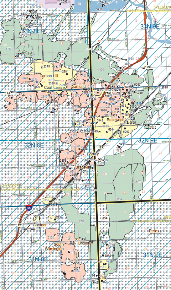 |
| Mine Map via Counties I added this image to Roger's post I have noticed a lot of strip-mining land scars around Braidwood, IL. Evidently, this one mine did most of that mining. Mine index 359 in Will, 675 in Grundy and 834 in Kankakee is most of the green land in this map. Green means abandoned strip mine. William Oldani Dennis DeBruler Woah! Not Land Scars, Tattoos! We’re proud of out Tattoos! Dennis DeBruler William Oldani Now I have to remember to fix my notes from "land scars" to "tattoos." |
The only tipple I could find was in Will County, which I marked with a yellow rectangle.
Roger Kujawa posted six images with the comment: "Wilmington Will County Illinois Coal Mining Postcards."
This is a different exposure of Photo 1 above.
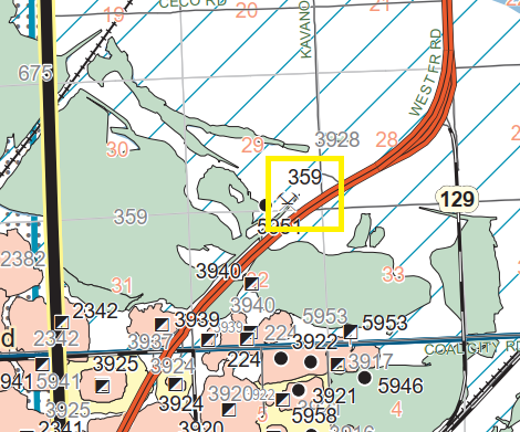 |
| Zoomed in on the above map. |
 |
| Dennis DeBruler commented on Roger's post The tipple was up by the Cinder Ridge Golf Course. In this 1939 aerial, I can see that each leg of the golf course was a railroad yard. SantaFe had a spur from the west and GM&O had a spur from the east. |
 |
| Dennis DeBruler commented on Roger's post |
 |
| Dennis DeBruler commented on Roger's post The now abandoned industrial spurs to the tipple, https://www.google.com/maps/d/viewer... |
Roger Kujawa posted six images with the comment: "Wilmington Will County Illinois Coal Mining Postcards."
 |
| 1 |
 |
| 2 |
 |
| 3 |
 |
| 4 |
 |
| 5 |
 |
| 6 |
This is a different exposure of Photo 1 above.
 |
| Roger Kujawa posted Wilmington Illinois Coal Mining Tipple Real Photo Vintage Postcard AA112106 seen on eBay. |
 |
| Nicholas S Koba Jr. commented on Roger's post here is a photo from farther south down the tracks |
 |
| Roger Kujawa posted [There are lots of interesting comments. Please click the "posted" link.] |
 |
| At image resolution |
Barry Thornberry posted two photos with the comment:
"Flooded Pits of Northern Illinois Coal CorporationMarch 19, 1948 These 2 photos were taken March 19th 1948 , they are from Pit 12 (now the South Wilmington Firemen's Club) The Mazon River ran over it's banks and flooded Pit 12, submerging a Marion 5480 Dragline and a Marion 5480 shove,"Nick Koba Jr. both machines were rebuilt at the new Seminole Mine in 1949 near Lenzburg , Illinois
 |
| 1 |
 |
| 2 |
 |
| Nick Koba Jr. commented on a post This was our largest machine that we had at the mine a Krupp Bucket Wheel Excavator ,it stood 156 feet tall & was 756 feet long. This was the last coal mine in northern , Illinois deep mining end in South Wilmington in 1956. |
 |
| Bill Molony posted This map of Wilmington Township in southwest Will County show a track that connected with the GM&O-ICG southwest of Wilmington and ran west along Strip Mine Road to a connection with the AT&SF, a distance of about five or six miles. I'm trying to determine what purpose this line served, and about when it was removed. Thank you for any information! Frank Smitty Schmidt Wouldn't that have connected GM&O to GM&O? I thought AT&SF had the northern track and GM&O had the southern track between Joliet and Coal City. Josh Biggers Technically yes but I do know the Santa Fe went in there. |
 |
| Josh Biggers commented on Bill's post Dennis DeBruler commented on a post Nick Koba Jr.: Dennis DeBruler the buildings in the center upper end of the photo are still there as the Golf Corse club house it was the mines shop I believe & wash house for the miners to shower & change ther clothes , there also was a spur that ran south of these pits that brought coal from the western Pits & it tie in to the EJ&E rail road just weats of the Coal City Area Club a& southern east side of Goose lake Club. |
 |
| Frank Smitty Schmidt commented on Bill's post Frank Smitty Schmidt I looked at the index composite for the 1939 aerials and can see what appears to be it. Josh Biggers That’s it, they had their own Heisler steam locomotives for working the pits as well. |
Amanda Barker posted four images with the comment: "Shovel in the 1940's I believe at the Peabody Northern Mine."
 |
| 1 |
 |
| 2 |
 |
| 3 |
 |
| 4 |
%20Illinois%20Coal%20Mines,%20Miners%20&%20Railroads%20_%20Shovel%20in%20the%201940's%20I%20believe%20at.png) |
| Comments on Amanda's post |
Abamand Barker posted 11 photos with the comment: "More of the Peabody Northern Mine Dates says June July Aug 1968."
 |
| 1 |
 |
| 2 |
 |
| 3 |
 |
| 4 |
 |
| 5 |
 |
| 6 |
 |
| 7 |
 |
| 8 |
 |
| 9 |
 |
| 10 |
 |
| 11 |
Bonus Flooding
 |
| Phil Elkins posted Dennis DeBruler: Pit #12 of Northern Illinois Coal Corp. had Marion equipment. So I do wonder where this pit was in Illinois. https://towns-and-nature.blogspot.com/2019/06/wilmington-il-northern-illinoispeabody.html |


