Saturday, August 5, 2023

Gillette, WY: 1907 CB&Q Roundhouse and Water Tower

(Satellite, the roundhouse was removed by 1970. There are no obvious remnants.)

Note the water tower on the left. The building with the derrick on top would be the pumphouse. The water supply and bigger roundhouse were built in 1907 by the CB&Q, and the water supply was the lifeblood of the town. [GelletteNewsRecord]
Rick Shilling posted

1971 Gillette West and East Quads @ 24,000

Dennis DeBruler commented on Rick's post
The oldest topo maps I could find where 1971 and this 1970 is the oldest aerial photo I could find. So I don't know where the roundhouse was located.
 https://earthexplorer.usgs.gov/scene/metadata/full/5e83d8e4870f4473/AR1VCNI00010285/
Howard James Holub: I see signs of a location on your photo. Look at the bottom of the left group of homes where you will see a radius close to the road and possible wiskers. Also signs of another small radius which would match up to where a TT would be. An other maker would be at the top over the walkover bridge. Almost looks like a small building was place over the center of where the RH was located.

Richard Shulby commented on Rick's post
GREAT PHOTO! Thanks for posting!. I'm going to suggest a slightly different location for the roundhouse. According to my research and the referenced article the (larger) roundhouse was built in 1906-1907 just after the Burlington & Missouri (CB&Q) built a larger water tank and pumphouse just east of the depot. https://www.gillettenewsrecord.com/.../article_6477c146... . Per the attached 1970 Historic Aerial, I believe the green circled items are the passenger and freight depots, the red circled item with the tall shadow is the water tank you see in the photo, and therefore the blue items would be the turntable and roundhouse. Not definite, but my best guess.


Dwight, IL: Consolidated Grain & Barge (CGB) Grain Elevator

(Satellite)

Some sources specify the town of Gardner instead of Dwight. I do wonder why they didn't build it west of Dwight so that it would be closer to an I-55 exit.

Joseph Tuch Santucci posted
Loading a grain train at an elevator near Dwight, IL in July 2019. The train loads in motion with it moving about one half of one mph.

Dennis DeBruler commented on Joseph's post
Along the former NYC Kankakee Belt. This was still a cornfield in Aug 2010.
Google Earth, Nov 2011

Dennis DeBruler commented on Joseph's post
They added the long building between May 2015 and Apr 2017.
https://www.google.com/maps/@41.0990081,-88.3453593,226m/data=!3m1!1e3?entry=ttu

The elevator did not have a company name label on Google Maps, so I used street view to find a Consolidated Grain & Barge sign. While I was at it, I noticed that there was a train on the loop.
Street View, Dec 2021


Friday, August 4, 2023

Conde, SD: Aban/C&NW/M&StL Depot and Grain Elevators

Depot: (Satellite, it was west of 2nd Street.)
Grain Elevators: (Satellite, steel bins have been added on the north side)


Technically, I should have labeled these notes as "rrOther" because Minneapolis & St. Louis became part of the C&NW after 1928, but the label "rrCaNW" is more informative.

Chicago & North Western Historical Society posted
Here we see a photo of the C&NW depot in Conde, South Dakota. Conde was originally on an M&St.L line. The photo was taken after the depot had been abandoned. Conde is located one station stop north of Doland, SD and midway on a line from Watertown to Aberdeen.
Baron Behning: As I understand it the M&St. L had plans to cross the Missouri River at Akaska but was stopped due to the high cost.

Dennis DeBruler commented on the post
The depot was just west of 2nd Street. And there was a route that went to the West as well as to the Northwest. That route does not appear on a 1958 topo map. The old wooden grain elevators are still standing.
 https://earthexplorer.usgs.gov/scene/metadata/full/5e83d8e4870f4473/ARA001130323963/

Street View, Oct 2008

Michael Behm commented on the post
This is the mstl depot from Nahon SD. They were on the same line. My picture from 6-23-18. Conde looks like it was the same style of depot.
Dennis DeBruler: Where is this building located today?
Scott Leonard: Dennis DeBruler Centennial Village at fairgrounds in Aberdeen: https://www.flickr.com/photos/89330988@N04/8148787721

Dennis DeBruler commented on Scott's comment
Thanks   https://goo.gl/maps/tDJr4gDD3H5GRB6v5

The town of Nahan, SD, is gone.
Satellite


Thursday, August 3, 2023

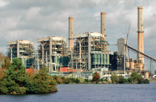
Tatum, TX; 1977 2.4gw Martin Lake Power Plant, Lignite Coal Mine and 5 Marion 8750

Power plant: (Satellite)

The coal mine covered a lot of the land in the area.

"Unit 1: 793.2 MW (1977), Unit 2: 793.2 MW (1978), Unit 3: 793.2 MW (1979)" [gem]

Steve Kole posted
Marion 8750 Dragline (95 CY) at Texas Utilities
Martin-Lake Lignite Mine Along with CAT
D9H Crawler Track Dozer Walking Across a Texas Farm to Market Road near Beckville-Tatum-Henderson, TX--December,1980
This Dragline is the one of five 95-CY Draglines
that were built for Texas Utilities Martin-Lake
Lignite Coal Surface Mine near Beckville-Tatum-Henderson, TX.
To assemble this 95-CY Dragline on site
required a crew of approximately 35-men
working 60-hours per week for a period of
18-months which totals to approximately
165,000-man hours.
The five Draglines were removing enough
overburden soil to allow 40,000-tons per day
of Lignite Coal to be uncovered which was
the amount required to be burned by the
Power Plant each day.
This amount of Lignite is equivalent to a
4-Mile Long Railroad Train each day.
Note the four 3-inch diameter Wire Cable
Drag Ropes for pulling in the bucket.
The Hoist Ropes require the same number
and size.
--Steve Kole Photos-December, 1980
--I have 34-Facebook Albums of Historical Photos
totaling over 1,000 photos.
Majority are in color, many have interesting written descriptions.
To view my 34-FB Albums, follow these 2-Steps.
--MOBILE DEVICES:
Toggle down Facebook Page, select the following:
Step 1.) Photos (Gray oval tab under the word Post)
Step 2.) Photos -----Uploads-----Albums-----Videos
(Select Albums and my 34-FB Albums will appear)
--PC DESKTOP COMPUTERS: Click LINK below:
--FEEL FREE TO DOWNLOAD THE PHOTOS, please acknowledge photos were taken by
either Skeet or Steve Kole as indicated.
--Steve Kole
Email: awssixwheeler@gmail.com
Steve Kole shared

2 of several mining photos added by Steve Kole with the comment:
--Bucyrus-Erie 2570 Dragline (95 CY) at Texas Utilities Martin-Lake Tatum Lignite Surface Mine Along with a CAT D9H Crawler Track Dozer, Two CAT Motor Graders and Two CAT 637D Twin Engine Scrapers-Beckville-Tatum-Henderson, TX--December,1980

This Dragline is the one of five 95-CY Draglines
that were built for Texas Utilities Martin-Lake
Lignite Coal Surface Mine near Beckville-Tatum-Henderson, TX.

To assemble this 95-CY Dragline on site
required a crew of approximately 35-men
working 60-hours per week for a period of
18-months which totals to approximately
165,000-man hours.

The five Draglines were removing enough
overburden soil to allow 40,000-tons per day
of Lignite Coal to be uncovered which was
the amount required to be burned by the
Power Plant each day.

This amount of Lignite is equivalent to a
4-Mile Long Railroad Train each day.

Note the four 3-inch diameter Wire Cable
Drag Ropes for pulling in the bucket.

The Hoist Ropes require the same number
and size.

--Steve Kole Photos-December, 1980

-------------------NOTICE----------------------

--I have 34-Facebook Albums of Historical Photos
totaling over 3,000 photos.

Majority are in color, many have interesting written descriptions.

To view my 34-FB Albums, follow these 2-Steps.

--MOBILE DEVICES:
Toggle down Facebook Page, select the following:

Step 1.) Photos (Gray oval tab under the word Post)

Step 2.) Photos -----Uploads-----Albums-----Videos
(Select Albums and my 34-FB Albums will appear)

--PC DESKTOP COMPUTERS: Click LINK below:
https://www.facebook.com/steve.kole.988/photos_albums

--FEEL FREE TO DOWNLOAD THE PHOTOS, please acknowledge photos were taken by
either Skeet or Steve Kole as indicated.

--Steve Kole
Email: awssixwheeler@gmail.com
Steve Kole shared
Michael Murphy: Getting that bench ready.
William McKinney: I figure these photos are late 70s early to mid 80s good ole days😉
a

b


The open air design of power plants in the south still looks strange to me.
Street View, May 2023

Luminant


Wednesday, August 2, 2023

Harrison C: Short Creek Township, OH: Termel Coal Mine and B-E 1260W

(Satellite, don't know. I could not find anything in a Google search)

Harrison Coal & Reclamation Historical Park posted 17 photos with the comment: "Thanks Bob Burlenski for providing these photos."
Harrison Coal & Reclamation Historical Park shared
Michael Davis: It would eventually become the 1260 for Peabody’s Sinclair Mine In Muhlenberg County, Kentucky
1

2

3

4

5

6

7

8

9

10

11

12

13

14

15

16

17


Tuesday, August 1, 2023

Oakland, NE: Aban/C&NW/CStPM&O Depot & Water Tower, CB&Q and Ag Support

(Satellite, I think today's gas station is on the land of the CStPM&O depot.)

Wandermore's Visit531Nebraska posted
Historic Photos of Nebraska 📸
Oakland, Nebraska — A train departs from the Chicago, St. Paul, Minneapolis & Omaha Railroad depot, which was responsible for bringing many of the early inhabitants and industries to what would eventually become “the Swedish Capital of Nebraska.” The railroad opted to name their depot and the townsite “Oakland” in honor of early settler John Oak.
-
I will sometimes share old follower-submitted postcards and photos of Nebraska! I would encourage those who used to live in Oakland and the surrounding area to comment any memories, history, or anecdotes that they may have about the photo or town. 😄📸
-
Want to read up on state history and enjoy tens of thousands of photos of Nebraska’s towns taken in the 2020s? Consider checking out my Nebraska history book/travel guide! It’s jam-packed with restaurant recommendations, fun facts about the state, access to tons of photos through a unique QR code system, and a LOT more! (Please note that the book does not contain historic photos such as the one shown in this post!) WandermorePublishing.com/shop
Mike Bartels shared

The C&NW used to be west of the CB&Q when it went through town. They crossed each other at 
Fulton Street. Today, only the CB&Q route remains.
1966 Oakland Quad @ 24,000

EarthExplorer: Jul 23, 1953 @ 66,500; ARA001280020386

I put "Ag Support" in the title instead of the usual "Grain Elevators" because in this town putting seed and chemicals on the fields is a bigger business that taking crops off of the fields.
Seeds and Chemicals

In addition to various chemicals used to fertilize crops, I've noticed from watching farming videos that modern agriculture has become very dependent on "cides" (fungicides, herbicides and insecticides).

Some of the C&NW RoW is now occupied by grain elevators. The long building near Fulton Street is slanted because it was parallel to the C&NW as it curved to cross the CB&Q. You can see that building next to the tracks in the above topo map.
Satellite


Sioux City, IA: C&NW/CStPM&O Roundhouse and Cargill Soybean Plant

C&NW Roundhouse: (Satellite, you can still see the round foundation of the east wall.)
IC Roundhouse: (Satellite, it is completely removed)
Cargill: (Satellite)


The C&NW presence in this city was primarily this north/south route. In fact, the C&NW route to the east had been abandoned by 1955.

Chicago & North Western Historical Society posted
It is said that this photo shows the "Omaha" road's Sioux City roundhouse. It certainly must have been a very busy place. The date of the taking of the picture is on the reverse of the photo. It says "1905".
Mike Bartels: The April 6, 1959, Sioux City Journal said toppling of the 178-foot stack at the roundhouse on April 5th shook houses as far as six blocks away, prompting many calls to fire and police switchboards about whether there had been an earthquake or explosion. The article said the roundhouse and other buildings were being torn down.
Raymond Storey shared

Tom Edwards commented on the above post
As I studied this area a bit more, I'm thinking that the roundhouse in the original post is not the one that I found on the Sanborn insurance map. I think that this roundhouse must be even newer than the "New Roundhouse" shown on the 1902 map.
I copied and pasted three pieces of the 1902 Sanborn maps onto this Google Satellite view and then I marked the location of the most recent roundhouse with a a yellow circle. Zoom in on Google Maps at that location and the eastern foundation of the roundhouse in the original photo can be seen.
I'm basing this on the street names and the fact that the tracks curve to the northeast right past the roundhouse.

Richard Shulby commented on the above post
This is another clue. A piece of 1959 C&NW track chart showing the roundhouse that matches the original photo located north of 13th Street. The 1902 roundhouses were both south of 12th Street.
So, this adds up to three roundhouses for the Omaha in Sioux City. Thoughts anyone?
Richard Shulby commented on Raymond's share
If you click on the photo you can see the original post and all the comments, including mine. This was the 3rd CStPM&O roundhouse in Sioux City, located at 42°30'23.71"N 96°23'35.06"W and shown on the attached 1917 map. It was demolished in spring of 1959.

Dennis DeBruler commented on Raymond's share
1953 aerial. Note the small roundhouse north of today's Cargill property. I presume that was an IC roundhouse.
 https://earthexplorer.usgs.gov/scene/metadata/full/5e83d8e4870f4473/ARA001320162492/

The foundation remnant of the C&NW roundhouse:
Satellite

The southern part is labelled soybean plant. I wonder if the northern part is ethanol.
Satellite

Street View, Aug 2022

Street View, Aug 2022

During the harvest season, the lineup of 18-wheelers is even longer. this explains why I could not find any railroad hopper unloading facilities at this plant. They do load tankers and hoppers.
Street View, Oct 2021