Wednesday, March 4, 2015

Rose Hill, IL

Like Hidalgo, IL, I found Rose Hill when I noticed a commercial grain elevator that initially looked like it was in the middle of corn fields as I was driving north on IL-130. So I turned west when I got to IL-6. As I approached the town, you could clearly see a hill in the road where it went up to meet the grade of the former IC/PD&E. Below are views looking North and South, respectively.

20140128-0202 0002


At first, I assumed this was a local grain elevator since it has not had railroad service for a few decades. But it is rather large for a local elevator, and I could not find a building in which it would have the grinders and mixers needed to prepare livestock feeds. And then I noticed that it has a loading bin over the old right-of-way. And another loading bin with the second complex to the west. These loading bins would allow them to quickly fill a grain truck. But the grain elevator to the north in Greenup doesn't have a connection to the CSX/Penn railroad past that town. However, there are a couple of rail-served (CN/IC/Indianapolis Southern) elevators south near Newton.


Satellite
Because this line has been abandoned for a while, it demonstrates that if a farmer does not claim the right-of-way, it becomes full of trees. What I find interesting is that some farmers do claim the right-of-way and make it part of their fields whereas others didn't bother. The satellite image is on the north side of town. The following is a picture of the north side of town. Then I zoom into the trees that are on the right-of-way.


Since this blog is Nature as well as Towns, I include a sunset we caught a little later during this trip. The digital camera with the default settings did a good job of catching the colors that caught our eye.


Wednesday, February 11, 2015

Perrysburg, OH: Fort Meigs and Low River Level

From the parking lot, you can catch the west side of Fort Meigs and a tall white monument in the middle behind a tree.


20150210 0006c
It was built in 1813 at the Maumee River rapids to support the War of 1812. It is one of the largest log forts in America.The 10-acre log enclosure has 7 blockhouses and 5 emplacements. (FortTours) The logs are 15 feet high and earth embankments are used to protect them from bombardment.

The British and indians did lay siege against the fort two times, but both attempts failed. The fort was dismantled after the war, but the land owner, Timothy Hayes, preserved the land in memory of the men who fought the battles. In the late 1960s, the Ohio Historical Society reconstructed the fort. (Wikipedia) The fort's web site indicates the reconstruction was done in the 1970s.

 I visited on a day when the visitors center was closed. Below is a picture that ties together the visitor center and the west side of the fort. It also has a clearer shot of the white monument in the fort.


I present the historical markers in the order in which I encountered them from the parking lot. The fort was built to help mount the War of 1812.

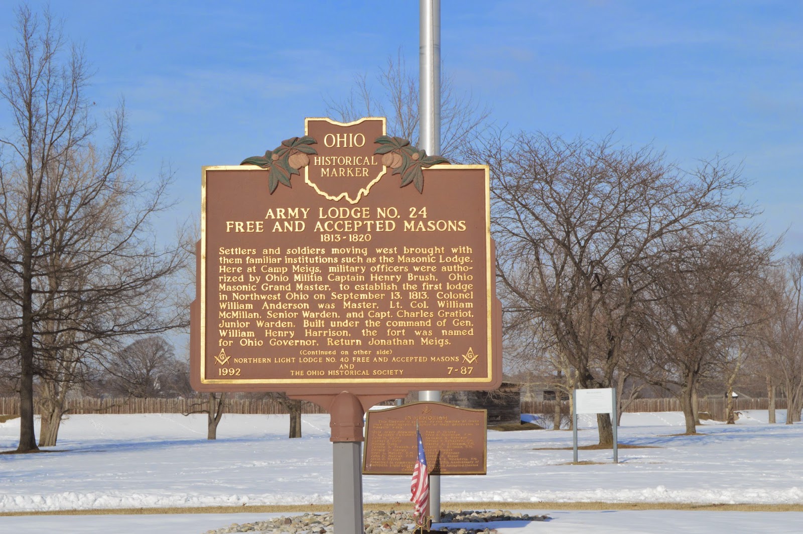
"ARMY LODGE NO. 24 FREE AND ACCEPTED MASONS 1813-1820

Settlers and soldiers moving west brought with them familiar institutions such as the Masonic Lodge. Here at Camp Meigs, military officers were authorized by Ohio Militia Captain Henry Brush, Ohio Masonic Grand Master, to establish the first lodge in Northwest Ohio on Spetember 3, 1813. Colonel William Anderson was Master. Lt. Col. William McMillan, Senior Warden, and Capt. Charles Graflot, Junior Warden. Built under the command of Gen. William Henry Harrison, the fort was named for Ohio Governor, Return Jonathan Meigs." (I did not tromp through the show to get a picture of the other side.)

"AMOS SPAFFORD

In 1810, some of the first American settlers in this area were Major Amos Spafford (1753-1818), his wife Olive (1756-1823), and their children Samuel, Aurora, Chloe (Mrs. Almon Gibbs), and Anna (Mrs. Richard Craw). In 1796, Spafford, a native of Connecticut, was a surveyor for the Connecticut Land Company He drew the first map detailing the layout of Cleveland and named the city. He left that area in 1810 following his appointment as custom's collector and postmaster for the new port at the foot of the Maumee River rapids called Port Miami of Lake Erie. Major Spafford was granted a 160 acre land patent on the River Tracts No. 64 and No. 65 in Waynesfield township, signed by President James Monroe and was able to purchase it following the 1817 Treaty of the Repids that extinguished Native American claim to the land. Two years later, sixty-seven families lived in the area, but most fled at the outbreak of the war of 1812."

 "17TH INFANTRY REGIMENT

The 17th Infantry, created by Congress in 1812 and formed with personnel from western states, was the only Regular Army regiment in General James Winchester's column of the Army of the Northwest's compaign to regain Detroit. During the war of 1812, the 17th fought at Frenchtown, Fort Meigs, Fort Stephenson, and Thames River. In 1815, the 17th was consolidated with the 5th, 19th, and 28th Infantry to form the 3rd Infantry. In May 1861, the 17th Infantry was again organized as a Regular Army regiment and has since served continuously with distinction.
The regiment served in Ohio at Columbus Barracks from `1894 until 1899, where, after the Spanish-American War, the American Veterans of Foreign Service, Philippine Insurrection, Mexican Border Campaign, World War II, Korean War, Vietnam War, and expeditions in Panama (1889-1990). The regiment was decorated with the Presidential Unit Citation for the Leyte Operation, The Philippine Presidential Unit Citation, and four Republic of Korea Presidential Unit Citations. Seventeen members of the 17th infantry have been awarded the Medal of Honor."

Low River


Meteorologist Chris Vickers posted
That’s the BOTTOM of the Maumee river in Perrysburg as water have been drained from western Lake Erie due to high winds. This displacement of water back and forth is commonly known as a seiche where the winds drive the water level fluctuations back and forth, similar to water sloshing around in a bathtub.
[Perrysburg is about 10 miles from Lake Erie. I'm surprised the river drains this far upstream.]

A more normal river level. This view is looking downstream from Maumee Riverside Park.
20150410 0168

Gary Thompson commented on Chris' post
Bay shore fishing access behind the refinery..

David McCulloch commented on Chris' post
Sterling State Park, Monroe MI. Gained about 200 ft of shore line because of the strong winds.

Charles Gast Jr commented on Chris' post
Clemon's marina just dredged a channel this summer.

Dustin Butler commented on Chris' post
This is the end of the peninsula in point place giant sandbar.

Tuesday, January 27, 2015

Hidalgo, IL


I've learned that small commercial grain elevators are an indicator of abandoned railroads. And I knew that the abandoned Peoria, Decatur and Evansville Railway was near parts of IL-130. So when I saw an old grain elevator, I turned west on IL-13 and found the town of Hidalgo, IL. The above image is from the side of their Post Office.

The image to the right is looking southish along the abandoned right-of-way.
Looking north and including the grain elevator.

When I first studied a satellite image, I was confused because there were more circles in the image than there were bins in the picture. Then I realized that the southern five circles are just foundations, not bins.
Moving a little to the east to capture the vacant land that is now next to the right-of-way. I have discovered that the PD&E is well documented and it provides a detailed list of the railroad facilities that would have occupied this land. The town was reached by the railroad in 1877 and the railroad laid out the town the following year. The track was closed Aug. 1, 1982, and removed later that year.


ILHAP
Before I found the www.thepde.info list of RR facilities, I found a 1938 aerial photo. It surmise that the black rectangle at the intersection of the railroad and the state highway is the depot.

Studying the grain elevator once again demonstrates how today's satellite images from space have better resolution than aerial photos in the late 1930s. In this case, I think the black circles are the abandoned bin foundations. Where these poured during the roaring 1920s and then abandoned because of the depression; or were they poured closer to 1938, but construction was aborted because of the war?

Satellite
The shadows in a Bing map clearly shows which circles are bins/silos and which are just foundations.

Because of the rather decrypt shape of the elevator (below) and because the capacity is not much bigger than many farmers currently have, I'm going to assume that it has been abandoned.

Frankfort, IN: NS/NKP Coal Tower, Roundhouse and Railyard

Coaling Tower: (Satellite)
Roundhouse: (Satellite)
Railyard: (Satellite)

(Update: my uncle sent me some more pictures of the roundhouse.)

One of 22 images posted by Ben Funderburg
Some shots of the former Nickel Plate Roundhouse in Frankfort, Indiana. Built in 1924 and last used by Norfolk Southern in 1996. Preservation efforts were still planned as of 10 years ago but clearly haven’t come to fruition. I reached out to several different historical societies and preservation groups and no one was able to give me any information on that front.
The last few pictures are from the adjacent depot, which from poking around inside seems to have last been used by Norfolk Southern around 2005-2006. Sadly, just days after my visit the depot fell victim to arson and is now mostly collapsed.
Bob Sannino what a shame they cant find a way to re-purpose theses old buildings.
Ben Funderburg Bob Sannino I read that a $49,500 grant was issued in 2009 towards the preservation of the complex but I have no idea what became of that money.


20140829-30 0001
I was heading East on Indiana State Road 28 approaching Frankfort when I saw a coaling tower to the North. Coaling towers are a "must stop industrial history structure" short of being on an Interstate. In this case I was doing just 35 mph and it was easy to find the access road. Unfortunately, I soon encountered a Norfolk Southern No Trespassing sign. But there was a parking lot next door, so I stopped and put on the telephoto lens.
Raymond Breyer posted
We all know what Frankfort's coal tower looks like today, but here's the original plant from 1915.

Jason Leverton posted
An old call box and coal tower on the former Nickel Plate at Frankfort, IN.
Larry Layden: In the 70's and 80 ' s the call boxes were still being used in the CB&Q freight and passenger yard at Lincoln, Nebraska. Before we had radios the only way switch men and train men could contact the interlocking operator was to find a call box. There were around a dozen wired into Carling Tower, where I worked. Every phone had a crank used to ring the operator. When a bell rang in the tower it could be one of 20 phones. 12 callboxes, 4 dispatchers, 3 yardmaster and one PBX line. I had a row of 20 Jacks on my desk and I would work down the line, plugging each jack into my headset and answering "carling" until someone responded. Of course no one rang just once, they would ring 3 or 4 times, thinking I needed to be woken up. [This comment is why I saved this photo.]
Tom Nebelsick: Larry Layden I’m glad that was all gone by the time I got to work there. Wish I knew a way to get a tour of the “new” Carling Tower......
Larry Layden: Tom Nebelsick Not much to see. The front row has the departure yardmaster and the hump yardmaster The second row has three computer stations. The one on the easside was vacent, Carling was in the middle and a carmen was on the west side of the row. Carling had four large computer screens with keyboards all over. In the middle of the desk was one of the keyboards, another one was on rollers underneath the desk. They have probably managed to add three or four more screens by now stacked two deep. It was a bit ch of a job. The back row had a roundhouse foreman to the west, Trainmaster right behind Carling opr, desk to the east was vacent. Every so often they would pile more work on us. We had to issue track permits and block out tracks for the roundhouse and carmen.

Below is a view of the buildings to the west of the access road. I didn't know it at the time, but the brick building behind the trees on the right is part of a roundhouse.

There was a thick tree line along the south boundary of the property. But those buildings looked old enough to be from the steam era so I walked along the boundary hoping for a break in the tree line. And I found one.
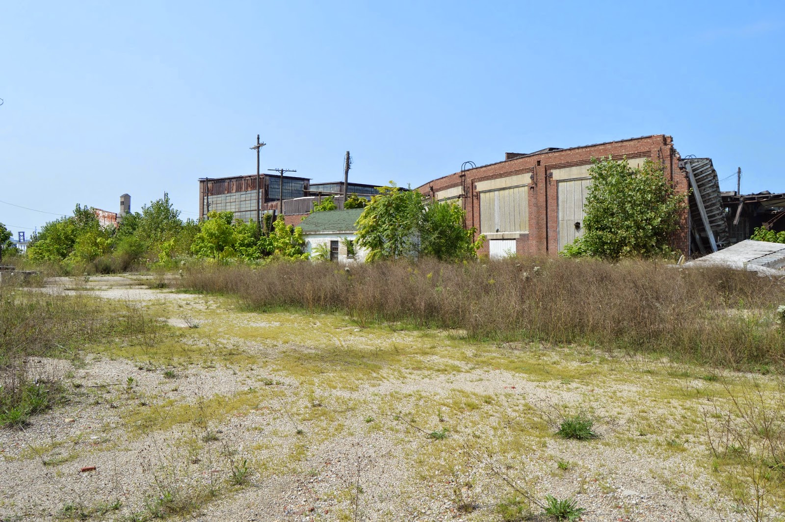
The following 4 pictures are a series starting from looking West to looking East. The first view is of some of the buildings seen in the above picture. The remaining pictures pan across the backside of the roundhouse. Note the collapsed section. They are right, you would not want to walk around in those ruins.


Since I had seen no activity anywhere the entire time I had been there, I walked a few steps onto their property and took shots towards the West and the East. Note that in the western (left) view, you can see the top of the coaling tower near the left side of the picture.


On the way back to the car, I took a view that caught the buildings on the right and the coaling tower on the left to provide some context for  the buildings and yard.
Later, I studied some satellite images to see what was left of the turntable and to determine if the other side of the roundhouse is visible from public land. It does not appear to be visible. But the satellite photo does show that the turntable still exists. But all of the track is torn up because scrap steel has value. And over a third of the stalls have been torn down. It appears that more of the roundhouse has collapsed since the satellite photo was taken.

Satellite
Update:
Mike Finney posted
Frankfort Yard from the air looking east.
Frank Williams: Easy to see it is a well maintained NS yard - for now.

An updated satellite image shows that not only has more of the roof fallen in, but trees are starting to grow inside the building!
2019 Satellite

Keith David posted
The above views are from the south. Doug got a view from the north side.
Photo by Douglas Weitzman, used with permission
Sept. 2015 Photo by Douglas Weitzman, used with permission
A popular view.
Mark Hurlbutt posted (source)
Frankfort Roundhouse INDCameron Balaban Is this a current picture or one from your collection from years back?
Mark Hurlbutt 3 years ago.
Christopher Clutter Pigeons, got to love them! Thanks for sharing the history!
Michael Maitland What a place this must have been. NKP terminal as well as 2 PRR lines and the Monon, all in one condensed area.
[It is interesting that the metal has yet to be stripped. Scrap value doesn't cover the labor?]

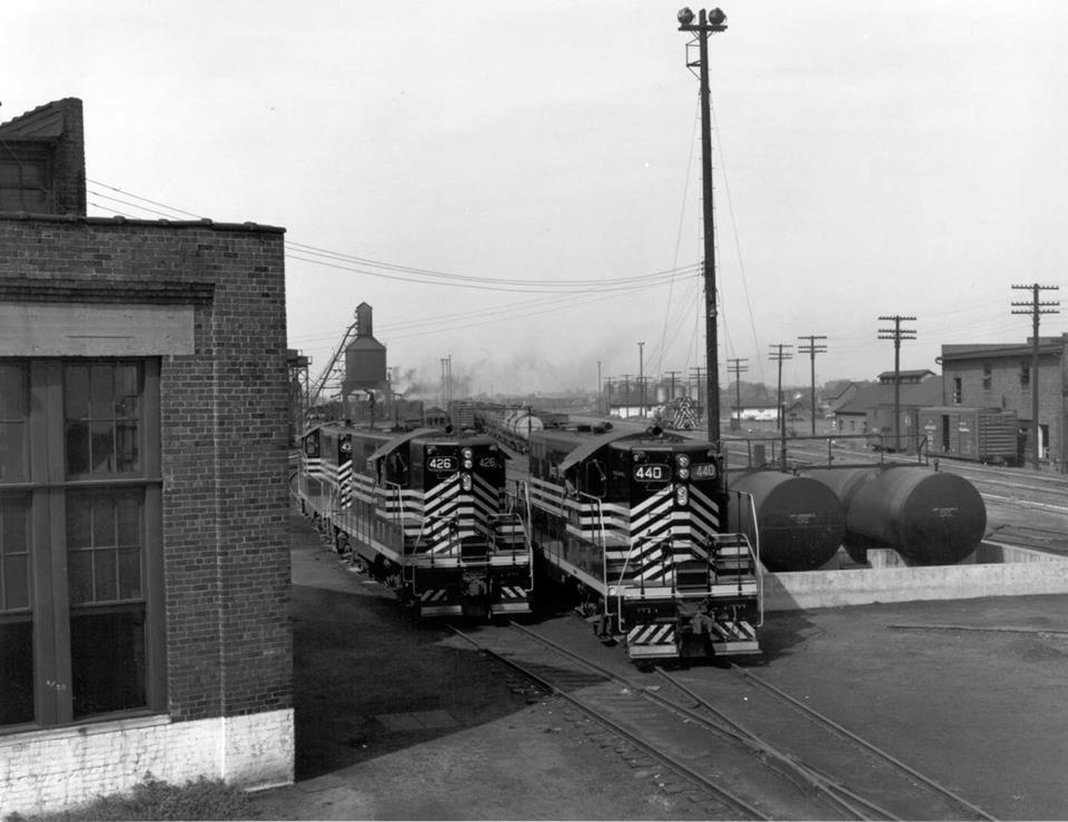
Back when it was being used. Note the standpipe for filling the tenders.
The Nickel Plate Road Historical & Technical Society, Inc. posted
NKPHTS member Bill Fisher thinks he may have taken this photo at Frankfort, IN. ”I didn’t record any train info,” Bill says, “I was more interested in absorbing the beautiful sights and sounds and aromas.” We’re glad he did.
Tony Koester Collection
https://www.nkphts.org/
Tim Shanahan shared
Dennis DeBruler commented on Tim's share
It is nice to see what it looked like when it had all of its metal parts. The standpipe is long gone. I read that they plant to tear it down so that they can expand the yard.
https://www.google.com/maps/@40.2820609,-86.5250924,119m/data=!3m1!1e3

A different view because it requires being on railroad property.
Brian Knight posted
Unusual lighting with a storm approaching...Frankfort Indiana 1997

(Facebooked without a link 20150926)

Screenshot from a 1953 video
It looks so different.
Would they have built a new coal tower near the end of steam?
Mike Finney posted
Mike's comment:
Frankfort, In. My Dad took all the photos I post including these. These are my favorites that he took by the coal dock. He was actually taking the photo to get the new diesels. Lucky for us the 720 just happened to be there as well. He wanted the photo to be called the coming of the new and the going of the old, as the 452 looks to be coming, and 720 going away in the photo.
Taken around 1955.

Mike Finney posted
Postprocessed by Tony Koester
Blake Daulton posted
The Nickel Plate roundhouse and shops in Frankfort, Indiana back in her glorious times.
Jacob Hortenstine posted
Frankfort Indiana coal dock {Jay Williams photo}
Screenshot from a 1953 video, did they use to have two coaling towers in Frankfort?

Frank Olive posted
Toledo St. Louis & Western 0-6-0 #5
Frankfort, In
Left to right: Tom Allen, Pearl Skiver, Earl Dearth, C. Druckemiller, Frank Mynes, Fred Lorman.
Photo originally uploaded by Steven Grigg 
Shelby Burkhardt posted 11 photos with the comment: Took a ride over to Frankfort IN an took some photos of the old Nickel Plate roundhouse, turntable, and coaling tower. What’s left of it that is.""

1

2

3

4

5

6

7

8

9

10

11


The Frankfort pictures posted by Rails Around Indiana with the comment: "A few black & white prints purchased from photo dealer & friend Jay Williams a few years back depict the NKP at Frankfort and Indianapolis. Photographer and exact dates unknown."
1

2

Locomotive Jordan posted four photos with the comment: "Going back to around the middle 1990's, we see NS using this track mobile at their Frankfort, IN. roundhouse. Back then they had their own car shop in the old Nickel Plate Road roundhouse.— in Frankfort, IN."
1, cropped

2, cropped

3

4

Tim Shanahan shared
[The "now" (bottom photo) was 2011.]

The roundhouse is on the left.
Brian Knight posted
NS Frankfort yard early 1990...Ektachrome slide on a drab day I thought would look better in B&W
 
Jason Leverton posted
The old Nickel Plate coaling tower at Frankfort, IN.
[The comments include a couple more angles of the tower.]
Tim Shanahan shared

Oren B Helbok posted two photos with the comment:
Frankfort, Indiana
The "then" photo appeared on Classic Trains's site at some indeterminate time in the past; the view looks west in the Nickel Plate's former Clover Leaf (Lake Erie & Western) yard, probably in the 1940s.
The "now" photo dates from the 8th of September, 2019; the coal dock stood over the photographer's left shoulder when he made the earlier photo.

1

2


The trees are winning. Accessed Apr 2024.
Satellite


July 2026:
Clinton County Daily News posted seven photos with the comment: "Roundhouse Demolition Begins, Turntable and Machine Shop to Remain.  Learn More:  https://clintoncountydailynews.com/roundhouse-demolition.../"
Matt Lucas shared
1

2

3

4

5

6

7