 |
| John Smith posted
blue is Santa Fe
Pink is Chicago & Alton
Orange is Elgin Joliet &Eastern
Green is Chicago Rock Island
Purple Is New York Central
Dark Orange is Chicago, Milwaukee, St. Paul and Pacific
|
Thursday, October 26, 2017
Joliet, IL: John Smith's Map
This was the layout of the railroads before they were elevated. Each railroad had their own depot back then.

Tesch, MI: Junciton Tower: C&NW vs. C&NW vs. SOO(WC)
(Satellite)
Google Maps can't find Tesch, but Bing could. Knowing where the town is, I found the junction on Google Maps, which has labeled the trails that are on four out of the seven spokes from this junction.
Google Maps can't find Tesch, but Bing could. Knowing where the town is, I found the junction on Google Maps, which has labeled the trails that are on four out of the seven spokes from this junction.
 |
| Chicago & North Western Historical Society posted The photographer, Ed Selinsky, is looking at the "Armstrong" tower located at Tesch, Michigan in May 1971. Who would like to fill us all in on just where Tesch is and where all those tracks are going? What a posting that would have been! Leland Frossard Tesch is on M 69 west about 2 mi up from the us 2 &41 intersection the track to the left past the tower is the soo line going to Gladstone mi. the center is th c&nw ore drag to the docks in Escanaba Mi. the track to the right is the c&nw felch line that connected the c&nw main line in narenta and went through Schaffer ,Perronville,Foster City. I grew up in Tesch our house was about 30 feet from the ore drag and less then couple hundred yards from the tower. Greg Bunce posted Tesch Tower in Michigan's Upper Peninsula looking east.. The track running from the lower right to the left is the Soo Line's line from Minneapolis to Sault Ste. Marie, Michigan. The track running from the top to the bottom is the Chicago and North Western's Ore Line from Iron Mountain to Escanaba. The track across the photo is the C&NW's Felch Branch which ran from Felch to Naranta on the C&NW's main line from Green Bay to Escanaba. All of it is gone. Paul Ernest: With permission from the author, this is a recollection from Robert Grindrod: I Remember this place. The Felch branch was a complete mistake. CNWW built the branch in the 1880s because they thought there was an ore body in Felch. There wasn't.....but the branch lasted into the 1950s carrying some occasional loads of pulpwood. The CNW Ore Line ran from Antoine Yard in Iron Mountain through the woods to Escanaba. The yards that supported the old pocket type ore docks in Escanaba were built along this line, so the ore came into town this way. In practice CNW ONLY ran eastbound loaded ore trains over this route. Empties returned via a different line that ran Escanaba - Powers - Norway to Iron Mountain, so you could say the two lines were run as double track. Diesel power and a gradual reduction in ore movements eliminated the need for the second line. About two miles of new track was built in Escanaba in the early 1960s to connect the two lines there, which allowed the Ore Line to be abandoned about 1963. After that, ore moved via Powers to Escanaba from the from the Iron Mountain area. The last line was the SOO....the old main line from Minneapolis to Sault St. Marie via Ladysmith. Soo had changed from an east - west railroad to a north - south one in terms of traffic. This line remained, but with little traffic. Under Wisconsin Central in the 1990s there was a movement of gold and copper ore from a brand new open pit mine near Ladysmith to points in Canada via Sault St. Marie. This lasted about 4-5 years until all the ore had been removed. Then about 1994 iron ore started moving between mines on the DMIR north of Duluth south to Ladysmith, then east over this line, "north" to Gladstone and Sault St. Marie for Algoma Steel of Canada. The sawtooth profile of this line, light rail and the elderly DMIR ore jennies themselves made moving these trains difficult.....and resulted in an early use of distributed power to keep the trains in one piece and on the rails. To say that Tesch was remote is an understatement. I think CNW had to maintain about 10 miles of pole lines just to get electricity and telegraph to this tower. |
 |
| Phil Martin commented on Greg's post Original model board from Tesch. Heard rumors of it surviving in a hoarder's estate in Esky. 2 hours of digging through the house and there it was under a table. Hidden away for years. |
 |
| Mike Delaney commented on Greg's post |
 |
| Mike Delaney commented on Greg's post 1921 |
 |
| Satellite |
I marked the two C&NW routes in yellow and orange. The blue line is the SOO route. The red circle indicates which "quadrant" (hextant?) the tower was in. Judging from the Felch Grade Trail, C&NW abandoned the orange route to the west because it was redundant with its mainline to the west that went through Narenta. And it abandoned the short yellow route to the south because they wanted to keep the ore drags off the mainline.
 |
| Satellite plus Paint |
 |
| Posting plus Pant |
 |
| Mike Erick Son commented on the posting Here's another shot of the same switch house. |
According to the 2005 SPV Map, there was a mine spur that left the branch east of Felch, MI. I found the tree lines of the spur's connection. I followed the land scars of the spur to here. I assume the "lakes" and rows were part of an iron ore mine.
 |
| Michael R Valentine commented on Greg's post Wow what a cool place! |
 |
| Michael R Valentine commented on Greg's post |
Tuesday, October 24, 2017
Fairmont City, IL: Bunge-SCF Marine Transloading Grain Elevator
(Satellite: City, Facility)
I included the city limits satellite image because it struck me how most of the town is away from the river, but there is a sliver of land that connects it to a small stretch of riverfront property. This Bunge-SCF Grain facility is the only business along Fairmont City's riverfront.
I recognize Bunge as the company that owns some of Central Soya's former soybean processing plants. I know of Bunge facilities in Decatur, IN, Indianapolis, IN, and Cario, IL.
I've noticed that modern facilities that load barges don't have near the storage capacity as traditional port elevators that load ships. That is because they concentrate on going directly from the truck or train to a barge. And since there are no locks on the Mississippi downstream from here, they can export grain using very large tows (e.g. 48 barges). (Tows on the Upper Mississippi and the Ohio River max out at 15 barges.) Large tows make US grain competitive with Brazilian grain.
Dennis DeBruler It is interesting that Bunge gives trucking costs instead of rail costs from Iowa. I assume they truck Iowa grain to St. Louis instead of Dubuque, or other Iowa towns on the Mississippi, because only 15-barge tows can be used on the Upper Mississippi because of the locks. Because there are no locks downstream of Fairmont City, large tows like 48-barges can be used, and they are not delayed by locking procedures.
I included the city limits satellite image because it struck me how most of the town is away from the river, but there is a sliver of land that connects it to a small stretch of riverfront property. This Bunge-SCF Grain facility is the only business along Fairmont City's riverfront.
I recognize Bunge as the company that owns some of Central Soya's former soybean processing plants. I know of Bunge facilities in Decatur, IN, Indianapolis, IN, and Cario, IL.
I've noticed that modern facilities that load barges don't have near the storage capacity as traditional port elevators that load ships. That is because they concentrate on going directly from the truck or train to a barge. And since there are no locks on the Mississippi downstream from here, they can export grain using very large tows (e.g. 48 barges). (Tows on the Upper Mississippi and the Ohio River max out at 15 barges.) Large tows make US grain competitive with Brazilian grain.
The cost to move one ton of grain from Iowa to China figures in $8.38 for trucking, $25.51 on barges and $27.77 on shipping, and then comparing those costs for a ton from Brazil to China, Bunge pegs Brazils’ trucking expense at $76.94 and shipping at $20. Between the truck, barge and shipping costs, the U.S. cost is $61.66 per ton as opposed to $96.94 by Brazil. [agrinews]Luckas Irons posted the arginews link.
Dennis DeBruler It is interesting that Bunge gives trucking costs instead of rail costs from Iowa. I assume they truck Iowa grain to St. Louis instead of Dubuque, or other Iowa towns on the Mississippi, because only 15-barge tows can be used on the Upper Mississippi because of the locks. Because there are no locks downstream of Fairmont City, large tows like 48-barges can be used, and they are not delayed by locking procedures.
 |
| BUNGE-SCF Grain |
 |
| Bunge-SCF Grain |
 |
| Bunge-SCF Grain |
Indianapolis, IN: Monon Roundhouse
(Satellite)
The NKP (L&EW) roundhouse was east of the tracks.
Raymond Storey posted two photos with the comment: "The Monon Indianapolis."
The NKP (L&EW) roundhouse was east of the tracks.
Raymond Storey posted two photos with the comment: "The Monon Indianapolis."
 |
| 1 |
 |
| 2 |
 |
| Ryan Kruse posted
Here's a link to Indianapolis's historic aerial photo archive. Goes back to 1937. I was amazed at how many yards with roundhouses were around. This if fun to see what was and what's now. Does your city have a map like this?
in the photo below. The Monon Yard is on the left and the Nickle Plate on the right.
|
Ponemah, IL: Abandoned Pipeline Pumping Station
(Satellite)
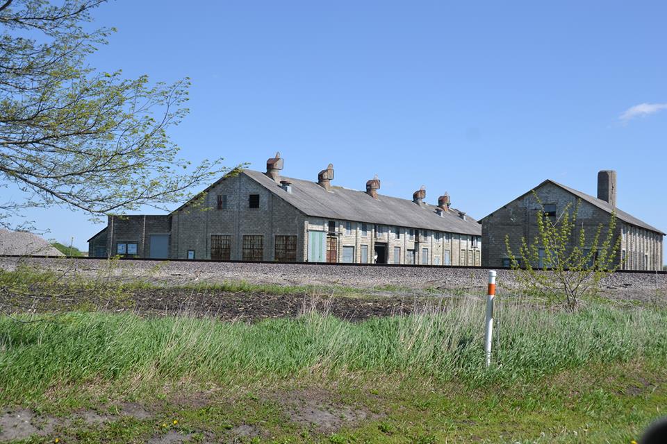
The title is ambiguous about this being a steam or gas/distillate powered pumping station because John lists it as a steam oil pipeline pumping station but it looks like a gas/distillate pumping station. Note the orange-stripe-on-white pole. This right of way is not only used for tacks and oil pipelines, it is used for fiber optic cables.
The title is ambiguous about this being a steam or gas/distillate powered pumping station because John lists it as a steam oil pipeline pumping station but it looks like a gas/distillate pumping station. Note the orange-stripe-on-white pole. This right of way is not only used for tacks and oil pipelines, it is used for fiber optic cables.
 |
| John Carson commented on Roger's posting Ponemah |
 |
| Street View |
Dahinda, IL: Abandoned Pipeline Steam Pumping Station
Pump: (Satellite)
The "Pumping Station Road" made it easy to find these pipeline pumping station buildings.
The oil storage tanks caught my eye so it was easy to include the pumping station with the depot.
The "Pumping Station Road" made it easy to find these pipeline pumping station buildings.
Depot: (Satellite)
I included the land that held the two oil storage tanks.
 |
| Satellite |
Trent Briggs posted two photos with the comment:
Dahinda, IllinoisOriginal and second depots. ATSF
.jpg) |
| 1 |
.jpg) |
| 2 |
The oil storage tanks caught my eye so it was easy to include the pumping station with the depot.
 |
| 1940 Aerial Photo from ILHAP |
Marceline, MO: Santa Fe Depot and Coaling Tower(s?)
Depot: (Satellite) It now is the Walt Disney Hometown Museum
Coaling Towers: (Satellite) |
| Marty Bernard posted AT&SF Depot, Marceline, MO in August 1983 Roger Puta photo Trenton Dominy: This depot is now the Walt Disney hometown museum to bad they couldn’t combine that with an active train station. |
 |
| photo, Oct 2020 |
While looking for oil pipeline pumping stations, I noticed an elevated round silo in the middle of a vacant part of the BNSF/Santa Fe Yard. I wondered if that was a coaling tower. Then I saw the elevated rectangular building to its northeast that is definitely a coaling tower. The town is about half-way between Fort Madison and Kansas City, so it was probably a division point. Evidently the need to add coal to the many trains that the Santa Fe ran between Los Angeles and Kansas City to Chicago became so large that they built the round one to supplement the number of tracks served by the rectangular one. Note that the coal unloading sheds shared the same coal service track.
 |
| Street View |
I think the guy driving the Google Street View car was a railfan. He went down about every side street to get close to the BNSF yard.
Update:
 |
| Street View |
 |
| Street View |
 |
| Street View |
 |
| Andrew Simpson commented on a post Marceline, Mo still has one. It is the boyhood home of Walt Disney and Main Street was the inspiration for Disney Main Street. Built in 1902. |
 |
| Dale Hearn posted Westbound Santa Fe 5852, an SD45-2, a 9500 series SF30C and a GP30, throttle up as they come around the curve and pass the old steam engine service facility on the west side of Marceline, MO. Aug. 10, 1991. Dale Hearn photo. Ryan Dorrell Now the coal facilities are just a big fancy MOW garage. Ryan Dorrell I’m originally from there. My Dad was a conductor there from 70’s to 90’s until they closed the depot and he got moved to Ft Madison. I’m back there several times a year. The depot is now the Walt Disney Hometown Museumand two years ago also became home to an SD40 #5008 Friends of the ATSF 1708 which has received lots of cosmetic restoration and looks great. |
 |
| Ryan Dorrell commented on Dale' post, cropped |
 |
| Ryan Dorrell commented on Dale' post, cropped |
 |
| Ryan Dorrell commented on Dale' post, cropped |
 |
| StormySky Rail Productions posted Coaling tower at Marceline, MO in 2018. This has since been torn down. |
Subscribe to:
Posts (Atom)