Monday, July 27, 2020

Ashtabula, OH: Pennsy roundhouse still stands

(Satellite)

Josh Guerney posted two photos with the comment: "The abandoned PRR Ashtabula roundhouse."
Dennis DeBruler I didn't even know PRR had a branch up to Ashtabula. I see Conrail was the one that abandoned the branch. https://www.google.com/.../@41.8743858,-80.../data=!3m1!1e3

[I'm sorry that the links in the above text are garbage. Google is threatening us with a new version of blog authoring software that is far worse than the existing version. One of the joys of the new version, which they are still claiming is an improvement, is that, when you copy text onto a clipboard, it replaces the link in every URL with garbage. I reported this corruption of user data weeks ago. In fact, more than once. But, like all other feedback, it seems to have gone into a bit bucket. I now try to go back to the old version before I copy text, but I forgot in this instance.]

1

2

Street View
Bob Mcgilvray Jr. posted three photos with the comment: "Ashtabula, Ohio - Pennsylvania Railroad roundhouse - January 2020 - 41.874380, -80.798523"
[These notes seem to be jinxed. In this case, I forgot to copy the "posted" link.]
1

2

3


Dennis DeBruler commented on Bob's post
Thanks for specifying that it was Pennsy. I had to check a topo map to see how Pennsy threaded itself through NYC territory.
1969 North & South Ashtabula Quadrangles @ 1:24,000

Dennis DeBruler commented on Bob's post
 I see on a satellite image that the roundhouses of Pennsy and NYC were within about a couple blocks of each other.
https://www.google.com/.../@41.8717719,-80.../data=!3m1!1e3

Knox, IN: Junction Tower: NKP vs. NYC/III and NKP Watchtower & Depot

Junction: (Satellite)
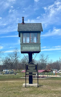
Watchtower, current: (Satellite)
Depot, current: (Satellite)
Watchtower, original: (Satellite, east of Perl St. and between Bender St. and double tracks.)
Depot, original: (Satellite, it is now some NS shanties and a parking lot.)


Ken Durkel posted
X Tower, Knox, Indiana. NKP/NYC Kankakee Belt (Three I) crossing. M.D. McCarter photo collection. Nickel Plate train is eastbound. I believe the track adjacent to the main was a siding that no longer exists.
Brad Johnson What year would this be?
Ken Durkel Not sure, I would say mid 1950s. Adam St Germain would this tower have survived after CTC reached this portion of the NKP?
Adam St Germain I'm not sure how long that tower survived but the siding used to run through town to the east. In the 80s it was cut back to west of where the NYC diamond was to eliminate all the crossings in town. Judging from the signal in the background, the line was already CTC when this photo was taken.
Ken Durkel My 1952 timetable says at Knox, the east end of the westward and the west end of the eastward sidings at Knox were controlled by the Dispatcher Ft. Wayne. So CTC had reached Knox by at least 1952, though I don't think it had been extended completely west to Van Loon by 1952 yet.
Adam St Germain I found a website that states the tower was installed sometime prior to 1906, and made into an automatic interlocking by 1957. The diamond was removed in 1982.

Mark Egebrecht Berkshire!

According to the 2005 SPV Map, there where two "Knox IN" locations. There was this one and another that is not labelled by Google Map. That one was located where the abandoned Big Four track curved north of  Knightstown, IN.

Joseph Tuch Santucci posted six photos with the comment:
All along the watchtower. We’re in Knox, IN at a park at the north end of town at the location where the corner New York Central/Penn Central/Conrail Kankakee Belt Line used to come through town. The tall tower was that of the crossing watchman who controlled crossing signal along the Nickel Plate Road in town. This tower, the old NKP depot and the N&W caboose share their new neighborhood. 
9 December 2023
Dennis DeBruler: Thanks for providing some directions. The city's website was no help in finding "Knox Gateway." https://maps.app.goo.gl/6P5pgm6Yrq5aUGgs9
1

2

3

4

5

6

Street View, Aug 2018

Apr 6, 1969 @ 24,000; AR1VCCF00010180

4 of 8 photos posted by Industrial Belt Railway with the comment: "some of the old Nickel Plate station before it was moved to the edge of town to the park."
1

2

3

4
.
7 of 16 photos posted  by Austin Sasse with the comment: "Spanning the Yellow river in Knox, IN., this former New York Central right if way was once part of the Kankakee Belt Line, originally constructed by the Chicago Indiana & Southern. Immediately SW of the bridge is a small display honoring the towns railroad history." 
Locomotive Jordan: Actually originally part of the 3 - I's, Iowa, Illinois and Indiana Rwy.
a

b

c

d

e

f

g

Sunday, July 26, 2020

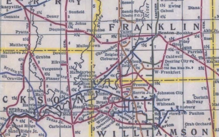
Franklin C: West Frankfort, IL: Orient #1 & #2 Mines

#1: (Satellite)
#2 North: (Satellite?, motor shaft)
#2 South: (Satellite, main shaft)

Scroll down to "Photographs" in ILmines for several photos of Orient #2.

Roger Kujawa posted
Orient No. 1 Coal Mine Franklin County IL Illinois 1939.
Todd Stevens The interstate exit sign used to not say:
West Frankfort
Zeigler
It used to say:
Orient
Zeigler
Roger Kujawa posted again
Franklin County Illinois Orient No 1 Coal Mine 1939 Steam Shovel Mining Plant
[The caption at the LOC link: "Orient No. 1, one of the largest coal mines in the world. Franklin County, Illinois (see 26940-D)"]

David Budka Looks like a small mine-mouth power plant too. I love those little steam or diesel powered self-propelled cranes!

Larry Joe Jenkel posted
Orient #1 Mine Franklin County 1913 - 1955. Last production March 1955. Coal seam 6, 9" - 10" thick. Depth 510" to 520"

Larry Joe Jenkel's post got removed before I got the info. 
Orient #2

Larry Joe Jenkel posted
Larry Joe Jenkel posted again

hinton-gen, this page has several interior shots as well

Larry Joe Jenkel posted
Orient #2 Franklin County, 480 ft to 500 ft depth, 8" to 12.5" thick, 6 seam. 1921 to 1960. Last production was November 30, 1960.
Allen Wilson That is where my dad work when it blew up killing 119 men.
Steven Kent Allen Wilson that disaster set practice at #3. If the barometer dropped to 29.5 inches. The mine was shut down and everyone when home. The gas behind the seals in the old works escapes to the lower pressure area in the return and caused the explosion at #2. Sad that so many men died...
Allen Wilson Steven Kent - dad always said that air pressure was really low. He thought that it was a probability the explosion occurred when a miner snuck into the old works for a smoke.
Steven Kent Allen Wilson that was the speculation. That’s why 29.5 became the standard. The pressure was 29.5 when the disaster at #2 occurred

Larry Joe Jenkel posted

Directory

Directory
 Note that 366 has two tipples marked on the map.
Map

1938 Aerial Photo from ILHAP
Orient #1 is near the top.

1938 Aerial Photo from ILHAP
Orient #2 north of West Frankfort on the west side.

Roger Kujawa posted
Orient No. 2 Bituminous Coal Mine West Frankfort IL Illinois
 
Larry Joe Jenkel posted, cropped
Orient #2 West Frankfort

Courtney Cox posted
Where my grandfather worked…

Larry Joe Jenkel posted
Deb Ragland: On Saturday’s at Orient #6, when they weren’t hoisting coal, we did dead work. They would usually send 4 miners to “clean” the skip shaft. There was forced air blowing down the shaft. In the winter time it was very cold. if it was raining on top, there would be rain coming down the shaft, then you were cold & wet. Plus there was always dust & grit in the air. They would chain a large metal bucket to the bottom of the skip then lower the skip till the bucket was setting on the skip bench at the very bottom of the shaft. Two people shoveled the coal out from around the bench into the bucket then the bucket would be hoisted up to the skip landing where the bucket could be dumped, then the skip was lowered & that coal was shoveled into the skip. Then the skip would be lowered till the bucket was sitting on the bench again. You just kept repeating that till the end of the shift or it was “cleaned” completely. I don’t think I ever seen it “cleaned” completely. I heard a story that one time they had brought miners out of the mine, riding in the skip when the fan (air) went down. I don’t know if that was true or not but it had to be better than climbing all those stairs to the top! lol
Bob Dial: I would have liked to see that when it was in operation. Guys that worked in the mines in Franklin County told me it was a competition to see which mines hoisted the most skips in a shift.

If you Google "orient #2 coal mine", there are several articles about a big mine explosion.

TheSouthern, photo 26 of 27
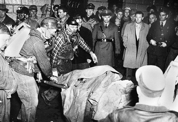
Rescue workers pull a miner worker from the Orient No. 2 coal mine in West Frankfor, Ill., Dec. 22, 1951, following an underground methane explosion. The state legislature passed the Illinois Mining Act of 1953, mandating better ventilation in underground mines and better testing for methane, which investigators said was the cause of the blast.

TheSouthern, photo 27 of 27
A miner is pulled from the C.W. & F. New Orient Mine No. 2 at West Frankfort on Dec. 21, 1951, after a methane explosion 500 feet below the surface. More than half of the 200 men working that night at the Chicago, Wilmington and Franklin Coal mine were killed in what was Illinois' worst coal-mine disaster since 1909 and the worst in the half-century since.

West Frankfort Quadrangle


1928 IDOT Map

IC Map

CB&Q Map

C&EI Map


(This photo was supposed to be near the top. But a Google bug put it at the bottom of these notes. Instead of wasting my time working around a bug that I reported weeks ago, I leave the photo here as a monument to Google's bug.)
David Cantrell posted
Chicago, Wilmington & Franklin Coal Company, Mine No. 2, West Frankfort.
--1931 Chicago and Eastern Railway Official Directory of Industries

TheSouthern

Rescue workers pull a miner worker from the Orient No. 2 coal mine in West Frankfort, Ill., Dec. 22, 1951, following an underground methane explosion. The state legislature passed the Illinois Mining Act of 1953, mandating better ventilation in underground mines and better testing for methane, which investigators said was the cause of the blast.