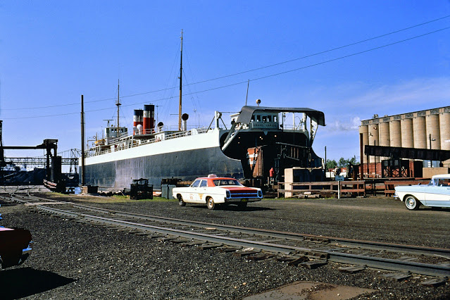
North is to the right. Continental Grain is now COFCO.
 |
| Joe McCarron posted
My collection. GTW. MIlwaukee, WI (anointed for my dad) 1950's. From top, clockwise;
GTW freight house - Also contained business yard office.
Your shack - There were two "shacks" when the engineers stayed. One for the foreman and the other, "your shack", for the engineers.
Roundhouse - It was an engine shed originally build for steam engines, but they called it the "roundhouse".
Swing Bridge - Over the Kinnickinnic river. Used by the Chicago Northwestern RR.
Continental Grain - Also used to be "Stratton Grain", etc. Familiar landmark.
Freddy's shack - The section foreman.
Dennis DeBruler This photo also shows that GTW had two ferry slips. You can still see some remnants: https://www.google.com/.../@43.0114825,-87.../data=!3m1!1e3 Mike Delaney Looks like the usual supply of Pittsburgh Steamship Co. ore carriers parked here for the winter. I would say with lack of ice very late warm December or very early warm spring. Kevin P. Keefe Is the carferry a GTW boat? Looks vaguely like the old Milwaukee Clipper. Seems to be streamlined. Nick Trimberger Did GTW actually service any industries in Milwaukee, or was it solely switch carferries and interchanging? Charles Geletzke Jr.Charles is a moderator in this group. For the answer to that question, Nick, I suggest you obtain a copy of the latest issue of THE SEMAPHORE (Issue #68) put out by the GTWHS. It contains an entire article on GTW operations in Milwaukee, Wisconsin! |
I studied the 2005 SPV Map trying to find GTW tracks in Milwaukee until I finally had the "duh" moment when I realized that this yard was their tracks. It was an interchange yard between the GTW ferries and their freight house and the C&NW. Because all of interchange traffic goes to C&NW, I added the "rrCaNW" label on this post.
Update: Joe McCarron posted two photos with the comment: "My collection. GTW. MIlwaukee, WI."
 |
| 1 |
 |
| 2 |
 |
| Greg Mross posted S.S. Grand Rapids at the GTW dock in Milwaukee, WI. Slide is hand dated 5/71 which may or may not be correct. Most sites say she was out of service in 1970 but a newspaper article says she was stuck in the ice in Feb. of 1971. Either way, it was near the end of her active career. The dock didn't last much longer either as they would switch to the dock on Jones Island in a few years. The Grand Rapids was built in 1926, 1 of 6 built to this design. She was rebuilt in 1967 with a raised deck. After finally being laid up and used for parts, she was eventually towed for scrap in 1989. Russ Porter image from my collection. John Melcher: Yep that dock sat empty or had minimal use after the car ferries. That dock was back filled with material that was excavated from Milwaukee's Deep Tunnel project. They backfilled the outer perimeter to make a coffer dam. In doing that they were able to compact the material as it was being dumped. With the Port losing that carferry dock, they were able to gain the dock that's there now. In my 10 yrs working at Milwaukee Bulk I can't even think of how many tons of limestone I loaded ! I bet it's in the 7 figures?! But once the limestone has been all loaded and the dock is clear , you don't have to dig down far to find where the old dock was. Not to mention a portion of the old tracks are still there. Mike Modderman: John Melcher are you referring to the Jones island dock? This dock in the picture was one of the two GT docks that were up the river a little ways. John Melcher: Mike Modderman yeah I was talking about the Jones Island. Reason being, if you look at the building in the background. It looks almost identical to the MMSD building that is directly adjacent to that dock. I'll have to take another look. Greg Mross: John Melcher Building to the right is Continental Grain. Milwaukee Solvay Coke on the left. |
The 2005 SPV Map is not accurate. It shows all of the ferry routes terminating on the east side of Jones Island. These docks were down on the Kennickinnic River near the bottom center of this topo extract.
 |
| 1958 Milwaukee Quadrangle @ 1:24,000 |
Jack Bobby Lou Mulfreavy posted four photos with the comment: "John Dziobko Jr. images showing the GTW loading a car ferry with a boxcab diesel at Milwaukee"
 |
| 1 |
 |
| 2 |
 |
| 2 |
 |
| 4 |
Robert Strauss posted six photos with the comment: "Railcar ferry Huron in operation circa 1966. SS City of Milwaukee Archives."
 |
| 1 [Fortunately, I noticed the letters "GT" on the ferry so that I could determine this was a GTW ferry.] |
 |
| 2 |
 |
| 3 |
 |
| 4 |
 |
| 5 |
 |
| 6 |
No comments:
Post a Comment