Tuesday, April 20, 2021

Rankin Community, TN: Southern Coal Tower

(Satellite)

Jack Teague posted
The Rankin Tipple aka Coal Tower aka Coal Chute: was built in 1925. The Coaling Station is listed in the National Register of Historic Places. This coaling station was called Leadville Station. Information was taken from Rankin Bottoms Recreation Area web site.
It was one of very few remaining tipples; most were demolished by the railroad companies when diesel replaced steam in the 50s.
Mike Walker shared

Michael Sledjeski via TennesseeRiverValleyGeoTourismYallVisitTheSmokies and EastTNvacations

A feature of this wilderness area is that the river bottoms are allowed to flood several months of the year. I tried using Global Earth to find a satellite image during the Spring or Summer when the bottom lands are flooded. The good news is that it had every year from 1984 to 2020. I've never seen such good coverage. The bad news is that they were all in December, which is probably one of the driest months of the year.

Monday, April 19, 2021

Dayton, OH: 1900 Union Station

(Satellite, In 1964 the depot was torn down to connect 6th St. with Wilkinson St. [libraries.write.edu-later-years])
(Satellite, why would trees grow in just part of the platform area?)

DaytonVistas has a lot of information about these depots.

Ron Tutt posted
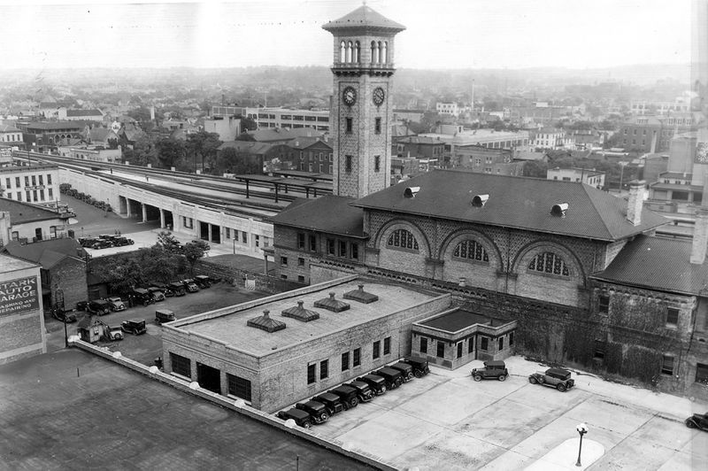
1904. "Union Station -- Dayton, O." In service from 1900 to 1979. 8x10 inch dry plate glass negative, Detroit Photographic Company.

Dennis DeBruler commented on Ron's post
1955 Dayton North & South Quadrangles @ 1:24,000

Dayton Daily News
"During the first 30 years the new station was open, as many as 66 passenger trains served dayton daily."
[The video that has this image has other photos as well.]

Dayton Daily News
[Another video with different photos.]
 
Raymond Storey posted
DAYTON OHIO

The bridge in the background of this photo made it easy to find the station on the topo map. Note the platform canopies in the foreground.
Photo from libraries.wright.edu-early-years

The predecessor 1856 Union Depot was originally built by the Cincinnati, Hamilton & Dayton, a B&O ancestor. 
DaytonVistas and libraries.wright.edu-early years
[The tracks were elevated in the 1930s.]

libraries.write.edu-later-years
[To make way for streets, this depot was replaced by a smaller depot in 1964. The last Amtrak train left in Oct 1979. The 1964 station was removed in 1989.]

Sunday, April 18, 2021

Delphos, OH: Junction: CFER/Pennsy vs. Aban/.../NKP/Cloverleaf

(Satellite)

CFER = Chicago, Fort Wayne & Eastern

Pam Wannemacher posted
Delphos crossing pennsy
Christopher Allen Howe: That's the Pennsy depot on the left and you can barely make out the bay window of the tower next to it by the train.
[The tower was razed in 1985. The tower was in the northwest quadrant of the crossing.]

The multiple east/west tracks are CFER/Pennsy. The rest was NKP/Cloverleaf, but the spoke going South was just an industrial spur. Most of the NKP is gone. I presume what is left is switched by the CFER.
1960 Delphos Quadrangle @ 1:24,000

Pam Wannemacher posted, cropped
Delphos RR tower at PRR/NKP diamond. Top photo taken in 1935, middle photo in mid 50’s, bottom 1976. Notice how tower losing windows through the years.

Jeff Rich posted, cropped
Aerial view of the PRR/NKP Interlocking in Delphos, Ohio Looking South/Southwest with former Cloverleaf buildings and trackage visible including the highly restricted curve as the track looks toward Landeck.

Dennis DeBruler commented on Jeff's post
You can also see the Miami & Erie Canal that went north/south through town.
Jeff Rich: Yes, this little town had it all. PRR Fort Wayne mainline where T1s and the turbine ran, the Nickle Plate, the AC&Y, Ohio Electric Interurban, the Miami & Erie Canal and the Lincoln Highway.
http://www.delphos-ohio.com/Holdg.../interurban_railroad.htm

Matthew Ditton posted
This one is at Delphos, Ohio where the Pennsylvania and Nickel Plate Railroads crossed at one time. The before shot was taken in March of 1983 by Bill Haines of a southbound N&W local crossing the former Pennsy and with the tower still standing. The former NKP tracks this train was on would be removed in 1998 and the former Pennsy is now the Chicago, Fort Wayne and Eastern Railroad . I took the current shot on 4/2/2023 and there are short sections of rail still leading up to the former diamond on both sides. I'm not sure what year the tower was razed but hopefully someone on here will know.
Tim Shanahan shared
Ken Miller commented on Matthew's post
The Southbound signal still stands and is lit up.

The railroad siding is now a driveway for trucks.
Street View, Oct 2016

And turning about 180 degrees I found another elevator isolated by the railroad.
Street View

Galatea, OH: (W) Tower: CSX/B&O vs. CSX/NYC/TOC

(Satellite)

TOC = Toledo & Ohio

Gary Moore posted
[I wonder how many stations the telegraphers had to memorize. "W" for Galatea is not very intuitive.]

Michael Gentis posted
Galatea Ohio interlocking tower Chicago Division B&O railroad
Darren Reynolds posted
B&Os "W" tower..
Galatea, OH.
Bozo Upham: Where the Akron-Chicago main crossed the T&OC (NYC) Western Branch.
Ron Schwiebert: What quadrant was its location?
Bozo Upham: Ron Schwiebert SW of the diamonds per this photo. That’s the I-75 grade in the background.
Darren Reynold posted
B&Os "Galatea" (W) tower, Ohio 1965
Photo by: Bob Mc Cord
Darren Reynolds posted
B&Os "W" tower  Galatea, Ohio
The NYC crossed here..
Ron Schwiebert: Tower sat in the southwest quadrant.
Randall Racine
Duane Thomas: There is a connection track now that is behind where that tower once stood since the North Baltimore inter-model yard was built. And yes behind the truck stop that is there now.
Tim Shanahan shared

Darren Reynolds posted six photos with the comment:
The Baltimore and Ohio Railroads 
"W" tower (West Combo)
Hedgesville, West Virginia
Tim Shanahan shared
1
"W" tower (West Combo) This the 2nd tower at this location..the First tower was Destroyed by fire...this
Was built in 1913 and Destroyed by CSX in Dec. 2000
Photo by: Steve Salamon Sept. 1,1984

2
A brand new SD-50# 8594 and Geep-9 on a Eastbound passing "W" tower (West Combo) on Sept. 1 1984
Photo by: Steve Salamon

3
Looking West at "W" tower (West Combo) the track ahead is the Low grade to "R" tower (Miller) tower...
"W" tower had spiral staircases..
Photo by: Steve Salamon August 19,1984

4
Looking East the track in the distance is the branch that goes to Berkeley junction were it Connect to Conrails
Winchester, Virginia ex Cumberland valley branch on
Sept. 1,1984
Photo by: Steve Salamon

5
A westbound coal train is redy to pass "W" tower (West Combo) on Aug. 19, 1978
Photo by: Steve Salamon

6
On the last days of "W" tower (West Combo) on Oct. 11
2000 and you can see the crossovers are gone ...
"W" tower (West Combo) would be no more.. machine and all.. "W" tower (West Combo) had a GRS 64 leaver interlocking machine.. it closed Nov. 21,2000
Photo by: Eric Powell


Saturday, April 17, 2021

Knox, ND: Grain Elevator Spout across a Road

(Satellite)

Ken Draper posted ten photos with the comment: "In Knox, North Dakota, 4/2/21. Here's a very unusual setup.... two grain elevators that are across the street from each other, but connected by a grain feed pipe! Has anyone else ever seen something like this done?"
John Harker: Transfer spout from one headhouse to the boot pit of the other
Very unique
And somewhat spooky from a repair and patch aspect.
John Harker: Fairly flat angle of repose for small grains other than wheat

Street View

Friday, April 16, 2021

Paducah, KY: PAL/IC North and South Yards

(Satellite)

The roundhouse and backshops were north of the North Yard.

North Yard
3D Satellite

Jim Pearson Photography posted
Signs of Spring at the Paducah and Louisville Railway as CN heads to Fulton, Ky!
With signs of spring in the trees, Canadian National Fulton to Paducah (FUPU) turn heads over the Paducah and Louisville Railway yard as it heads back to Fulton, Ky after making its drop-off and pick-up at Paducah, Ky.
I’ve been trying to catch this shot ever since I got my first drone and it finally happened today, April 3rd, 2021st while myself and fellow railfan Ryan Scott spent the day chasing trains around Paducah and Fulton, Ky! While we didn’t get a lot of trains, what we did catch was nice and you’ll see more in the days to come!
Tech Info: DJI Mavic Air 2 Drone, RAW, 4.5mm (24mm equivalent lens) f/2.8, 1/800, ISO 100.

South Yard
3D Satellite

The building we see on the west side of the North Yard must be a car servicing facility.
3D Satellite

Because down in the "Middle Yard" is an engine servicing facility.
Satellite


Hobart, IN: Pennsy Depot, (HO) and Bart Towers, and Brick Making

(Satellite)

Depot


Street View

Ken Durkel posted
CF&E FWCH passing the historic 110 year old Pennsy Depot in Hobart, Indiana. Now used by Hobart Chamber of Commerce, the building was deeded to Hobart by Conrail in the 1980s and restored inside and out. The depot is on the National Park Service's National Register of Historic Places. Picture taken April 05, 2021.
Mike Stockdale: Those tracks were pulled up at one time . I think around 1997?
Mark Egebrecht: Mike Stockdale The track was out of service from 1991 to 1994, when NS reactivated it up the depot. The rest to Tolleston was reactivated in 1999.

HO Tower


This looks like the Bart tower, but it does have an HO sign on it.
NorthAmericanInterlockings

NorthAmericanInterlockings

Bart Tower


NorthAmericanInterlockings

NorthAmericanInterlockings

NorthAmericanInterlockings

Towers


This is one of those topics that the more I researched it, the more I got confused. It started with trying to determine the location of this tower.
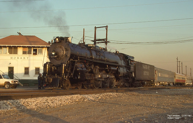
Paul Jansson posted
On 12/20/1991 the much anticipated run of the newly restored ATSF 3751 is seen passing Hobart Tower.
Dennis DeBruler: In which town? It doesn't look like either Bart nor HO in Hobart, IN. Assuming Hobart, IN, is it westbound on the EJ&E and  crossing the Pennsy? [That would mean it was the Bart Tower.]

The 2005 SPV Map indicates Bart is where the Pennsy crossed the EJ&E, and HO is where the Nickel Plate crossed the EJ&E. And the Bart track diagram is consistent with EJ&E crossing Pennsy. But the above NorthAmericanInterlocking photos don't match Paul's photo.
1953/53 Gary and Portage Quads @ 24,000

Digitally Zoomed

This ariel photo shows that both towers where in the northwest quadrant with Bart paralleling Pennsy and HO paralleling EJ&E.
Dec 1, 1951 @ 28,400; AR1PK0000010011

The EJ&E and abandoned; the NKP is now NS; and the Pennsy is now Chicago, Fort Wayne & Eastern Railroad.

Bricks


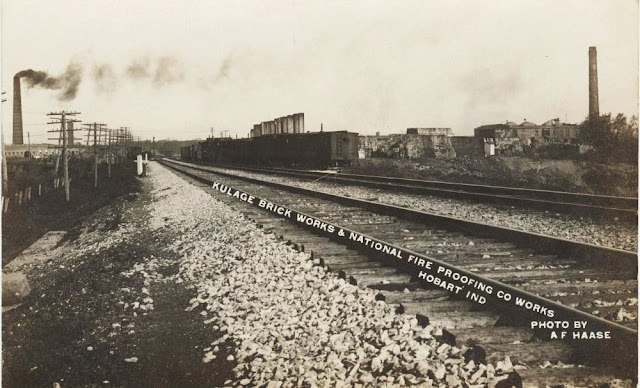
Ken Durkel posted two photos with the comment: "A before and after along today's CF&E ex PRR Ft. Wayne Line in Hobart, Indiana. 1st picture shows the brickyards that lined both sides of the PRR mains, probably taken around 100 years ago. 2nd photo taken August 18, 2021 at the same spot. The last of the brickyards in Hobart closed in 1966."
Thomas Boswell: That's why they are the "Hobart Brickies".
1

2

Dennis DeBruler commented on Ken's post
These topos confirms that the lake north of the Pennsy was the clay pit.
1959 Gary and 1960 Portage Quadrangles @ 1:24,000

Dennis DeBruler commented on Ken's post
Are you looking West from a location that is west of the bridge? This view is looking West from Front St.