Friday, March 7, 2025

Birmingham, MI: Restaurant/GTW Depot

(Satellite)

Street View, Aug 2018

Six photos posted by James Price with the comment: "A recent trip to Michigan led to a 67 mile trip down the Holly Subdivision with stops from Durand to Pontiac,Birmingham, Royal oak , Milwaukee jct,  Dequinder cut, and finally the river.
One highlight was the Birmingham station with a guided interior tour.
Included also is the official end of rail at mp 1.4"
a
Birmingham station under renovation for a new restaurant Mp 17.75 [Mar 2025]

b, cropped

c
Interior of Birmingham station

d
Stairs leading up to passenger platform

e
Top of stairs

f

Moline, IL: Rock Island Natick Railyard and Roundhouse

Roundhouse: (Satellite)
Yard: (Satellite, between 25th and 34th before Silvis Yard was built.)

David Sebben posted
I found this photo today and the caption says it's in East Moline, but probably Silvis in 1902.
Andrew Brown Natick Yard in Moline just west of 34th St., now Midland Steel. The roundhouse still stands.

Fans of Rock Island Lines posted two photos with the comment: "Old natick yard Moline Illinois. Two tracks furthest right are the rocks right of way. RH can be seen behind house on left. To me the walk way for the C.R.& P stations roof line can be seen bottom right of second pic."
[A comment talks about 13th St. and 4th Ave. Other comments gave the location of the Silvis Yard, which I think is wrong.]
1

2, the size was doubled

Fans of Rock Island Lines posted
Probably the best pic of Natick yard in Moline including RH.
Comments on the above post

An 1894 topo map is too old to show the yard.
1894/94 Davenport Quad @ 62,500

And a 1949 map is too new to show the yard. Unfortunately, there are no topo maps between these dates.
1949/49 Davenport Quad @ 24,000

Hudson, OH: Lost/Pennsy Depot and Junction Tower: Pennsy vs. Pennsy

(Satellite)

Darren Reynolds posted three photos with the comment: "Conrails ( Ex-PRR) 
"Hudson" Block and interlocking station 
Hudson, Ohio"
John Penca: Depot too
Jim Kelling shared with the comment: "Hudson Ohio."
Jim Kelling shared with the comment: "Hudson Ohio."
Jeff Pennell: Very nice CTC Board
1
"Hudson" station in Hudson, Ohio with a CTC machine inside...
Photo by : Chip Syme Collection ( No Date)

2
The CTC machine inside of "Hudson" station..Hudson, Ohio
Photo by: Chip Syme Collection ( No Date),

3
A closer look at the CTC machine inside of "Hudson"
Station
Photo by: Chip Syme Collection ( No Date)
John Barnett: I worked there the night Hurricane Hugo, in September 1989 hit Hudson, That board and the tower had some lights, when the entire area was dark due to the storm. The PRR, you have to admire them.

It was obviously in the northern point of the wye.
Apr 21, 1951 @ 17,000; AR1PH0000040183

Thursday, March 6, 2025

St Louis, MO: Wabash 1928 Depot, Delmar Railyard and St. Louis Ave. Tower

Depot: (Satellite)
Delmar Yard: (Satellite, Washington University has used the land for expansion.)
St Louis Ave. Tower: (Satellite, a guess based on some comments on Richard's share below.)
Church Steeples in William's photo below: (Satellite)

I.e. Xam posted
Located in St Louis, Delmar Station, built in 1928 by the Wabash, was about 5 miles from Union Station in downtown. My grandparents lived nearby and used this station regularly.  I remember seeing them off here on occasion.

Street View, Apr 2019

Jeff Wilson posted
Delmar Station, Wabash Railroad, St. Louis

OldTrails
The Delmar Loop MetroLink stop is adjacent to the rear of the former Wabash Railroad Delmar Station, which once handled a substantial amount of that railroad's St. Louis passenger traffic.  Light rail runs underneath the old structure, as did the trains of long ago.
The visiting railfan wonders what must it have been like here, once upon a time.  Old schedules are at first more than a little confusing to one not familiar with the area's rail history.  Outbound Wabash trains for western destinations such as Omaha and Kansas City stopped here, but also so did trains heading to the east for places such as Chicago and Detroit.  Some further research shows that the line used Merchants Bridge, north of downtown, to cross the Mississippi, and trains from eastern destinations executed a fairly long U-shaped route to reach the stub-ended Union Station downtown.   

"Since the night trains to Chicago and Kansas City left about midnight, there were setout sleepers that Delmar patrons could board at a decent time (Unlike going north from Sacramento now), and at one time, there were two sleepers for Chicago from Delmar and only one from Union Station." [Deggesty comment on Trains]

nextstl
Washington University bought the building in 2016.

1954/59 Clayton Quad @ 24,000

The church steeples in the right background and some comments on Richard's share indicated this tower was down by the river.
William A. Shaffer posted
Wabash Tower
St. Louis, MO
(Photographer Unknown - Collection of William A. Shaffer)
Richard Fiedler shared
Tim Shanahan shared

St. Louis Avenue bends, and it is near the bottom of this excerpt. I noticed that the tracks a little east of Broadway are labeled "Wabash."
1954/58 Granite City Quad @ 24,000

Mystery


Where was this depot?
Gary Tetley posted buildings designed by architect Theodore C. Link, FAIA.
"1904 St. Louis MO (Louisiana Purchase Exposition)
"

Louisiana, MO: 1908-1967 GM&O/Chicago & Alton Depot

(Satellite)

Street View, Jul 2023

Jim Butler posted
Chicago-Alton depot Louisiana Missouri
Jerry Nolan: I'm not familiar with the area but Google Earth shows the track going past the station is still used. I wonder who owns that...? 😕
Jim Butler: Jerry Nolan Cpkc
Bill Molony shared
Bill Edrington: Nice shot of one of my favorite depots, although it’s sad to see it in the shape it’s in.

The CB&Q went through town along the river. The C&A passed along the south side after it came off the Mississippi River Bridge.
1940/40 Bowling Green Quad @ 62,500

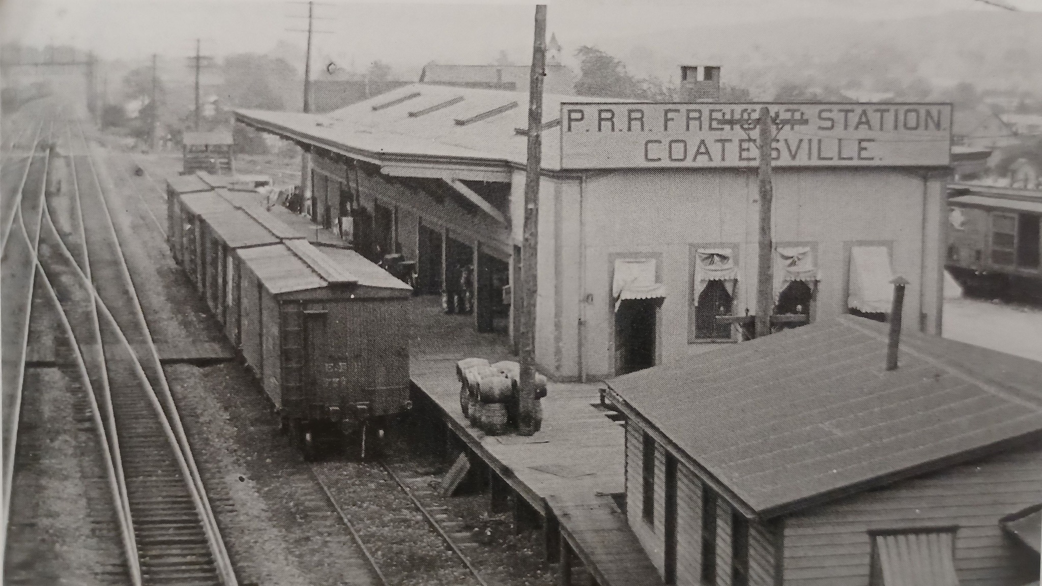
Coatesville, PA: Pennsy (CV) Tower, Freight House & Depot and US-30 Lost/Reading Depot

Tower: (Satellite?)
Freight House: (Satellite?)
Reading Depot: (Satellite, based on Gerry's photo below.)
Pennsy Depot: (Satellite)

This 19th Century image is worth noting even if I could not determine its location.

Metrotrails posted
Historic 1880s view of the Pennsylvania Railroad in Coatesville Pennsylvania, looking westbound, from the Ted Xaras Collection. 
The handsome old CV Tower looks almost like a lighthouse. It was replaced by another structure in 1904 when the entire line was widened to four tracks.
M'ke Helbing shared
Coatesville PA station approach 1880s, Ted Xaras collection

Metrotrails posted
Historic early 1900s of the Pennsylvania Railroad freight station in Coatesville Pa  built in 1904, from Greystone Society.
Metrotrails shared

Gerry Meyle Sr. posted
77 years ago today. Reading Company Coatesville station. June 10, 1948. Paul Hartline photo. U.S. Route 30 crossed here.
Ed Johnson shared

John-Paul Pizzle Fiorentino commented on Gerry's post
This is a google earth view looking north from the crossing in the original shot. You can still see the curbing for the old platform

The number in the overpass is 1911.
Street View, Aug 2021

Charles Crawford posted seven photos with the comment:
Coatesville 1869 PRR station gets new platforms
New passenger platforms and overpass construction at the Coatesville, Chester County Pennsylvania, former 1869 PRR station (still standing). Located at MP 38.45 on the former PRR Main from Philadelphia to Harrisburg, Pittsburgh, and Chicago. Amtrak stops here, SEPTA Philadelphia commuter service is planning to return to serving this stop after being cut back to Downingtown around 1995. Photos by Charles Crawford 10.7.2023
Charles Crawford: At present, ALL SEPTA commuters headed East towards Philadelphia must drive or bus to the Thorndale station, or use Amtrak prices at Parkesburg or Coatesville. A planned sports venue should help, along with expanded parking, the former Lukens steel plant is also served, along with the Coatesville VA Hospital. Coatesville once had the longest covered passenger platforms on the PRR commuter system. Residential building in Western Chester County is constant.
1

2

3

4

5

6

7

Buildings have been removed along the tracks. Probably to make a commuter parking lot.
earth, 2012

The remaining building is gone by 2015.
earth, 2013

The most recent image is 225 and shows the platform construction in progress.
earth, 2025

The Pennsy route is now used by NS and Amtrak. The Reading route is abandoned to the north and operated by East Penn to the south.
rail.guide

The reporting marks for East Penn are ESPN.
National Rail Network Map

regional-rail


Wednesday, March 5, 2025

Thunder Bay, ON: Lost/Saskatchewan Wheat Pool 5 Grain Elevator and Abandoned Fort William Elevator

Pool 5: (Satellite, it was larger along the riverfront than the extant Fort William elevator.)
Fort William: (Satellite)

Marine Historical Society of Detroit posted
Upper Lake's Maunaloa II loading grain at the Saskatchewan Wheat Pool 5 elevator on the Kaministiquia River in Fort William (now Thunder Bay), Ontario.  Unknown date but between 1963 and 1971.  Edward O. Clark photo/MHSD collection.
All three portions of the Pool 5 elevator were demolished in 1980. The elevator to the right, once known as the Fort William Elevator, still stands but is unused.
Kent Rengo shared

Brian R. Wroblewski commented on Kent's share
Maunaloa II being towed up the Buffalo River Entrance Channel by tug Oaklahoma, 1970's era.
[A lot of grain is still shipped from Thunder Bay to Buffalo.]