 |
| Altamont, IL History posted
Altamont wouldn't exist without the railroads. With the building of the Vandalia and Ohio, Chicago and Eastern Illinois, and Mississippi Railroads, Altamont became an economic hub. Pictured below are Altamont's train stations. This area is near the current site of the grain elevators. For years, this area was the epicenter of activity in town with passengers, mail, freight, etc passing through it.
The stations were the site of many interesting stories including one about a group of gypsies. A young gypsy was pregnant and gave birth to a child in the station waiting room. The delivery of the baby became a spectacle. Drapes were set up around the delivering mother and bystanders could pay 25 cents to watch it.
Patrick Zacha This appears to be the old B&O tracks looking straight north just south of the east west tracks of the Penn tracks. |
 |
| Andy Zukowski posted Union Depot and B & O Locomotive # 680 at Altamont, Illinois. The location is really the crossing of Vandalia Railroad and the B&O's Flora, Ill to Springfield, Ill branch off the St Louis - Cincinnati mainline. The branch railroad and locomotive were originally Ohio and MIssissippi RR. No.115 built in 1869 and was rebuilt in 1892. Became B&O Southwestern RR No. 680 in 1893 and became Baltimore & Ohio 680 in 1900. The Locomotive was retired by B&O in 1917. The crossing, station and tower are that of the Vandalia Line which became part of the Pittsburgh, Cincinnati, Chicago & St Louis in 1916 and later is leased (instead of controlled) by the Pennsylvania Railroad in 1920. It was and is the PRR Mainline to St.Louis. |
 |
| Andy Zukowski posted The Vandalia Railroad Depot in Altamont, Illinois, 1912 |
 |
| Andy Zukowski posted The Vandalia Railroad Depot in Altamont Illinois. HH Bregstone, St Louis,Publisher, Postmarked 1915 |
The Chicago & Eastern Illinois had a southern branch off of its western branch that went down into coal country. This southern branch entered Altamont on the north and left on the west. The Baltimore & Ohio had a branch that went north/south through town. The B&O branch must have initially been the Mississippi Railroad mentioned in the caption. Wabash had a branch that came from the northeast and terminated in Altamont.
You can see how the B&O came in from the south on an angle until it crossed 300th St. Then it curved north and went straight through town once it crossed County Road 800 N.
The B&O continued straight north while the C&EI crossed it with a "wiggle" north of Jackson Street.
The B&O paralleled the C&EI until just south of Moccasin where it headed northwest while the C&EI continued north.
I found just a diagonal property line as a remnant of the Wabash route to Altamont. Very little current evidence of the route is consistent with it being abandoned a long time ago by the Wabash. That is, it was abandoned before the N&W merger.
Following that line towards Altamont allowed me to determine that this curved treeline is where the Wabash turned south and joined the C&EI for entry into town.
I used a 1939 historic aerial photo to confirm that the Wabash joined the C&EI where it curved south and then the C&EI crossed the B&O north of Jackson.
The photo below shows how the C&EI used to curve westward and parallel the Pennsy out of town. Now the UP/C&EI curves less sharply and joins the CSX/Pennsy route. You can still see the remnants of the C&EI curve and the parallel route. I find it interesting that the C&EI goes back to its old route at 100th St.
The Prairie Trunk Railway (PARY) was the last owner of the B&O route before it was abandoned.
Altamont is like Chicago in that its Union Station is not really a union station that handled all of the railroads in the town. The Union Station handled the Pennsy and B&O. The C&EI/Wabash had their own depot.
 |
| Satellite |
 |
| Satellite |
 |
| Satellite |
 |
| Satellite |
 |
| Satellite |
| Aerial |
The photo below shows how the C&EI used to curve westward and parallel the Pennsy out of town. Now the UP/C&EI curves less sharply and joins the CSX/Pennsy route. You can still see the remnants of the C&EI curve and the parallel route. I find it interesting that the C&EI goes back to its old route at 100th St.
 |
| 1939 Aerial Photo from ILHAP |
 |
| Altamont, IL History posted
A senior class posing for a photo before departing on their class trip. Late 1950s.
Behind the senior class is the Altamont Depot. The first station was built at this site in 1870. The station changed over the years, but for decades, it was the center of the community. It brought passengers, news, mail, and freight into Altamont everyday.The station was demolished in the 1970s after a steady decline in passenger train usage.
|
 |
| Altamont, IL History shared Today's picture takes us to Altamont, Illinois and the Wabash/C&EI Depot. |
 |
| Andy Zukowski posted The Wabash/Chicago and Eastern Illinois Railroad Depot, Altamont, Illinois. |
 |
| Mike Samuel posted This is a great scene @ Altamont, Illinois Richard Fiedler shared |
In the following closeup of the junction, I put a red rectangle around the C&EI+Wabash depot, a blue rectangle around the PRR+B&O depot and a green rectangle around the junction tower.
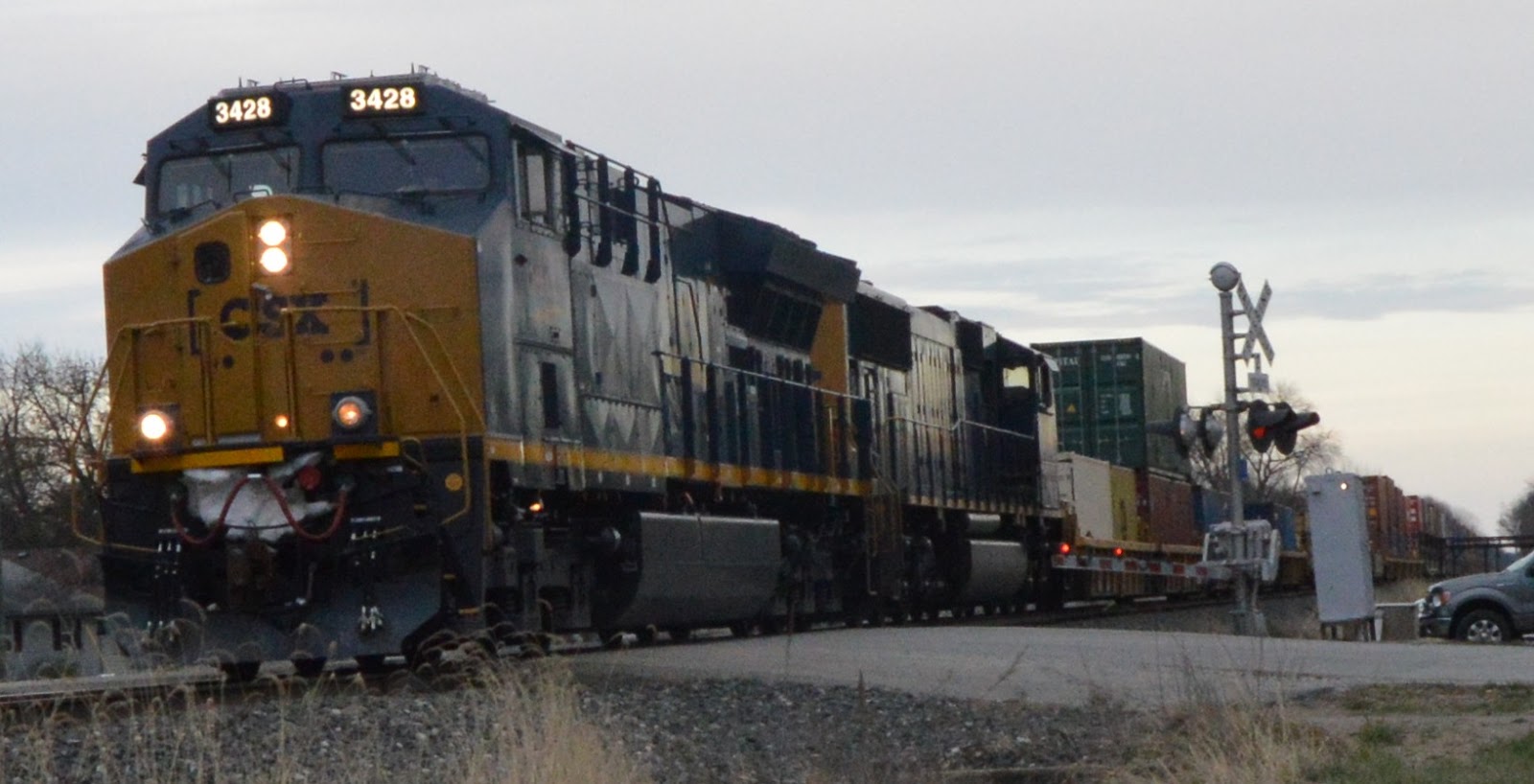
Update: After seeing a covered wood bridge, my GPS routed me over some country roads to get me to my next intended target, a railroad water tank. That routing took me across some railroad tracks. When I saw a headlight to the west, I made a quick right turn and parked to catch the train.
While I was looking west, I heard the crossing gates activate. This surprised me because the train with the headlights was still far away. But then I heard diesel engines behind me so I turned and saw this:
No real railfan is going to take a picture this close to a locomotive. But I'm glad I did because I never noticed before that some of the panels have a slight pyramid shape. I left it as the raw tilted view because that catches most of the front truck. And the tilt emphasis how surprised I was by the appearance of this train.

At this point, I was just grabbing shots to record the locomotive numbers. 3428 is an ET44AH built in 2016. That would explain the high steps with pyramid shaped panels under them. GE had to make more room for all of the Tier 4 stuff they had to add to meet EPA regulations. (EMD has yet to meet them.) 4586 is a SD70MAC built 4-5/98, an ex-Conrail unit. So CSX was putting on a good show of the new and the old for me.

As the intermodal rolled by, I walked further west to get that stupid signalling box out of my way. Even though I was not far enough to get a clear view, I took this shot to capture the meet between the two trains. Note the headlights in the lower-left corner.

I was lucky that the CSX train did not skunk the UP train because it turned north. If I had known the train was going to curve north, I would have walked further west to be closer to it. At least one can tell it was a UP train with two locomotives.

Since it was a mixed freight, I did walk closer as it passed and took some sample shots to get a feel for the consist.


I took this picture as I was walking back to the van to note it had a cut of tank cars as well as hoppers.

After some research when I got back home, this is the C&EI southern branch. This train will proceed north over the Wolf Creek and Shelbyville trestles.
You can tell this town used to be a railroad town, The downtown has four bars within about a block of each other. And, even though it is next to an I-70 exit, it has more bars than gas stations.
A very different exposure.
 |
| 1939 Aerial Photo from ILHAP |
 |
| Effingham County Courthouse Museum Effingham IL posted
Good morning! Today's picture takes us to Altamont, Illinois. This is a depot in Altamont but for which railroad line I don't know. I also see a two-story building that you can see in the background on the left. Perhaps that can help identify which depot this is.
This picture is circa 1940. The railroad lines that ran through Altamont were the Pennsylvania, the C.E.&I, the Chicago and Paducah (later the Wabash), and the Springfield & Ohio (later the Baltimore and Ohio). The only one I think I can rule out is the Pennsylvania.
I'm asking for those of you who are more familiar with the railroads of Effingham County and/or the Altamont area to help me out with this picture. I know the rough location of where this was but not the specific railroad. I confess to getting confused with the large number of railroad lines that used to or still do cross in Effingham County and the subsequent name changes throughout the years. I'm sure many of you will be able to solve this for me and others. I for one would love for someone to write a book on the history of the railroads of Effingham County (complete with pictures!). Any takers?
Wherever you may be, I wish you a wonderful day!
Patrick Zacha This is the C&EI (Chicago and Eastern Illinois) depot. The street in the foreground is Jefferson Avenue. I don't remember when it was torn down but I remember it through all of the 1950's and into the early 60's. To the right or west of the depot building you can see the Penn Tracks that ran west to east. Follow those tracks east behind the depot, you can see the tracks again on the left side of the depot. The three story building is located on the south side of the Penn tracks so it is not the old Altamont Hotel or the current apartment building. I believe I remember being told there was a hotel on the south side of the Penn tracks but west of the B&O tracks which ran north and south and intersected the Penn tracks. There was a Penn Depot on the east side of the B&O tracks but on the south side of the Penn tracks. I believe this hotel in the photo burned down but I down know for sure. The C&EI tracks crossed the B&O north of town as the B&O went north to Beecher City while the C&EI went north and crossed Route 33 east of Beecher City just west of Wolf Creek. The area directly behind the depot today would be the grain elevator operation. My parents, Leo and Ann Zacha, owned the home I grew up in at 704 West Jefferson which is just west of the photo on the south side of Jefferson. The Altamont Hotel in the 50's and 60's was owned by my aunt Rosie Zacha Armstrong. The hotel had rooms upstairs, a large kitchen and dining room Inge first floor along with a parlor area and a bar area. As a child, I remember Penn passenger trains would grab a bag of mail from an arm as they were going west to St. Louis. I remember on time they missed it and the bag went under the train and there was pieces of mail everywhere. The postal worker was picking up pieces for several hours. The intersection of the three railroads brought a lot of traffic to and through the City of Altamont. But it also brought railroad 'bums' or hobos to the area. This is what they were called back then, but they would hitchhike across country rail cars. I remember some coming up to our back door asking for food.Tom Denton I agree, C&EI Depot on the curve. The C%EI came into town from the north and turned west to parrallel the Pennsy. The Pennsylvania is the east west track in the back ground. It's station is to the left (or east) of this picture. The B&O ran north south, parallel to the C&EI before crossing the Pennsy. The diamond was between the Pennsylvania station and this picture. |
Update: After seeing a covered wood bridge, my GPS routed me over some country roads to get me to my next intended target, a railroad water tank. That routing took me across some railroad tracks. When I saw a headlight to the west, I made a quick right turn and parked to catch the train.
While I was looking west, I heard the crossing gates activate. This surprised me because the train with the headlights was still far away. But then I heard diesel engines behind me so I turned and saw this:
 |
| 20170316 8089, 6:10:36pm |

At this point, I was just grabbing shots to record the locomotive numbers. 3428 is an ET44AH built in 2016. That would explain the high steps with pyramid shaped panels under them. GE had to make more room for all of the Tier 4 stuff they had to add to meet EPA regulations. (EMD has yet to meet them.) 4586 is a SD70MAC built 4-5/98, an ex-Conrail unit. So CSX was putting on a good show of the new and the old for me.

As the intermodal rolled by, I walked further west to get that stupid signalling box out of my way. Even though I was not far enough to get a clear view, I took this shot to capture the meet between the two trains. Note the headlights in the lower-left corner.

 |
| 6:11:08pm |
 |
| 6:11:34pm My camera lens flares (starbursts) even more than my eyeballs do. |
I was lucky that the CSX train did not skunk the UP train because it turned north. If I had known the train was going to curve north, I would have walked further west to be closer to it. At least one can tell it was a UP train with two locomotives.

Since it was a mixed freight, I did walk closer as it passed and took some sample shots to get a feel for the consist.


I took this picture as I was walking back to the van to note it had a cut of tank cars as well as hoppers.

After some research when I got back home, this is the C&EI southern branch. This train will proceed north over the Wolf Creek and Shelbyville trestles.
You can tell this town used to be a railroad town, The downtown has four bars within about a block of each other. And, even though it is next to an I-70 exit, it has more bars than gas stations.
 |
| Rick Braggs posted Altamont Illinois. Depo shared by the C&EI and B&O |
A very different exposure.
 |
| Andy Zukowski posted The Chicago & Eastern Illinois Railroad Depot at Altamont, Illinois. 1908 Photo taken by C.R. Childs |
 |
| Effingham County Courthouse Museum Effingham IL posted |
Railroads have economic impact on Effingham County
Altamont was laid out by J.W. Conologue, then surveyed and platted by C.A. Van Allen on July 19, 1870. Conologue was the first superintendent of The Vandalia Railroad and felt the east-west Vandalia intersecting with the north-south Springfield Division of the Ohio and Mississippi railroads was a desirable place to start a town. The first train to run from north to south from Streator to Altamont was June, 29, 1874.
No comments:
Post a Comment