Monday, June 17, 2019

Vicksburg, MS: IC/Yazoo Depot, Turntable & Caboose Design and Historic Riverfront Photos

Depot: (Satellite)  The Lower Mississippi River Museum is just a block away.
Turntable: (Satellite)


George Bolls posted
The Yazoo and Mississippi Valley depot in Vicksburg, MS. The Y&MV was a subsidiary of Illinois Central and was eventually absorbed by IC.
Dennis DeBruler From a bridge posting, I see the MidSouth existed as part of ICG's fire sale in the 1980s. Specifically, it was created in 1986 and bought by KCS in 1994.

Mike Bartels: "IC spun off the Meridian-Shreveport line to MidSouth Rail in 1986. KCS acquired MidSouth in 1994 and sold a 30 percent interest in this route to Norfolk Southern in 2006 to help finance improvements to what is now called the Meridian Speedway. The bridge was opened in 1930, replacing ferries. A new parallel highway bridge opened in 1973, although the rail bridge wasn't closed to motor vehicles until 1998."

Kirk Reynolds commented on George's post
A postcard view, circa 1910, looking northwest.

Kirk Reynolds commented on George's post
Another view, circa 1910, looking west.
Dennis DeBruler commented on George's post
When we were passing by Vicksburg 12/30/2018, we deliberately got off on the exit to see what we could find down by the river. They were doing restoration work when we were there.
Dennis DeBruler commented on George's post
The IC caboose has the little door in the side that seems to be unique to IC. The best theory I have read for the purpose of this door is that it was deemed a safer way for the conductor to lean out and catch train orders.
Kirk Reynolds You are correct, Dennis. When the IC built new cabooses in the 1960s, a longer "porch" at each end of the car was added to give crew members a protected area in which to stand when picking up orders. The MidSouth caboose on display is an example of the newer design.
Dennis DeBruler Kirk Reynolds Thanks for the confirmation.
Dennis DeBruler commented on George's post
Here is my other view of the newer design.
On the same day I learned about IC caboose design, these two posting showed up on my timeline.

Brian Fitch posted three photos with the comment: "The old turntable in V’burg I took several years ago."
Jeff Fuller: That was the turntable that was at Meridian and they moved it to Vicksburg dug the hole got everything ready and somebody got the measurement wrong and the hole was about a foot to small so they had to cut the turntable down to fit I remember turning motors at meridian on it in the 90s
1

2

3

William C. Heirtzier Jr. posted
Vicksburg MS..... ICRR steam and the paddle wheeler Sprague on the riverfront.
Cliff Downey This is most likely a storage line of retired steamers from the mid-1950's. Look closely and you can see the smoke stack and sand dome of a third steam locomotive barely visible along the left side of the photo. Plus, the track they are sitting on has lots of weeds. It is a great photo, but for the sake of historical accuracy folks shouldn't think that is an IC train.
Ron Hill The Sprague was the world's largest steam powered sternwheeler towboat. She was nicknamed Big Mama, and was capable of pushing 56 coal barges at once. In 1907, Sprague set a world's all-time record for towing: 60 barges of coal, weighing 67,307 tons, covering an area of ​6 1⁄2 acres, and measuring 925 feet (282 m) by 312 feet (95 m).[3] She was decommissioned as a towboat in 1948.
George Bolls I like the river and rail them the photographer captured. The Sprague was a beast and the railroads in Mississippi basically started in Vicksburg on what would eventually become an IC line.

This is why the tracks and depot are down by the river.
Pete Zimmerman posted
The Mississippi River circa 1906. Steamboat landing at Vicksburg. Sternwheeler Belle of Calhoun and sidewheeler Belle of the Bends. Detroit Publishing Company glass negative. (unknown photographer)

Steven Mankga posted
Steamboats at the Vicksburg landing.
Lloyd Scott Hardin shared

Christian Boepel posted
Gaffed this capture online of an IC caboose on an unconfirmed train at Indianapolis, IN, in the 1950s.
[Obviously, it has the little doors in the side.]
John DuFrane posted three photos with the comment: "Spotted in Champaign today."
[I now recognize the longer platforms to accommodate side rails for the conductor to lean against.]

1

2

3

Chris Goepel posted, cropped, Facebook resolution
Excerpt from a 1935 IC Vicksburg Division condensed profile (with grease pencil updates to 1938) showing details on the IC Meridian District (ex-Y&MV, née-A&V) at Vicksburg, Mississippi.
Thomas E Lucas I have seen profile charts before. This is the first time I have seen a bridge represented in this manner. The bridge access track is also represented in a manner I haven't seen on a map before, however it is common in industrial drafting, which I have done. Thanz for the posting.

William C. Heirtzler Jr. commented on Chris' post
Chris Goepel Nice! What year is the profile from, William?
William C. Heirtzler Jr. Chris Goepel hello.... dates on lower right corner of each page range from 1923-1931? I have an ICRR locomotive blueprint roster from 1926..... think these both are about same age. Got these from
My grandfather who was a Trainmaster for more than 40 years on the Mississippi Division.

Randall shows that they do build a temporary flood wall between the concrete one and the river bluff when a flood threatens.
Randall Hampton posted
Unknown cabooses in Vicksburg, Mississippi at the old passenger station - March 2016
Eric Domboski: Is the blockade to keep potentially-runaway cabooses in their place?
Randall Hampton: No, this is for flood control. High water on the river was expected, so they were plugging up upper level gaps in levees that they hadn't had to worry about in years. Those old sidings are no longer used south of the station. They didn't want to block the main line until the last minute. Lower levels of the levees get put to work every year.

Randall Hampton shared
A different angle on the Vicksburg MS passenger station, you can clearly see that it's on the wrong side of the temporary floodwall section being assembled. Why they didn't extend the permanent wall to the far end of the station, I have no idea. I don't believe the 2016 flood reached track level, but the forecasted crest was close enough that they had to get ready to close the main line on short notice. The river gets high every spring due to snow melt in the far north, but usually stays well below railroad level.
[I added closeup photos of the two cabooses with comments about their design.]

Randall Hampton posted
Vicksburg MS passenger station   4-15-2017
Moderator
This photo appears to be during high-water conditions. Now a museum.
Randall Hampton: Yes, but not as high as the previous year. I was there two years in a row, around the same time of year.

USACE, May 13, 2011, Public Domain

Screenshot
[The river scenes have no barge traffic. I presume the currents are too strong. I've seen videos showing that it is hard threading a tow under the bridges with just normal currents. At 3:22, it appears that the poor side of the town is not only on the other side of the tracks, but on the other side of the levee. At least most of the homes are on stilts.]


Oct 2022:
Sam Evans Strickland posted
Well, the river done run dry mamma at Vicksburg.
Mike Evans: “Preacher Man’s Saying It’s The End Of Time, And The Mississippi River She’s A Going Dry”......Hank Jr..
Ron Bishop shared
Joe Dwyer: Which river?

Dennis DeBruler commented on Joe's comment
The Mississippi River. This photo posted by George Bolls with the comment "The Yazoo and Mississippi Valley depot in Vicksburg, MS. The Y&MV was a subsidiary of Illinois Central and was eventually absorbed by IC." shows what it is supposed to look like by Vicksburg. The depot in the photo is here:
 https://www.google.com/.../data=!3m1!1e3!4m5!3m4...

Dennis DeBruler commented on Ron's share
This is a textbook example of a photo being worth a thousand words. I've read a lot about the Mississippi River being low, but I would not imagine it was this low if I hadn't seen this photo. That means all of these businesses along the back meander are inaccessible.
https://www.google.com/maps/@32.3856948,-90.8863547,4433m/data=!3m1!1e3
A farmer in southwest Wisconsin has said the basis was down to $1.70 for soybeans in Dubuque, IA, so he is having to haul twice as far to Warren, IL.

Mar 2023: And just a few months later they can worry about flooding again.
USGS

USGS-data

USGS-data after clicking Discharge and Display Median

Sunday, June 16, 2019

Clyman, WI: Clyman Junction: C&NW vs. C&NW

(Satellite)

The 2005 SPV Map calls this Jefferson Junction instead of Clyman Junction.

Mark Llanuza posted
Its June 1983 CNW steam 1385 at Clyman tower Wis [photo collection Mark Llanuza ]

It still has its skip hoist.
William Shapotkin posted
Time for some more of those undated/uncredited/unidentified C&NW slides. In this case, believe we are looking at a W/B frt passing under the coaling tower located just east of Clyman Jct, WI. View looks east. (3-72)

Back when it had a wood coal tower.
Jerry Wieland posted
Postcard scene at Clyman Junction, Wisconsin looking west. Dated 8-3-12.
Ray Peacock: Right after it became a through route.

1 of 18 photos posted by Bryan Much
John Bjorkland photo.
https://www.pinterest.com/pin/307792955777065111/
 
William Shapotkin posted
Time for some more of those undated/uncredited/unidentified C&NW slides. If there is a name on either the depot or the tower, I am unable to read same. Might anyone be able to identify the location? (3-32)
Stephen Karlson: The view looking east from the coaling tower that still stands?
John Richmond: Clyman Jct., perhaps before the double track was removed (between Butler and Clyman Jct.), which would have been late 1950s. Both sets of tracks look well-used and shiny. After Ben Heinemann took over, lots of double track disappeared, e.g., the New Line from Gurnee (except that I seem to recall that it wasn't always called Gurnee in the timetable) to Airport Jct., and nearly all of the line from Madison to Elroy.
William Shapotkin posted
Recently acquired a large number of undated/uncredited/unidentified C&NW slides. As it turns out (courtesy of another facebook page), have the location of these two photos. We are are Clyman Jct, WI. Photo 1 looks west. Photo 2 (I do believe) looks geographic north. Might anyone have any clue as to the approx date(s) of these two photos? (3-32 and 3-34)
Jim Kelling shared
Clyman Junction, Wisconsin (C&NW depot)

William commented on the second post
Here is a track map (dated March 23, 1971) of the area:

Craig Holmberg commented on William's post
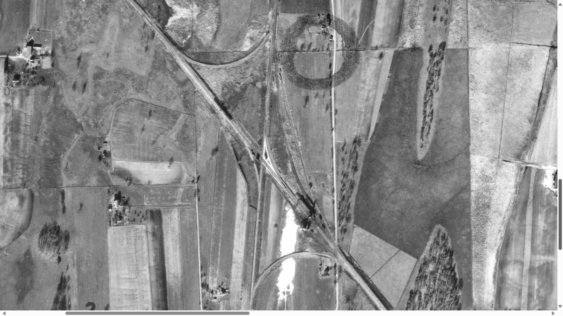
11/6/1940 Aerial photo

Craig Holmberg commented on John's comment
7/4/64 Aerial photo

Craig Holmberg commented on John's comment
3/23/71 Track Profile

Craig Holmberg commented on William's post
Track Profile 3/1/59

William Shapotkin posted
Time for some more of those undated/uncredited/unidentified C&NW slides. Should have spotting this location sooner, as an examination of this slide indicates that we are at Clyman Jct, WI (same location as my earlier posting of slides 3-32 and 3-34). We are looking west (toward Clyman Jct) from a point east of the coaling tower.  (3-33)
Mark Ratzer: Clyman Junction WI. You can see the tower and station in the distance behind the coal dock. Looking westbound.
Dennis DeBruler: This is the first photo I have seen that shows what the skip hoist looked like.

Note the coaling tower in the background.
Joe Holman posted
CNW Train 495, Clyman Jct WI, August 25, 1974 -- We are at the crossing diamond at Clyman Jct as train 495 comes west with GP35 slug set 835-BU37-853 and 42 cars. The diamond was the crossing of the Butler-Adams Adams Subdivision and the Janesville-Fond du lac Janesville Subdivision. Today in 2019, the Adams Sub remains, but the diamond is gone and a remnant of the Janesville Sub (now the Clyman Sub) continues in existence south to Fort Atkinson. Train 495 in the 1970's ran west all the way across Minnesota and South Dakota to Rapid City. Joe Holman photo.
Dennis DeBruler https://www.google.com/.../@43.3250938,-88.../data=!3m1!1e3
The tower in the background at Clyman Jct. looks like the same design as the tower at Nelson, IL.
Dennis DeBruler commented on Joe's post
The coaling tower is of interest to me. Looking at a satellite image, it appears it has been removed. But this photo teaches me that the one at Nelson, IL must have had a tower on top.
https://www.google.com/maps/@41.7971338,-88.0096135,111a,35y,180h,39.43t/data=!3m1!1e3

Now knowing it exists, I took another look. It was closer to the junction than I had thought.
https://www.google.com/.../@43.32362,-88.../data=!3m1!1e3

Justin Kreklow posted
UP CARES train pauses briefly at Clyman Jct WI before heading back to Butler June 2012
Dennis DeBruler A nice view of the coaling tower.

Justin Kreklow posted
Weston coal empties pass underneath the former C&NW coaling tower at Clyman Jct WI 1/2013

Darren Reynolds posted five photos with the comment:
Chicago and North Western Railroads
"Clyman Jct." tower 
Clyman, Wisconsin
1

2

3

4

5

Saturday, June 15, 2019

Elgin, IL: C&NW East Elgin Depot

(Satellite)

C&NW had two depots in Elgin. The West Elgin Depot was on the original G&CU mainline after it crossed the Fox River whereas the East Elgin Depot was on the Lake Geneva Line. That branch left the mainline in the south part of Elgin at the Fox River Switch.

Comments concerning a photo of a 1950 steam excursion train in Elgin indicated that the East Elgin Depot was just a little further north along the Lake Geneva Line.

David Schnell commented on Bill's share below

American-Rails.com posted
Chicago & North Western 4-6-2 #1608 (E) passes the Hotel Fox in downtown Elgin, Illinois, circa 1950's. Photographer unknown.
Bill Molony shared

Andy Zukowski posted
Chicago & North Western Railroad Station in Elgin, Illinois. 1912
Mark Paulson: CNW had three depots in Elgin -- a small "commuter" stop on National Avenue that still stands today on the Williams Bay line; a larger depot about one mile north in downtown Elgin [this one]; and the West Elgin depot that stood about one block west of the Fox River on the Pumpkin Vine route to Rockford and Freeport.
The West Elgin depot was an Italiante structure in design, and looked nothing like the other two depots.

The red rectangle is around the depot and the yellow rectangle is around the Hotel Fox.
1939 Aerial Photo from ILHAP

David Schnell commented on Bill's share

David Schnell commented on Bill's share

David Schnell commented on Bill's share

David Schnell commented on Bill's share
Once again, the topo maps provide more confusion than clarity. It shows neither the depot or Hotel Fox.


Thursday, June 13, 2019

Brewster, MN: Grain Elevator "Fire"

(Satellite)

Back in 1928, the railroad was owned by C&NW. I don't know if it is now owned by UP or a shortline.

I put "fire" in quotes because grain elevators don't have the type of fires that we, and fire departments, are used to seeing such as when a house burns. They have either suspended-grain-dust explosions or smoldering grain. I really wish Facebook still allowed me to get the link for a share because Bob's comments are more knowledgeable than those of the Fire Chief in the shared news article.

Marc Mcclure's share in Grain Elevators of North America on 6/13/2019
Street View
"It isn’t known how the fire started, Garmer said. The bin contained just 20% of its 75,000-bushel capacity." [dGlobe] Someone needs to teach Garmer, the fire chief, about the problems of storing grain that was too wet. Grain elevators are neurotic about making the grain dry enough for safe storage. Every truck load of grain brought to the elevator will be measured for moisture content. And the higher the moisture, the less the farmer will get paid because the elevator has to use more gas to dry the grain. The street view to the right shows the grain dryer and the extra leg to support the dryer that this grain elevator has.
Premier Crop Services posted
That’s one way to dry this wet corn!
[This is an update that shows a bin can have an open flame.]
Rochale Schriner Where’s this at?Mark Viets A friend says it is a canola bin somewhere near him in Canadia.Kyle Long No up in Larue Ohio.Larry Hanshaw Holy shit and i thought we had a bad bin fire.

The Farmer's Life sharedBetter core that bin in the morning. Starting to get a bit warm in the center.

Christian Kimmel commented on Premier Crop Services' post
Fast way to dry out wheat as well lol
Will Addis Christian Kimmel covered under insurance?
Christian Kimmel Will Addis not enough damage. Believe it or not only loss was the contents in the dryer. Got it drained out fast enough.


Kathleen Riley-Daniels, Nov 2017
Marc Mcclure's share in Grain Elevators of North America on 6/13/2019

alex wildfeuer, Aug 2018

Monday, June 10, 2019

Oswego, IL: Grain Elevators

(see below for satellite)

When I drove through Oswego, IL, I deliberately turned off US-34 and followed the Illinois Railway tracks through town to see if I could find some old railroad-oriented buildings. I'm glad I took the side trip because I found two former grain elevators and probably a warehouse. I was focused on the wood elevator in the middle when I took my photos because it was in pretty good shape considering how old it had to be. It also has a design that I don't remember seeing before.

20150720 3515

The galvanized bin next to the blue bins has the highest height-to-diameter ratio I remember seeing.


Satellite
Since I took these photos, I learned from Bob Summers that bolted or welded steel bins were a cheaper alternative to slip-form concrete silos for a fireproof design. The blue silos appear to be an example of welded steel bins.

Street View

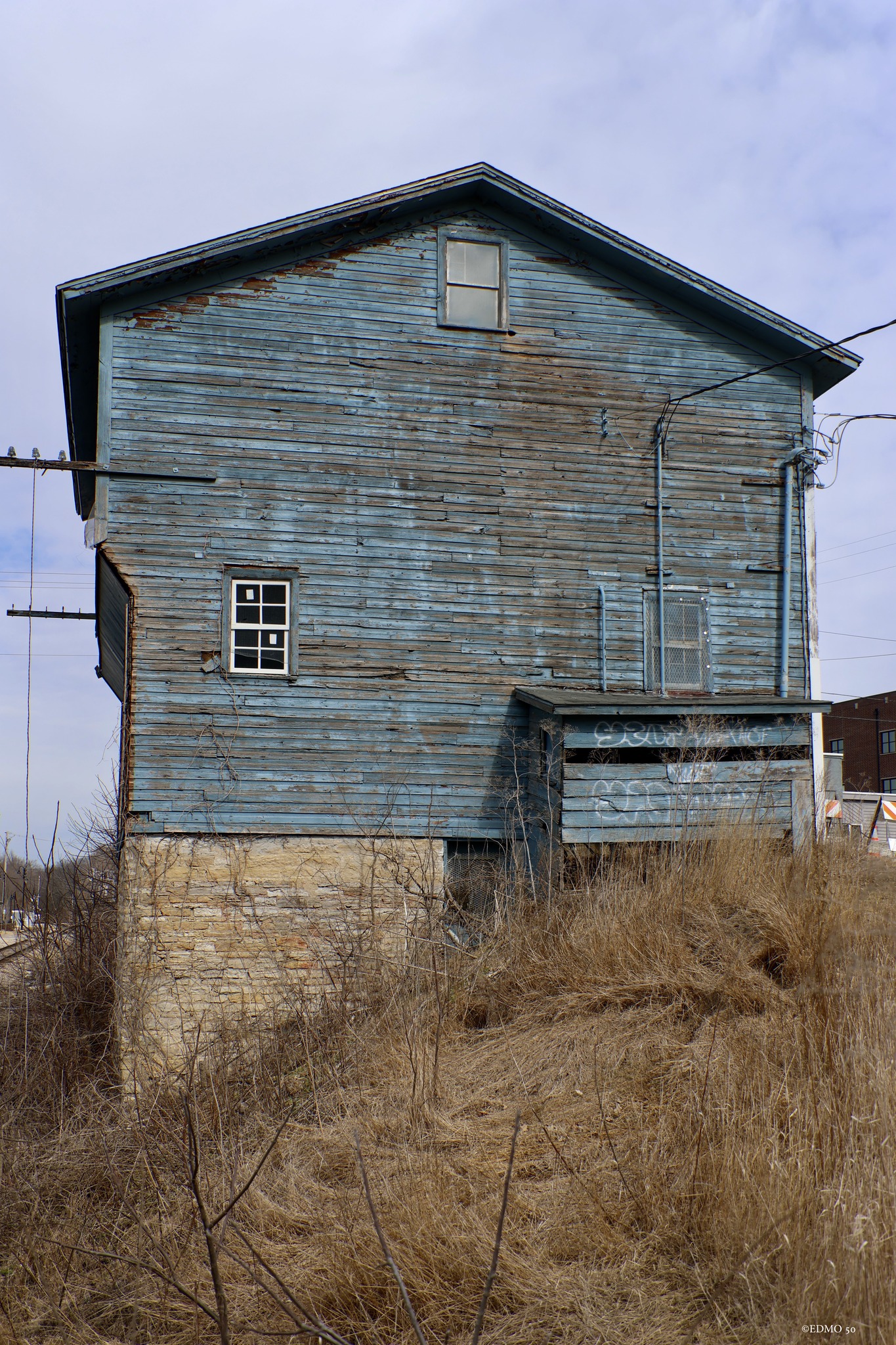
Chuck Edmonson posted four photos with the comment: "Probably built around the turn of the century. this old grain elevator and associated building, once serviced by the CB&Q railroad still stands along Adams St. in Oswego. An old interurban 'doodlebug' that once serviced the town at the nearby station."
1

2

3

4