Thursday, March 22, 2018

Olney, IL: Aban/EVTL/ICG/IC/PD&E Street Running

(Satellite, it was on Kitchell Street between North and Butler Streets)

EVTL = Evansville Terminal Railroad

The IC depot was in the northeast quadrant of Butler Street and Kitchell Ave.

I was surprised to see street running because I have checked out the remnant of the Peoria, Decatur & Evansville between CSX/B&O and the CBB Grain Elevator during several trips that I had made to Evansville. And there was no street running in that stretch. But looking at the abandoned segment of the PD&E north of the CSX/B&O, it makes sense that it ran on Kitchell Street between North and Butler Streets.

Richard Koenig posted
Street Running in Olney, Illinois
Illinois Central line to Evansville, Indiana
We've got a GP18, with factory slant-nose, up front
One image by Richard Koenig; taken mid- to late-1970s
Kam Miller Back when the line still ran, I was in Olney at night while it was snowing. Just beyond the Elks there, the street portion ends and the tracks are above the roadway. I rode right up the tracks, with a train coming. Fortunately, the Elks was in session and they all poured out to help lift my car (A Duster) off the tracks.
Richard Koenig commented on a post
First factory low noses by EMD I believe; love the one-piece windshield.
Richard Koenig posted
Olney, Illinois—this was taken along the Illinois Central between Mattoon, Illinois, and Evansville, Indiana. That's a low-nose GP18 on point. Image by Richard Koenig; taken 1980.

A street view does show that the center of the road has a different "pavement history" than the sides of the road.
Street View
1938 Aerial Photo from ILHAP

Dennis DeBruler posted about the street running.

Chenoa, IL: Prairie Central Coop Grain Elevator

(This construction hasn't shown up yet on a satellite image. Mar 2020 Update: Satellite)

David Jordan posted two photos with the comment:
No wonder I didn't see that TP&W westbound road freight...it turned out to be the Indiana Local tying up at Gilman for the night. I drove to Chenoa then headed back west toward home. But the trip wasn't wasted. I took these views of the new Prairie Central Coop elevator and rail loop between Meadows and Chenoa. Looks like the elevator is nearly complete while part of the loop has been laid.
Dennis DeBruler I asked another group [source]: the crane is a Manitowoc 2250, 300 tons. I'm amazed how big steel bins have become. I wonder what the bushel capacity of that bin is.
1

2

Prairie Central Co-op decided to go with steel bins for their new elevator. The initial capacity is 2.6 million bushels and it will accept just corn. It will take a couple of years before it shows up on satellite images. Compared to elevators that I looked at along the CN/IC of 2, 4, and 8 million bushels; 2.6 is rather small. But with a rail loop and plenty of land, perhaps they intend to significantly grow this elevator.
PontiacDailyLeader, cropped

I learned of the above newspaper article from a Lucas Irons posting:
BIG expansion in little Chenoa Illinois. The country elevator that David Jordan was referring too. I assume the TP&W will be taking this grain in multple directions? This is Prairie States brand new elevator.
David Jordan When construction started, talk was that TP&W would originate grain trains for CSX destinations. Now I'm thinking corn will go to NS destinations (via East Peoria). The elevator might ship to area processors such as Incobrasa Industries at Gilman, ADM at Peoria and Pacific Ethanol at Pekin.
Lukas Irons Will this new elevator at Chenoa affect nearby elevators on the TP&W?
David Jordan Lukas Irons It will probably replace some, if not all, shipments from the other TP&W-served Prairie Central Coop elevators at MeadowsWeston and Fairbury.
Dennis DeBruler: I received the following comment on my blog:

As someone who lives 4 miles away from the new elevator and have been to all and own some shares of PC Co-op, i can safely say: They are keeping all their Railway Accessible elevators. Meadows has become a bean only elevator, the new one is corn only. Weston is kept too, for one its one of the largest and has much room for expansion and it is also one of the two original elevators that merged to form PC. Fairbury is getting more business after PC closed McDowell and tore it down, and now they have torn down the old Chenoa in town. They filed Wind Damage Claims on both, made a lot of money from doing so, and tore them down.
David Jordan: Dennis DeBruler I noticed Incobrasa cars at the Weston elevator Dec. 31.
David Jordan: Back in summer 2020, 90-car unit trains were being loaded here and at the recently-rebuilt Grainland Coop elevator at Cruger on a weekly basis using CSX power and cars. Wind turbine components trains were being unloaded at the Chenoa facility as well. Very busy time!

Dennis DeBruler commented on David's comment
A satellite image caught a unit train of blades being unloaded.

Agrinews-pubs, provided (source)
Prairie Central Cooperative’s new 2.6-million-bushel elevator and rail-loading facility will be open for the 2018 harvest. The elevator was designed with efficiency in mind to keep truck downtime at a minimum. There is 8,000 feet of rail track circled to the east that’s designed to hold up to 120 cars.
Dennis DeBruler 2.6 million bushels is not big, but three truck dumping lanes is. I'm sure the farmers appreciate an elevator that is designed to minimize waiting in line during their busy harvest season.

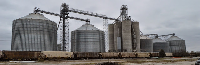
The line was so big at the CGB elevator in Olney, IL that I could not capture it in a photo. The line in the foreground goes a ways to the left and curves around as the two trucks we see to the left of the blue trailer.

Dennis DeBruler Building with just two big storage bins rather than a bunch of smaller silos is a testament to herbicides and modern combines. Grain used to be graded and one of the criteria was the cleanliness of the grain. Several different bins were needed to store several different grades. Also, the Midwest used to grow wheat, oats, and barley instead of just corn and beans. I wonder if this elevator is just corn and they will use their older elevators for beans.


Dennis DeBruler To be fair to CGB, it occurred to me that this lineup of trucks was in Nov. 2014. That was the first year of the big bumper crops and storage was full. You could still see corn standing in the fields in November. CSX had cobbled together a grain train from any old hopper that they could find. While they were loading that train, CGB must have gotten the word out to farmers that they had some more storage room. So the farmers waiting in this line were not busy harvesting. They were removing grain from their own bins so that they could do more harvesting.
Dennis DeBruler To be fair to CSX, on a Dec 11, 2014 visit, a CSX train had just new cars. On that trip, I saw just one field that still had corn in it.

David Jordan posted three photos with the comment:
Sunday [Oct 21, 2018], I checked Prairie Central Co-op's new Chenoa elevator for the first time since it went into operation. First view looks west from the 900 E. crossing. Second view looks southwest from 900 N. The third view, which shows the mainline-to-rail loop connection, looks east (note I-55 bridge) from County Road 2550 E crossing. Hopefully, TP&W will get a lot of corn and soybeans loaded here for many years to come.
Joshua Sheehan I have to wonder if loading at Fairbury, Weston and Meadows will be greatly reduced..
David Jordan Joshua Sheehan I expect it to be eliminated, at least at Weston and Meadows. Of course, track conditions are poor at Fairbury, so that might cease as well.
Josh Clark Do you think any NS grain trains will pay visit to the TPW this season?
David Jordan Josh Clark I understand the track expansion was for NS grain trains, so hopefully, we'll see them more often in the near future.


1

2

3

Sam Carlson posted
April 17, 1981 at Chenoa, IL

Dennis DeBruler commented on Sam's post
I like railfan photos because some of them also teach me about the history of grain elevators. I believe the elevator in this photo is the building just north of the TP&W tracks on the right side of this 1940 aerial. There appears to be another elevator across the tracks from Scott Street.
https://clearinghouse.isgs.illinois.edu/webdocs/ilhap/county/data/mclean/flight1/000x1a017.jpg

The wood grain elevators are gone, but there is another elevator south of the junction.
Satellite


Wednesday, March 21, 2018

EVWR/CSX/L&N/St. Louis & Southeastern and Big4(Egyptian Line) Depot

(Satellite) It is not even a parking lot, just "brown" land.

EVWR = Evansville & Western Railway

Rex Settlemoir posted
Carmi, Illinois (MP 157.8 on the Cairo Line) qualified as a "Union Station" of sorts. The Big 4 used L & N trackage rights for about a mile through town, while both NYC/Big 4 and L & N passenger trains stopped at the L & N depot there. The Big 4 line is abandoned, but L & N trackage through Carmi remains in operation by the Evansville Western short line. The depot is gone, signals are shut down and CSX severed the line short of East St. Louis before selling it to the short line. In my 2007 photo looking South, the unused train order signal still stands at the depot site and looking North, the (dark) signal bridge still stands. The L & N line here originally ran from Evansville, Indiana to St. Louis. The Big 4 had a 137 car siding at Carmi, just South of the depot. Norfolk Southern later acquired the line from Mt. Carmel to Karnak, Illinois and tore it out in 1993.
Art Wallis I have to question the statement regarding the NC&StL, with due respect. The L&N in these parts was the former St. Louis & Southeastern. The NC&StL did not cross into Illinois from Kentucky.
Rex Settlemoir I think you're right about the background of this line. I have a 1953 copy of the Official Guide, which still shows the NC & StL as a separate listing from the L & N -- the "NC" didn't come further north than Paducah, Kentucky. However, to set the record straight, this particular line through Carmi didn't cross from Kentucky to Illinois, it crossed from Indiana to Illinois via the Wabash River!
1938 Aerial Photo from ILHAP

Tuesday, March 20, 2018

Pekin, IL: Aban/CR/Big4/Peoria & Eastern and Santa Fe Yard

(See below for satellite information)

The Santa Fe Depot was on the north side of the yard and west of Capital Street.
The Santa Fe East Yard was further east in town.
The yard covered the three blocks between 2nd and 4th Streets north of the Pekin Park District Trail (Peoria Trail Extension) and south of the alley south of Caroline Street.

Satellite

Santa Fe used to parallel the P&E into downtown until it acquired trackage rights on the P&E and pulled up their track in the Spring of 1969 west of the East Yard Tower. [Harold and David comments on a posting by Roger]

Update:
Richard Fiedler commented on a posting
Alex Timmerman posted this map of the branch a while back

Paul D. Tincher commented on a post
Downtown Pekin also. Found on the internet, not sure who took it.
[Note the caboose for the local in the background.]

Paul D. Tincher commented on a post
Taken in the same yard by me as a kid. I thought it interesting that a P&E boxcar was in Pekin A) still in PC paint (well, this was around ‘77-‘78, so not that unusual) and B ) in a yard that was connected to the former P&E! My grandfather worked for the P&E back in the 50’s-early 60’s.

This needs some more research.
Dana Skyye commented on a post
Pekin tower (left edge of photo) was just west of 2nd St is where the P&E joined the P&PU main and CTC to Peoria


Sunday, March 18, 2018

Michigan City, IN: 10th Street Tower: Amtrak/MC+Aban/Monon vs South Shore

(Satellite)  I knew that the South Shore does street running in Michigan City. Now I know it is on 10th Street on the west side and 11th Street on the east side.
The treeline to the north in the satellite image would have been where the Monon ran next to the MC into town.

Ken Durkel commented on James' posting (below)
James Boudreaux posted
Michigan City...Date,photographer unknown
Ken Durkel: Looks like it was shot from 10th St. Tower. The two tracks to our right are the Michigan Central, which was single tracked in the early 1960s, and today is owned by Amtrak from Porter, Indiana into Michigan. The track crossing from left to right is the South Shore. Train is northbound.
According to a 1961 aerial photo, the area north of 8th Street and west of Wabash was industry. And their freight house was up by Trail Creek. That would explain why Monon was headed north of 10th with several freight cars. Most of Monon's terminal track was south of 10th Street including Moore's Auto Repair on down to south of Garfield and west of Ohio.


Monee, IL: IC Facilities before the cut

Views after the cut was made

Bill Molony posted
The original Illinois Central depot at Monee, Illinois.
Wayne Parker Must've been taken prior to 1926 before the "cut" was done in an effort to save on coal/water costs for all the steam engines. The tracks were lowered above 20-25 feet through that area so the trip through there would be more level (no grades).
Susan Paul Where in Monee?
Wayne Parker Running parallel to Oak St.

Bill Molony posted
The original Illinois Central depot in Monee was constructed in 1853 and remained until 1923 when it was removed to make way for the Monee Cut project.
Bill commented on his post
This 1873 map of Monee shows the location of the original Illinois Central depot.


James Boudreaux posted three photos with the comment: "Illinois Central Depot in Monee,IL. Engine #1906 with remarks of picture year 1905. All prior to the ROW elevation cut."
1

2

3

A better version of Photo 3.
Andy Zukowski posted
Illinois Central Railroad Scene in Monee, Illinois. C1910  
Photo by CU Williams

Andy Zukowski posted
Illinois Central Railroad Depot in Monee, Illinois. 1908
Dan Hawtree: Monee is the peak of the glacial moraine, which is a semi-circle running around the bottom of Lake Michigan.
In steam locomotive days, you could see by the exhaust/smoke how the engine(s) was/were laboring up the incline, even after the cut was made.
Richard Fiedler shared

Larry Candilias commented on Andy's post
 The cut was made in 1923 with all the dirt being taken nort for the ongoing track elevation from Richton Park north. Here's a 1945 track chart showing the grade that was still there and how they just scalped the top off in Monee.


Saturday, March 17, 2018

Indianapolis, IN: IJ Tower: Big4 vs. Big4

(Satellite)

Richard Koenig posted three photos with the comment:
Eastbound train (with SP/Cotton Belt power) on the former Penn Central/NYC at IJ Tower (just west of downtown Indianapolis). I was fifteen when I took these pictures—and clearly standing too close to the tracks. Three images by Richard Koenig; taken January 24th 1976.
Eric Powell Actually west side of downtown - just west of the White River, where the Big Four’s Illinois and Indiana Divisions split. One of the best IJ images I’ve seen, Richard!
Richard Koenig Shoot, I knew that—thanks for the correction. The B&O shared tracks in there somehow as well. Thanks for the compliment and input Eric.
1
2


3

Richard Koenig posted two photos with the comment:
Baltimore & Ohio at IJ Tower
Here is an eastbound train on the B&O through Indianapolis. The job is seen approaching the tower, and then continuing on where it merges onto the former Big Four/New York Central/Penn Central/Conrail line; it will soon cross over the White River.
This combined trackage will take the train through Union Station, the location of which is marked by the clock tower toward the left-hand side of the second image. One may note that there’s a nice little covered wagon of Western Maryland ilk tucked into the consist.
Two images by 
Richard Koenig
; taken June 5th 1976.

James Demaster: The train had to pass by IU Tower. I worked there many years 

1
Image by Richard Koenig

2
Image by Richard Koenig

Richard commented on his post

Darren Reynolds posted five photos with the comment:
Conrails "IJ" tower (EX- NYC/CCC&StL)
Indianapolis, Indiana
This tower is no longer standing
Tim Shanahan shared
1

2

3

4

5