Tuesday, December 27, 2022

Humboldt, NE: CB&Q Depot and Grain Elevators

(Satellite)

Beatrice Area Railroad Enthusiasts posted
Mike Bartels: There was a brickyard in Humboldt that made platform bricks for many CB&Q depots.

I think the depot was near the northwest quadrant of Nemaha Street and the tracks.
1965 Humboldt Quad @ 24,000

There is a long siding to the east of town, but I don't think any of the elevators are rail served because I could not find any fall protectors.
Street View, Aug 2008

Looking the other way, we see that a wood elevator has survived.
Street View, Aug 2008

In the first street view above, I noticed a conveyor over the mainline of the BNSF. It is rare for a railroad to allow a conveyor to be installed over their mainline so I took a closer look. There is a truck unloading platform on the south side. But I was confused by what was over the tracks. So...
Satellite

...I took a closer view from the street. The resolution is limited, but I can see there is a downspout that comes from the tall leg down to the south side of a conveyor. And grain is transferred from the the unloading facility to the north side, which looks like it is (was?) a plant. Even though the town has what looks like distinct elevators, Google Maps has just the label of "Southeast Nebraska Co-Op Co."
Street View

Tom McLaughlin Flickr, 2011
A flour mill was established in 1879. They diversified into mixed feeds. Their original building was over by the depot. This facility was built in 1944. In 1980, Central Soya bought the feed company. Note the blueish wood elevator. It is still standing in the above satellite image. Please access the link for a more complete history of this mill.

After doing a Google search, I came across the names "Wilhelm Grain" and "Humboldt Grain and Flour Company Elevator." Tom McLaughlin further explains that the plant was a flour and feed mill.

I presume these elevators were the Wilhelm Grain Co. And that all of the storage facilities in this town are now owned by the afore mentioned Southeast Nebraska Co-Op. I can't tell how many of the facilities are still being used.
Satellite

Neither of the wood elevators that are still standing are the ones in the photo at the top of these notes.

Supposedly, Andersons owned an elevator in this town because Tyson Foods bought it. Tyson Foods plans (Feb 2018) to build a "chicken complex" in Humboldt. [MilanMirrorExchange] I wonder if that plan happened because a Google search of "tyson chicken nebraska" shows three locations in Nebraska, but none of them are near Humboldt.


Monday, December 26, 2022

Louisville, KY: GE Appliances Plants

(Satellite)

"GE Appliances, a Haier company, plans a $62 million investment to expand production at its massive, 750-acre manufacturing complex in Louisville, Kentucky. The project is expected to create 260 new jobs as each of the three major manufacturing plants at Appliance Park ramp up assembly lines to produce more washers, dryers, dishwashers and refrigerators....Since 2017, GE Appliances has invested $360 million in Appliance Park and has expanded its workforce through the creation of more than 660 new jobs. GEA operations in Kentucky generate an annual economic impact of $11 billion. There are more than 6,500 employees who work for the company in the Louisville area." [AreaDevelopment] (source)

The Appliance Park did not exist on a 1951 topo. The next available topo, 1955, has it and the industrial spurs going North to NS/Southern and South then West to CSX/L&N.
1955 Louisville East Quadrangle @ 1:24,000

GEappliances-our-company


GEappliances

Jacob Montaigne posted
Anyone know what this banner says exactly? Was called the “Appliance Special “ and brought new appliances to several states but most importantly for me it ran to Asheville and many towns along the s line, even my little home town of statesville. photo is from a post NS made about the train years ago but no info on the banner. I wouldn’t mind modeling it.
Scott Griggs: The photo location looks to be GE Appliance Park in Louisville, which was built in the mid 1950’s. I think the banner says ‘Train Load of Major Appliances for North Carolina Carload Sale’ or something similar. There might be a GE meatball between the words ‘Load’ and ‘Major’. The Southern served the rail connections to the GE factory in Louisville.
Randall Hampton shared
Dan K Harvey: Train load Major Appliances. North Carolina Carload Sale. That has to be Appliance park in Louisville Kentucky. Hard to tell but there’s a cursive word in front of north? Maybe first. I actually switched that place.
Richard Williams: I think that cursive word may be "For"

Sunday, December 25, 2022

Lincoln, NE: BNSF/CB&Q 1891 Havelock Shops and North Railyard

Havelock Shops: (Satellite)
North Railyard: (Satellite)

This is a car repair facility. Hobson Yard on the west side of town is the classification and locomotive servicing facility. I also have notes on the depot.

Beatrice Area Railroad Enthusiasts posted
Burlington & Missouri RR locomotives being manufactured in the Lincoln, NE Havelock Shops circa 1916. Photographer unknown.
 
Tim Starr posted
A work crew is building a boxcar in the Chicago, Burlington and Quincy shops at Havelock. A platform on one side enabled the workers to reach the top of the boxcars. (Newberry collection, 1948)
 
Tim Starr posted
A scene inside the car repair shop at Havelock NE (Chicago, Burlington & Quincy) in 1948. (Russell Lee photo)

Tim Starr posted
A scene on the car rebuilding line at the Chicago, Burlington and Quincy shops of Havelock (Lincoln) NE in 1948. (Russell Lee photo, Newberry Library collection)

Beatrice Area Railroad Enthusiasts posted
CB&Q turntable Lincoln/Havelock 1907

Please see nlcblogs for more historical photos including the above view after additional buildings were added on the right side in 1910. The photos are on an "official Nebraska government website" that has very restrictive usage rights.

1897 Lincoln Quad @ 125,000

They did a major expansion in 1910.
Beatrice Area Railroad Enthusiasts posted
CB&Q Havelock, NE Shops 1910

Beatrice Area Railroad Enthusiasts posted
CB&Q shops Havelock, NE 1911

There is no longer any trace of the turntable, and thus roundhouse, that we can see in this 1964 topo. I went a little further north with this excerpt to get all of the new route for US-6.
1964 Lincoln Quad @ 24,000 and 1897 Lincoln Quad @ 125,000

Tim Starr posted
Layout of the newly-renovated Chicago, Burlington & Quincy shops at Havelock NE in 1911. (American Engineer and Railroad Journal)

Loco Steve Flickr
CB&Q Locomotive 710 on display at Lincoln Station. NE.
One of the few remaining steam locomotives built at Burlington Railroad's Havelock Shops, Locomotive 710 was constructed in 1901 and rebuilt in 1928 with smaller drive wheels. The 78 ton locomotive has a 4-6-0 configuration. It was used first in passenger service, then for mixed freight loads from 1928-1950. Donated to the City of Lincoln in 1955, it was displayed at Pioneers Park until 1991, when it was repaired and relocated to Track 1, adjacent the Burlington Depot (Lincoln Station) in the Haymarket Landmark District.
[Static Display]

This backshop is now a car repair facility. "An area covering 200 acres east of Lincoln was offered to the railroad as a site for a new town and a maintenance and manufacturing facility." [trainweb]

They have an overhead gantry (lower-right corner) near the building and further out is a transfer table with two travelers.
3D Satellite

Taylor Bailey, Jul 2016

The wheel plant. They receive wheels in the lower left and ship wheel sets along the north side. (I wonder if the wheels come from McKees Rocks.)
Satellite

They receive and store a lot of wheels, but I could not find any axles.

They also assemble complete trucks.
Satellite

This street view is what allowed me to find the wheel plant. It is obviously a big storage yard for wheelsets.
Street View, Oct 2022

Third of many interior photos in JournalStar, FRANCIS GARDLER/Lincoln Journal Star
Jeremy Wozny uses a cutting torch to remove a handle from a railcar under repair at the BNSF Railway Havelock shop. The shop maintains 6,000 cars a year.

JournalStar, Journal Star file photo
An early 1900s view of the Burlington Railroad shops in Havelock.

They have now (2019) made over 3 million wheelsets.
bnsf
The mechanical shops were established in 1891, and the current wheel plant was opened in 1978.
"Today, the wheel shop is the last of its kind among all U.S. Class 1 railroads and produces between 400 and 500 wheel sets each day. While wheels are not forged at the shop, they are assembled, repaired and reworked to be used on railcars."

bnsf
The article brags about the amount of automation that they have introduced. "For example, the shop has an automated system where a crane loads the axles and measures them so that the wheel plate can be bored to the correct size. After that, the wheels are pressed on to the axle without human interaction. This process not only allows the data to be more precise and efficient, it’s made the entire operation even safer by limiting employees’ interactions with heavy wheels."

1:07 video @ 0:31


Saturday, December 24, 2022

Alma, WI: Alma and John P. Madgett Power Plants

(Satellite)

Both of these power plants are owned by the Dairyland Power Cooperative.

Street View
JPM Station
$179m, 387 MW

Kurt Schroeck posted
Dairyland Power, Madgett Station, Alma, WS [WI] '80's. Note 1,000 ft. stack.

The northern plant (the right side of the photo below) is Alma and the southern (left side) is John P. Madgett.
Bojidar93, Mar 2017

Actually, it looks like Alma is already history. The only thing that was left in Jun 2018 was a pile of bricks and the smokestack.
Street View, Jun 2018
The above street view must have been taken soon before the stack was demolished because a controlled detonation of 303 pounds of dynamite in 418 holes felled the 700' stack. [History]

(new window)  I wish they had one overview clip with a drone from the side of the whole demolition. Then they could go nuts with various short clips at different angles.


Screenshot
[It appears they used an extended reach excavator with a shear attachment to bring down the building.]

This is more evidence that a satellite image can be quite old.
Satellite

Ken Lundy posted three photos with the comment: "John P. Madgett Generating Station (Alma, WI): Coal train unloading at the plant, 7/29/2020 5PM."
1

2

3

History
The 350 MW John P. Madgett station went on line in 1979. I can't find any information on what type of pollution controls it has. Dairyland Power Cooperative plans to close its 345 MW plant in Genoa, WI by the end of 2021. That plant generated half of the company's power when it started in 1969. They do plan to build a $700m 525-550 MW natural gas plant in Superior. But it won't open before 2025. [History, StarTribune] The new plant will be a combined cycle plant and should produce 60% less carbon dioxide than a coal-fired plant. [LaCrosseTribune] That article also talked quite a bit about the solar and wind facilities that they plan to buy electricity from. But the solar power is 21 MW and the two wind farms are 80 MW and 98 MW. Let's do the math: (21+80+98)/345 = 58% of the Genoa plant that is being closed. And solar power in Wisconsin can't be reliable. I don't know how reliable wind power is. One advantage of the new natural gas plant is that it can adjust its output fairly quickly to compensate for fluctuations with renewable resources.


Friday, December 23, 2022

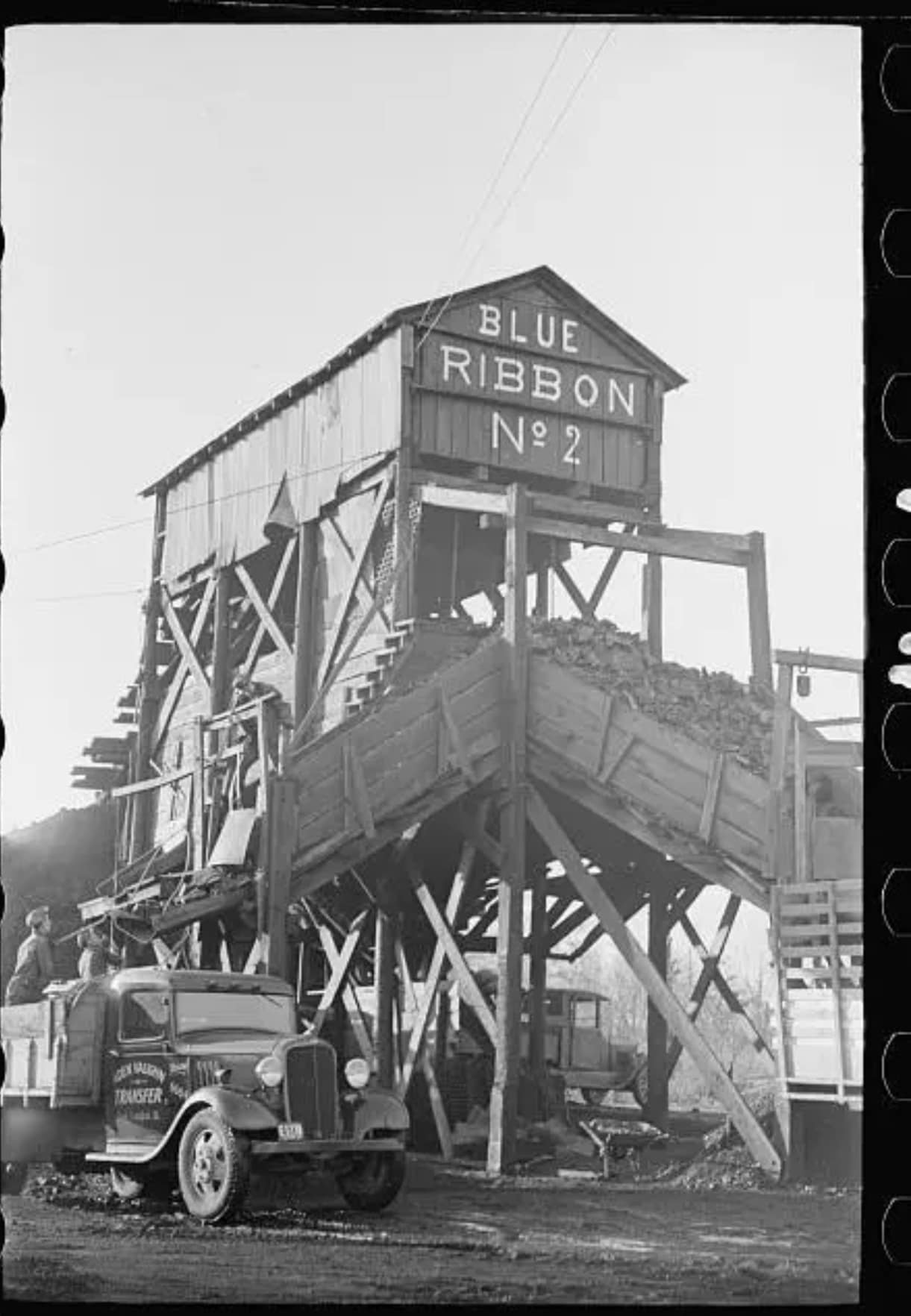
Williamson C: Spillertown, IL: Blue Ribbon #2 Mine

(Satellite, I could not find the exact location of the tipple)

Roger Kujawa posted
Blue Ribbon No. 2 Mine, Williamson County, Illinois, IL, Arthur Rothstein, FSA, 4
Mark Miller: Roger if I am reading my mine map right that mine is basically across the road from where I live. The mine opened 1936 closed in 1946 and it shows it as a slope mining the Springfield vein.

Roger Kujawa posted three photos with the comment: "Blue Ribbon No. 2 Mine, Williamson County, Illinois, IL, Arthur Rothstein, FSA, 6."
1

2

3

Roger Kujawa posted
Williamson County Illinois 1939 Blue Ribbon No 2 Mine Coal Truck Loaders

Directory

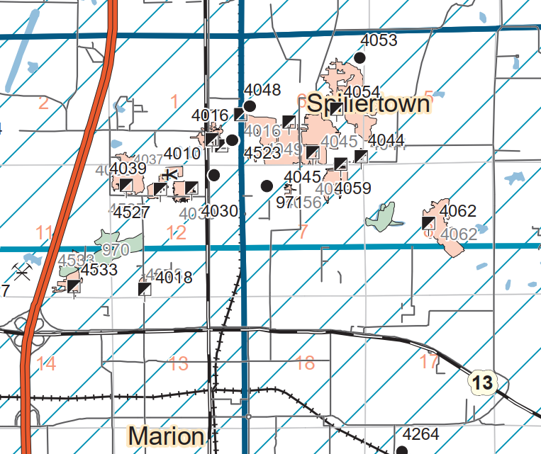
I spent too much time on this one because the maps include just the major roads and because the information is not consistent among the sources of information.

This Springfield seam map has 4049 a little southwest of the "S" in Spillertown.
Map-Springfield

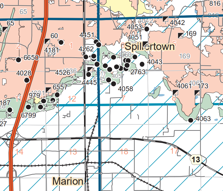
I found the topo map because they have some of the local roads. But it does not have 4049. Then it occurred to me that this might be the Herrin seam instead of the Springfield seam. So...
https://wikiimage.isgs.illinois.edu/ilmines/webfiles/topo-mines/johnston-city.pdf

...I got the comparable Herrin seam map. I was surprised that this map and the above map have so few mine indexes in common. In fact, 4451 is the only index I found on both. But this shows the topo map is of the Herrin seam because of the strip mines. I think the blue lines are township lines and they correspond to the red lines on the topo map.
Map-Herrin

I could not find the tipple on a historical aerial. From the photos, it is obvious that the tipple is not rail served so it would have a small footprint on the aerial. I assume that the C&EI had a coal loading facility that served this and the many other mines in the area.
1938 Aerial Photo from ILAP

In fact, some nearby railroads might have provided competitive coal loading facilities.
1941 Franklin Quad @ 62,500

This was the content of a duplicate post


(Satellite, this was probably their waste pond.)

Roger Kujawa posted
Loading a truck at Blue Ribbon No. 2 Mine,Williamson County,Illinois,IL,FSA,1
Mark Ballard: North of Marion
Mine pond still there
Raymond Barr: Located where?

Dennis DeBruler commented on Raymond's comment
Given Mark's comment about a pond, I think this is the pond: https://maps.app.goo.gl/FHX7hCRprVKzxa3d7 Index 4049 was the Blue Ribbon #2 Mine. It operated 1934-46. https://wikiimage.isgs.illinois.edu/ilmines/webfiles/topo-mines/johnston-city.pdf

Directory
It operated in the Springfield seam.

Map

For a while I was confused because I could not find a rail spur that served the mine. Then I had my "duh" moment: there was no rail service. That is why they are loading trucks. There must have been a coal cleaning and loading facility somewhere next to the C&EI that served the many small mines in this area.
1938 Aerial Photo from ILHAP