Saturday, July 29, 2023

Antonito, CO: Cumbres & Toltec Scenic/DRG&W Depot, Water Tower and Round Fields

Original Depot: (Satellite)
Tourist Depot: (Satellite, 1,812 photos)
Engine Servicing: (Satellite)
Restoration: (Satellite)
Water Tower: (Satellite)

According to a comment, the Town of Antonito bought this depot in 2006 from the Union Pacific.
Street View, Sep 2012

Friends of the Cumbres & Toltec Scenic Railroad, Inc. posted
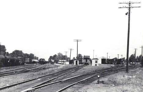
The Santa Fe Branch or Chili Line branched off from Antonito, Colorado, and headed south to Santa Fe, New Mexico, via Tres Piedras and Espanola. The line was abandoned in September 1941.
 The Antonito Depot sat between the tracks leading south to Santa Fe and south to Chama. In this photo, the straight tracks are the Santa Fe Branch on the left. The line curving to the west is the San Juan Extension heading to Chama and Durango.
 This undated photo was taken by John W. Barriger III and is part of the Friends’ Historic Photo Collections. FCTS RD016-061 
Simon J Court: Ah, so the existing industrial branch is on the path of the Chili Line.
Robert Wanner: Noticed that the switch is thrown for a standard gauge move onto the narrow gauge line, but the standard gauge didn't extend very far. Just something of interest. In steam days this was most likely to the servicing facilities, water tower, etc. for both gauges. Just saying.
John Franklin: I have often wondered what would have happened if the Chili line wasn't abandoned when it was. Rio Grande could have made extra millions of dollars with all the freight they could have hauled for the atomic bomb project. It was a neat line and a good one to model.
Charles Wells: As the Manhattan project was already underway by the time we entered the war after pearl I have always been very suspicious as to why the line to Santa fe was so hastily abandoned, when it obviously could have been a very useful military supply line. That is exactly why the government kept the Rgs.
Friends of the Cumbres & Toltec Scenic Railroad, Inc.: The line between Antonito and Alamosa was dual gauge for many years.
Terry Boardman: And it was quite common for trains between Alamosa and Antonio to convey both standard and 3 foot gauges vehicles. These could be worked by locomotives of either gauge. There were special “idler” freight cars with additional couplings and air brake connections to facilitate these mixed gauge trains.

Paul Biwer, Sep 2022

The Denver, Rio Grande & Western structures are gone. C&T has built their own facilities out-of-frame to the lower left.
EarthExplorer: Jul 17, 1966 @ 29,200; AR1VBLS00010130

The thing that struck me when I first looked at the old photo was that there was no grain elevator in a small town railroad scene. Then I noticed that this was in Colorado. There are no big wheat or corn fields in the mountains of Colorado. But there are now green fields. Obviously, they are using pivot irrigation.
Satellite

In fact, they are about everywhere where the land is flat.
Satellite

I'm guessing that they are growing alfalfa.
Street View, Sep 2012


Friday, July 28, 2023

Bay City, MI: NYC/Michigan Central Wenona Railyard, Roundhouses, Coaling Tower and Depot

Wenona Railyard: (Satellite)
Wenona Roundhouse: (Satellite, note the curved foundation remnant on the north side.)
Downtown Roundhouse: (Satellite, note the landscar of the filled in stall pits.)
Depot: (Satellite, north of First Street and between Monroe & Van Buren Streets.)

Michigan Railroad History Conference posted
A view of the New York Central roundhouse in the Wenona Yard at Bay City. This is in the twilight of steam on the former Michigan Central in June 1953. This scene was recorded by Fred Steck with Mikado #1350 and four other locomotives present. A potion of this roundhouse still stands today and is used by a metal fabricator.
Daniel C Carroll Jr. shared

Dennis DeBruler commented on Daniel's share
You can also see the remnants of some stalls for a roundhouse that was in the town.
 https://www.google.com/maps/@43.609119,-83.8940921,177m/data=!3m1!1e3?hl=en&entry=ttu
1916 Bay City Quad @ 62,500

When capturing the stall remnants, I included the MoW equipment. It is good to see evidence of a shortline doing trackwork.
Satellite

Raymond Storey posted
Jim Kelling shared
Bay City, Michigan (Michigan Central)

Dennis DeBruler commented on Jim's share [AR1VDI000110153]
The roads have changed a lot since this 1954 aerial photo was taken. That is why I included the Johnson and 3rd Street Bridges to help correlate the aerial with today's satellite images. The depot was north of First Street and between Monroe & Van Buren Streets.
Jim Kelling: Dennis DeBruler thanks I had trouble finding it on Google earth

Dennis DeBruler commented on Jim's share
The building on the left side of the postcard is extant, https://maps.app.goo.gl/De2ZJNYbsjbuo72P8.
Jim Kelling: Dennis DeBruler probably used for freight or Railway Express Agency

Raymond Storey posted seven photos with the comment: "BAY CITY MI ...PHOTO CREDIT DAVE PRUDEN AND KATHY WOODS."
1

2

3

4

5
Raymond Storey posted
Tim Shanahan shared
BAY CITY MI ...PHOTO CREDIT DAVE PRUDEN AND KATHY WOODS

6

7

Raymond Storey posted four photos with the comment: "BAY CITY MI .......PHOTO CREDIT CATHY WOODS."
1

2

3

4

Wells (Escanaba), MI: Escanaba & Lake Superior (ELS) Roundhouse

(Satellite)

See "CN Closing" for more information concerning the the ore docks.

This railroad has the same name today that it had in the early 1900s. That is so rare that the only other non-tourist railroad that I can think of that still has its original name is the Union Pacific.

Michigan Railroad History Conference posted
Escanaba & Lake Superior #102 and crew pose at the Wells roundhouse. Photo is undated and photographer is unknown. Locomotive #102 is a Baldwin S8 built in 1952.
Daniel C Carroll Jr. shared

Greg Bunce commented on the above post
What it looks like now.

Terry B. Carlson commented on Daniel's share
Still there and still in use. It's a "switched" RH, no TT.
Google Earth Imagery Date: 5-24-2023
Location: 45.7765299,-87.065236

The ELS started out as a logging road that fed a sawmill in Wells, MI. Between 1900 and 1937, it hauled Milwaukee Road ore trains to an ore dock. But in 1937, Milwaukee Road started sharing C&NW's ore dock. When the ELS picked up trackage from the Milwaukee Road bankruptcy in the late 1970s, it more than tripled its trackage. And it continued to grow as more trackage was shed by Class I railroads. [American-Rails]

Edward Gross, Jan 2018

"The E&LS has a major business line storing and refurbishing freight cars. They use a former C&NW car shop at Escanaba for car repairs and refurbs." And much of their current trackage is now used to store cars. [MichiganRailroads]


It has accumulated a lot of vintage locomotives. RailroadFan has a list.

1932 Gladstone SE Quad @ 31,680

Aug 2026:
John Fry Images posted
Hitting the road again for another loop around the US and knocking the dust off the camera. It's great to have images to share here again.
First stop was Escanaba, MI and I wanted to check in on what was, for many years, the storage location of a long line of old, rare locomotives. For whatever reason The Escanaba and Lake Superior RR began scrapping those locomotives recently and I wanted to see if anything was left.  Michigan's upper peninsula is very rural with only a little over 300,000 people inhabiting the over 36,000 square miles of territory. In the 19th century the "UP" bustled with mining and lumber industry driving railroad expansion. Today only scraps are left and most of the railroad right of way's are now snowmobile trails to help bolster the current leading economic draw of the UP- tourism. 
The ELS is still trying to hang on with whatever business it can eek out, but the visible deferred maintenance and the sale/scrapping of assets is often writing on the wall.
The line of old locomotives were moved to the shop tracks and cut up, having now been replaced by boxcars- hopefully here to generate revenue through either storage or contracted repair. The maintenance shop has a gaping hole in the roof, and one of the railroad's newest locomotives languishes in the weeds.
Joe Anderson Jr.: Old Roundhouse maintenance shop! They relocated because of the roof issues.
Edwin O'Connor: Drove along the Grand Elk yesterday from Trout Lake to Munising. Looks to be in reasonable shape--and I also noticed new ties placed along the tracks. Very positive sign for that line in the U.P.!
John Fry Images shared


Thursday, July 27, 2023

Rochester, NY: Kodak Plant

Headquarters: (Satellite)
Kodak Center: (Satellite, 975 photos) "Sprawling complex featuring live music, comedy & theater productions on multiple stages."

If you are here because of the B&O railyards, then to go "B&O Brooks Avenue and Lincoln Park Railyards and Roundhouse."

Mark Graczyk posted
Kodak Park at entrance to Eastman Kodak Co., Rochester, N.Y., circa 1920s.
Shawn Baxter: I'm still there working on 35mm film machines.

The trees are a lot bigger.
Street View, Aug 2024

I noticed the smokestack in the background of the above photo, so I checked it out.
Street View, Nov 202

some of the buildings have been converted into theaters for the performing arts and event spaces.
Street View, Aug 2022

This photo was moved to here.

Wednesday, July 26, 2023

Belews Creek, NC: 1974 2.2gw Duke Power

(Satellite)

Duke also built a dam to create Belews Lake as the cooling pond for this plant.

Duke Energy Flickr, License: Creative Commons Attribution-NonCommercial-NoDerivativeWorks (CC BY-NC-ND)
Belews Creek Steam Station, a two-unit coal-fired generating facility located on Belews Lake in Stokes County, North Carolina, began commercial operation in 1974. It is Duke Energy’s largest coal-burning power plant in the Carolinas with a capacity of 2,240 megawatts and consistently ranks among the most efficient coal facilities in the United States. Both of the Belews Creek generating units have been equipped with selective catalytic reduction (SCR) devices to reduce nitrogen oxide emissions by approximately 80 percent. Duke Energy has also installed flue gas desulfurization equipment – commonly known as scrubbers – on both units. This equipment will reduce the station’s sulfur dioxide emissions by approximately 95 percent.
More info here: www.duke-energy.com/power-plants/coal-fired/belews-creek.asp
[Actually, this plant's information is here. In 2020-21, natural gas was added to the plant. It can burn a combination of natural gas and coal up to 50% gas. "For every pound of coal displaced with natural gas, sulfur dioxide is reduced by an estimated 99%, and carbon dioxide emissions are reduced by about 40% per megawatt-hour."]

"Units and In-Service Dates: 1,080 MW (1974), 1,080 MW (1975)" In 2009, the EPA rated the ash pond as High Hazard Potential. [gem]

This source rates the plant at 2.5gw.

Tony Josephs posted seven photos with the comment: "Belews  Creek  NC coal fired steam station."
William Mccue: Super critical … all us Furmanite guys hated that place . Them leaks ain’t no joke !
Scott Leonard: William Mccue I hear ya! Plugging HPFH tube leaks with explosives was another crazy job. Lucky up at Chalk Point classified Team Leak and Senior Engineering/ Perfex Services/ TEI as 2 of the crazy groups of guys. Of course I was there.
[I know that supercritical means that the water in the boiler tubes is under very high pressure. (For example, the first supercritical unit in the US operated at 4,500psi. [AEP in Philo, OH]) But I have no idea how you plug a pipe leak with explosives.]
1

2

3

4

5

6

7

Another reminder that trees grow like weeds on the east coast and that it is hard to get good street views. At least this view shows that the plant was still operational in 2023.
Street View, Feb 2023

According to a USGS map, BX owns the spur that joins the RW railroad. According to a 1971 topo map, RW operates a former N&W route. The BX has a couple of cute blue switchers.
Satellite

Duke has the same complaint about the "100 dirtiest power plants" that I have: it should rate dirt/mwh, not just dirt. [TheStockesNews] Of course the big power plants are going to have more emissions than dinky, and dirty, old power plants.

According NASA observations, the selective catalytic reduction (SCR) equipment did a good job of reducing its nitrogen oxide emissions. (The y-axis is latitude, and the x-axis is longitude.)
NASA
 
The SCR was added in 2005, and the “flue gas desulfurization system” was added in 2008. [myfox8]

I wonder when the two old smokestacks were removed.
Sreenshot

All four smokestacks were standing in Feb 2019, but they were gone by Sep 2020.
Global Earth, Feb 2019

"Belews Creek Steam Station has 104 groundwater monitoring wells, 54 of which have been polluted above federal advisory levels based on samples collected between January 06, 2011 and April 15, 2019. Groundwater at this site contains unsafe levels of cobalt, lithium, boron, manganese, arsenic, radium, beryllium, molybdenum, mercury, selenium, chromium and sulfate....From 1974 to 1986, the station discharged wastewater with high selenium concentrations (150-200 ug/L) to Belews Lake. As a result, 19 species of fish were eliminated from the lake." [AshTracker]
In 2019, Duke agreed to dispose its ash in a lined onsite landfill. [DepartmentEnvironmentalQuality]
Moving the ash to a new lined landfill will eliminate the unlined waste ponds. [MtairyNews]

Note the dam that they built near the top of this satellite map to create their ash pond. [epa, p15] The pond looks like it still contains a rich variety of crud.
Google Earth, May 2021

This article caused me to look for an emergency spillway for the earth dam. At first, I was shocked that I could not find one. I would rather see some toxic water go over a spillway than have a breach and send "12.5 million tons of coal ash" down the Dan River. I guess the saving grace is that the watershed for this dam is just the pond itself. So the contribution of water from a rain should be relatively small.
Satellite

At least the deluge of water would dump directly into Dan River instead of into the Belews Lake. Thus the deluge wouldn't wipe out the lake's dam.
1971 Belews Lake Quad @ 24,000

appvoices
"Importantly, the sites Duke has not committed to excavating are the largest in the state, including the 12.5 million tons of ash at Belews Creek, the 11.5 million tons at G.G. Allen, and the 27 million tons of coal ash stored at the Buck and Marshall plants. That amounts to more than 70 million tons — the bulk of Duke’s coal ash — still sitting in leaking, unlined ponds seeping and discharging into our waterways."
[But wait, they agreed to remove the pond in Jan 2020. [TheStokesNews] One can stop air pollution by shutting down the power plant. But shutting down the power plant does not stop groundwater pollution nor the hazard of a dam breach.]

By 2017, Duke had accumulated an impressive criminal record concerning lying and procrastination with respect to its ash pond hazards. [WaterKeeper]