Monday, January 29, 2024

Batavia, NY: DL&W/NYC Roundhouse and Bridges

Bridges: (Satellite, only the northern one is left.)
Roundhouse: (Satellite)

DL&W = Depew, Lancaster & Western Railroad

The blue building is the roundhouse.
Street View, Aug 2019

Street View, Jul 2022

Memories of Batavia,Ny posted
The one on the right, looks like an erector set bridge, if you zoom in, you can see people on the tracks. The Greg B collection
Monica Irwin: Where?
Michael Dow: Monica Irwin Batavia over the tondawa looking.from route 98. Only one of the bridges
is still there
Mantonia Medina shared

Dennis DeBruler answered Monica's question
 https://www.google.com/maps/@42.9949026,-78.1913541,155m/data=!3m1!1e3?entry=ttu
As a bonus, I found a roundhouse.

1950 Batavia South Quad @ 24,000

The roundhouse has just two stalls so it uses a turnout instead of a turntable.
Satellite

ChrisMarie Nielsen-Hess posted
Old city map of my hometown on the left showing the engine house and on the right as it sits today.

Tim Ingerson posted
Seen this in Gvt's Batavia yard, question to anyone. Was this building a former round house if so if there's any pictures I'd love to see.
Scot Lawrence: Yes, it was a roundhouse, with a turntable, and during the steam era it was directly alongside the NYC 4-track mainline right through the middle of Batavia. NYC re-routed the mainline out of the center of town in the 1950's, which is the line currently used by CSX. DLWR moved in to the roundhouse in 2008, and they held a public open house April 17, 2009! 🙂 my photos from 4/17/2009:

Chris Ketch commented on Tim's post
Here's one I've found.

Chris Ketch commented on Tim's post

Sunday, January 28, 2024

Omaha, NE: UP 1891 Harriman Dispatching Center and Headquarters

Dispatching: (Satellite)
Headquarters: (3D Satellite)

Street View, Aug 2022

I'm saving a 3D view of the headquarters while there is not a building on the south side.
3D Satellite

Street View, Aug 2011

Untold History of Southeast Nebraska added
Harriman Dispatching Center, Omaha, NE - "The Harriman Dispatching Center is Union Pacific’s main control center, operating most of the fleet and track of the nation’s largest railroad company, Union Pacific. Called the “Bunker” by some, this building, two football fields long, is where the movement of hundreds of trains on 32,000 miles of track is controlled and monitored. It was built in a former freight depot building in 1989, and employs over 750 people, around 60 of whom are dispatchers who work in the “bunker” itself, like slower-motion air traffic controllers watching a series of 172 screens that show every switch and signal track on UP’s lines. The corporate headquarters for Union Pacific is located nearby in downtown Omaha." - Center for Land Use Interpretation - Creative Commons
Gene Adams: It is actually a bunker. The dispatch center is in a concrete, tornado proof bunker inside the building. Our tour person side it could withstand a direct hit of a tornado plus it has backup systems to run the center for days.
Douglas Potthoff: Gene Adams They receive electrical from 2 utilities in 2 states, plus their own backup.

clui, License: Creative Commons Attribution-NonCommercial-ShareAlike (CC BY-NC-SA)
The text on this webpage differs slightly from their Facebook post above: "the movement of over 850 trains and nearly 23,000 miles of track."

GatewayNMRA
[This has a date of 2000 and an update saying that it has been remodelled since the photo was taken. I wonderedif it was now different when I saw CRT monitors.]

America's Power Flickr
The Harriman Dispatching Center looks modern on the inside, but it's actually an old freight house built in 1891. 
[Their photos of the center starts here. The highest mileage figure I saw in the comments was 36,000. And that comment called the UP the largest railroad in the world.]

Union Pacific Railroad posted
Our Harriman Dispatching Center (HDC) in Omaha, Nebraska, is one of the most technologically advanced dispatching facilities in the U.S. Employees at the HDC function as rail traffic control, operating 24/7 to keep trains on the move. Systemwide, 469 UP train dispatchers work eight-hour shifts to keep 81 desks running.
The center lives inside a historic brick building constructed in 1891 as a freight house. A reinforced concrete bunker surrounds the dispatchers and hundreds of large and small computer screens. The building was renovated in 2007 to add a sound-absorbing ceiling, state-of-the-art air handling equipment featuring antibacterial ultraviolet lights and heat-reclamation equipment, so no supplemental heating is required. 
Fibre-optics, telephone lines and radio are used to align switches and set signals. Every single train on our 32,000-mile system can be tracked and dispatched from this building. Two massive generators and two power companies keep the building up and running through power outages, ensuring Union Pacific never stops delivering the goods Americans use every day.
up_union, different exposure

up_inside
"35,252 track miles made up of main track, sidings and industrial leads. It’s not just the distance you would travel to circle the Earth almost twice, it’s also the number of main line miles cut over during Union Pacific’s Computer-Aided Dispatching system (CADX) efforts – now complete."
CADX Cutover by the Numbers
35,252 track miles
Nearly 70,000 assets made up of switches, signals, milepost markers and signs
1,023 subdivisions and industrial leads
73 train dispatcher desks across nine locations
472 days, first desk to last desk cutover

Back when the freight house was a freight house.
1956 Omaha North and South Quads @ 24,000


Lemoyne, PA: Pennsy Lemo (J) Tower: Pennsy vs. Pennsy

Original: (Satellite, I see there is still an overpass from the route along the river. A route along the river, Northern Central, used to cross a route that went over the river, Cumberland Valley. The tower was in the southwest quadrant of the crossing.)
Current: (3D Satellite)

(I used to drop a pin on a tower's historical location, but I quit doing that because Google Maps now moves the location of the pin. And the error depends on the zoom factor. See the aerial photo below for details.)

See MichaelFroio for a history of the train traffic through, and later around, this junction.

The tower was moved in 1983. [prrths]

It has been preserved in the Strasburg Railroad Museum.
Street View, Aug 2014

This map taught me that the crossing was just west of the river.
penndot

Darren Reynolds posted seven images with the comment: "PRRs "Lemo" (J) tower
Lemoyne, Pennsylvania."
David Foubert: Is that diamond and interlocking still there ?
Darren Reynolds: David Foubert No the only thing there is the CV branch that goes to intermodal yard at Greencastle,Pa. But the tower was saved and moved to Strasburg railroad.
1
"Lemo" tower was built and put in service
3/13/1907 and it originally faced the Cumberland Valley branch..
Photo By: Paul Geiger May 1977
Darrren Reynolds posted
"Lemo" tower was built March 13,1907 With a machanical interlocking machine on December 31,1956 The Pneumatic machine was put in service.
The tower Now Resides at world famous Strasbourg railroad. Photo by: Paul Geiger May 1977

2
Standing on a Cumberland valley branch a
Green "Lemo" tower June.1975
Photo By: Rob Mandeville

3
Model board and interlocking machine.. the model board on top is for. "Camp" interlocking
South of "Lemo" tower 1984
Photo By Robert Rinker

4
The desk and bay window at "Lemo" tower
Mar.11,1978
Photo By: Tim Garner

5
A Conrail train on the Cumberland valley branch is crossing the northern Central branch
At "Lemo" tower. May 1979
Photo By: Geoffrey Hubbs

6
This is where the catenary crosses one another.
the only one on the Pennsylvania railroad system. At "Lemo" tower. Sorry no date and photographer and this is a mirror image photograph.

7
Interlocking diagram of "Lemo" tower
Drawn by: Ed Spodobalski

EarthExplorer: Oct 19, 1959 @ 60,000; ARB593500200174

The above aerial indicates that the black square in the southwest (or south) quadrant of the crossing on this topo map is the location of the tower. (Topo maps normally don't record the location of railroad towers.)
1963 Lemoyne Quad @ 24,000

Diagram via RedOverYellow

Photo via jbritton, one of many photos on that webpage of the area

I chose the above photo because I believe the steel girders in the foreground are part of this overpass.
Street View, Oct 2023

This photo shows the catenaries crossing each other. Since both routes were electrified, this grade crossing had crossing catinaries. I read somewhere that this was the only crossing catinaries on the Pennsy system.


Saturday, January 27, 2024

Cly, PA: Lost/Pennsy Tower and Depot

Tower: (Satellite)
Depot: (Satellite)

The depot was west of the tower.
ConrailPhotos
Overall view of CLY Interlocking Tower and adjacent Station. CLY controlled the junction of the PRR's Northern Central Branch to Baltimore along with the PRR's Atglen & Susquehanna line to Columbia. The 2 tracks closest to the tower are the Northern Central Branch. This tower used an Armstrong Lever Machine. It was taken out of service sometime in 1985 or 1986 and demolished in the late 1980's.
Photographer: Ivan Frantz Jr.
Photo Date: 06/04/82

I found the satellite locations of the tower and station using the following valuation diagram and the 1961 aerial photo.
Diagram via jbritton, this webpage has several photos of the tower including an interior shot

Dennis DeBruler commented on the following post
The tower was at the end of Railroad Ave. in this 1961 photo, 
https://maps.app.goo.gl/59CqmMJYDPn6b8cv8 [AR1VAEK00010091]
It is interesting that almost all traces of wye have disappeared.

Darren Reynolds posted nine images with the comment:
PRRs  "Cly" tower, Pennsylvania
Near Harrisburg,Pa.
1
"Cly" tower built 4/9/06
Photo By: Glen Kirby

2
Looking East "Cly" tower
Photo By: Unknown

3
Inside of "Cly" tower the interlocking machine was saved. It's in a box car at the Pennsylvania
Railroad museum in Strasburg Pennsylvania..
Photo By: Glen Kirby

4
Model board and interlocking machine at
"Cly" tower
Photo By: Glen Kirby

5
Inside of "Cly" Tower with a visitor
Photo By: Glen Kirby

6
Looking East ”Cly" tower
Photo By: Glen Kirby

7
Looking West from inside the towers bay window "Cly" tower
Photo By: Glen Kirby

8
A colored picture of "Cly" Tower
Photo By: Paul Geiger

9
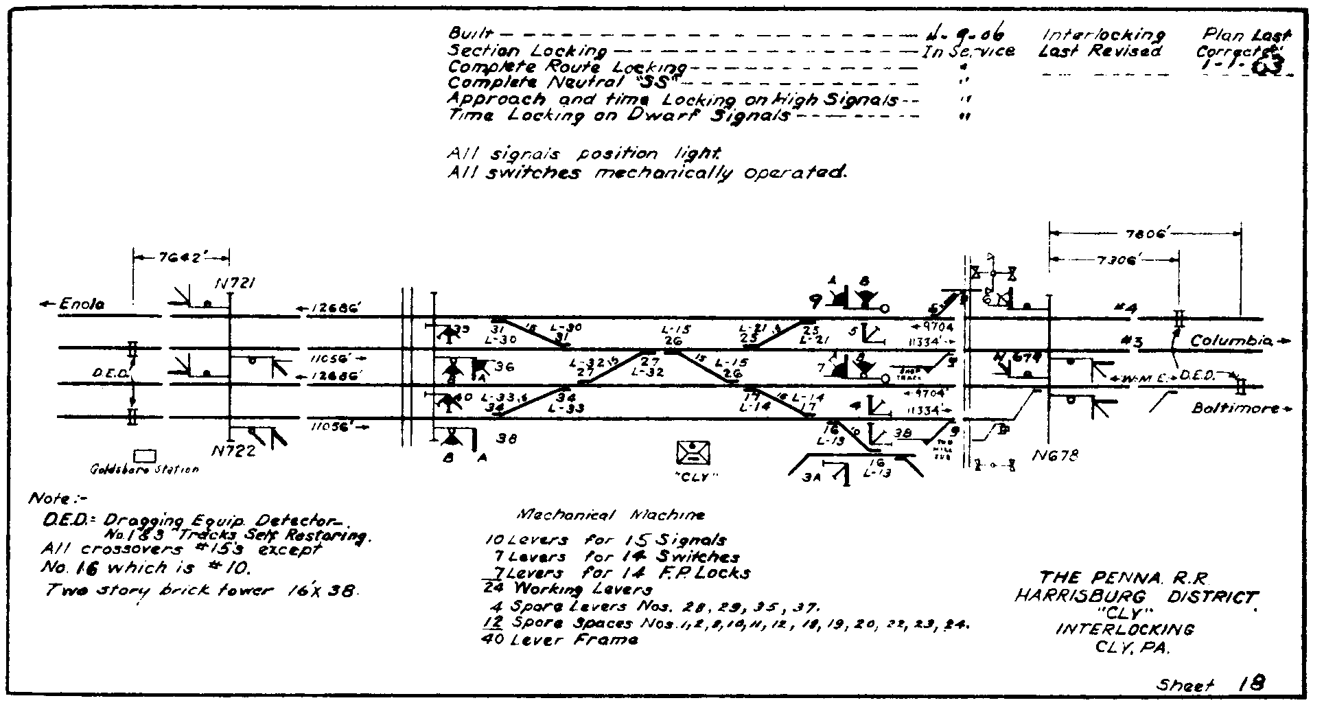
Interlocking and track diagram "Cly" tower

I love this photo because it shows some of the signalling pipelines and the fact that they can bend around curves.
ConrailPhotos_from_tower
Photographer: Ivan Frantz Jr.
Photo Date: 06/25/82
[Another photo]

Diagram via RedOverYellow [It is good to know that someone has resurrected the boradway.pennsyrr.com diagram collection.]

MichaelFroio
'"Leaving the greater Harrisburg / Enola area from the west bank of the Susquehanna, the PRR’s York Haven Line drops down river toward Columbia, PA. This line was a key component of PRR president Alexander J. Cassatt’s plan to build a low-grade freight bypass diverting traffic off the mainline from the Philadelphia area. Existing lines and new construction in the early 1900’s provided access to Baltimore by way of both the Northern Central via York and the Columbia and Port Deposit Branch via mainline connection at Perryville, Philadelphia via the new Atglen & Susquehanna and Lancaster via the original Philadelphia & Columbia. Running a distance of 15 miles east from Enola Yard along the former Northern Central alignment, this “branch” was actually one of the busiest electrified freight arteries in the east. Alongside the Susquehanna River in the town of Cly, the railroad maintained an interlocking here connecting the York Haven Line to the Northern Central. These lines would run parallel to Wago Junco where the NC drops southwest toward the city of York."
[I included the grade crossing and bridge in the upper-left corner of the above 1961 aerial photo.]

The diagram in Image 9 above confused me for quite a while because I could not find the bridge. Then this topo map helped me to finally realize that the scale for that diagram is much larger than for a typical track diagram: CLYYORK HAVEN, WAGO JCT. and the bridge.
1964 York Haven Quad @ 24,000

This map helped me understand the "Northern Central line to York."
penndot