Depot: (Satellite)
I found the satellite locations of the tower and station using the following valuation diagram and the 1961 aerial photo.
The depot was west of the tower.
 |
| ConrailPhotos Overall view of CLY Interlocking Tower and adjacent Station. CLY controlled the junction of the PRR's Northern Central Branch to Baltimore along with the PRR's Atglen & Susquehanna line to Columbia. The 2 tracks closest to the tower are the Northern Central Branch. This tower used an Armstrong Lever Machine. It was taken out of service sometime in 1985 or 1986 and demolished in the late 1980's. Photographer: Ivan Frantz Jr. Photo Date: 06/04/82 |
I found the satellite locations of the tower and station using the following valuation diagram and the 1961 aerial photo.
 |
| Diagram via jbritton, this webpage has several photos of the tower including an interior shot |
 |
| Dennis DeBruler commented on the following post The tower was at the end of Railroad Ave. in this 1961 photo, https://maps.app.goo.gl/59CqmMJYDPn6b8cv8 [AR1VAEK00010091] It is interesting that almost all traces of wye have disappeared. |
Darren Reynolds posted nine images with the comment:
PRRs "Cly" tower, PennsylvaniaNear Harrisburg,Pa.
 |
| 1 "Cly" tower built 4/9/06 Photo By: Glen Kirby |
 |
| 2 Looking East "Cly" tower Photo By: Unknown |
 |
| 3 Inside of "Cly" tower the interlocking machine was saved. It's in a box car at the Pennsylvania Railroad museum in Strasburg Pennsylvania.. Photo By: Glen Kirby |
 |
| 4 Model board and interlocking machine at "Cly" tower Photo By: Glen Kirby |
 |
| 5 Inside of "Cly" Tower with a visitor Photo By: Glen Kirby |
 |
| 6 Looking East ”Cly" tower Photo By: Glen Kirby |
 |
| 7 Looking West from inside the towers bay window "Cly" tower Photo By: Glen Kirby |
 |
| 8 A colored picture of "Cly" Tower Photo By: Paul Geiger |
 |
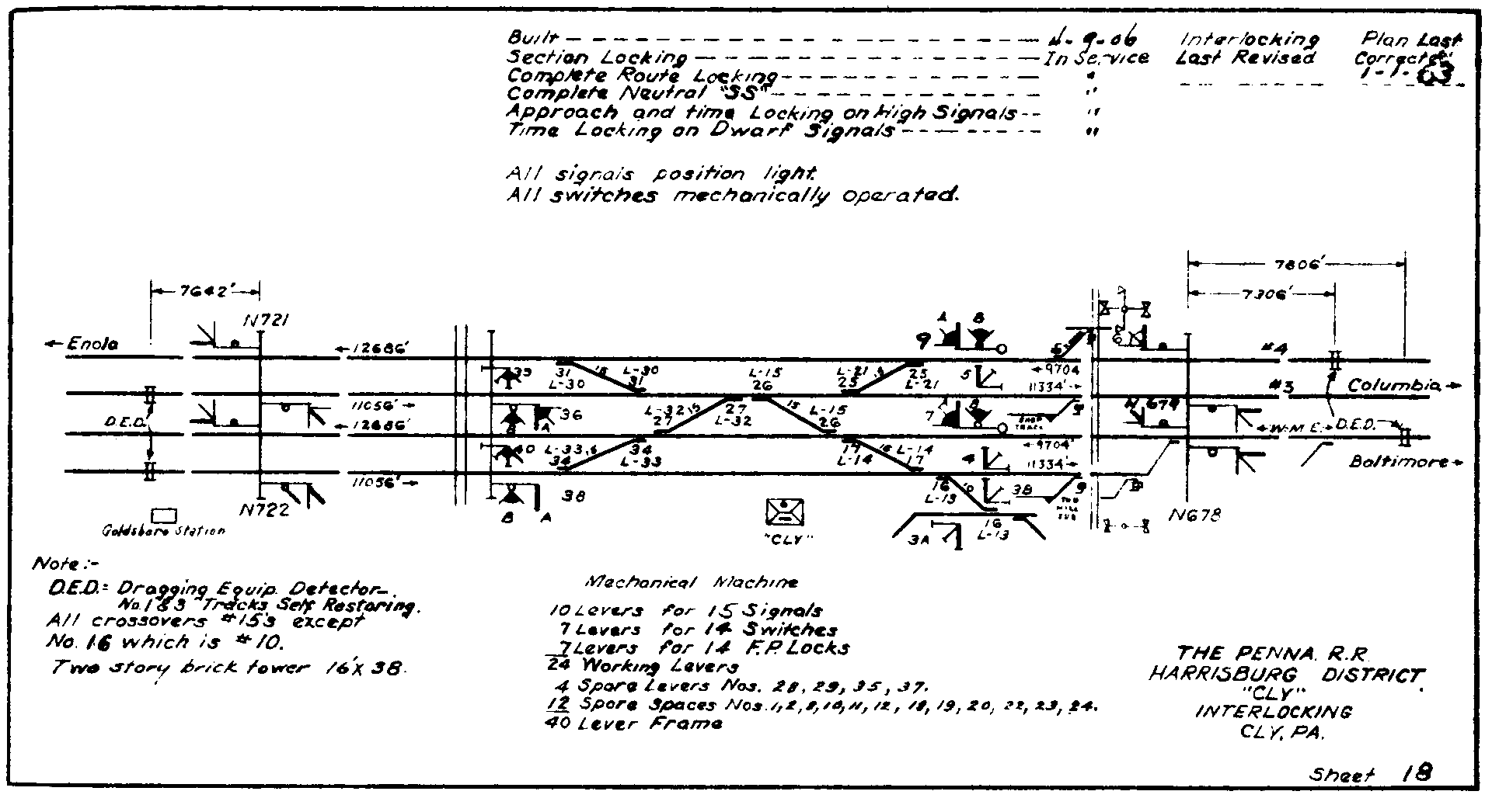
9 Interlocking and track diagram "Cly" tower ALL images from North American interlocking States A to Z and Canada. |
I love this photo because it shows some of the signalling pipelines and the fact that they can bend around curves.
 |
| ConrailPhotos_from_tower Photographer: Ivan Frantz Jr. Photo Date: 06/25/82 [Another photo] |
 |
| Diagram via RedOverYellow [It is good to know that someone has resurrected the boradway.pennsyrr.com diagram collection.] |
 |
| MichaelFroio '"Leaving the greater Harrisburg / Enola area from the west bank of the Susquehanna, the PRR’s York Haven Line drops down river toward Columbia, PA. This line was a key component of PRR president Alexander J. Cassatt’s plan to build a low-grade freight bypass diverting traffic off the mainline from the Philadelphia area. Existing lines and new construction in the early 1900’s provided access to Baltimore by way of both the Northern Central via York and the Columbia and Port Deposit Branch via mainline connection at Perryville, Philadelphia via the new Atglen & Susquehanna and Lancaster via the original Philadelphia & Columbia. Running a distance of 15 miles east from Enola Yard along the former Northern Central alignment, this “branch” was actually one of the busiest electrified freight arteries in the east. Alongside the Susquehanna River in the town of Cly, the railroad maintained an interlocking here connecting the York Haven Line to the Northern Central. These lines would run parallel to Wago Junco where the NC drops southwest toward the city of York." [I included the grade crossing and bridge in the upper-left corner of the above 1961 aerial photo.] |
The diagram in Image 9 above confused me for quite a while because I could not find the bridge. Then this topo map helped me to finally realize that the scale for that diagram is much larger than for a typical track diagram: CLY, YORK HAVEN, WAGO JCT. and the bridge.
 |
| 1964 York Haven Quad @ 24,000 |
This map helped me understand the "Northern Central line to York."
 |
| penndot |
No comments:
Post a Comment