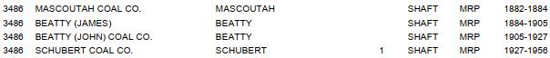
Kolb: (
Satellite)
Home: (
Satellite, note that Mine Road north of
the tree clump is where the L&N spur ran)
Schubert: (
Satellite, southwest corner of Main and Railway Streets)
While looking for remnants of the mines on the satellite map, I noticed that Mascoutah is the home of the
$300m aiport that serves 4 airplaines a WEEK.
All of these mines were room and pillar.
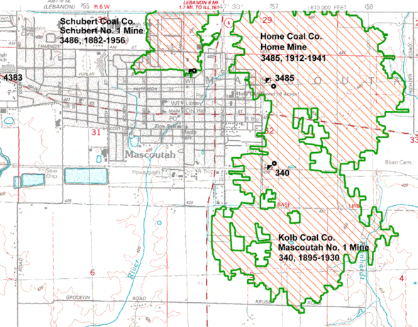
Kolb Mine
The above postcard is a colorization of the photo that appears on page 61 of
eBook.
The shaft was 6'x12'. Between 1895 and 1930 it produced 3,096,758 tons. The Herrin seam was 160' deep and the thickness varied between 6' and 8' with an average of 7'. [
ISGS-Kolb]
Home Mine (Opened in 1912 as Kolb Coal Co. Mascoutah #2)
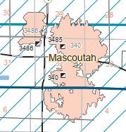
The ISGS could not distinguish the boundary between Kolb and Home Mines, that is why there is just a 340 polyogn of 978 acres in the first map below.
The shaft was 7'x16'. Between 1912-1934 it produced 2,527,015. Most of that production was before 1934 while it was owned by the Kolb Coal Co. The Herrin seam was between 160-185 feet deep and the thickness varied between 6.5' and 9' with an average of 7.67'. [
ISGS-Home]
Schubert Mine
The shaft was 5'x10' and 155 acres were mined. Between sometime probably in the 1870s and 1956 it produced 864,128 tons. The Herrin seam was between 157-165 feet deep and the thickness varied between 6.5' and 7.5' with an average of 7'. [
ISGS-Schubert]
Abandoned L&N Spurs
The Abandoned RR Map shows that the L&N ran along the south side of town where
the L&N Ave. is now. CSX tore up the west end of the L&N route before it sold it to the
Evansville Western Railway. I assume that CSX did this to avoid competition for freight traffic to St. Louis and western railroads. This route would have been an attractive bypass of Chicago congestion for freight traffic from the Southeast to the West.
The Kolb tipple was built along the L&N so it did not need a spur. In fact, it supplied coal for the L&N trains. [
eBook, page 62] It was abandoned for a decade by the time this historic aerial was taken. We can see the spur on the east side that ran north to the Home Mine with a yard to the north of the mine. There was a spur that curved up to Market Street and worked its way to the Schubert Mine. Note that the railroad ran on Market Street instead of Railway Street. There is also a spur in the middle that probably went to an industry in the early 1900s. Judging from the trees, this spur was abandoned by 1940.
A 1912 topo confirms my thesis about the industrial spur into the east side of town. The spur to the Home Mine would have been built in 1912, which is not soon enough to show up on this map.
 |
| 1912 New Athens Quadrangle @ 1:62,500 |
The next available topo map in terms of dates is 1954. It also doesn't show the spur to Home Mine because that mine had been abandoned for over a decade. But it does show the street running to Schubert in better detail because that mine ran for two more years.
 |
| 1954 Mascoutah Quadrangle @ 1:24,000 |
Unlike many town in Illinois, this town grew up around a coal mine (Schubert) instead of the railroad. It appears the freight house and depot were south of town along the railroad. Also, I think the water tower was in the lower-right corner of this excerpt.


No comments:
Post a Comment