West Mine: (
Satellite)
North Mine: (
Satellite)
East Mine: (
Satellite)
Was Oct 2013 before they isolated this B&O route across southern Illinois?
 |
Rails Around Southern Illinois posted
C&O #614 steams east past a crowd of onlookers at the depot in Breese, milepost 298, on April 25, 1981. CSX removed the siding in 2021 but the depot still stands. (Don Wirth)
Our books are published and enroute! 256 pages in hardcover, filled with 650+ all-color images from all over southern Illinois, 1950-95. You can reserve your autographed copy here: https://michaelckelly.net/?p=7466
Michael C Kelly shared
Breese, IL on the now-dead former B&O St Louis line. |
 |
1 of 7 photos posted by Dave Durham
Last weekend, I braved the frigid cold and explored more of Caseyville, Illinois, former B&O, and CSX. I even found a lit signal! CSX is still powering the signal cabinets in places. I guess the line is not 'abandoned'; it is just out of service. It's never coming back though. I found the cut diamond in Shattuc.
Michael R Valentine: Where is this? [There are a lot] |
%20Abandoned%20Rails%20_%20Last%20weekend,%20I%20braved%20the%20frigid%20cold%20and%20explored%20more%20.png) |
| Some of the comments on Dave's post |
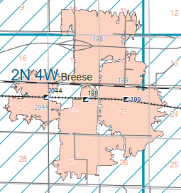
The directory on
the ISGS site has serious omissions. But from the article below we can conclude that
- 2044 was the 1881 West Mine that became the Consolidated Coal Co.
- 199 was the 1886 East Mine that became the Citizen's Coal Co.
- 198 was the 1904 Koch's Mine that became the North Mine of Breese Coal Co. In 1911, it produced 2700 to 3000 tons a day.
Unfortunately, the above map did not include any north/south roads so I could not find the mines on the aerial photo below. But this topo marks the location of the North and East mines.
 |
| 1906 Breese Quadrangle @ 1:62,500 |
The description of the settlement, including a couple of mills, around the old toll bridge reminded me that until the 1850s, settlements were dictated by water, both power and transportation. Starting in the 1850s, the economy transitioned from water to steam, both stationary steam engines and railroads. Specifically, the economy in Breese Township moved from along the river to where coal was found along the railroad.
Dennis DeBruler
posted two photos with the comment:
While studying the coal mines in Bresse, IL, I noticed the wye on the north side of the B&O tracks east of town in this 1938 aerial (yellow rectangle). The reason for posting this is not because of lines on the map. It is because there is still such an obvious "landscar" in a farmer's field.
https://www.google.com/maps/@38.606991,-89.5137359,306m/data=!3m1!1e3
 |
| 1 |
 |
| 2 |
Update:
 |
Roger Kujawa posted
C.U. Williams 1909 Lithograph Breese & Trenton Coal Mine At Breese, Illinois
Roger Kujawa shared |
 |
Ken Morrison commented on Roger's share
Could have been East or North; both shafts located right on the B&O, and both owned by Breese & Trenton at some point |
Another update:
Danielle Murray
posted three images with the comment: "North Mine (Koch's Mine) in Breese, IL. Photo from 1905, map from 1943, powder house as it stands today. If anyone has additional photos, please share!"
 |
| 1 |
 |
| 2 |
 |
| 3 |


%20Abandoned%20Rails%20_%20Last%20weekend,%20I%20braved%20the%20frigid%20cold%20and%20explored%20more%20.png)


No comments:
Post a Comment