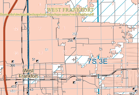
#11+#19: (
Satellite, the tipple was north of the tracks)
#18: (
Satellite, they cleaned it up pretty good)
 |
Roger Kujawa posted
1920's The Industrial Coal Co. Mine No. 18 in West Frankfort, Illinois Post card
Roger Kujawa posted |
 |
Roger Kujawa posted
Industrial Coal Company Mine 19,
West Frankfort, Illinois.
Roger Kujawa posted
Roger Kujawa posted a different colorization, or the monitor makes a difference.
West Frankfort, Illinois, Industrial Coal Co. Mine, Exterior, Kropp No. 890 N
Roger Kujawa posted
1950 border postcard Industrial Coal Co, Mine No. 19, West Frankfort, Illinois
Sally Holland: i think this is the one in pershing.
Dennis DeBruler: Sally Holland The state documents Industrial #19 as index 51, and it shows that 51 is in West Frankfort.
https://towns-and-nature.blogspot.com/2020/07/franklin-c-west-frankfort-il-industrial.html
Sally Holland: Dennis DeBruler pershing is a part of w f. it has a west frankfort mailing address. but i am still not sure of it's location. we had close to 10 mines then. i know #'s 9 and 2 but can't remember the names of the others. locals tended to call them by the area of town and not their #s. James D Rusher: Dennis DeBruler I remember this Mine was called Peabody 18 Mine. It was located on the North East side of West Frankfort about one mile North of the West end of the 4 mile lane near the old school house which is still standing. This road is also the back road from West Frankfort to Benton, Illinois. Dennis DeBruler: James D Rusher Thanks. Peabody #18 would make it Index 256. But the state map and a 1938 aerial photo put the tipple here: https://maps.app.goo.gl/o8grNPRJnHk7vDRZ8 |
 |
Larry Joe Jenkel posted
When was Tri State Tornado? Found this pic online.
Nick Koba Jr. March 18th. 1925 for the Tri State Tornado.
Lennie Hanner The most devastating tornado in US history, affected Missouri, Illinois & Indiana, it did 2.2 billion dollars worth of damage (adjusted to 2019 dollars) and took the lives of 695 people, Illinois was the hardest hit. This EF5 monster had winds up to 300 MPH & lasted about 3.5 hours. It started near Ellington, MO. South of Mcleansboro in Hamilton County, IL it reach it's maximum with of 1.5 miles. |
 |
| 1940 West Frankfort Quadrangle @ 1:24,000 |
 |
(This photo was supposed to be near the top. But a Google bug put it at the bottom of these notes. Instead of wasting my time working around a bug that I reported weeks ago, I leave the photo here as a monument to Google's bug.)
David Cantrell posted
Industrial Coal Mine No. 18, West Frankfort, Operated by Peabody Coal.
--1931 Chicago and Eastern Railway Official Directory of Industries |
Ethan Cinnirella
posted 19 images with the comment:
Industrial Coal Company Mine 18 after tornado of March 18, 1925
From this article that I wrote. I don't know much about coal mines in general, thought I would share here so that people who know more than I do can give their thoughts.
Ethan Cinnirella: I know that at mine 18, the steel tipple was 80 feet tall.
 |
| 1 |
 |
| 2 |
 |
| 3 |
 |
| 4 |
 |
| 5 |
 |
| 6 |
 |
| 7 |
 |
| 8 |
 |
| 9 |
 |
| 10 |
 |
| 11 |
 |
| 12 |
 |
| 13 |
 |
| 14 |
 |
| 15 |
 |
| 16 |
 |
| 17 |
 |
| 18 |
 |
| 19 |
Old Ben #11


No comments:
Post a Comment