#2: (Satellite)
Storage Pump: (Satellite)
 |
| opg "The 10-unit, 446-megawatt (MW) station first began producing power toward the end of 1921 under its original name, the Queenston-Chippawa Hydroelectric Plant. It was renamed after Sir Adam Beck in 1950 on the 25th anniversary of his death." At the time, it was the largest in the world. |
 |
| opg OPG's Sir Adam Beck hydro generating stations in Niagara Falls. Sir Adam Beck I GS is pictured in the foreground. "More than a century later, Sir Adam Beck I GS and its dedicated employees are still powering Ontario’s economy and net-zero efforts as part of a larger complex of hydro operations, which includes the 1,516 MW Sir Adam Beck II GS and the 174 MW Sir Adam Beck Pump GS. The entire generating complex produces about 12,300 gigawatt-hours of energy each year – about 40 per cent of OPG’s hydroelectric production, or about nine per cent of Ontario’s energy needs." [One the left side, we can see the outflow of the Robert Moses Power Station on the American side. (Satellite)] |
 |
| pc.gc.ca |
 |
| Jennifer Phillips Russo posted Karen Limardi shared Sir Adam Beck Power Station from above...photo by Jennifer Russo of the Dunkirk and Beyond site Averil Brownhill: Love the parade of transport trucks trying to get over the Queenston Lewiston bridge to the USA. |
 |
| Peter K Burian posted The world's first large-scale hydroelectric dam was built at Niagara Falls, NY, in 1895. Adams No. 1 station. BUT Canada was first in size: 1922: Queenston-Chippawa Development (Sir Adam Beck No. 1) a station of an unprecedented magnitude. (Photo) Stretching 22 kilometres. Widely considered the first large-scale hydroelectric power project in the world. Jim Henschel: The Adams was the first large AC generating station. |
Karen Limardi posted six photos with the comment: "The Sir Adam Beck Power Station on the Canadian side from the gorge trails in Artpark this [Sep 24, 2023] afternoon."
 |
| 1 |
 |
| 2 |
 |
| 3 |
 |
| 4 |
 |
| 5 [That is the Lewiston-Queenston Bridge on the right.] |
 |
| 6 |
 |
| opg, 2 of 12 |
 |
| opg, 5 of 12 |
 |
| Dennis Sayles posted Queenston Hydroelectric Plant, Ontario, 1944 |
 |
| 2:34 video @ 0:56 |
 |
| Andrew Riddell posted TITLE General view of the generator room of the Queenston power plant showing ten generators in a row FOUND IN Archives / Collections and Fonds REFERENCE RG53 ITEM NUMBER 3198051 ITEM TITLE e000762860-v6 DATE 1944 - 1944 National Archives of Canada Rob Boal: Sir adam beck 1 Bob Featherstone: The part above the floor is only the excitation system of each unit. The generators are on the level below this floor. |
 |
| Bob Featherstone commented on Andrew's post Here is a photo of the construction of the new units. Does anyone have a photo of the units in service? |
 |
| CapitalCurrent, Photo courtesy Ontario Power Generation The original Queenston-Chippawa generating station under construction in the early 1900s. It was renamed for Sir Adam Beck in 1950 to mark the 25th anniversary of the death of Ontario’s great champion of hydroelectric power during the early 1920s. "Over the years, most of the station’s original units have been replaced with more efficient generators, and there are plans for the future to replace two of the last remaining historic units, the G1 and G2 turbine-generators, to ensure many more decades of affordable, clean power." |
Sir Adam Beck #2 was built in phases. [NiagaraFallsInfo_station2]
Generators: Units 11, 12, 13, 14, 15, 16 and 17 went into service in 1954.Generators: Units 18, 19, 20, 21 and 22 went into service in 1955.Generators: Units 23 and 24 went into service in 1957.Generators: Units 25 and 26 went into service in 1958.
Sir Adam Beck #1 taught me that the date of the first phase is used to date the power station. Originally, the generators were 25hz instead of 60hz. [NiagaraFallsInfo_station1]
Generators: Units #1, #2 and # 4 went in service on 26 January 1922.Generators: Unit #5 went into service in 1923.Generators: Units #3, #6 and # 7 went into service in 1924.Generators: Units # 8 and #9 went into service on December 5th 1925.Generators: Unit #10 went into service in July of 1930.
 |
| Satellite |
This is the inlet to the canal for station #1.
 |
| Satellite |
These are the inlets for the two tunnels to station #2.
 |
| Satellite |
 |
| Paula McLaren posted BEFORE THE TWIN TUNNELS were put into service supplying the Sir Adam Beck-Niagara Generating Station Number Two with 7.5 million gallons of water per minute, the public was invited to tour these amazing feats of engineering. Bud Barnett, photographer for Ontario Hydro, took this picture of a tour on April 11, 1954. The year before this shot was taken the two sections of tunnel number one had finally met at a spot just south of Dunn Street. Once lined with concrete the tunnels measured approximately 14 metres (45 feet) in diameter. Construction began on Sir Adam Beck Number Two in 1950 and was completed in 1958. |
 | |
|
 | |
|
 |
| Douie Jay commented on Paula's post |
Paula McLaren posted five images with the comment:
The Niagara Hydro Tunnel Gates..up the boulevard from the International Control damn located in the upper river above the falls.What you are looking at are the gates that open and close two tunnels 13.7 metres in diameter that carry water to the forebays of the Sir Adam Beck Generating Stations ten kilometres downstream at Queenston. The tunnels pass under the city of Niagara Falls, Ontario and they are about 101 metres below ground. They can transport water at 2850 cubic metres per second. Niagarans that have houses located above these tunnels say when it is really quiet outside they can hear the flow of water below their houses!Two similar Hydro Gates are located in Niagara Falls, N.Y. These tunnels transport water to the reservoir above the Robert Moses Power Plant at Lewiston N.Y.My dad would always say, oh dear, the movies over, maybe next time...he was a comedian...he took hundreds of photos of FOL and many were the red bells that looked like they were chiming...I'll keep looking, I know they are in his bins of pics..
Rachel Dawes: http://www.niagarafrontier.com/tunnel.html
This is the new tunnel that was built from 2005-2013 50ft diameter. I worked in there the last 3 years until the opening date.
 |
| 1 |
 |
| 2 |
 |
| 3 |
 |
| 4 |
 |
| 5 |
Paula McLaren posted two images with the comment:
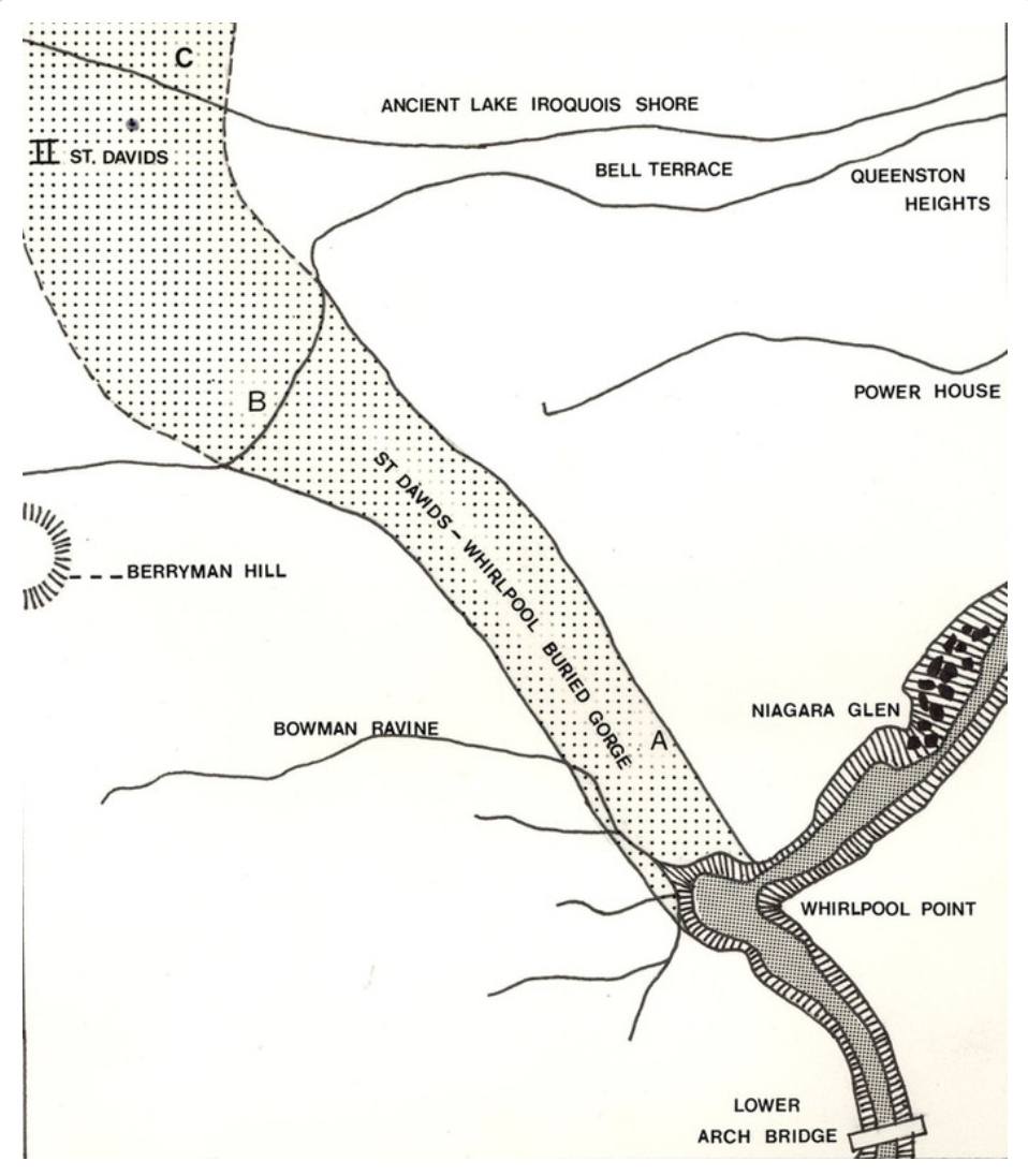
Saint David's Buried Gorge is an ancient pre-glacial river bed that existed 22,800 years ago on the present-day Niagara Peninsula. The ancient Saint David's River once flowed through this area prior to the advance of the Wisconsin glaciation during the Last Glacial Period. When the glacier retreated 12,000 years ago, the gorge and river valley were filled in with glacial silt and rocks. Approximately 4,200 years ago, the Niagara River intersected the buried gorge in the course of Niagara Falls receding toward Lake Erie. When the river encountered the glacial silt that filled the gorge, the river rapidly changed course to fill the ancient gorge and wash out most of the silt. This led to the formation of the Niagara Whirlpool. The Niagara River reclaimed the gorge and currently flows through part of the ancient gorge. The other part of the ancient gorge extends into Lake Ontario at a different point than the Niagara River. The gorge is estimated to be 4,000 ft (1,200 m) long, 1,000 ft (300 m) wide, and 300 ft (91 m) deep.In the 1950s, Ontario Hydro dug two tunnels from the upper Niagara River to supply water to the Sir Adam Beck Hydroelectric Plant. These tunnels had to surface when they encountered the St. David's Gorge, as the loose silt in it was unsuitable for tunneling. In 2013, an additional tunnel, the Niagara Tunnel Project, was completed. This tunnel was bored beneath the old gorge to avoid the unsuitable geology.
 |
| 1 |
 |
| 2 |
 |
| Dougie Jay commented on Paula's post From the same article as your coloured map. |
 |
| Dougie Jay commented on Paula's post |
 | |
|
 |
| Jim Cavanaugh posted From my Archive. A 2012 view of the lower Niagara River running from the Whirlpool to Lake Ontario. In the center is the reservoir for the Ontario Power Generation Hydroelectric Power Plant. Jim Cavanaugh shared |
Dougie Jay posted three photos with the comment: "The Adam Beck Pumped Storage Reservoir .. situated on the original Larkin Farm; 1934 & 2016 & 2017 (Google Earth)"
Walter Chew: Did it open in 2017? Thought it was older. Weird there’s no fishing access.
 |
| 1 |
 |
| 2 |
 |
| 3 |
 |
| Dougie Jay commented on Walter's comment Completed in 1955, it was drained in 2016 for maintenance (photo: Mike DiBattista) |
 |
| Bill Michell commented on Dougie's post Reservoir construction in progress before the pump station construction began. Dougie Jay: Bill Michell Carman Street, where I grew up, and the Hydro Haulage Road (future Swayze Drive) appear at the very top of this image. Our house was completed in 1953, so I'm estimating this photo to be 1952 |
 |
| Dougie Jay commented on his post 1953 (NFPL) |
 |
| Dougie Jay commented on his post The Larkin Farm in 1920 |
 |
| Bill Michell commented on Dougie's post Mid 1950's just prior to the reservoir construction |
 |
| Bill Michell commented on Dougie's post 2010 looking west from the river |
 |
| Bill Michell commented on Dougie's post 2010 Dewater for repairs |
 |
| Dougie Jay commented on his post 2015 (Google) |
 |
| Image courtesy of copyright 2000-12 OPG via power-technology Interior of the Sir Adam Beck II power generating station. |
Several references refer to "the international treaty." But none of them explain it. From memory from over 50 years ago from a Popular Science article, the treaty says that the Canadian and American power companies can divert a lot more water from the Niagara Falls at night than they can during the day. The reason they can't take a lot of water during the day is to avoid reducing the tourist spectical of water flowing over the falls. Unfortunately, people use more power during the day than they do during the night. So they built a 750 acre water reservoir. During the night they use the increased power generation to pump water into the reservoir. During the day, they release water from the reservoir to offset the water that is sent over the falls. Fortunately, the function of the pumps can be reversed and they generate power when the water is released. So the pumps increase the generating capacity of the plant during the daytime when demand is higher.
"This treaty spelled out for the first time how much water could be diverted from the river for hydro generation. It specified that a minimum 100,000 cubic feet of water per second would flow over the Falls during the day, while at night this flow would be reduced to a minimum 50,000 cubic feet per second." [NiagaraFrontier]
Because OPG has retired some of its older power stations, it was no longer using all of the water it has been allocated. And the power plant has been upgraded so that it can handle more water and generate more power. So a third water supply tunnel was finished in 2011. [power-technology]
 |
| Image courtesy of copyright 2000-12 OPG via power-technology "The 150m [492'] long, 14.4m [45'] high and 4,400t Big Becky is the largest hard rock TBM ever built." |
The third tunnel increased the capacity by 194mw. [EnergyTariffExperts]
 |
| opg_tunnel Big Becky, the world's largest tunnel boring machine. |
This is the post that motivated this research.
 |
| The Lundy's Lane Historical Society posted THE LUNDYS LANE HISTORICAL SOCIETY Proudly presents guest speaker Mr. Peter Mulcaster at its next meeting Monday June 5th. 7 p.m. Mr. Mulcaster is a retired professional Engineer currently engaged in writing a book about the extraordinary achievements surrounding the construction of the Sir Adam Beck #1 Generating Station. The presentation is entitled "The Queenston-Chippawa Power Development" "Construction of the Sir Adam Beck #1 Generating Station 1917-1922" The Lundy's Lane Historical Society shared |
R.S. Doublas posted two images with the comment: "It looks like a lot of work is going on at the Sir Adam Beck plants. There's scaffolding along the wall and a whole maze of it below. I included the video because it shows water draining down the wall, which I'd never seen before."
William Wilson: I wonder if that's the start of what's to come they're supposed to be draining the hydro canal at some point I think I have delayed due to COVID and that hasn't been done since I believe in the '80s early 80s they'll have to close the gate at McLeod road and the one up by the lake they store in and then they're going to drain the entire hydro canal throw it all the debris and yes probably the bodies and stolen property but it should be a sight to see.
 |
| 1 |
 |
| 2 |
2 of 7 photos posted by Bill Augerman with the comment: "Fall on the niagara river 📸@billaugerman"
 |
| a |
 |
| b |
2 of 3 photos posted by Karen Limardi with the comment: "Sir Adam Beck Power Station this afternoon [Dec 28, 2024]."
 |
| a |
 |
| b |
Meredith Green posted two photos with the comment: "Does anyone recognize this? Is it some sort of damn being repaired or constructed in the area? Found with photos of the Falls. Not sure of the date taken."
[The comments implies that this was Sir Adam Beck #1.]
 |
| 1 |
 |
| 2 |
 |
| Mark Wright commented on Meredith's post Compare to this image of Sir Adam Beck 2 with construction a little further along. |
 |
| Mark Wright commented on Meredith's post An 0verview of Beck #2 construction in the 1950s. |
 |
| Canada Explore posted Best view of Niagara Fall Dougie Jah shared [About a fourth of the way down on the right is the Welland River from which Canal #1 goes to the Sir Adam Beck Power Station. Below the mouth of the Welland River are the two intake towers for the tunnels that veed Canal #2 of the SAB station. The dam sticking out into the Niagara River is the International Control Structure. At night, its gates are close to divert the river's flow to the American and Canadian power stations. As the bank of the Niagara River approaches the right side of the photo we see the Ontario Power Intake. It fed a tunnel that I think went to this now removed power station. Next is the diagonal dam and intake structure for the Toronto Power Station. Finally, we see most of the diversion dam for the William B. Rankine (Niagara Parks) Power Station. Niagara History and Trivia shared |
Dianne Gibson posted three photos with the comment:
Here are a few old photos.Sir Adam Beck No1 and 2 under construction 1957-58Chippawa-Queenston Hydro canal ( official opening - 28 Dec 1921) You can almost see the 5 corners at Stamford Centre on the left... and the Cyanomid on the right.the hydro canal twisting around the whirlpool gorge and part the current golf course.
 |
| 1 |
 |
| 2 |
 |
| 3 |
 |
| Facebook Reel |
Look at all of the drills making holes for the next blast while the shovels clear out the blast debris.

posted


