Tuesday, March 29, 2022

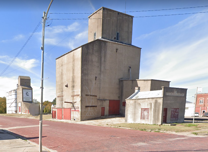
Chapman, KS: 1911 and 1917 Rectangular Concrete Grain Elevators

1911: (Satellite)
1917: (Satellite)
Wood: (Satellite)
Current: (Satellite)
 
This is an example of how a new material, concrete, was used to build something using the traditional design for a previous material, wood. Of course, concrete grain storage quickly evolved to use round silos to avoid the weakness of square corners.  

Street View, 1911 and 1917

David Erickson posted two photos with the comment:
I'm sorry I didn't spend more time in Chapman, KS.  The elevators are beauties and have been photographed and posted here over the last several years. I was glad to get a chance to see them for myself.  But, I wasn't aware of the story behind the concrete rectangular elevators in the photo on the left. [First one below.] The Poor & Knight elevator in the background on the left image dates back to 1911.  It was built to replace a burned wooden structure.  1,800 bags of concrete mix were used to construct this elevator.  It is concrete throughout and has the same rectangular profile of a wood elevator.  The Frazier concrete elevator and weigh station in the foreground of this same image was built in 1917 to replace a wooden elevator that burned down that same year.
Information found from a posting by Grain Elevator Press, 2012.

1

2

Another view of the wood elevator that is on the right side of photo #2 above.
Street View

The wood elevator is in the right background of this view. On the other side of the tracks is the current co-op.
Street View, Oct 2021

I saved a satellite image to show that a co-op has a lot more than just some grain bins so that it can provide fertilizer, seed, etc. for the farmers. According to the above street view, they removed a couple of storage buildings and added a jump-form grain silo since this satellite image was taken.
Satellite

It also looks like they removed those small bins.
Street View


Monday, March 28, 2022

Bomanville, ON: St Marys Cement Plant Loading a Freighter

(Satellite)

An hour after I saw this post a saw a post of a cement freighter being unloaded.

Janey Anderson posted three photos with the comment: "CSL TADOUSAC loading cement at St.Mary's in Bomanville. The loading chute experiences relatively no spillage or dust.  They load in hatches and use ullage to test when she's full. 30 hours to load and then off to Detroit! Thanks Shomari Marble Morgan"
Andrew Russell: Always wondered why the hatches had hatches!
Denise Robichaud: 30 hours to load cement? That's a long time. Wow ! Good thing it is probably powder.
Gary Scott: I have nothing good to say about this cargo did it a few times on this ship, the unloads were terrible.
Paul Ingram: What is vessel ullage? Ullage is the void space in the tank measured from the top of the tank to the upper surface of the fluid. Ullage is measured when the content of a tank is highly viscous and if the tank is filled to the maximum. Sounding pipe is constructed in the tank. i.e. the amount that a container (as a wine bottle or tank) lacks of being full. [I had already found that definition in a Google search. But frankly, I don't really understand it.]
John Harwood: Nobody asked yet...what process/equipment is used to unload the cement powder, since gravity is not in your favour during unloading?
John Harwood
Janey Anderson I found this link on CSL Website…looks specific to CSL Tadoussac…

1

2

3

The rotary kiln needed to make cement.
3D Satellite

The quarry from which they get the limestone.
3D Satellite

On my desktop I see this image that has a freighter at the dock. First of all, the deck is not near as clear as the freighter in the photos above. Secondly, I wanted to get a 3D view of this scene. Since that broke on my desktop a few months ago, I used my laptop to view this scene. But it doesn't have a boat! So I checked with my wife's laptop, and it also doesn't have a boat. This is the first time that I have seen Google Maps be inconsistent.
Satellite

I got curious, so I fired up Google Earth. I could not find the image that the laptops accessed. But I did find some other interesting images. This is an articulated tug and barge.
Google Earth, Apr 2017

An Oct 2016 image also had a tug+barge, but it had some cloud cover so I could not determine if it was the same as the above. Oct 2016 had a freighter that looked like the satellite image. May 2016 was empty, and May 2015 looks like the same tug+barge. Aug 2014, Sep 2007 and Dec 2005 were empty. Aug 2009 had a very poor image, but you could still tell it was a tug+barge.


Sunday, March 27, 2022

Duluth, MN: 1980 Ash Grove/Holcim/St. Lawrence Cement Terminal Unloading a Salty

(Satellite)

It was Holcim. And now (Oct 2022) the name is Ash Grove Cement Duluth Terminal.

An hour before I saw this post a saw a post of a cement freighter being loaded in Bomanville, ON..

This terminal opened in 1980. [Cody White's comment on his post]
Al Miller posted
Soo River Trader being unloaded at St. Lawrence Cement at the Duluth port terminal. Basgen Photo. Date is unknown but judging by the tidiness of the terminal grounds, this was shot not long after it opened.
Isaac Pennock: I believe the Soo River Trader brought the inaugural cargo to that dock when it opened.
Frank Jerome: Ho long does it take to unload a cement boat?
Dennis DeBruler: Frank Jerome "less than 68 hours for a 30,000 deadweight tonne vessel" https://youtu.be/bvh11ZY3cBc?t=211
Brian R. Wroblewski: What town is that in? Interesting unloading leg. How does it work? Is it still there?
Al Miller: Brian R. Wroblewski Duluth port terminal. The unloading leg is an augur.
Isaac Pennock: Brian R. Wroblewski still there and cargoes are now brought in from overseas on salties.

Dennis DeBruler replied to Brian's question
https://www.google.com/.../@46.7506039,-92.../data=!3m1!1e3
Brian R. Wroblewski: Dennis DeBruler man, that's a LOT of hardware just to unload some cement. I can't think of another cement terminal anywhere on the lakes that has anything like that. The storage terminals like Buffalo are larger too & have more bin capacity but no big unloader like that.
Dennis DeBruler: Brian R. Wroblewski I think the key is Isaac Pennock's comment that this terminal can handle salties. The other Great Lakes cement terminals that I have seen need either self-unloading or pneumatic unloading ships.

David Schauer posted
Federal Hunter continuing its unload of cement at Ash Grove in Duluth as the rising sun casts color on clouds above. After unloading, the Federal Hunter will head to Thunder Bay. 10/9/2022
Tim Smith: When did the ownership change from Holcim?
David Schauer: Tim Smith Within the past few years as part of a sell off of assets to gain merger approval.

David Schauer posted
Busy Port...
The Hon. James L. Oberstar departs after unloading stone at Envirotech-Hallett Dock 8 in Superior. Federal Churchill is unloading cement while the Federal Kushiro and Fagelgracht are moored at the port terminal. 8/4/2022

Paul Scinocca Photography posted
GL Ostrander / Integrity arriving Fraser Shipyard Drydock this Tuesday November 15. Coming into the dock along with a snow squall and with the Heritage Marine Tug Helen H riding "shotgun". They arrived Duluth Nov 13 @ 07:05 for Holcim with cement powder from Alpena, MI. After discharging they sailed to the Fraser drydock for their 5 year inspection.
Paul Scinocca Photography shared
 
David Schauer posted
Soft morning light bathes the ATB Ostrander/Integrity at the Holcim cement dock Sunday morning. A day when there were two vessels named Integrity in town (American Integrity was at the fuel dock). Superior, WI - June 11, 2023
Nathan Leindecker: The steamboat killer and her prey. [Articulated Tug Barges are becoming more common as MRC cuts up more freighters.]

The magic of YouTube's AI offered this video. It can unload 900 metric tons per hour.
4:13 video @ 0:15

Detroit, MI: Mistersky Refueling Dock and 1927-2010 189mw Power Station

(3D Satellite, the tank farm occupies the former coal storage pile area)

The power plant was converted from coal to fuel oil and natural gas. Once converted, the land for the coal pile storage became obsolete. So they repurposed it into a tank farm. In fact the tank farm probably helped supply the power plant. The power plant is now closed, but the tank farm lives on as a ship refueling facility. It can accommodate the footers (Great Lakes ships over 1000' long).

Andrew Dean Detroit posted five photos with the comment:
James R. Barker fueling up at the Mistersky Dock.
Detroit, Michigan
8/14/2021
Roger Riblett shared
1
Forrest Erkkila: If the boat is low on fuel how long does it take to fill it up?
Andrew Dean Detroit: Forrest Erkkila maybe around 5-8 hours, at times I’ve seen tug barges come around and help fuel them as well.

2

3

4

5


Detroit Public Library
View of the Mistersky Power Plant located at W. Jefferson Avenue and Junction. Sign in front of building reads: "Capital Improvement Program. The City of Detroit. The Mayor and Common Council." Stamped on back: "Detroit City Plan Commission. Photograph by Harold Raymond." Handwritten on back: "Mistersky Power Plant addition. W. Jefferson & Junction."

This table would be as of the time it closed because it started with coal. 189mw
PowerTypeStatusFuel
35 MWBurner: TurbineClosedOil
44 MWClosedNatural Gas
50 MWClosedNatural Gas
60 MWClosedNatural Gas

"In 1927, all electrical generation was transferred to the Mistersky Power Station on West Jefferson Avenue, which had a capacity of 60,000 kilowatts. Through period expansion, the electrical generating capacity of the Mistersky Power Station was increased to 184,000 kilowatts by 1979. A power interchange line of 80,000 kilowatts capacity connects Mistersky to the Detroit Edison Company." [rpwrhs, License: Creative Commons Attribution-NonCommercial-NoDerivativeWorks (CC BY-NC-ND)]

Street View

I wonder what the gizmo on the left side of this view did.
Street View

It must have operated until at least 2010 because I see gasses coming out of one of the older smokestacks. In fact, this has to be one of the last photos taken while the plant was operating because it was decommissioned in 2010. [ScenarioJournal]
Photo published by Diane Bukowski on Oct 28, 2010, via VoiceOfDetroit
Mistersky Power Station photographed from across the Detroit River in Windsor, Ontario, Canada. This is the public lighting department power plant for Detroit.
"Photographed on Kodak Ektar 100 film using a NIkon F5 and a NIkkor 80-400mm VR lens."

This photo is also in DetroitArchitectJournal

Rick Flickr, 2016
This is the Mistersky Power Plant in Detroit. It was formerly the power station for the public lighting system.
Photographed using a Sony A7R with a Nikkor 43-86mm f/3.5 lens.

This power plant appears to be a subject that Rick likes to take.
Rick Flickr, 2012
The old Mistersky power plant is along the Detroit River.
Photographed using a Nikon F5 with the Nikkor 18-300mm VR lens on Kodak Ektar 100 film.

Two of the interior photos in DetroitArchitectJournal.
a

b

The question of when they converted from coal to oil motivated me to try again to learn the USGS EarthExplorer to get historical aerial photos because HistoricAerials is now copyrighted. I had better luck this time. We can see that it was still using coal in 1966.
1966 @ 24,000
I had to rotate it 180 degrees because they don't always have North at the top.

By1973, the east side had been converted to tanks, but they still had coal piled on the west side.
1973 @ 24,000

I include an available 1951 shot because it shows that the emissions from the smokestack can be really black before regulations required air scrubbers.
1951 @ 23,600

ScenarioJournal

I've passed up a lot of photos of freighters being refueled at this dock. But I note these photos because it is unusual to see all of the tug. Normally, they are connected to their barge. For photos of a pair in action, checkout Laura L. Van EnKevort captured on her first visit to the Twin Ports. And here is a 0:31 video of Clyde S VanEnkefort pairing up with its barge.
Andrew Dean Detroit posted two photos with the comment:
Clyde S. Vanenkevort grabbing fuel at Mistersky, a rare treat to see this Tug out of its Barge.
4/7/2022
Detroit, Mi
Andrew Dean Detroit shared
VanEnkevort Tug & Barge Inc shared
1

2

8 photos of the Arthur M Anderson topping off

Saturday, March 26, 2022

Tuttle, ND: Old Gas Station and Old Grain Elevator

Gas Station: (Satellite)
Grain Elevator: (Satellite)

While looking for the grain elevator, this "signature" photo that Google Maps chose for the town caught my eye. I don't see too many of these really old gas stations. This one is rather fancy because it has a service bay on the side. And it has done at least one upgrade of its gas pumps. The station was probably built during the first half of the twentieth century, but the pump is from the second half. It is on the corner of Main Street and the State Highway (ND-36)
Photo, Mar 2020

I can get a better view of the service bay with street view. I looked for a replacement gas station in this town, but I could not find any. I wonder how far people now have to go to get gas.
Street View

I've been skipping photos of old wood grain elevators because of a time crunch. But the fact that this one is still being used made it worthy of note. And helped me find another old gas station.
Edward Dukek posted
Cody Mack: Good old elevator, built in 1915 and still operated as a coop today. They buy grain, sell grain for feed and seed, fuel, gas, oil, propane, grease, chemicals, mineral, lumber, and I believe some hardware too (nails, screws, bolts, hinges) I live down the road to the east about 20 miles. We take oats seed over every spring to get cleaned. I enjoy going to and doing business with this elevator.
John Harker: ND State Hwy 36 from Pingree to Wilson is a hidden gem of Central North Dakota.
Cody Mack: John Harker I agree. A few towns still have lots going for them, Pettibone and Tuttle being two. Wing still has a movie theater, Woodworth a good size grain elevator and a great cafe, Robinson a good cafe as well.

Street View

I include an overview to show that a full-service Co-op has to store a lot of miscellaneous dry products.
Street View

They would store grain that is harvested in the three big bins that I included in my overview in the top street view. This view catches the auger grain elevator that they would use to fill those bins.
Street View

We can see from the land scars on the east and west sides of the town that the new cluster of small bins was built on the right-of-way of the Northern Pacific Railroad that used to service this town.
Satellite


Friday, March 25, 2022

New York City, NY: Building the Empire State Building

(Satellite)

I'm sure that everyone interested in industrial history knows that at one time the Empire State Building was once the world's tallest building. And that it was the development of a steel frame and curtain walls that made skyscrapers possible. But I did not know that it was built in only 13.5 months. Now days, it probably takes that long to prepare the environmental impact statement.

safe_image for Stunning footage of the construction of New York's Empire State Building in color (opened in 1931)

The first part of the video shows them fabricating something in a shop and then lifting it into place. I did not understand that it was the base of a column until I saw this scene.
Screenshot @ 8:33

Chris Nicholson commented on the Facebook "safe_image" post
Living in limestone quarry land I thought I would share a picture of the quarry where the stone for the Empire State building came from. When any needs replaced this is where they go for it.
Bedford Indiana
James Torgeson: Chris Nicholson Exactly what had to be done when the Pentagon was rebuilt after 9/11.
Chris Nicholson: James Torgeson yep. The pentagon hole is is not too far from this one. One of the area mills, Bybee Stone still has operational saws that are over a century old. They can cut the slabs to the same texture required for those old buildings.
 
New York Memories posted
Empire State Building under construction in 1930

𝗥𝗲𝗺𝗲𝗺𝗯𝗲𝗿 𝗪𝗵𝗲𝗻: 𝗡𝗲𝘄 𝗝𝗲𝗿𝘀𝗲𝘆 & 𝗡𝗲𝘄 𝗬𝗼𝗿𝗸 posted
In 1930: Construction worker Bob Fitzpatrick secures himself to a metal girder on the 102nd floor of the Empire State Building to make some technical checks! 
Loc: New York
Jöjö Corcilles: The caption is completely inaccurate. There were no hard hats in 1930, they didn't start entering the trades until the 50s, and not mandatory until the 70s mostly everywhere, therefore, I put the picture somewhere around 1957 to 1963.
[Other comments explain that he is using a spud wrench to align rivet holes and is wearing an American Bridge hard hat. So this would not be the Empire State Building.]
Nick Breznai shared
 
𝓚𝓪𝓽𝓱𝓲 posted
Incredible Photos Show the Terrifying Conditions for Empire State Building Construction Workers in the 1930s.
 
100k posted
Empire State Building, New York, 1931

The World posted
The Empire State Building in New York City under construction in 1931.

I didn't know a bomber crashed into it.
Images of Yore posted
The aftermath from a B-25 bomber crashing into the Empire State Building (1945)
Richard Mousner: Betty Lou Oliver, the elevator operator, rode the elevator down 75 stories when the cables were cut...and lived. [Another comment said she went down 1000'. So I guess this is true. Why didn't safety locks stop the car? Or does the Otis safety device simply limit the speed? Otherwise, if it was a lock, how would the car normally go down?]