Mine #3: (Satellite, the land with no trees was the base of the tailings pile)
Mine #1
This mine was active between 1884-1925.
 |
| Roger Kujawa posted Spring Valley, Illinois Coal Company Mine 1. Jeremy Bubb: Serviced by Rock Island? Harold J. Krewer: The No. 1 and No. 2 mines were in the valley of Spring Creek and served by the C&NW. The No. 3 mine was on the west end of town. The North Western built a long spur through town to serve it and it was also served by the Chicago, Ottawa & Peoria Railway, an electric interurban line that was part of the Illinois Traction (later Illinois Terminal) System. Roger Kujawa shared Dennis DeBruler Judging from the "white mountain" in the background of the photo, we are looking north. I have learned that C&NW served three coal mines on the west side of Spring Valley. So I assume this is one of them. |
 |
| Roger Kujawa posted 1914 Spring Valley Illinois postcard, miners, mining, mine, IL |
Andy Zukowski posted three photos with the comment:
Spring Valley Coal Company, Spring Valley No. 1 Mine, Bureau County, Illinois.
The Spring Valley Coal Company owned four mines in Spring Valley. By 1913 there were 2,500 miners working through the Spring Valley Coal Company's four mines. Mine No. 1 closed in 1923 and was dismantled in 1927.
 |
| 1 |
 |
| 2 |
 |
| 3 |
 |
| Roger Kujawa posted Spring Valley Illinois Coal Co. Mine PC Miners ~1900's Bureau County IL RR cars. Looking South towards the Illinois River. Served by the C&NW. Roger Kujawa shared Ken Morrison: so is that the Rock Island trestle over Spring Creek (and the CNW) behind it? Roger Kujawa: Ken Morrison That would be the interurban. Chicago Ottawa and Peoria. Also at one time the Chicago and Illinois Valley. |
 |
| Dennis DeBruler commented on Roger's share It appears the tipple was at the end of Iowa Street. 1913 La Salle Quadrangle @ 1:62,500 |
Roger Kujawa posted three photos with the comment: "Spring Valley Illinois postcard 1910? Mine #1 Coal Mine And rescue team."
 |
| 1 Roger Kujawa posted Spring Valley Illinois postcard 1910? Mine #1 Coal Mine |
 |
| 2 |
 |
| 3 |
This looks like a variant of photo #2 above.
.jpg) |
| Roger Kujawa posted 1908 No. 1 Coal Mines Spring Valley Illinois Ill. Postcard Gary Gray: Probably using 5 ton skips That means their max was around 3000 tons per 8 hours. |
 |
| Andy Zukowski posted Shaft NO. 1 in Spring Valley, Illinois. |
 |
| Jay Davis posted IL Illinois Spring Valley Coal Mining Mine #1 & Refuse Dump 1909 Postcard seen on eBay. Repost |
5 newspaper clippings
Mine #3
 |
| Andy Zukowski posted Spring Valley Coal Co. Mine NO.3 Spring Valley, Illinois. 1920’s Kevan Davis: Is all the wood inbound for cribbing? Leroy Raney: Kevan Davis propping roof for support. |
.jpg) |
| Roger Kujawa posted Spring Valley, IL-Illinois, No. 3 Coal Mines c1910, Vintage Postcard |
 |
| Dennis DeBruler commented on Roger's post On this topo map, we can clearly see where the tailings pile was south of Northwestern Street and west of Pulaski Street. Looking at a satellite map, it appears that the pile has been removed but that trees can't grow there. 1947 La Salle Quad @ 62,500 |
 |
| Dennis DeBruler commented on Roger's post This 1941 aerial photo confirms that the topo map is correct: not only have the roads changed, but a cluster of houses was removed. https://clearinghouse.isgs.illinois.edu/webdocs/ilhap/county/data/bureau/flight9/00rr2b157.jpg |
 |
| Dennis DeBruler commented on Roger's post But I noticed that the topo map did not agree with what we see on a satellite image. So I checked out that area as well. The topo map is wrong on that detail. https://clearinghouse.isgs.illinois.edu/webdocs/ilhap/county/data/bureau/flight9/00rr2b157.jpg |
General
There were a couple of surprises in the directory. One was that longwall mining was used. I thought that was a recent development. Looking at the key, what is new is that they don't bother to backfill with rock to provide support, they just allow the roof to collapse. The second surprise was the Colchester seam. I'm used to seeing Herrin or Springfield.
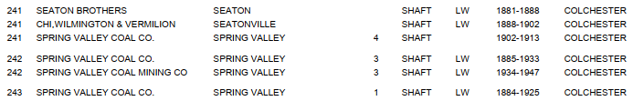 |
| Directory |
 |
| Map |
I wondered if the Colchester seam was older or newer than the Herrin and Springfield. The following shows it is older. The Colchester seam is more ubiquitous in the Illinois Basin, but it is not as thick.
 |
| ISGS, p11 |
 |
| ISGS, p12 |
The Spring Valley mines are along the northern border of the Illinois Basin.
 |
| ISGS, p13 |
 |
| ISGS, p14 |
I don't have any overview notes of Illinois coal mining, so I'm going to "park" this here for now.
 |
| David Hahn posted Copied from the “You grew up in LaSalle - Peru” fb group. |
.jpg) |
| Andy Zukowski posted Miners ready for work in Spring Valley, Illinois. (No Date) |
No comments:
Post a Comment