Wednesday, December 6, 2023

Mishawaka, IN: 1831 St. Joseph Iron Works

(Satellite)

I had no idea that there was iron ore in northern Indiana.

Tee Ray posted three photos with the comment:
Mishawaka - Founding
In 1830’s a Businessman from Detroit,  Alanson M. Hurd, sent a Prospector/Scout to explore the banks of the Saint Joe River. He found large deposits of Bog Iron in the large, swampy area South of what would become Mishawaka. 
Settlers arriving to mine the deposits founded the town of St. Joseph Iron Works in 1831. Mr. Hurd financed the building of Blast Furnace near the banks of the St. Joe River on what is now the 300 block of N. Main Street. Within a few years, the town had a blast furnace, the 1st in Indiana, a general store, a tavern, and boarding house with about 200 residents.
At the same time, Developers, Joseph Battell, James R. Lawrence and Grove Lawrence began platting out the North bank of the River. They named this area Indiana City  and registered it on June 28, 1836. Ultimately, Joseph Battell gifted the original Plat to the City of Mishawaka to be used as a park. Battell Park was born in 1881. 
Business prospered, and in 1833 St. Joseph Iron Works, Indiana City, and two other adjacent small towns were incorporated to form the City of Mishawaka.
Excerpt: Wikipedia & The History Museum
James Torgeson shared
1

2

3

The industrial spur to the mill came across the river from the northern NYC route, which was a Big Four route.
1958 South Bend East Quad @ 24,000

A mill built in the 1830s would have used water power. 
1958 South Bend East Quad @ 24,000

Some of the headrace still exists. But now it feeds a water fountain instead of a mill.
Street View, May 2016

Dennis DeBruler commented on James share [AR1PK0000040041]
1951 aerial
An 1830s mill would have used water power. Remnants of the headrace now feed a water fountain north of Ironworks Ave.
  https://www.google.com/maps/@41.6644636,-86.1824513,201m/data=!3m1!1e3?entry=ttu

Gilbert, IA: Lost/C&NW Depot, Old Grain Elevators and WRP Lagoons

Depot: (Satellite, according to the topo map, it was south of 2nd and west of the mainline. When a building exists, Google Map won't let me drop a pin.)
South Elevator: (Satellite)
North Elevator: (Satellite)
Lagoons: (Satellite)

Chicago & North Western Historical Society posted
Someone wanted to see a photo of the C&NW in Gilbert, Iowa. Here is one such photo from a 1910s photo postcard. Gilbert is located about 15 or so miles to the north of Ames. The line still exists.

1975 Ames West Quad @ 24,000

Street View, Jul 2013

By 2016, the wood elevator was gone.
Street View, Sep 2016

The northern facility is a feed mill. Their website indicates that they carry the Purina brand. I'm surprised that I could not find Purina's checkerboard logo on any of the buildings.
Street View, Sep 2021

I saved the satellite image because it still has the wooden elevator. That means that it is older than Sep 2016.
Satellite

The tracks not only still exist in this town, they are still owned by UP rather than a shortline. Thus the elevator doesn't have rail service. But rail service is not important for a feed mill.


Tuesday, December 5, 2023

Clinton C: Albers, IL: 1977-96 Monterey #2 Coal Mine Lost/Southern Depot

Mine: (Satellite, this was the loadout. The tipple was south of this.)
Southern Depot: (Satellite)

Frank Dolezal posted, cropped
Eric Michael Stepp: Did this coal mine have any affiliation with the Monterey coal mine in east Lynn wv?
Frank Dolezal: Eric Michael Stepp yes..all owned by Exxon at the time.
[Some comments indicate that others have a copy of this painting.]
Dennis DeBruler commented on Frank's post
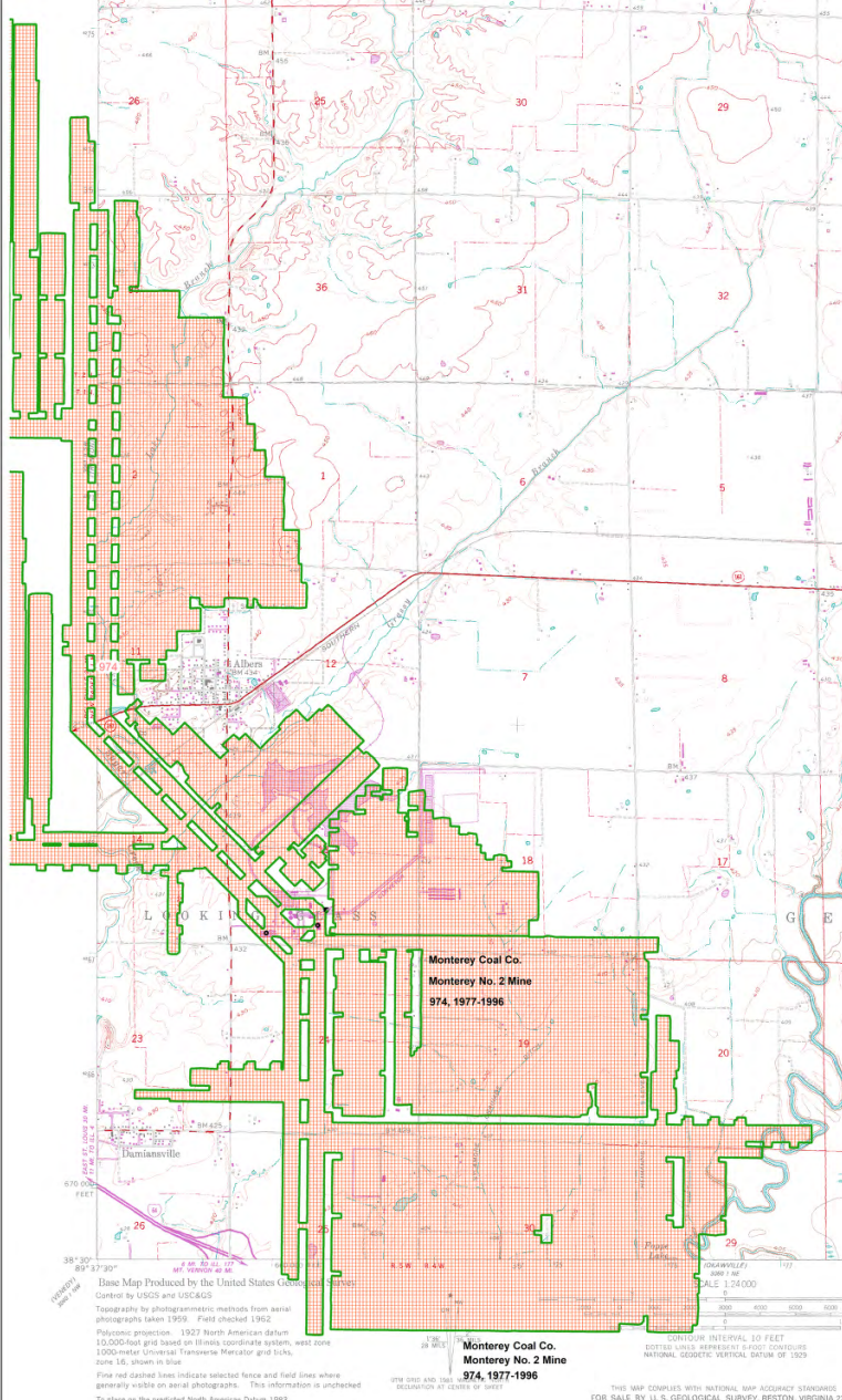
1981 Breese Quad @ 24,000
It operated 1977-96.
https://wikiimage.isgs.illinois.edu/ilmines/webfiles/topo-mines/breese.pdf
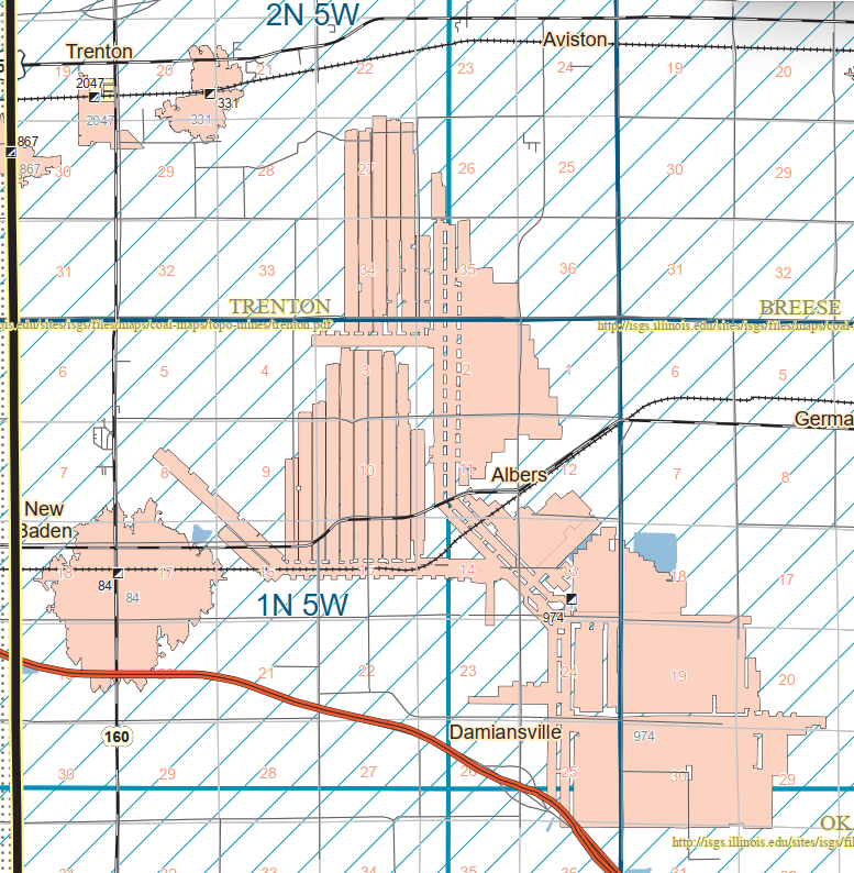
County Map

Some of their waste ponds are still present even though they supposedly reclaimed the site between 2005 and 2007. [gem]
Satellite

Just a couple of years after it closed.
Google Earth, Apr 1998

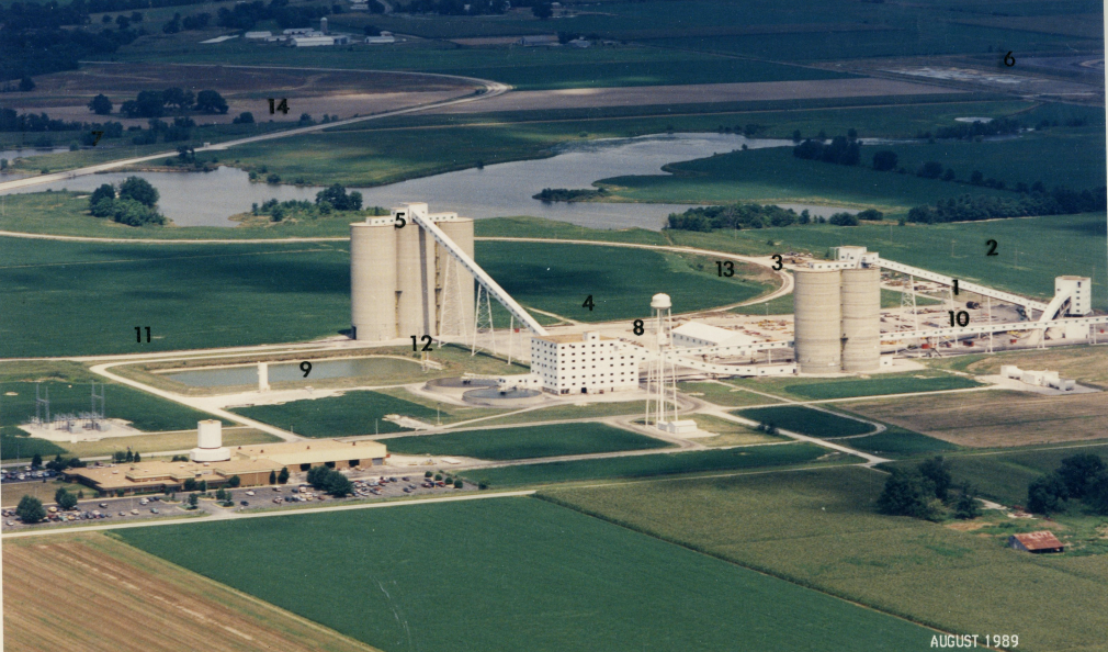
ilmineswiki, p39; pages 41-45 describe what the numbers are highlighting.

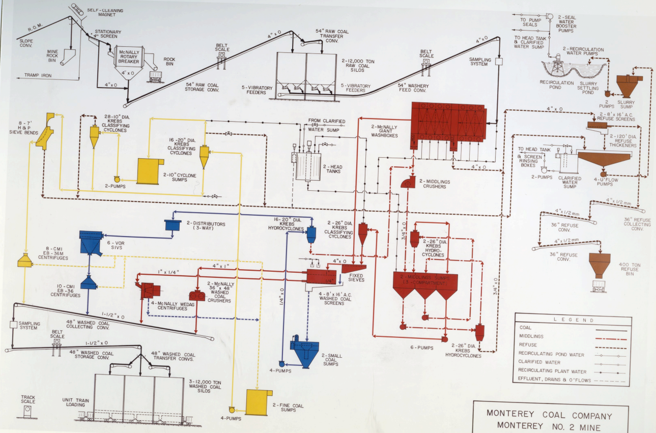
ilmineswiki, p40

John Heyen posted

Illinois EPA prepared a fact sheet about the groundwater contamination.

Andy Zukowski posted
Southern Railroad Depot in Albers, Illinois. 1956
Larry Candilas: MP 38.0 St Louis Div

Dennis DeBruler commented on Andy's post
The foundation is extant, and it is used for storage. https://maps.app.goo.gl/vxUVAyTTGHCT2v2J6

It looks like there may be a smudge in the northeast quadrant of Commercial Street and the tracks.
1938 Aerial Photo from ILHAP

Fortunately, it was still standing in 1968 so that I could confirm the location.
1968 Aerial Photo

Another view of the foundation.
Street View, Nov 2023

Croton-On-Hudson, NY: Metro North/NYC Harmon Railyard and Roundhouse

(Satellite)

Skipper L Swartout posted
New York Central Henry Dreyfuss Hudsons Roundhouse at Harmon, NY. Two workmen on top of the Second Hudson. The other guy [is] at the drivers   

A residential area now sets on roundhouse land, and a former residential area is now bare land. Perhaps that former residential area was a campground.
1938 Haverstraw Quad @ 24,000

EarthExplorer: Apr 15, 1953; AR1XI0000030042
Dennis DeBruler commented on Skipper's post
According to a 1938 topo map and this 1953 aerial, the big roundhouse was in today's residential area.
 https://maps.app.goo.gl/ei83AeuMfg8EAiDh8

John Lee posted
Croton Harmon 8.16.49.main line on the right. Upper right is old loop track to the shop side of the yard. Unknown photographer.
Dennis A. Livesey: The last steam run out of Harmon was S-1 #6020 on 8-17-1953.
Look at the roundhouse; doors are shut and the smokejacks are removed. Outside of two possible steam locomotive hulks on the storage track north of the shop, there is zero evidence of steam activity.
I would say post-1954. What do you think Howard Pincus?
Howard Pincus: Dennis A. Livesey Late 50s- very early 60s
Howard Pincus: Not so sure about that 1949 date- I see at least one RDC, and those look like P-motors next to the electric locomotive inspection shed (which burned down about 1962).
John Lee: The date was on the photo when I got it. So your opinion could be right.

Gerry Meyle Sr. posted
61 years ago today. NYC's Harmon shops with S3 897, GP7 5766, S4 8595 and more. August 10, 1963. Hal Smith photo, from my collection.

Monday, December 4, 2023

Macoupin C: Carlinville, IL: Shay/Monterey #1 Coal Mine

(Satellite)

James S. Wilson posted
Monterey no.1 mine prep plant and clean coal silos. Abandoned mine.
Dale Smith: Identical plant in Wayne County West Virginia .
James S. Wilson: Dale Smith both owned by EXXON.
Dale Smith: James S. Wilson yes

James S. Wilson posted
Monterey #1 mine prep plant and clean coal silos.
Jim Knope: They call it the Shay mine now. Still in operation [Sep 2025]
Bob Baum: Best mining conditions ever seen. Limestone top. 3ft roof bolts.
James S. Wilson: Bob Baum 30 inch bolts in limestone. Entries around longwall panels had 12 foot pins with wire mesh.
Jim Lucas: They spared no expense- worked 2 shaft drilling jobs on #1.
James S. Wilson: Jim Lucas it was an EXXON mine, they had deep pockets.

Jim Yasinski commented on James' post
Monterey on 08/18/2007.

Dennis DeBruler commented on James' post

Dennis DeBruler commented on James' post
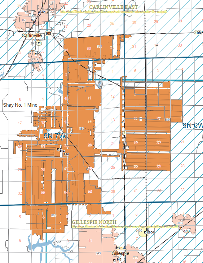
https://wikiimage.isgs.illinois.edu/ilmines/webfiles/topo-mines/gillespie-north.pdf

Dennis DeBruler commented on James' post

Dennis DeBruler commented on James' post
An Illinois Terminal remnant provided access to the C&NW route. UP owned the C&NW north to 
their former-GM&O route whereas NS owned it south to their former-Wabash line. Topo and USGS maps.

Satellite

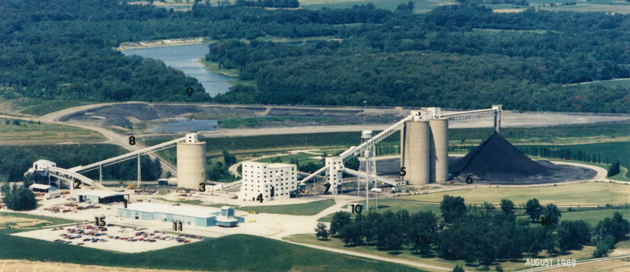
ilmineswiki, p21; pages 23-27 describe what the numbers highlight.

 Roger Kujawa posted four photos with the comment: "Monterey Mine (Shay Coal Company)."
Dennis DeBruler: I found the mine: https://maps.app.goo.gl/yVTzn8Cr6obLRyd66
1

2

3

4

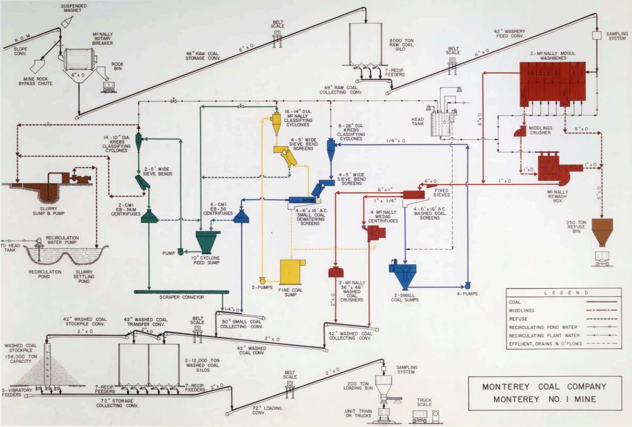
ilmineswiki, p22

John Heyen posted


Jefferson, IA: Trail Head/Milwaukee Depot and Old Grain Elevator

Depot: (Satellite)
Elevator: (Satellite)

Street View, Aug 2021

Chris Munson posted three photos with the comment: "Jefferson, Iowa, Nov. 19th 2023. It's these kind of random discoveries I truly enjoy...very early 1900's Milwaukee Road station carefully restored, with the adjacent former roadbed long since converted to a walkable trail. Could find no evidence of former roadbed North of this location, other than a pretty solid tree line. Do not know if this rail once crossed the (now UP) double track main which runs through town East and West."
[Several comments discuss other towns that had a similar designed Milwaukee depot.]
1

2

3

Dennis DeBruler commented on Chris' post
The Milwaukee not only crossed the C&NW at the northeast corner of Jefferson, it crossed another C&NW route at the northeast corner of Lohrville.
1958 Fort Dodge Quad @ 250,000

Michael Emerson Avitt posted
August 9, 2008 - CMStP&P depot at Jefferson, Iowa.

Jim Arvites posted
View of the old Milwaukee Road passenger depot at Jefferson, Iowa taken on July 15, 2019. The station, built in 1901, has been restored and is still standing today.
(Jim Arvites Photo)