Tuesday, March 24, 2020

Gibson City, IL: Grain Elevators

Alliance Grain and One Earth Energy: (Satellite)
Cargill: (Satellite)
Original Alliance Grain: (Satellite)

I've already documented the soybean processing plant in this city.

Alliance Grain


Junior Hill posted
Two Bloomer Line RR Geeps and a GP35 leaser work the big elevator at Gibson City, IL, on a frigid January day. 1/4/2018
Junior Hill Dennis DeBruler It's just west of town along the NS[/NKP/LE&W]. Bloomer actually has to briefly run on NS to get to this isolated section.
Satellite
I presume it shares the railyard with the ethanol plant.

I wonder if it also shares the two locomotives.
Satellite

Cerita Sakura posted
Running what you got, The Bloomer Line's SW1200 isn't what you would expect to find pulling a loaded grain train with a pair of GP9s but it works for this flat land based granger operation. BLOL 92 is pulling their train through the grain elevator to interchange the train to the ICRR at Gibson City, Illinois. April 17th, 1997.
Photo Credit to Paul M. Rome.
Richard Fiedler shared

Jesse B. Hill posted
Bloomer Line RR has just dropped a cut of covered hoppers at Alliance Grain and is now heading out of the plant lite so they can retrieve more cars. Gibson City, IL. 1/4/2018

Michael Krejci posted four photos with the comment: "First post. I hope the group approves. On my way home from Florida I was looking around Gibson City and noticed this elevator. I went to get a picture and saw the locomotive. Not sure of what I found I checked the emergency sign a little north of town. At home I Googled Bloomer Lines and found some interesting info. https://www.alliance-grain.com/fccp-the-bloomer-line-17013"
Paul Jones: That's the 7549, it's a former NYC unit, still has its 24rl brakes, drum controller, long hood forward set up, steam boiler replaced by a big block of concrete in the short hood and water tanks underneath are additional fuel tanks now. Built in 55 runs daily switching the ethanol plant and loading grain at the elevator.
Tom Dueringer: My Hometown elevator. Also in Gibson City is an ethanol plant (One Earth Energy) a Cargill Elevator & DuPont Nutrition & health plant
1

2

3
Along Rt. 47

4
Interesting transload spot.
Paul Jones: That's a unloading auger for over weight rail cars. Track scale .

Noah Haggerty posted
AEQX 810200, Ex-KO 182437 Exx-CNW 182437
September 16, 2023
Gibson City, IL

1 of 7 photos posted by Matt Kohnen
Made a stop at Gibson City, IL to take a look at the Bloomer Railroad. Looks like mostly everyone is at the shop.


Cargill

Paul Jones commented on a post: "Cargil in Gibson City loaded 100 car trains back in the 60's and 70's also developed the first 100 ton hoppers in conjunction with the I.C. I believe."

Cargill has access to both NS/NKP/LE&W (top) and CN/IC (bottom).
Satellite

Original Alliance Grain


Satellite
This must have been the original Alliance Grain elevator and the one out west is a greenfield expansion.
Street View
Given the little switcher and the fall protector, the Bloomer Line must do some rail service here. That is an advantage of a shortline railroad, many are willing to build a unit train by servicing smaller elevators. Servicing the eight Alliance Grain elevators on its route is one of the main missions of the Bloomer Line. [alliance-grain]
Street View

Sam Carlson posted
4/17/19 at Gibson City, IL

Miscellaneous

Sam Carlson posted
Bloomer in Gibson City, IL.n Arrrpril 17, 2019. This really sounded GOOD!

Monday, March 23, 2020

Remington, IN: Large, but closed, grain elevator, Preserved/TP&W/Pennsy Depot and 1897 Utility Water Tower

Elevator: (Satellite)
Depot: (Satellite, "event venue")
Water Tower: (Satellite)

Brett Ellis posted four photos with the comment:
This was Remington Coop in Remington Indiana. It became Co Alliance. Remington had a second elevator in Goodland In. that has been torn down. This elevator was at one time a 100 car shipper that's been closed. Reason given was too expensive to bring up to safety standards. There was also a large steel tank that's been removed.

Bob Summers Likely another reason for the closure is back in the day concrete elevators were engineered for filling and emptying te fins only a few times a year and the structural forces encountered with frequent repeated filling and emptying the bins as would be required if frequently loading 100 car trains causes structural problems over time.
Brett Ellis Bob Summers they said in a release a lot was due to dust control etc but what you're saying definitely makes sense.
Bob Summers Dust control systems to meet EPA & OSHA in closed elevators these days are very expensive, so no doubt another factor in their decision not to put more money into this facility.
Rich Reed I can understand OSHA. My grandpa who worked in the Davidson elevator in Hutch had to have his nostrils cleaned out from the dust. Also explosion issues. Why would EPA be an issue. Or is it like the Hutch Hospital being 6 blocks from the ADM north elevator in Hutch.
Bob Summers Rich Reed EPA is concerned with emissions outside the facility that affect our air quality. OSHA is concerned with health and safety of personnel in the facility
Dennis DeBruler Rich Reed What is the issue with the hospital being a little west of ADM?
https://www.google.com/.../data=!3m1!1e3!4m5!3m4...
Rich Reed Dennis DeBruler a guy told me the elevator had to have a dust system to avoid exhausting dust over the hospital and causing a ruckus.
Bob Summers Rich Reed EPA regulations applying to grain handling facilities became a major factor in the mid - late '70's and have been made more stringent several times over the years. Collinwood might have gone a litle above the regulations as a PR move because of the hospital, but with our prevaling winds not being out of the east in this area, the proximity of the hospital should not have been an issue.
Dennis DeBruler I see that the elevator has just a couple of short sidings. I know that the Toledo, Peoria & Western shortline is very grain elevator friendly. But maybe they now have enough business that they don't want their mainline tied up with a unit train being loaded. The Prairie Central Coop in Illinois built a new elevator with a balloon track to load unit trains on their own property.
https://towns-and-nature.blogspot.com/.../chenoa-il...
Dennis DeBruler A fourth strike against this elevator might be that many of the farmers in this area have switched to growing seed corn. The seed companies have their own storage facilities because the corn is air dried on the cob because the heat of a regular grain dryer would kill the germ in the kernel.
https://industrialscenery.blogspot.com/.../hybrid-corn...
Brett Ellis Dennis DeBruler that first hit them years ago and definitely impacted business.
1

2

3

4

Dennis DeBruler commented on Brett's post
A satellite image still shows the steel bin. Can the steel be unbolted and used at another elevator?

I've noticed that, as of 2020, the Google Image copyright no longer seems to be accurate.
https://www.google.com/.../@40.7608641,-87.../data=!3m1!1e3

Depot


Locomotive Jordon posted
Early to mid 1990's, we look east through downtown Remington, IN. on the T P & W's former PRR Effner Branch. We see the former PRR depot that was formerly home base for the TPW m-o-w crews for many years. I spent a few years tagging along with the TPW track guys on my off days from my regular railroad jobs. Always had a good time and learned more than I did with the railroads that I worked for.
Tim Shanahan shared

Street View, Jul 2024

Utility Water Tower


Street View, Jul 2024

Jay Conley, Sep 2022

Sunday, March 22, 2020

St. Clair C: Mascoutah, IL: Kolb, Home and Schubert Coal Mines

Kolb: (Satellite)
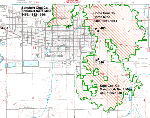
Home: (Satellite, note that Mine Road north of the tree clump is where the L&N spur ran)
Schubert: (Satellite, southwest corner of Main and Railway Streets)

While looking for remnants of the mines on the satellite map, I noticed that Mascoutah is the home of the $300m aiport that serves 4 airplaines a WEEK.

All of these mines were room and pillar.

Kolb Mine


Roger Kujawa posted
The above postcard is a colorization of the photo that appears on page 61 of eBook.
Wayne's World of History & Genealogy
"Tipple at Kolb Mine, Mascoutah, Ill.
[Coal Age, Vol. 12 No. 18, New York, November 3, 1917]"
Larry Joe Jenkel posted

Wayne's World of History & Genealogy
"Concrete Fan House at Kolb Mine, Mascoutah, Ill.
[Coal Age, Vol. 12 No. 18, New York, November 3, 1917]"

Directory
The shaft was 6'x12'. Between 1895 and 1930 it produced 3,096,758 tons. The Herrin seam was 160' deep and the thickness varied between 6' and 8' with an average of 7'. [ISGS-Kolb]

Home Mine (Opened in 1912 as Kolb Coal Co. Mascoutah #2)


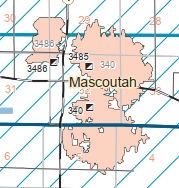
The ISGS could not distinguish the boundary between Kolb and Home Mines, that is why there is just a 340 polyogn of 978 acres in the first map below.

Directory
The shaft was 7'x16'. Between 1912-1934 it produced 2,527,015. Most of that production was before 1934 while it was owned by the Kolb Coal Co. The Herrin seam was between 160-185 feet deep and the thickness varied between 6.5' and 9' with an average of 7.67'. [ISGS-Home]


Schubert Mine


Directory
The shaft was 5'x10' and 155 acres were mined. Between sometime probably in the 1870s and 1956 it produced 864,128 tons. The Herrin seam was between 157-165 feet deep and the thickness varied between 6.5' and 7.5' with an average of 7'. [ISGS-Schubert]


Abandoned L&N Spurs


Map

Topo
The Abandoned RR Map shows that the L&N ran along the south side of town where the L&N Ave. is now. CSX tore up the west end of the L&N route before it sold it to the Evansville Western Railway. I assume that CSX did this to avoid competition for freight traffic to St. Louis and western railroads. This route would have been an attractive bypass of Chicago congestion for freight traffic from the Southeast to the West.
Abandoned Railroad Map
The Kolb tipple was built along the L&N so it did not need a spur. In fact, it supplied coal for the L&N trains. [eBook, page 62] It was abandoned for a decade by the time this historic aerial was taken. We can see the spur on the east side that ran north to the Home Mine with a yard to the north of the mine. There was a spur that curved up to Market Street and worked its way to the Schubert Mine. Note that the railroad ran on Market Street instead of Railway Street. There is also a spur in the middle that probably went to an industry in the early 1900s. Judging from the trees, this spur was abandoned by 1940.
1940 Aerial Photo from ILHAP
A 1912 topo confirms my thesis about the industrial spur into the east side of town. The spur to the Home Mine would have been built in 1912, which is not soon enough to show up on this map.
1912 New Athens Quadrangle @ 1:62,500
The next available topo map in terms of dates is 1954. It also doesn't show the spur to Home Mine because that mine had been abandoned for over a decade. But it does show the street running to Schubert in better detail because that mine ran for two more years.
1954 Mascoutah Quadrangle @ 1:24,000

Unlike many town in Illinois, this town grew up around a coal mine (Schubert) instead of the railroad. It appears the freight house and depot were south of town along the railroad. Also, I think the water tower was in the lower-right corner of this excerpt.
1940 Aerial Photo from ILHAP, at photo resolution

Saturday, March 21, 2020

Knox C: Victoria, IL: Midland Electric Mecco Mine and Marion 5561 & 5760

Wow, that mine was huge. I found three tipples, and the Midland Electric built its own railroad to the Rock Island at La Fayette, IL. Satellite and mine information is below the shovel information.
 
Chuck Edmonson posted
Parts of Knox and Fulton Counties in western Illinois were once home to some extensive strip mining operations for coal. In the late 1960s as technology advanced bigger shovels were created to expedite operations. Midland Coal would bring on-site this massive machine near Farmington. The pickup truck to the right gives a sense of the sheer size of these machines.
 A massive Marion 5561 machine, the bucket could move 40 yards of material in one scoop.
Raymond Ziegler: This shovel was at Mecco mine in Victoria Il. This photo was taken sometime in the 1970's judging by the red square body chevy truck setting next to it.

James Stine posted
This is a photo of the 5761S parked at the Midland Electric Coal Company's MECCO Mine near Victoria, Illinois. This shovel had a 170 Ft. boom and a 75 Cu. yd. dipper. This unit was scrapped in 1988. It had set for several years prior to scrapping.

Joe Lang posted seven photos with the comment: "5760 at Victoria Illinois, first pic with my Dad is circa 1987 I think...."
1

2

3

4

5

6

7
The Mountaineer was also a Marion 5760.


Directory

Map
Dennis DeBruler Wow, that was a big mine. In addition to the polygons explicitly labeled 862, I assume the polygon around Snakeden Hollow Lake and all of the polygons north of IL-167 were also part of the Mecco mine. Did they start with the tipple in Section 12N 4E 17 and the land below it? Then build a tipple in Section 12N 4E 23 to mine the land over there? Then work their way North and West finishing with another tipple in Section 13N 3E 10?

MECC built their own railroad (MECX) to connect the two eastern tipples to the Rock Island at La Fayette. I have not figured out how the western tipple got rail service. The Gablesburg & Great Eastern that ran south of IL-167 is shown as abandoned in a 1982 topo map.

Thickness
Dennis DeBruler It is obvious that the thickness of the coal seam determined where they dug.

A tipple was in the lower-left corner of this excerpt. The red line is the "mainline" of the Midland Electric Company Coal Co. (MECX) and and the yellow lines are remnants of the spur to this tipple.
Satellite plus Paint
Another tipple was north of the end of the MECX "mainline."
Abandoned RR Map
The western tipple was east of CO-12 about halfway between IL-167 and Coal Road.
(Satellite, they did a good job of land recovery because I can't find any evidence of this tipple.)


The abandoned railroad that ran south of IL-167 and thus south of this tipple was the Galesburg & Great Eastern Railroad. But I can find no evidence of a spur going up to the Mecca tipple.
Abandoned RR Map

This topo excerpt includes the first two tipples. Unfortunately, the cartographer didn't bother to mark the tipples.
1982 Victoria Quadrangle @ 1:24000
The 1982 topo for the area around the western tipple uses a dotted line for the G&GE, which means it has been abandoned. That makes rail service for this tipple even more puzzling.
1982 Oneida Quadrangle @ 1:24,000
Going back to 1961+1962 topos, I see the G&GE railroad, but no mining activity nor the MECX.

Is this part of this mine?
Maria-Art Catino posted
Sharing one of favorite postcards.