Raymond Barr posted two photos with the comment: "This is Peabody Coal Mine No. 47 near the end of its productive life in 1951. Known locally as the Harco Mine, its name was a shortened version of "Harrisburg Colliery Company". "Harco" was also the name of the village located next to the mine in Saline County, Illinois. - From the collection of Janice McFarland Densch"
 |
| 1 |
 |
| 2 |
 |
| Dennis DeBruler commented on Raymond's post In fact, 1951 was the last year of production. |
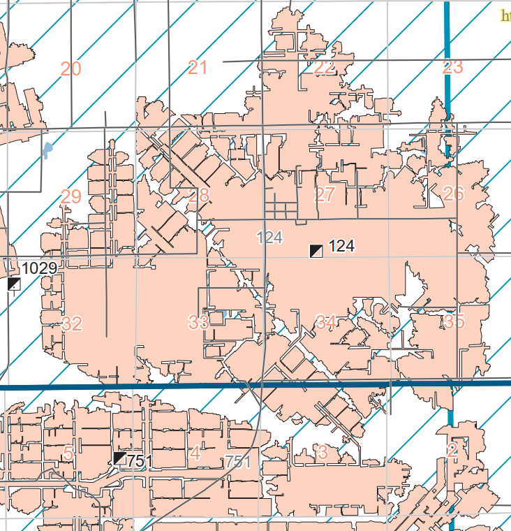 |
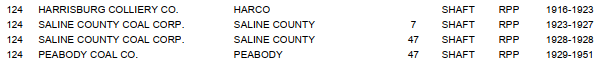
| Dennis DeBruler commented on Raymond's post It was index 124. Springfield Coal Bed Map |
 |
| Dennis DeBruler commented on Raymond's post The town of Harco didn't exist in 1938. 1938 Galatia Quadrangle @ 1:24,000 Raymond Barr: I am sorry Dennis, but the unincorporated village of Harco was plotted in 1919...and had a post office since 1917. The map you have here shows "Town Hall" in the center. Well, that's Harco. Since Harco was unincorporated and a company town, the cartographer may not have had access to its name. Google and Wikipedia give a full accounting of the physical life of Harco IL. [See the reply to this comment at the bottom.] |
 |
| Dennis DeBruler commented on Raymond's post But it was founded by 1963. 1963 Galatia Quadrangle @ 1:24,000 |
 |
| Dennis DeBruler commented on Raymond's post The Big Four's Little Egypt line beat out the Illinois Central for coal mines in this area. 1949 Puducah Quadrangle @ 1:250,000 |
 |
| Dennis DeBruler commented on Raymond's comment Harco was located North and West of the mine's tipple. On the 1938 map, that would be the "ur" of the Brushy Church label, not at Town Hall. This 1938 aerial photo shows that the town was bigger than it is today. Omitting a town is the type of error I don't normally encounter on topo maps. The 1963 map has the town and church labeled correctly. Brushy Cemetery still exists: https://www.google.com/.../data=!3m1!1e3!4m5!3m4... |
Dennis DeBruler commented on Raymond's post: While researching the labeling error on the 1938 topo map, I found this resource: https://hinton-gen.com/coal/saline_harco.html.
 |
| Roger Kujawa posted There are quite a few pictures on eBay saying they are in Harrisburg, Illinois. I’m not sure. Here is one. https://ebay.us/m/ricc0q |
.jpg) |
| Dennis DeBruler commented on Roger's post The only big Peabody mine in Saline county in 1949 was #47 near Harco, IL. The photo is consistent with a 1938 aerial photo. It was served by NYC/Big Four. Aerial photo source: https://towns-and-nature.blogspot.com/.../saline-c-harco... |
Before it occurred to me to search for Harco, I found these additional references.
 |
| isgs |
 |
| Apr 4, 1959 @ 17,000; AR1VXO000010074 |
No comments:
Post a Comment