Monday, November 13, 2017

Pitken, CO: Denver, South Park & Pacific Depot

(Satellite)
See Como, CO, roundhouse for an explanation of why I recognize what DSP&P means.

Mark Mitscher posted
Pitken, Colorado on the DSP&P RR.
The eaves are so large that they cover the bay window and wooden platforms so it looks like yet another rectangle in the satellite image. But the buildings in the background with gables going in two different directions allowed me to finally locate where I think this is --- the north quadrant of State and 6th. The placement of the chimney on the satellite rectangle is also consistent with the photo.

Satellite
These "land scars" indicate the track used to run through town on the north side of State Street. So the track used to be between this building and State Street.

I was pleasantly surprised that the town looks rather prosperous for a town in the Colorado mountains. Did it exist because the DSP&P needed a water tower here or because there was some mining in the area or both? Does mining still exist? Unlike the old towns along I-70, I doubt if there is enough tourist traffic through this town to keep it alive.

Cairo, IL: IC Interlocking Towers: Davis: IC vs. GM&O and Bridge

Bridge: (Satellite, now just a signaling equipment cabinet.)
Junction: (Satellite, the replacement tower. Again, it is marked by a signaling cabinet.)

While researching the location of the Cairo Junction, I found this picture of the Illinois Tower in the bridge posting. Note that Mobile & Ohio trains must have used the Cairo Junction to join the IC mainline to share this expensive bridge. A 1946 GM&O train is consistent with the 1940 merger of M&O with Gulf Mobile & Northern. And 1946 is long before GM&O became a fallen flag in 1972 when the ICG was created by merging both of these north/south routes --- IC and GM&O.

Photo 14 from Classic Trains, Henry J. McCord
New Orleans–St. Louis Rebel motor train at North Cairo, Ill., July 1946.
[Comments on a posting disagreed with "North Cairo." It was Illinois.]
Paul Turner It sits (or did sit) right above the Cairo Water Treatment plant, now Illinois American. Looking down on Bunge and the former Burkhart plant.
Paul Turner Those folks at Classic Trains are great, and I’m a subscriber, but that’s not North Cairo. In RR timetable parlance, that’s, as the shanty indicates, Illinois. But that is Cairo, geographically in the general sense. I’ve climbed those stairs, there are 99 of them, as we counted them in High School.

1938 Aerial Photo from ILHAP
The Bunge plant was rather small back then. The track going south from the top of the image to under the bridge and then curving west was the Big Four.

Andrew Waldo posted
Cairo, Illinois: Interlocker Tower, Mobile & Ohio Railroad/St. Louis, Iron Mountain & Southern Railway. This Interlocker Tower was located at Levee Junction near Cairo, built only two years earlier. It was photographed on 1 May 1916.
Credit: National Archives & Records Administration, ICC Engineering Field Notes, Mobile & Ohio Railroad, Illinois. Digital Image Collection of Andrew Waldo.
[Note the signalling pipelines on both sides of the track.]

Andrew Waldo posted
Davis, Illinois: Interlocker Tower, Mobile & Ohio Railroad. This Interlocker Tower was located at Davis, near Cairo. It was estimated built in 1900 and was photographed on 23 May 1916.
Credit: National Archives & Records Administration, ICC Engineering Field Notes, Mobile & Ohio Railroad, Illinois. Digital Image Collection of Andrew Waldo.

Illinois Central Railroad Scrapbook posted two photos with the comment:
Two views of the interlocking tower at Cairo Junction, Illinois.  Located about 3 miles north of downtown Cairo, the tower protected the junction between Illinois Central's north-south mainline and Mobile & Ohio Railroad's line from St. Louis  (the M&O had trackage rights across IC's Ohio River bridge; on the south side of the river, the M&O joined the IC at Winford Junction, KY).
Cairo Junction also was the location where IC's line into the city of Cairo itself joined the mainline.  
The tower seen here was built in 1902.  According to an article in the June 6, 1902 "Railway Age", the tower controlled 15 turnouts (a.k.a. "track switches"), 14 signals, and 1 movable point frog.  This was an electric interlocking plant.  In other words, when an operator turned a lever, a signal was sent to an electrical motor connected to the turnout or signal, causing that device to move.
The signal equipment was supplied by Taylor Signal Company.  Apparently IC was not happy with this equipment.  The December 24, 1909 issue of Railway Age Gazette says the old equipment was replaced by new signal equipment supplied by General Railway Supply.  The old building was kept, however.  
The tower had a short life.  Disastrous floods hit the Mississippi River in 1912, and the Ohio River in 1913.  The city of Cairo itself was spared thanks to several miles of levees and a downtown floodwall.  But IC's track north of town was heavily damaged.  In response, several miles of track were raised between Cairo and Villa Ridge.  The tracks at Cairo Junction were raised about 5 feet, necessitating the construction of a new interlocking tower.
Both photos, IC photographer, Cliff Downey coll.
 Cliff Downey shared
1

2

EarthExplorer: Feb 21, 1952 @ 23,600; AR1SW0000010137
Dennis DeBruler commented on Cliff's share
It appears that the replacement tower was in the middle of the curve of the connector.


Cairo, IL: Cairo Junction (North Cairo): IC wye to M&O wye

(Satellite, based on the aerial photo below.)

Some Facebook comments refer to "North Cairo," but the 2005 SPV Map and other comments disagree with "North Cairo." The junction is at the wye of a short connector to another wye at the CN/IC/ICG/GM&O/Mobile & Ohio. Evidently the IC tower controlled the turnouts of the M&O wye as well.

Chris Johnson posted
North Cairo IL depot interior, 11/30/36.
Larry Candilas: Would this be what is officially called Cairo Junction?
Chris Johnson: Larry Candilas Probably so

Mike Sypult posted
North Cairo, Illinois on the IC. Clyde L. Anderson photo. Undated.

Illinois Central Railroad Scrapbook And Occasionally Other Railroads posted two photos with the comment:
Two views of the interlocking tower at Cairo Junction, Illinois.  Located about 3 miles north of downtown Cairo, the tower protected the junction between Illinois Central's north-south mainline and Mobile & Ohio Railroad's line from St. Louis  (the M&O had trackage rights across IC's Ohio River bridge; on the south side of the river, the M&O joined the IC at Winford Junction, KY).
Cairo Junction also was the location where IC's line into the city of Cairo itself joined the mainline.
The tower seen here was built in 1902.  According to an article in the June 6, 1902 "Railway Age", the tower controlled 15 turnouts (a.k.a. "track switches"), 14 signals, and 1 movable point frog.  This was an electric interlocking plant.  In other words, when an operator turned a lever, a signal was sent to an electrical motor connected to the turnout or signal, causing that device to move.
The signal equipment was supplied by Taylor Signal Company.
  Apparently IC was not happy with this equipment.  The December 24, 1909 issue of Railway Age Gazette says the old equipment was replaced by new signal equipment supplied by General Railway Supply.  The old building was kept, however.
The tower had a short life.  Disastrous floods hit the Mississippi River in 1912, and the Ohio River in 1913.  The city of Cairo itself was spared thanks to several miles of levees and a downtown floodwall.  But IC's track north of town was heavily damaged.  In response, several miles of track were raised between Cairo and Villa Ridge.  The tracks at Cairo Junction were raised about 5 feet, necessitating the construction of a new interlocking tower.
Both photos, IC photographer, Cliff Downey coll.
Shapley Hunter IV: The line from St. Louis was originally built in 1875 by the Cairo & St. Louis Railroad which, despite the name, never made it all the way to Cairo because they could not get right-of-way permission to cross Washington Street (despite the street not actually existing except on paper at the time). They had to negotiate an agreement with Illinois Central to use IC's tracks to enter the city itself. It also did not make it all the way to St. Louis, but stopped in Illinois. Originally a narrow-gauge railroad, the gauge was broadened after it was acquired by the Mobile & Ohio Railroad in 1886.
The Cairo & St. Louis Railroad initially stopped in Union County, as Alexander County and the City of Jonesboro were unwilling to allocate funds for the project through their jurisdictions.
The line nearly went bankrupt in 1877 when the Kaolin Tunnel, near the community of Kaolin, in Union County, collapsed. The Railroad reorganized as the St. Louis & Cairo Railroad in 1881. Kaolin was a mining town in which Kaolin, or China Clay, was mined and shipped to St. Louis.
Richard Fiedler shared
1

2
Jon Roma: There's a lot going on in this photo. From left to right:
The stove door is wide open, and there are a couple lumps of coal on the tower's floor.
The interlocking machine lacks a cover.
Above the window at left is the model board; unfortunately, the track layout isn't visible.
I see the ammeter and voltmeter to the right and below the model board on the left wall.
At right background, I see someone's lunch basket.
There's a CB&Q calendar on the right wall, and below it is a salt shaker.
At near right, I see the three handles used to operate the three train order signals depicted in the exterior scene.
There are three telegraph keys and a couple of sounders on the desk at right, but I don't see where they're wired in.
There's more telegraph equipment on the leverman's desk.
The blurred person who sits front and center is left-handed but doesn't look old enough to work for the railroad, though I could be wrong.
Though I have seen this image before, it's one I never grow tired of.

Stephen N. Brannon posted
North Cairo, Illinois Tower. Junction of IC north-south main with GM&O St. Louis-Mobile main. Photo looks northward, IC on the right and GM&O branching off to the left. GM&O used IC bridge across Ohio River to Kentucky, then with joint double track a few miles south to Winford Jct. where GM&O split off on its own rails.

Tommy Sowell posted
Dad doing his thang.
This was one of the motors ,that ended up being used for some merger advertisement pics.
Jimmy Smallwood I remember one day we were standing out in front of the callers office and you dad had his grip setting on the ground there and Glen McCullar came up in his vehicle and ran over it.
John P. Kohlberg posted a copy of Clyde's photo above pointing out that the rip-rap cars above look similar to the rip-rap cars in the background to the left of the Cairo Tower.
John P. Kohilbert commented on Tommy's posting.
[Note the GM&O marking. They had some yard tracks along the river back then. I wonder if these cars are kept here on standby in case they need to do any emergency repairs of a washout somewhere in Southern Illinois.]
It looks like the tower also controlled the entrance to a small yard inside the wye along the IC mainline. This connection between the M&O and the IC would have been used by all through M&O trains because they used the IC bridge over the Ohio River.
1938 Aerial Photo from ILHAP

The GM&O is down to just one track along the river and it looks like it is used for storage.
Satellite
Satellite
CN must use the M&O tracks into Cairo for storage because the satellite image caught them with a lot of covered hoppers on the track even though its route to Bunge is now broken. But since both the M&O and the IC routes are now owned by CN, they could easily pull that string north and then shove it over the wyes to the former IC track that still serves the Bunge plant.

Saturday, November 11, 2017

Charleston, SC: Camden Depot and Union Station

Camden North: (Satellite)
Camden South: (Satellite)
Union Station: (Satellite, northwest quadrant of Columbus and Bay Streets. In 1966, this land became part of the S.C. Ports Authority. [PostAndCourier])

The significance of the Camden Depot is that it is where 141 paying passengers boarded the first commercial train to run in America on December 25, 1830. It ran on the South Carolina Canal and Rail Road pulled by the American made Best Friend Of Charleston locomotive.

I discovered that The Charleston Museum has slapped a Copyright on photos that are in the public domain. Since they are not "playing nice," I'm not including a link to the museum because I don't want to give them "click traffic." I got these photos from the Library of Congress.

Photo from HABS SC,10-CHAR,330A--1 from sc0394
EXTERIOR, NORTH END AND WEST SIDE
Photo from HABS SC,10-CHAR,330A--2 from sc0394
GENERAL VIEW, NORTH (left) AND WEST SIDES
Photo from HABS SC,10-CHAR,330A--3 from sc0394
NORTH SIDE, LOOKING SOUTHWEST 
Photo from HABS SC,10-CHAR,330A--4 from sc0394
NORTHEAST ENTRY PIER, FROM NORTHWEST

Fortunately, the buildings have been repaired and repurposed
1977  South Carolina Department of Archives and History
2007  South Carolina Department of Archives and History

Street View

BestFriendOfCharleston
In addition to housing the Children's Museum of the Lowcountry, it houses the Best Friend of Charleston Museum. After Norfolk Southern restored a replica of the locomotive and displayed it in its headquarters for six years, the replica is now on display along the windows of the museum so that you can see it even if the museum is closed.
.

Union Station

 
safe_image for Do You Know Your Lowcountry? Charleston’s Union Station

1919 Charleston Quad @ 21,120

Wednesday, November 8, 2017

Davenport, IA: Rock Island Roundhouse

3D Satellite
Andy Wellman shared
An aerial view of the Nahant roundhouse in west Davenport. At one time, there were about 6 of these in the Quad City area. This one and a trace of another exists in Moline.
J Pete Hedgpeth This RH is former Milwaukee. RI and MILW joint track from West Dav. to Culver Tower at Muscatine.
Morgan Bush The Roundhouse is still there. It was the home base of the Iowa Chicago and Eastern. Now it's Canadian Pacific.
John Mennenga I live in the quad cities now and am fascinated by the Milwaukee road what presence did they have here?
Ray Peacock You're looking at it, Nahant Yd. (but not the mains at the top of the pic, this was RI trackage starting at West Dav). MILW was half owner of the Dri-Line (Union Station Dav) running to Clinton, with the CB&Q. Crescent Bridge was DRi Line too, meaning Milwaukee had access to the Rock Island side and upriver at one time all the way to Savanna IL via E Moline and Port Byron!

MILW ran on trackage rights from the Rock Island west of West Davenport to Muscatine (Culver Tower). At one time they ran to Eldridge and beyond on a branch.which CP uses to Eldridge. BTW, CP shut down the roundhouse last year for locomotive servicing. The fuel racks are still there but not nearly as much power is seen as in this pic as during the DME era or assimilation of it by CP as seen here. The DRi line was dissolved in 1995 today owned by CP and BNSF.
Ray Peacock The way it was in the 60s/70s.http://godfatherrails.com/photos/pbl.asp...    Here is a more recent Davenport environs collection from the Soo->IMRL->DME->CP era. http://heartlandrails.com/photos/pbl.asp...

Tuesday, November 7, 2017

Cresson, PA: (MO) Tower: Pennsy over NS/Pennsy, Railpark and "Feed Mill"

Tower: (Satellite, it was in the northeast quadrant of the mainline and flyover.)
Railpark: (Satellite)
"Feed Mill:" (Satellite)

Mark Hinsdale posted
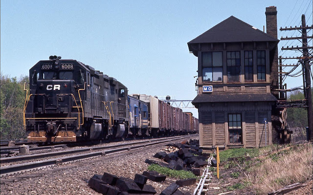
Over & Under at "MO"
When the secondary trackage to the west of Cresson PA still connected to the eastbound side of the ex PRR main line via the flyover. The entire plant was under the control of the operator at "MO." The bridge and tower are long gone, today.
Dale V Rockwell: Cresson is still cool, but not even close to THIS cool!! Model board for MO now resides at The Station Inn.
Mark Hinsdale posted again
Today [Apr 1, 2024,] marks the 48th anniversary of the creation of Consolidated Rail Corporation, or, Conrail, as it came to be known.  The U.S. railroad map, and indeed, the entire industry, would be forever changed, for better or worse.  Here is a view of "Big Blue" I captured in August, 1994, at Cresson, Pennsylvania, on the ex Pennsylvania Railroad's main line across the Allegheny Mountains.  Photo by Mark Hinsdale
John Eagan: I never was able to get an angle like that! All of mine were west of the flyover so MO was barely visible. Kudos on a great shot Mark!
Mark Hinsdale: Kind thanks, John. Almost an over/under but that eastbound was struggling uphill a bit too much to make it in time.
[Gallitzin Tunnel is just a little east of here, so this town is just a little west of the summit.]
Mark Hinsdale shared
Robert Singer: I got paid to watch the trains go by! I had a window seat at Alto, MG, AR, Mo, So, and C!
Mark Hinsdale: Robert Singer, I did too! Started as an operator on the C&O in Detroit in 1971. I suspect your views at the towers you mentioned were better than mine, though! 😆

Craig Hensley Photography posted
A set of patched Conrail helpers shove on the back of an eastbound freight passing MO Tower in May of 1977. Emery Gulash Photo.

The secondary branch still connects, but with a wye and crossovers. We can tell where the flyover was from the treelines.
Satellite plus Paint

safe_image for Conrail’s Cresson – Summit of the Alleghenies
"A pair of SD40-2 helpers shove eastbound PIAL-3 over the mountain on October 24, 1994. Most of this Conway-to-Allentown freight is now moving downgrade, with the summit of the Alleghenies just east of this location."
"Three mainline tracks of Conrail’s Pittsburgh Line, with PRR position light signals mounted to a railroad overpass.  MO Tower’s operator could be heard barking out orders to mainline helper sets of SD45-2s to tie on or cut off, fuel and sand at the pit, and so on.  Two coal branches radiate out from the area; Conrail’s Irvona Secondary to the northeast and the Cresson Secondary which connected a network of former PRR and NYC branches as well as Bethlehem Steel road Cambria & Indiana."
The flyover was removed in 1995 to make room for doublestack container trains.
[Two of the photos are of a 15 locomotive consist that arrived and shoved into the engine terminal.]

Viral Media posted
On one of the longest days of summer, Penn Central train No. 33, the westbound Juniata, drops down into Cresson, PA, after cresting the Alleghenies behind the usual ex-PRR E8. This New York-Pittsburgh day train was basically an ancestor of Amtrak's Pennsylvanian. The following day the troubled Penn Central would declare bankruptcy. June 20th, 1970.
Photo Credit to Tom Nelligan.

Cresson was a hub for Pennsy.
1954 Ebensburg Quad @ 62,500

1989 Cresson Quad @ 24,000

Fortunately, John's comment indicates the tower was north (timecard east) of the flyover. Otherwise, I would have concluded it was in the southeast quadrant.
Apr 4, 1958 @ 28,000; AR1VTC000010030

Since Mark's photo shows that it was still standing in 1994, I checked out a more recent aerial. It still looks like it is on the south side instead of the north side. I'm surprised that the aerials are so deceiving.
May 12, 1972 @ 24,000; AR1VCYN00020174

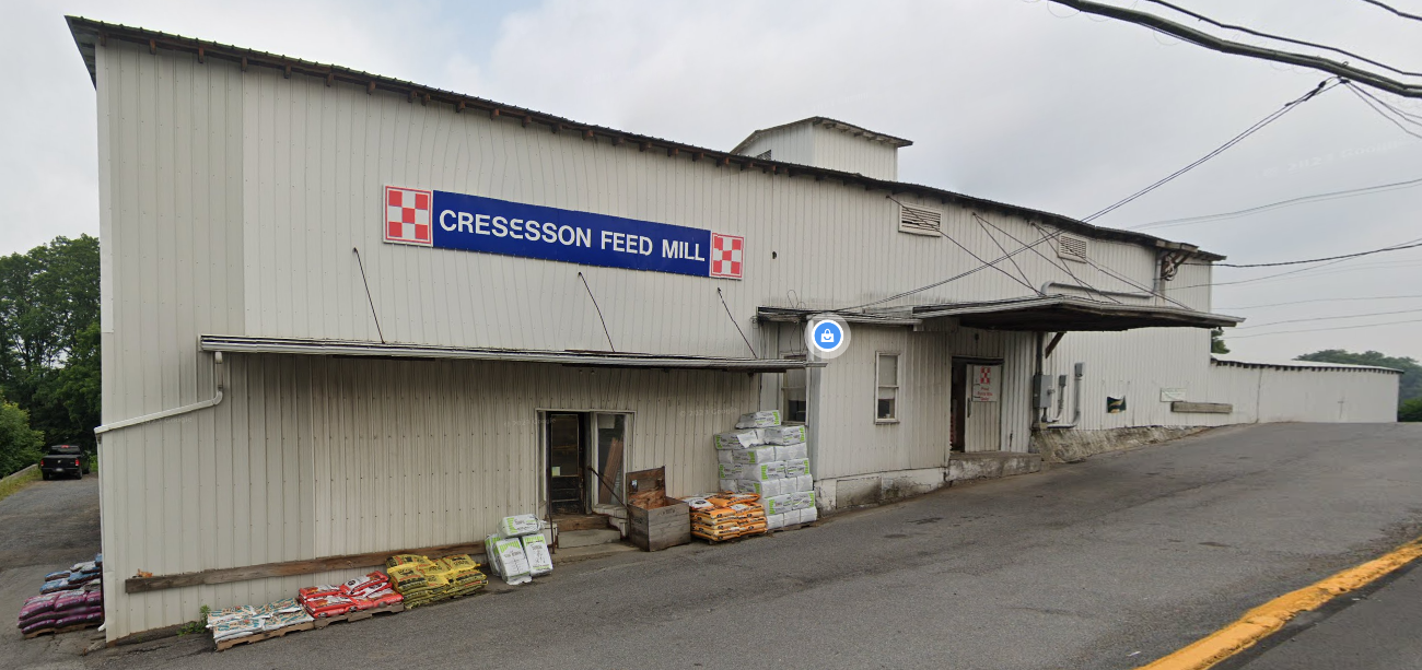
Judging by the 207 photos on Google Maps, the "feed mill" is now a pet, garden and hardware store.
Street View, Jul 2023

In addition to a viewing platform, the railpark has a caboose.
Yetemar-Kenyell Cross, Oct 2022

StormySky Rail Productions posted
Pennsylvania Railroad caboose at the railfan park in Cresson, PA.  Photo taken in 2022.

Some of the 269 photos on Google Maps indicate that there is a fueling facility inside the wye. And this satellite image shows that the railyard on the west side of town is still used. I presume that locomotives are refueled out in the middle of nowhere because helpers are still used to get trains up the sides of the mountain.
Satellite

Monday, November 6, 2017

New York, NY: Jay Interlocking: Long Island Rail Road and Richmond Hill Roundhouse

Tower: (3D Satellite)
Roundhouse: (Satellite)

Mark Hinsdale posted
A rare, quiet moment at "Jay" interlocking, looking west from the platform at MTA Long Island Rail Road's Jamaica (Queens) NY station. May, 2008
It sounds like LIRR did a lot of work on these turnouts about the time Mark took the photo.

Designing the new configuration

Roundhouse


Mike Pedian posted
David Clapper Sr.: What are the 2 white buildings?
Mike Pedian: David Clapper Sr. One right behind round house is the new back shop and the other is the Richmond Hill car shop and Back shop that was built when they shut down the original Back shop till 20 years later they built a permanent replacement.
.

Snow (Tracks on Fire)


Ricky Kaufman posted four photos with the comment:
It’s cold, which means it’s time to set the switches on fire to keep one of the USA’s busiest interlockings running, with bonus M7 trains in the background. 
Taken this morning (2/17/24) at Jay Interlocking in Jamaica, NY, USA.
Dennis DeBruler shared
1

2

3

4