 |
| Wayne Koch posted NYC-InterstateExpress_OakdaleTower,Toledo,Ohio,May1953 NYCHS. James Tanner The water tower in the background still stands today. Dennis DeBruler Please provide the street names for a nearby intersection. I can't find Oakdale on my 2005 SPV Map. Ray Bottles Oakdale was a interlocking Tower on the New York Central NOW CP 286 Two miles East of Toledo Ohio CUT Depot that CP288 !! Take it from someone that's been around over 50 years as a Conductor and prior to that a Railroad Fan 70 years!! You won't find that on a MAP!!! |
The discrepancies between the 2005 SPV Map and a current satellite image are interesting. I wonder how much these differences were changes in a little over 10 years and how much these differences were errors in the map. The map shows that B&O used to go straight through and cross the NYC. And that the connection in the northwest (west) quadrant existed. But it shows the B&O was abandoned from that connection all the way to the NS/WLE tracks by the oil refinery. As we can see, the track still exists northeast of the crossing. In fact, the orange connection has been added. The names for the two connectors to the NYC are the names on the SPV Map.
 |
| Satellite plus Paint |
The transloading yard down by Oakdale Avenue is new. We can still see the overpass bridges for where the B&O route used to go under them.
I assume this is the water tower that James mentioned. Obviously, the water tower has been upgraded. I guess the road in the photo is Fasset Street and we are looking southeastish. The following topo map confirms that there used to be a lot more tracks through here.
 |
| 1952 Toledo and 1951 Rossford Quadrangles @ 1:24,000 |
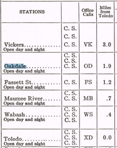
Even though I still can't completely reconcile the photo with the location, the following excerpt from a 1953 employee timetable confirms that the current CP286 used to be Oakdale.
 |
| CanadaSouthern, p10 |
No comments:
Post a Comment