NorthAmericanInterlockings: photo photo (These are the ones below that were posted by William.)
The 2005 SPV Map needs a larger scale for Peoria. My best guess is that the junction controlled the crossing of a couple of terminal railroads in the Peoria area. (2024 Update: I did get the Illinois Atlas that JohnP recommended in a comment below. The CB&Q crossed the PTC (Peoria Traction Company) here and the TP&W switched from using trackage rights on the CB&Q to using the PTC. In fact, David's photo below shows a train changing from CB&Q to PTC tracks.)
William Shapotkin posted two photos with the comment:
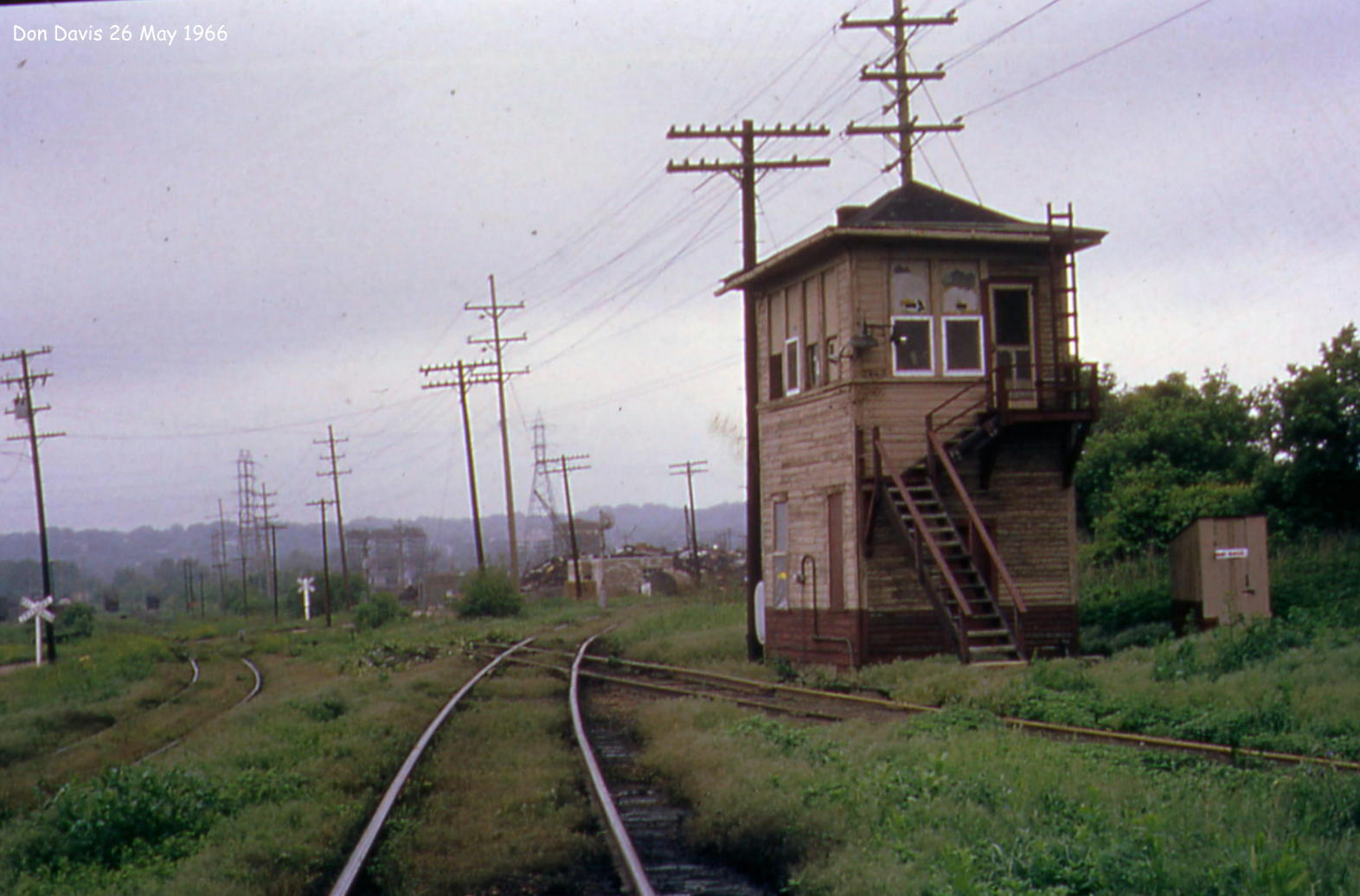
Although not in the Chicago area, here are two pix of Iowa Jct -- located in Peoria, IL. Visited this spot about three years ago with a couple of friends and while some tracks are in-place (and trains do operate here), you would never know it was the same location. Both pix by the late Don Davis -- to whom we owe a debt of gratitude for taking these pix.
 |
| 1 |
 |
| 2 |
 |
| John Stell posted Peoria Terminal Railwa y tower on west side of Peoria at CB&Q Crossing. PT crossed CB&Q at this tower. TP&W ran on CB&Q then entered around 500 feet of their own and then go on to PT to run to Hollis. PT then ran from Hollis to Pekin. Monty Powell slide 5-2-1959 John Stell collection. |
 |
| David Jordan updated Jack Fuller Iowa Jct.? David JordanDavid and 4 others manage the membership and moderators, settings and posts for Peoria Illinois Railroads Trains & Shortlines.Yes |
Note the Katy boxcar to the right of the tower. That would be at the C&NW railyard that UP still uses today.
 |
| John Stell posted PT tower at CB&Q crossing in Peoria. Monty Powell slide on 5-2-59. John Stell collection. [I could not find "PT" in any of my sources. But the curve in the tracks and the Adams Street Bridge in the left background make me confident that this is the "DI" junction.] Roger Kujawa: The TPW had an interesting route through Peoria. They started in their yard in East Peoria and ran on double track although in Yard limits to the bridge. They crossed the river on a single track bridge, crossed the Rock Island at Walnut Street and entered Burlington track. They ran the Burlington track to PT tower. At PT tower they jumped off the Q, ran a couple hundred feet on TPW rails then onto the Peoria Terminal to Sommer where they got on TPW track. Imagine the coordination between all the railroads, yardmasters, bridge tender, the train crews to move this train before radios. The TPW also had to contend with Burlington passenger trains between PT tower and the Burlington Depot at one time. There were train orders for TPW track, Burlington Track and PT track. John Stell posted East side of Peoria Terminal Tower at CB&Q Crossing. Monty Powell slide dated May 2, 1959 [After my comments below] David Jordan: Ft. of W. Clarke St. You can see the old S. Adams St. viaduct in the distance at left. David Jordan Clarke Street Tower was located in this general area, just north of W. Clarke Street. Dennis DeBruler: Thanks much. I'll go back and reread all of the comments and study the map some more now that I have a better idea of where the tower was. I assume that this is what John has been calling "PT Tower" in some of his other posts of a train passing the tower. David Jordan: Dennis DeBruler I believe PT tower, Clarke Street Tower and DI Tower are names of this facility. Dennis DeBruler shared Howard Keil: Adams street Viaduct in the background? Dennis DeBruler: Howard Keil Yes, https://towns-and-nature.blogspot.com/2020/09/peoria-il-iowa-junction.html |
 |
| Dennis DeBruler commented on John's second post To try to find the location of this tower, I checked the 1906 Railway Guide, https://books.google.com/books?id=kLgbTCc-AOcC&pg=PR9.... It paid off. |
 |
| Dennis DeBruler commented on John's second post This timetable info is information overload for me, but I thought it might be of interest to others. Note, this is the Freight Service Edition. |
 |
| Dennis DeBruler commented on John's second post And I zoomed in on the insert. |
 |
| Richard Fiedler posted Paul Grone: "Day man had an 1898 seniority date." 🤣🤣 At least 80 in 1959?🤔 John Stell: Paul Grone He had a new Mercury convertible and did not want to retire account did not get along with girl friends family. Craig Cloud: Did Peoria Terminal employees have separate union agreement from parent Rock Island? John Stell: Craig Cloud All were RI except for operators and train directors were PT only. |
The curved tracks from top to bottom were C&NW, CB&Q and Minneapolis & St. Louis (M&StL). The M&StL is now abandoned.
.png) |
| 1939 Aerial Photo from ILHAP |
You really need to get yourself a set of these Atlases:
ReplyDelete"A Railroad Atlas of the United States in 1946" by Richard C Carpenter.
Vol 4 is Illinois. The are 4 Peoria maps (overview, detail, and close detail of downtown Peoria and Iowa Jct"
https://www.amazon.com/Railroad-Atlas-United-States-1946/dp/1421401460
It looks like in '46 there was a tower where the CB&Q crossed the PTC (with the TP&W having trackage rights on PTC). It also looks like about a quarter mile (or less) beyond was another crossing - without a tower (Stop sign only) - where the PTC/TP&W ran in parallel with the P&PU and crossed where the M&StL and CRI&P met each other (in the crossing, so to speak).