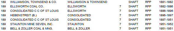
#7: (Satellite) #7 is after #14 because I came across photos for it later.
#14: (Satellite, it was south of Soccer Road just before it turns north)Depot: (Satellite, the land is now a parking lot.)
I didn't notice on the above topo map that the ITS did not follow the Wabash tracks through town. Instead, it did street running on Main and Union Streets so that the depot could be closer to downtown. It was typical for interbans to use a town's streetcar system.
US-66 Overview
 |
| Roger Kujawa posted No. 14 Coal Mine, Staunton, Illinois, Vintage Postcard |
 |
| Dennis DeBruler commented on Roger's post The mine was south of Soccer Road just before it turns north. https://clearinghouse.isgs.illinois.edu/webdocs/ilhap/county/data/macoupin/flight10/00ck01035.jpg |
 |
| Dennis DeBruler commented on Roger's post This shows that the Wabash spur used to go all the way to the mine. Mine #4 should have been labelled #14. 1915 Gillespie Quad @ 62,500 |
 |
| Dennis DeBruler commented on Roger's post This is one of two sources that indicate that #4 should have been #14. The rectangle is the mine's shaft. The circle is an air shaft. https://wikiimage.isgs.illinois.edu/ilmines/webfiles/topo-mines/gillespie-south.pdf |
 |
| https://wikiimage.isgs.illinois.edu/ilmines/webfiles/topo-mines/gillespie-south.pdf |
Mine #7
Jim Yasinski posted three photos with the comment: "Staunton, Illinois Coal Mines."
 |
| 1 |
 |
| 2 |
 |
| 3 |
 |
| Directory |
The coal mine was between the NS/Wabash and Aban/C&NW/Litchfield & Madison railroads. But it looks like it was served only by the Wabash. Most of these roads in 1939 are now gone. Specifically, Route 66 now uses the abandoned L&M right of way. And today's Kenworth Lane used to go further West along the south side of the mine.
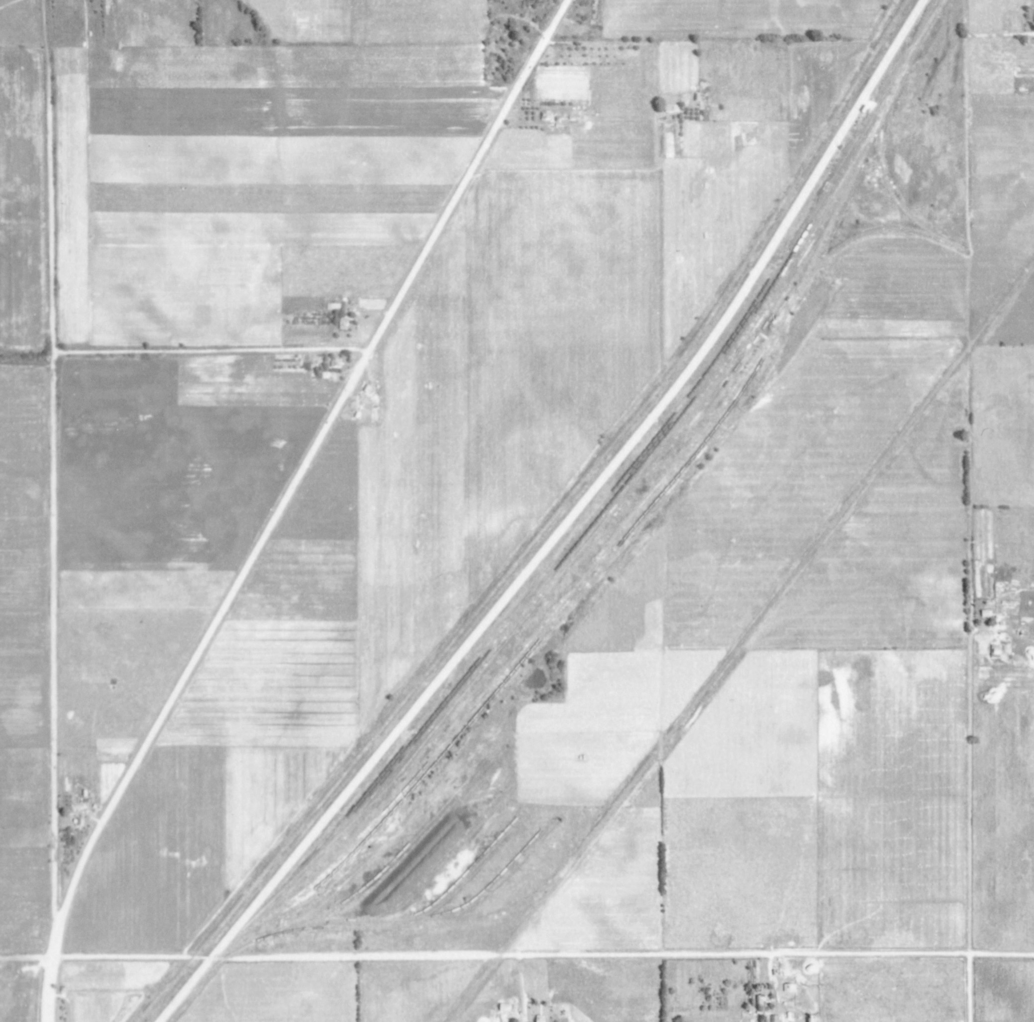 |
| 1939 Aerial Photo from ILHAP |
Illinois Traction System (ITS) Depot
 |
| Andy Zukowski posted Illinois Traction System in Staunton Illinois 1909 The Illinois Traction System (ITS) operated a prominent electric interurban railway connecting St. Louis and Peoria. In Staunton, Illinois, the system was built and managed by electric utility pioneer William B. McKinley. McKinley incorporated the St. Louis & Springfield Railway to build the line extending into Staunton in 1903, which grew into a massive network. |
I didn't notice on the above topo map that the ITS did not follow the Wabash tracks through town. Instead, it did street running on Main and Union Streets so that the depot could be closer to downtown. It was typical for interbans to use a town's streetcar system.
 |
| Tim Howard commented on Andy's post |
No comments:
Post a Comment