Swing Bridge: (Satellite)
In the original spirit of this blog that it would include travelogs and nature, this is a field trip to check out what the DuPage River looks like after the Hammel Dam was removed and to check out the size of the coal pile at the Will County Power Plant. Since the parking lot for the power plant is also close to the swing bridge, I checked it out again.
The first part of the trip that checked out the river after the dam was removed is here. But I copied the photo that taught me that some ducks stay in Chicagoland during the Winter. In addition to these four ducks on a side creek, I saw some floating down the middle of the river.
 |
| Dennis DeBruler |
On the way between the dam and the power station, I learned that there still are some farm fields along Weber Road.
 |
| 20230210 2221c |
Not only does a homestead have grain elevators, it has a round barn.
 |
| 3D Satellite |
Although I'll bet that barn now contains people instead of farm animals. Note what looks like a red chapel on the right.
 |
| Street View, Sep 2019 |
But their big event space is on the back forty.
 |
| 3D Satellite |
After I parked in the parking lot for the Centennial Trail, I turned north and took a photo of one of my favorite bridges. More photos of this bridge later. I first headed south to cross 135th Street to get another set of photos of the coal pile. (It is always rather exciting to cross this road. I do cross at a marked trail crossing.)
 |
| 20230210 2222 |
I had expected the coal pile to be empty because I read a while ago that this plant would quit burning coal. I've read that several times over the years, but I think it was finally true. But they evidently stopped burning before they got rid of their coal pile. It is smaller than I have ever seen it, but there still is a pile. The two smokestacks happened to line up in this view. There used to be four stacks, but there are now just two. This is the best view I have so far of the plant because during past visits it would be hidden by a much higher coal pile. Sometimes everything inside the dike was full of coal.
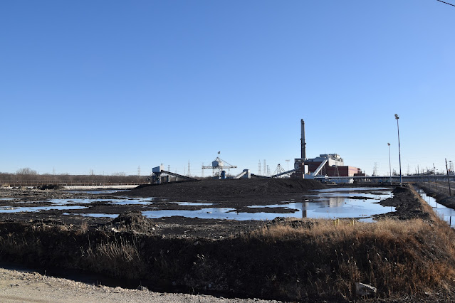
A closeup of one of their old barge unloaders. Before ComEd switched to burning low-sulfur coal from the Powder River Basin, ComEd used to load barges in Havana, IL, and ship the coal up the Illinois Waterway to their Chicagoland power plants.

Taking another shot as I walk east along the road.

The gizmo in the background below is the other old barge unloader on this site. I think the gizmo on the left is a barge loader. I thought it was new, but I looked at a Jun 2012 street view from the bridge, and it has been there. I just couldn't see it before because it was hidden by the coal pile. (There are street views from 2008 and 2009, but they are not near as good as the ones we started getting in 2012.)

There is a BNSF/Santa Fe road crossing nearby that is not in a quiet zone. So the horn on this locomotive let me know that a train was coming. It had just two locomotives because the whole train was nothing but empty platforms. The time stamp on this photo was 3:21pm.

While killing time as the train rolled by, I worked my way as far east as I could go on the road before I ran out of a raised shoulder to stand on.

Finally, the end of the train appeared at 3:24pm.


 |
| 2229, cropped |
Back across the road near the parking lot, I take a photo to the East. This is the section of the Chicago Sanitary and Ship Canal that is electrified by the US Army Corps of Engineers to create a barrier against invasive species. They are trying to keep unwanted species in the Great Lakes from getting in the Mississippi basin and vice versa. The motivating species was invasive (Asian) carp.

I decided to take some more closeup photos of the bridge since I was so close to it. I don't remember taking a photo of this plaque before, but I did. So this photo is essentially a throwaway. That is good, because it looks like it has bad depth of field. I checked my metadata, and the camera chose f/11 and 1/500 sec. I need to remember that when I'm taking something up close, that f11 is not enough. The next time I visit the bridge, I'll try this photo with the max f-stop as an experiment.

I took this overview of the center tower part so that I could compare the rust with photos that I had taken in March 2020. The covers at the bottom of the four tower columns are new.

Since my new camera has a LCD that I can fold out and tilt, I tried taking a better photo of the drive by holding the camera over the railing. This is the drive on the west side.
And this is the drive on the east side.

I met a couple on the bridge that told me there was a bald eagle on the west side of the trail about 100 yards down the trail. So I headed north on the trail.

I decided to take some more closeup photos of the bridge since I was so close to it. I don't remember taking a photo of this plaque before, but I did. So this photo is essentially a throwaway. That is good, because it looks like it has bad depth of field. I checked my metadata, and the camera chose f/11 and 1/500 sec. I need to remember that when I'm taking something up close, that f11 is not enough. The next time I visit the bridge, I'll try this photo with the max f-stop as an experiment.


I don't remember this sign on the trail. I didn't take a closeup of the sign because it looked like the one that they have up by the Santa Fe Bridge. I was right about it being the same sign. But my memory was wrong because I have taken a photo of this sign.
Remember, we are just a little upstream from the USACE electric barrier.
We were definitely on an embankment. Was the embankment built for the trail to keep it out of flood waters, or was the trail built on a pre-existing embankment? If the embankment already existed, what was it built for? I'm sure the USACE added the concrete barrier on top of the embankment as part of their invasive carp barrier. There is mortar between each barrier segment.

Why would you put a hole in the barrier? I decided that this is a low point, and they put this gate here so that they could drain the remaining water from the trail after the flood waters receded.

These last three photos were an attempt to get a photo of the big bird nest in the trees. I'm glad I took a three photos because the first two ended up being another lesson in how the autofocus works. It keyed off the twigs in the foreground. Bummer. I thought about turning off the autofocus and setting the lens to infinity. Next time I need to do it rather than just think about it. And while I'm going manual, I should set the camera to aperture priority and crank up the f-stop. I don't like setting the camera to manual modes because then I forget to reset them to automatic. These photography mistakes help me appreciate professional photos.


Note the water at the base of the tree that has the nest. It had rained most of the previous day so the rivers in the area were high.


Is this the nest of a bald eagle?
 |
| Digitally Zoomed |
Since the river was high, I grabbed a shot of the west channel north of 135th.

Nice article. Here's a waymark I posted on the bridge some time ago: https://www.waymarking.com/waymarks/wm4GT5_Historic_Romeo_Road_Swing_Bridge_Will_County_IL
ReplyDelete