After the 1982 flood, Fort Wayne created the Headwaters Park on the worse of the flood plain. [HistoryCenterFW1] [HistoryCenterFW2]
(Update: there are plans to build a roundhouse in the Headwaters Park to house the steam locomotive NKP 765.)
News-Sentinel Gallery of eleven photos of the 1982 flood
In 1982 I lived in the Chicago area. But my sister still lived in my home town of Fort Wayne, IN. She was in high school. I remember her telling the story of all the high schools let out their students so that they could help with the sandbagging efforts. Sandbags were filled by volunteers in the Coliseum parking lot. She was part of the crew that helped save Pemberton Dyke. The system of levees and flood plains like the Lakeside Golf Club can handle normal heavy rains. But that year the weather quickly changed from cold to warm. That year also had a significant amount of snow on the ground when the weather became warm. And the warm weather brought rains and stayed above freezing at night. The warm rains quickly melted the snow pack. But the ground was still frozen so all of that melt water and rain overwhelmed the rivers.
News-Sentinel photo gallery of the 1982 flood.
Daniel Hitzeman posted three photos with the comment: "Next month, 36 years ago!"
Stephanie Keller posted eight photos with the comment: "Flood of 1982.. bad pics but was taking them from the newspapers saved by my Mom.❤️ Will post more later but digging into all of this is upsetting as I’ve lost both my mom and dad in the last three years. Good memories and I love Fort Wayne❤️"
Becky Osbun posted five photos with the comment: "On March 17, 1982, Donald L. Weber took many incredible photos. For those of you not familiar with the SW side, the lone bldg. in the middle of a "lake" is the Sports Club on Ardmore Ave. From the Indiana Memory archives at http://contentdm.acpl.lib.in.us/…/r…/collection/coll4/id/343"
Loretta Krumwiede Barlow Getting all the sandbags off Pemberton Street took forever. A classmate of mine lived there, and the whole street sorta became part of the dike, where the kids saved a significant part of the city.
Becky Osbun Wonderful piece written by Kathryn Baker. http://historycenterfw.blogspot.com/.../the-city-that...
Rod Consalvo I worked for GTE our Dispatch Test Center was 3 ft under water had to move them to Berry St over the weekend, remember it well.
Dennis Schebig Fire Chief Tony Myers was ready to blowup the Tennessee bridge because it was holding back water.
Jamie Tomlinson That was an unforgettable time. I lived onSt. Joe Blvd. We moved what we could to the 2nd floor and watched as the water crept higher and higher. Sandbags were in place but it was felt that the dike might not stand so utilities were cut off. Then we moved to my uncle’s place for three days. The dike held and we were able to go back home. Incredible effort by the community to save our neighborhoods.
News-Sentinel Gallery of eleven photos of the 1982 flood
 |
| Photo from a Kenneth Childers' posting of the peninsula that was converted to a park. |
 |
| Photo from Kenneth Childers' posting |
 |
| Randy Harter posted, cropped
League Park – 1924
This article was written for and is courtesy of Fort Wayne Reader newspaper.
This wonderful aerial photograph of League Ball Park was taken by east coast photographer Hamilton Maxwell for the News -Sentinel, and published in their rotogravure section on February 23, 1924.
According to research by Bill Griggs and Jim Nitz for the Society for American Baseball Research, this low lying flood plain called the “thumb” which was created by the St. Mary’s River and is now known as Headwaters Park, was first developed as a baseball venue in the spring of 1883 with a grandstand constructed that would hold 1,500 fans and included room for another 500 standing (center of map - #24). This area is where formerly circuses visiting the city had annually pitched their tents.
The grandstand location was east of Calhoun Street on the “Jailhouse Flats”, the area so named as it was across from the city’s first jail, and where public hangings took place up until the early 1880’s. Through the years, the grandstands were rebuilt and expanded a number of times as the result of the popularity of baseball, condition of the venue, and damage incurred during the 1913 flood during which the entire area was underwater. During the 1920’s the League Park grandstands were rebuilt to hold 5,000 fans. Suspected arson later leveled the structure to the ground in July of 1930 including destroying all equipment and uniforms. Afterwards much smaller grandstands were then constructed holding about 1,500 patrons.
As the New York Central (later Penn Central) ran through Fort Wayne on its way from New York City to Chicago as well as other railroads bisecting the area, Fort Wayne’s large League Ball Park became a common stop off point for major league exhibition games in the 1920’s. The result was that such baseball legends as fence-busters Babe Ruth, Lou Gehrig, and pitcher Cy Young played games against the local teams at League Park.
The 1930’s and the onslaught of nationwide depression saw Fort Wayne sharing the St. Mary’s River thumb with the new National Guard Armory (1930), League Ball Park, and with our own “Hooverville” as hundreds of families lived in shacks and shanties in the undesirable flood-prone area. By the late 1930’s the tide had turned, baseball had left the “flats”, and commercial businesses had taken over.
The numbering on this map was done circa 1924 by Fort Wayne historian Bert J. Griswold who wrote the seminal books on local history , “The Pictorial History of Fort Wayne Indiana” (1917), and Builders Of A Greater Fort Wayne” (posthumously - 1926). This, his hand-annotated map, is in the collection of the Allen County Public Library Genealogy Department and is courtesy of same.
Randy Harter is a local historian, author and the history/architecture guide for Fort Wayne Food Tours.
[It would have been the Pennsylvania Railroad, not the New York Central, that traveled through town between New York City and Chicago. The NYC had a branch that terminated in Fort Wayne north of the river and connected with the NYC mainline in Waterloo, IN.] |
 |
| Great Memories and History of Fort Wayne, Indiana posted 1913 Flood. Looking from the Fort Wayne Saddlery Co., the bottom of the Spy Run Avenue Steve Barry Notice this is Standish photo. Had a studio at Robison Park. Julianna Price My grandmother was 25 at the time living on Riverside Ave. I heard many stories about this flood. One that sticks in my mind is of them getting out in a rowboat floating over the top of Tennessee Ave bridge. Wow! Scary days. [I don't remember that truss bridge, so it was replaced before 1960.] |
1982 Flood of Fort Wayne and Surrounding Towns
In 1982 I lived in the Chicago area. But my sister still lived in my home town of Fort Wayne, IN. She was in high school. I remember her telling the story of all the high schools let out their students so that they could help with the sandbagging efforts. Sandbags were filled by volunteers in the Coliseum parking lot. She was part of the crew that helped save Pemberton Dyke. The system of levees and flood plains like the Lakeside Golf Club can handle normal heavy rains. But that year the weather quickly changed from cold to warm. That year also had a significant amount of snow on the ground when the weather became warm. And the warm weather brought rains and stayed above freezing at night. The warm rains quickly melted the snow pack. But the ground was still frozen so all of that melt water and rain overwhelmed the rivers.
News-Sentinel photo gallery of the 1982 flood.
 |
| Bobbie Lee posted 1982 flood….. looking west around Taylor and Ardmore. (Image credit: ACPL/ Donald Weber) |
 |
| Darrell Parnin posted ▪︎▪︎▪︎▪︎▪︎▪︎▪︎▪︎▪︎▪︎ NEWS-SENTINEL News staff ▪︎▪︎▪︎▪︎▪︎▪︎▪︎▪︎▪︎▪︎▪︎▪︎ ▪︎▪︎▪︎▪︎▪︎▪︎▪︎ Pulitzer Prize Winning Coverage ▪︎▪︎▪︎▪︎▪︎▪︎▪︎▪︎▪︎▪︎▪︎ It's all all hands on deck at NEWS-SENTINEL with day after day of in depth continuous flood coverage. It would earn them the Pulitzer Prize. The highest award in Journalism. (My mon & dad kept a few of the NEWS-SENTINEL stories that covered major events, and stored them in dresser drawer out of sunlight.) Becky Osbun: Print publication was ceased in October of 2017. Carol Ferckel Perkins: I remember those days! My grandparents were on that boat and their house is in the background. My mom and her sisters were waiting on the Main Street bridge for them. Ranelle Melton: I helped move residents from a nursing home that was in danger of the flood waters. Along Spy Run st. [And there are several comments about helping to sandbag.] |
 |
| Great Memories and History of Fort Wayne, Indiana posted 1982 Flood. |
 |
| Joe O'Connor commented on the above posting Kevin S Harris That picture of Reagan was taken near the Sherman St. bridge. The bridge in the background is for the railroad tracks that run along Main St. It's not the Pemberton dyke. |
 |
| Greg Marlow posted Earlier, one of our members, posted a very nice picture of our history. The photo was of President Reagan during the flooding in the early 80s. Some of you just can't see that it is just a picture of our history, and just can't quite grasp the concept that your political opinion does not belong on this page. Not the same picture. But putting this one up since I removed the earlier post. [I saw the previous photo. But it was removed before I had a chance to save it.] |
 |
| Joe O'Connor commented on the above posting |
 |
| Becky Osbun posted March 14, 1982: A man ferries a load of residents on Osage St., near the Peter Eckrich & Sons plant. Sandbags kept water out of the plant and the factory continued to operate that day. Four years later, parent company Beatrice Foods announced the end of Eckrich's 92 years of presence in Fort Wayne, and closure of the 303-employee facility by March 30, 1986. Sources: News-Sentinel photo by Mike Hanley, via Allen County INGenWeb Project; United Press International |
 |
| Great Memories and History of Fort Wayne, Indiana posted Looking South at intersection of North Anthony & Coliseum Blvd. Dam over St. Joseph River and City Utilities Park in center of photo. Date 03/17/1982. Photo by Donald A. Weber. |
 |
| Neil Carpenter commented on the above posting I was thinking about the flood of 82 just last night and found this on google. |
 |
| Great Memories and History of Fort Wayne, Indiana posted
New Wells Street Bridge.
Looking South across the St. Mary's River. Superior Street is under water. The Nickel Plate Railroad acts as a dike.
Date 03/17/1982. Photo by Donald A. Weber. Data Provider Allen County Public Library [The cross street is Superior] |
 |
| Great Memories and History of Fort Wayne, Indiana posted Looking North at the Parnell Ave. bridge over the St. Joseph River. Date 03/17/1982. Photo by Donald A. Weber. Keith Cunningham This is perhaps looking north in terms of the general direction of the river, but the camera is pointed to the east in this pic.Gregg Schmitz You're probably right because the bridge and Parnell Avenue run north and south. |
 |
| Great Memories and History of Fort Wayne, Indiana posted Flood waters from the St. Joseph River surround the Spencerville Covered Bridge. Date 03/17/1982. Photo by Donald A. Weber. Tommy Lee Fitzwater posted |
 |
| Great Memories and History of Fort Wayne, Indiana posted Flood waters from the St. Joseph River at Spencerville, North of Fort Wayne. Date 03/17/1982. Photo by Donald A. Weber. |
 |
| Great Memories and History of Fort Wayne, Indiana posted |
 |
| Great Memories and History of Fort Wayne, Indiana posted 1982. This bridge crosses from the parking lot on Barr Street to Old Fort Wayne on Spy Run Ave. Flood waters are from Spy Run Creek & the St. Mary's River. ACPL |
 |
| Great Memories and History of Fort Wayne, Indiana posted 1982. Maumee River floods the Lakeside Golf Course along Coliseum Blvd. ACPL. Growing up living NE we always knew we had a lot of rain just by driving or riding by here. [The golf course is doing what it was designed to do, be a flood plain during floods.] |
 |
| Great Memories and History of Fort Wayne, Indiana posted 1982. ACPL [But they evidently did not expect that the Maumee River would ever get this high. All that sandbagging that was done to save houses in town probably raised the crest of the Maumee River.] |
 |
| Great Memories and History of Fort Wayne, Indiana posted Looking west across Swinney Park. West Jefferson Blvd is on the left. Allen County Motors is the white roofed building across the railroad tracks. Date 03/17/1982. Photo by Donald A. Weber. ACPL |
 | |
Photo of Wayne Knitting Mills
|
 |
| 1 Tommy Lee Fitzwater posted Marianne Goodland I worked the sandbag brigades off of somewhere near Anthony, where the sign is about the flood. Scary times. Was out there in the middle of the night sandbagging and the Army Corps of Engineers pulled us off the banks because they thought it would give way. The banks were the consistency of toothpaste. But the bank held. Saved hundreds of houses that night. Dave Wright Marianne Goodland Sounds like the Maumee River over by Pemberton Dr. The sandbag dike almost gave away. Marianne Goodland That's the one, thanks! Dave Wright I remember that they let students out of school so they could help with the sandbagging effort. [I think that's the levee that my sister helped work on. She was in high school.] Donald Arbuckle I remember that well , sand bagged for like almost 3 days straight with little or no sleep , back when we cared about each other and helped save hundreds of homes and businesses Bruce W. Mueller On St. Patrick’s Day, O’Sullivan’s basement was flooded to the rafters. Great day! Dan'l Miller In the floor, technically I think that they are called joists. Just being helpful. Peace. Bonnie Selzer Harber Lived across the street from Pemberton dike. Had to evacuate for several days. |
 |
| 2 James White I remember that when the president showed up a chose only the Shows the people that had fairly clean clothes to stage that photo opportunity. Politics at its best! |
 |
| 3 |
 |
| 1 |
 |
| 2 |
 |
| 3 |
 |
| 4 |
 |
| 5 |
 |
| 6 |
 |
| 7 |
 |
| 8 |
Loretta Krumwiede Barlow Getting all the sandbags off Pemberton Street took forever. A classmate of mine lived there, and the whole street sorta became part of the dike, where the kids saved a significant part of the city.
Becky Osbun Wonderful piece written by Kathryn Baker. http://historycenterfw.blogspot.com/.../the-city-that...
Rod Consalvo I worked for GTE our Dispatch Test Center was 3 ft under water had to move them to Berry St over the weekend, remember it well.
Dennis Schebig Fire Chief Tony Myers was ready to blowup the Tennessee bridge because it was holding back water.
Jamie Tomlinson That was an unforgettable time. I lived onSt. Joe Blvd. We moved what we could to the 2nd floor and watched as the water crept higher and higher. Sandbags were in place but it was felt that the dike might not stand so utilities were cut off. Then we moved to my uncle’s place for three days. The dike held and we were able to go back home. Incredible effort by the community to save our neighborhoods.
 |
| 1 |
 |
| 2 |
 |
| 3 |
 |
| 4 |
 |
| 5 |
 |
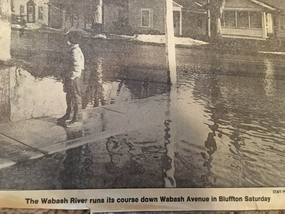
| Becky Osbun posted 3/17/1982. "Looking West across Ardmore Avenue. The Sports Club building is on right side of photo." Photo by Donald A. Weber. Remarkable to me how much has been done since then to alleviate this flood plain! Rod Consalvo we lost our service office GTE had 2 feet of water in Tecumsah had to installed 40 multi-line phones over the weekend to Berry Street 24x7 be we did it, right Roger Correa.Coulter Pine It is an old riverbed - the Little Wabash. Returning it to the water soaking habitats it used to be was a great decision for flood prevention and wildlife! |

 |
| Tommy Lee Fitzwater posted 1982, 4th St. area [I'm guessing it was around here.] |
 |
| Becky Osbun posted "But recently, I must say -- I flew to flood-stricken Fort Wayne, Indiana. And as I said last night in New York, I discovered that we still have that spirit we've always had. I saw again how Americans can rally together in times of trouble. Certainly it was a terrible tragedy for many people, but at the same time you had to be inspired by what you saw. My first sight was walking up to a dike -- the water was right at the level of the top of the dike and standing on that dike, hundreds of young people who had volunteered, standing there in a line and passing those heavy sandbags to keep that dike line up above the flood crest. One of them gave me his boots, and so I took my place in the line for a little while. A young lady told me she'd been there for 3 days. They were all volunteers, girls and boys from all backgrounds, all the mix that you would find anytime, anyplace in America, of the kind of people that make up an American group. And looking at their happy and enthusiastic faces while they were doing this -- and I heard they'd been there since early morning and it was coming on evening, then, and there was no griping about what was going on -- I just looked at them, and I thought I was looking at the face of the future in America. And I can tell you, the future looked mighty good." - President Reagan (http://www.reaganlibrary.gov/.../remarks-meeting-chief...) Pemberton Dr. photo courtesy Fire Fighter Album, ACPL [As I mentioned earlier, my sister was part of the crew that saved Pemberton Dyke.] |
1972 Flood


Steven A Cutter posted eight photos with the comment: "The “Flood” of 1978 … part two …"
 |
| 1 |
 |
| 2 |
 |
| 3 |
 |
| 4 |
 |
| 5 |
 |
| 6 |
 |
| 7 |
 |
| 8 |
 |
| Viral Hook posted Maumee River is a major river in the U.S. Midwest, best known for its role in history, shipping, and fishing. [Access the "posted" link if you are interested in his list of facts. A key fact: "One of the largest rivers feeding Lake Erie"] Ron Rowland: Under Key Facts: it is not one of the largest rivers flowing into Lake Erie...it is THE largest river flowing into the Great Lakes. [I'd think Canada would have larger rivers feeding the Great Lakes.] Kevin Millen: THE largest river that flows into Lake Erie -- or ANY of the Great Lakes . [Two votes for it being the largest. Actually, I came across some more votes in the comments.] Edward J. McHale: Once a commercial pilot reported a huge oil slick on the Maumee as it flowed into Lake Erie. Nope. It was Walleye! Michael MacCafetiere: famous originally for sturgeon. The St. Mary's name in Miami translates "sturgeon river". In truth, the St. Marys and the Maumee are one stream while the St. Joseph is a tributary of that stream. To read more about this, see the book _Native American Place-Names of Indiana_. Tricia Elaine Sanford-Speiser: The native people believed that the center of this yellow patch, Defiance, OH, held magical power. All water for nearly a hundred miles flowed to the center. This is why they chose this spot as the gathering for the largest meeting of native people known to history in North America. It was held near the Confluence of the Maumee and AuGlaize rivers. From the center of this one can work their way all the way to the east coast and the Atlantic Ocean via water. One could also travel via River all the way to the Gulf of Mexico, making just one short Portage in Indiana. Tomas Diaz: The Great Lakes are the result of a massive glacier that eventually receded to what we have today. The melting cycles of the glacier carved out and eroded the land scape that we have today. The St Joe and St Mary’s rivers were the shorelines of Lake Erie millions of years ago. East of Fort Wayne and all of north west Ohio was a shallow lake bed of Lake Erie. Excellent farm land now. Look at the current shore of western Lake Erie. It replicates the contour of the St Joe and St Mary’s that we have today. The 3 rivers were created. Ft. Wayne is called the Summit city. Kim Shoemaker: The black swamp Ron Rowland: Kim Shoemaker yes, the whole basin was the black swamp at one time. Yann Bandy: Very important passage to early French explorers and traders. With the help of the natives, they realized that a short portage from the Maumee to the Wabash would reduce the time needed to travel to the Ohio and Mississippi rivers. Also, another portage from the Auglaize led them to the Great Miami River. A VERY strategic area for exploration, travel, trade, and later war. Steven Harrington: The overall cleanliness of the river (yes I'm aware of the city of Maumee dumping raw sewage into it) is noticed with the return of bald eagles and sturgeon. David Milligan: At one time, when Lake Erie was at its maximum size, the Niagara outlet was still blocked by a glacier. The lake supposedly drained through a channel through the Maumee and into the Wabash. That made digging the shipping canal in the 1800s practical. [By "shipping canal," I presume it means the Wabash & Erie Canal.] Duff Parker: Please correct me if I am wrong but I always heard where it is the only river that flows to the north. Not sure if the is correct or not. Dennis DeBruler: Duff Parker Off hand, take a look at the Tennessee, Cumberland and Kentucky Rivers in Kentucky. Mike Hayes: And a great dumping ground for the city of Maumees raw sewage. Paul Kemner: And unchecked agricultural sewage turns the western half of Lake Erie green with toxic algae. John William Smith: Contribute about half the phosphorus to Lake Erie, hence the algal bloom problem. LJ Petersen: It’s also muddy: The Muddy Maumee! Mike Morris: Filled with waste from Campbell Soup in Napoleon and raw sewage from City of Maumee. Jim Morgan: Mike Morris incorrect, partially. The major part of the pollution is from factory farm animal waste. Jim Roehm: The Battle of Fallen Timbers ( near the mouth into Lake Erie ) was a SIGNIFICANT conflict that marked the sudden end of British arms support to the Miami Confederation. General A. Wayne led a reconstituted U.S. Army. Significant enough that it should have National Historic Battlefield status (with subunits for Harmar’s Defeat near Ft. Wayne, and at Ft. Recovery, OH.) Dane Ah Jonsoon: The largest watershed east of the Mississippi. Dennis DeBruler: Dane Ah Jonsoon Offhand, the Tennessee and Cumberland Rivers have to be larger. |
No comments:
Post a Comment