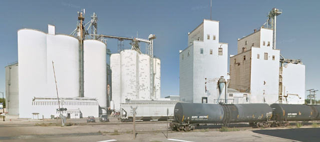
Ag Processing; (Satellite)
Since the wood elevators are being torn down, I'm getting a street view while I can.
 |
| Street View |
Dawson History posted five images with the comment: "A local landmark is coming down this week (photos July 20, 2022). The Farmers Co-op Elevator began in 1927 by buying the McCarthy Elevator and then adding the nearby Pacific elevator, Eagle Mill flour, and corn dryers. The three prominent buildings in the 1930s photo are on the 1943 map, starting with the extreme lower right coal shed and looking east to the corn dryer at the back. (Captions with each photo). In 1947 some of these buildings were torn down and a new elevator built. So, one of the structures going down may be more than 100 years old and the other is 75. As agriculture changed, so has storage and processing. Sad to see them go, but specialty buildings are not easily updated or repurposed. Farmers Elevator is now part of Canby Grain.
Post MK"
Adam Miller: Paul Hill at this time the plan is to take down the old wood elevator structure and two metal grain bins attached to it. The site will be cleaned up and leveled off. There are no construction plans currently for that spot, but the space will be available for future use and construction as the elevator needs.
John Harker shared
 |
| 1 View from Main. |
 |
| 2 These were bucket elevators: belt and buckets hanging in this photo. |
 |
| 3 View from west. |
 |
| 4 1930s photo from 1984 centennial history book |
 |
| 5 1943 fire insurance map. Bird's eye view of 1930 photo, before foreground buildings torn down for 1947 building. |
Canby is the small elevator in this town. The freight cars in the foreground are for servicing the AG Processing elevator. When I started analyzing the extent of the truck queue, I discovered that the elevator extends quite a ways north of the tracks.
 |
| Satellite |
When I saw all of the tank cars, I wondered if the plant produces corn oil, soybean oil or biodiesel. (It didn't have enough tanks to be an ethanol plant.) Their website indicates this plant produces crude soybean oil. I presume the covered hopper cars haul away the soybean meal.
A USGS map indicates that the railroad is BNSF. So I looked at a 1967 topo map to determine if it was GN or NP. To my surprise, it was C&NW! So how did a C&NW route end up in the BNSF instead of UP, which bought C&NW? Looking at a 1958 map, the route was marked Minneapolis & St. Louis. That means C&NW bought it, thus it was relatively easy for someone to sell it.
No comments:
Post a Comment