(
Satellite)
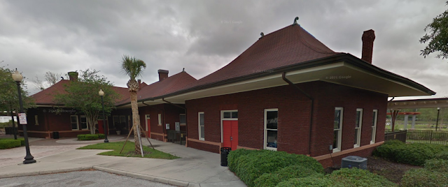
It is interesting that the platforms still have covers. I've seen a lot of depots that are still used for passenger service that no longer have their platform covers.
Randall Thornton
posted six photos with the comment: "Photos of Ocala SAL depot. This is where the SAL crossed the ACL. Building has been completely refurbished but not for passenger trains as there are none. But it is representative of great architecture."
 |
| 1 |
 |
| 2 |
 |
| 3 |
 |
| 4 |
 |
| 5 |
 |
| 6 |
This must have been a predecessor depot.
 |
Randy Jaye posted
Seaboard Air Line Railroad depot - Ocala, Florida. Florida Memory Photograph - ca. 1905. |
The oldest high resolution topo map is 1968, which is a year after the SCL =
ACL+
SAL merger. So I first used this low resolution map to determine which route belonged to which railroad. So the SAL was basically a north/south route whereas the ACL had all four points of the compass.
 |
| 1959 Gainesville Quad @ 250,000 |
The station looks like a bold number one and is labeled "Sta." Randall called this the SAL depot, but it appears to be a Union Station that served both railroads. SAL and the east/west route of the ACL went by the north side of the depot while the north/south route of the ACL went along the east side of the depot. In fact,
this article and
Google Maps label it Union Station.
 |
| 1968 Ocala West Quad @ 24,000 |
Of the six spokes that SCL had in Ocala, only the SAL route remains.


No comments:
Post a Comment