Saturday, June 28, 2025

Oak Ridge, TN: 1967-2023 765mw TVA Bull Run Power Plant

(Satellite)

Street View, Sep 2023

Tennessee Valley Authority posted
After decades of service to the region, the retired Bull Run site near Oak Ridge, TN, is being prepared for a new purpose — helping deliver reliable power for the future. We are exploring advanced technologies like grid-balancing equipment and energy storage, while gathering community input on long-term possibilities. The next chapter at Bull Run is just beginning. 💡
Eddie Rahm: Was once named the most reliable coal fired steam plant in the nation, based on run time verses outage time. I one inspected the turbine blades there for cracks. Found one cracked blade.

TVA
They are considering reusing the turbine building to house a synchronous condenser. The existing generator would be reconfigured to function as a synchronous condenser. The inertia of the rotor helps stabilize the network's 60hz frequency. TVA plans to add 10gw of solar power to the grid by 2035. 

A video in wate
The stacks were 500' (152m) and 800' (244m)

Facebook Reel

O'Fallon, IL: Chamber of Commerece/B&O Depot

(Satellite, the building has been moved away from the tracks.)

John Lillyquist posted
O'Fallon IL - Baltimore & Ohio Railroad Depot - ca 1915 Real Photo Postcard

Street View, Aug 2023

Trackside, note the agent's bay window.
Street View, Jul 2019

The map marks the location of the depot with a square instead of a rectangle. Illinois Terminal had the north/south route by the town.
1954/59 OFallon Quad @ 24,000

Ottawa, KS: Lost/MoPac Depot

(Satellite, MoPac used to run through town on 1st Street.)

Michael Emerson Avitt posted
Ottawa, Kansas.

1956 Ottawa North and South Quads @ 24,000 via Dennis DeBruler

Was this the foundation of the depot?
Satellite

This railroad is why there is still a huge fertilizer sales facility near the downtown.
Street View, Jul 2014

Friday, June 27, 2025

Red Fork, OK: 1884 Museum/Frisco Depot including Phillips 66 Gas Station

If you are here because of "Davenport, IA: 1924 Visitor Center/DRI&NW (Milwaukee+CB&Q) Union Station," then please go there.

Depot: (Satellite)
Route 66 Historical Village: (Satellite)


I learned of this historic park while studying old gas stations in Commerce, OK.
Dave Higgins, Apr 2024

Street View, Apr 2025

I included the old tank car in the left background. Oil is still an important part of this area's economy. There is a big refinery just northeast of here.
Street View, May 2022

Angela Duffield, Dec 2025


James Morgan, Jul 2023

This pump jack display is in the base of the derrick.
Colleen “C.R.” Ramsey posted

This road not only carried US-66, it carried US-169, US-75 and OK-33. The Frisco railyard in West Tulsa is still used by BNSF.
1956/57 Sapulpa North Quad @ 24,000

The depot rents event spaces.
route66depot_depot

route66village_train
Frisco 4500 Meteor Steam Engine
The ex-Frisco railroad locomotive #4500 was built in Philadelphia, Pa. in November, 1942 by the Baldwin Locomotive Works. It was assigned to pull the passenger train “METEOR” from St. Louis, Mo. thru Tulsa to Okla. City and back on a daily basis.
[This webpage also has before and after photos of the 1929 passenger car, 1917 tank car and 1938 caboose.]

route66village_train
Original Red Fork Depot:  Established in 1883, Red Fork, Indian Territory, became a major railhead for cattle drivers and later an important destination for oil field workers after the discovery of the Sue Bland No.1 and subsequent Glenn Pool oil deposits.

Fordville, ND: Wood Grain Elevators and Northern Plains Railroad

Railyard: (Satellite)
Grain Elevators:
West: (Satellite)
Old: (Satellite)
East: (Satellite)

Old:
Street View, Oct 2012

Chris Hennebry posted
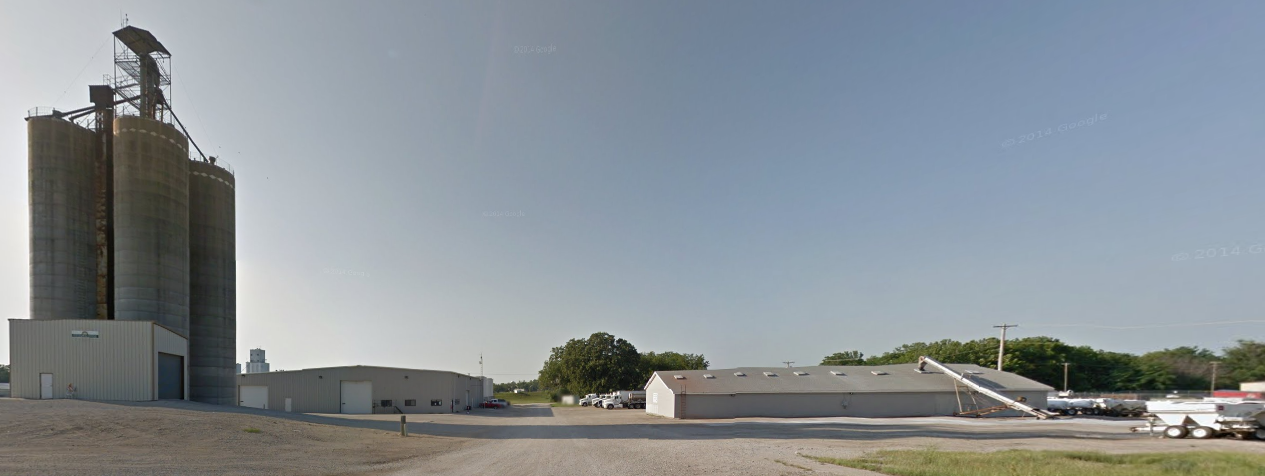
Not sure if this grain elevator in Fordville ND is still used or not.

Northern Plains Railroad was formed in 1997. It saved rail service on two segments of the SOO (Wisconsin Central) Railroad. Note the thick "dashed" blue lines.
2020 Map via nprail

West:
Street View, Aug 2012

I saved the above view because it was taken a few months before most of the street views in this town, and it captures a couple of MoW cars on the elevator spur. This view is what allowed me to identify the ballast cars. I think the yellow critter is a tamper. I think this elevator is a feed mill and no longer needs its siding. So the railroad uses it for MoW storage. It is always nice to see a shortline with MoW equipment because that means they are taking care of their tracks.
Street View, Oct 2012

East:    It looks like they are building a big steel bin (the circular concrete foundation). And I see a yellow fall protector so this elevator ships by rail.
Satellite

This town had a roundhouse.
1963 Fordville Quad @ 24,000

The railyard still does locomotive servicing, and it still has its turntable. In the upper-left corner a locomotive is actively working. And there are two parked at the engine house and seven in storage.
Satellite

Virden, IL: Lost/C&NW Depot

(Satellite, this route still has a well-defined treeline to the north.)

Chicago & North Western Historical Society posted
Someone wanted to see photographs of C&NW station stops to the west of Springfield, Illinois.  This is the line which ran south from Nelson, Illinois through Peoria and South Pekin all the way to Pontoon Beach, Illinois outside of St. Louis.  We hold only a rare few photos of such station stops on that line.  This one of Virden was taken in 1949 by an unknown photographer.
Jack Sartoris: IIRC, the station in Benld looked like this, too..
Michael Basso: Did the line NOT terminate in Madison?
Bill Edrington: Michael Basso - Madison Yard was the end of CNW-owned track, with trackage rights between Madison and Bridge Junction (East St. Louis) over the IT. The portion of the line below DeCamp Junction was the former Litchfield & Madison, acquired by the CNW in 1958.
Guy Ward: Nearby was the Virden coal mine. C&NW unit trains took coal to either Commonwealth Edison near Chicago or Wisconsin Electric near Racine. I forget but Virden was one of three mines that we served. The others were Elm just west of Peoria and Monterey much further south.
Joseph Obrien shared
Sissy Ewing-Hutcheson: I wonder where it was?
Robert Sullivan: South of Pekin this C&NW line largely avoided town as it went to the coal mines around southern Macoupin County and junction with the Litchfield and Madison RR.
Joseph Obrien shared

Tim Howard commented on the above post
Thank you, here is the layout west of the Village:
Dustin Newton: Tim Howard thank you. I've lived in Virden for almost 5 years now and have been wanting some information about the raillines that run through and just west of town. From my house I'm able to watch the BNSF go under the C&NW viaduct by Cemetery Rd.

Tim Howard commented on Dustin's comment
No problem. That's the old CB&Q Viaduct and there is a bg arched culvert over Sugar Creek:

Tim Howard commented on Guy's comment
Here is the interchange with CB&Q and Siding Layout

Tim Howard commented on Guy's comment
Royal Colliery, Royal No. 2 Mine

Dennis DeBruler commented on Sissy Ewing-Hutcheson's comment
It was west of town, https://maps.app.goo.gl/RQFWFpWiu1A8ajQ28. There is still a treeline on the route north of here. 1939 aerial photo


Thursday, June 26, 2025

Alna, ME: Wiscasset, Waterville and Farmington Railway Museum Roundhouse

(Satellite, they already have a turntable)

Wiscasset, Waterville and Farmington Railway Museum posted six photos with the comment:
Engine House Project - Work on the east side / pit stall this week. Photos by C Stewart Rhine, see captions for details.
Big thank you to Maine Narrow Gauge Railroad Co. & Museum for... see caption.
Wiscasset, Waterville and Farmington Railway Museum shared with the comment:
New wooden enginehouse going up at Maine's Wiscasset, Waterville and Farmington Railway Museum.
Gary Smith: How much trackage in feet or miles?
Wiscasset, Waterville and Farmington Railway Museum: Gary Smith 3.5 miles of mainline track. Hundreds of feet of yard tracks and sidings.
1
Much progress was made during the Fall Work Weekend including construction of the roof overhang with soffit panels. Also, one section of frieze board with tar paper was installed on the east side. See the next panels for news on track work.

2
The track crew began laying track in the pit stall on Monday. Here, Dana Deering crops the turntable feed rail as Joe Fox watches from inside the pit. This view looks north.

3
The rail stanchions were brought in by the track crane and set in place by the pit crew.

4
The pit crew, led by Dan Malkowski (in the black hoodie) plotted the location of the 18 stanchions to be ready to accept rail which will be craned in by "Elmer" seen through the doorway.

5
The next step was to begin setting the 80 pound rail sections. This view shows the first two sticks of rail set in the north end of the stall.
These rails were donated to the WW&F by the Maine Narrow Gauge Railroad Co. & Museum - Thanks!

6
Afternoon rain ended Mondays work but not before the pit rails were connected to the house track. The support stanchions will be bolted to the pit floor and rail attached to the stanchions after the next pieces are set in place.
Kennebec, Penobscot & Northern HO scale railroad: One question? How will the rails be attached to the stanchions? Welded? Bolted? Other?
Wiscasset, Waterville and Farmington Railway Museum: Kennebec, Penobscot & Northern HO scale railroad Bolted using track clips.

The WW&F Railway traces its roots to 1894 when the Wiscasset and Quebec Railroad constructed a two-foot “narrow” gauge railroad northward from the bustling wharves of Wiscasset. Far short of its international delusions of grandeur, the railway of “big dreams and little wheels” only reached Albion, Maine....The WW&F served the businesses and residents of rural Maine until 1933. [Facebook]

I used a roadmap instead of a satellite image because the narrow track is kinda hidden by the tree canopy.
Map
[The faint grey line west of ME-218.]

The dotted red line shows Albion. Wiscasset is in the middle about a fourth of the way up from the bottom. It is along US-1. According to a 1948 topo map, Maine Central not only ran along the coast, it had a route up the Kennebec River just 10 miles west of the WW&F. And even though it went through a lot larger towns, it appears that river route also has not survived.
Satellite