 |
| Steve OConnor shared Can anyone identify which rail line is which in this photograph from Lincoln, Illinois? The factory was built on a triangular-shaped area near the intersection of the Chicago & Alton, Illinois Central, and Illinois Traction System (ITS, interurban) railroads.
Bill Edrington The view in the black-and-white photo basically looks west. The Alton/GM&O main line crossed both the IC's Peoria District and the IT main line at Athol (JN Tower). The tower sat on the right side of the GM&O if you were going from Springfield to Bloomington, and also on the right side of the IC if you were going from Decatur to Peoria. The IT crossed both lines here after paralleling the GM&O through Lincoln, and then headed straight north toward Mackinaw Junction.
|
 |
| Steve commented on his posting |
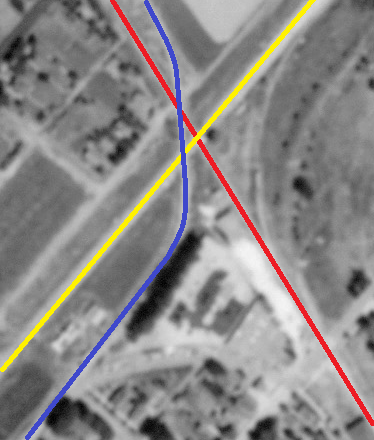 |
| 1940 Aerial Photo from ILHAP Dennis DeBruler commented on Steve's posting I marked a 1940 aerial using red for the Peoria, Decatur & Evansville branch of the IC, yellow for the GM&O, and blue for the Illinois Terminal. |
 |
| Dennis DeBruler commented on Steve's posting Using the same color conventions, I marked up the photo. |
 |
| Dennis DeBruler commented on Steve's posting The third leg of the triangle was an industrial spur. You can see a boxcar parked at the building. I put the spur in orange and the Main Business Entrance side along Kickapoo Street in purple. |
No comments:
Post a Comment