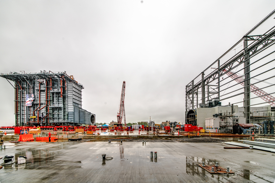
Unit 5 is a $550m, 485mw natural gas plant that replaced the 400mw coal-fired plant in 2019.
The coal-fired Unit 3 plant.
 |
| PSEG-history The first unit was built in 1957. But 1968 four units were operating. The first unit was retired in the 1990s. The 170mw oil-fired Unit #2 was retired in 2012. In 2002, the 410mw Unit #3 was converted to burn low-sulfur sub-bituminous coal. "Unit 4 is a 22 Megawatt Combustion Turbine that is capable of rapidly responding to emergency needs for electricity." In the 20th Century it was a baseline plant, but Unit 3 switched to providing "additional electricity to the Bridgeport area during extreme hot or cold weather periods....Both Unit 3 & 4 were instrumental in providing electrical generating capability for the Bridgeport region during Superstorm Sandy in 2012 and during the prolonged and extreme cold weather during the polar vortex in the winter of 2014." |
The gas fired Unit 5 plant.
 |
| PSEG-history The HRSG (Heat Recovery Steam Generator) is 10 stories high and was shipped to here from Albany using a 400' barge and three tugboats. |
 |
| PSEG-unit5 This is a 485mw combined-cycle plant that needs only 20 people to run it. It can use "ultra-low sulfur distillate (ULSD) as a back-up fuel." I can't tell if ULSD means diesel fuel or heating oil. Actually, the difference between the two is taxes and federal regulations. [YourFuelSolution] |
I'm saving this satellite image because it still has a coal pile.
 |
| 3D Satellite |
 |
| EnergizePSEG "Unit 3 went commercial in 1968. It was built to burn fuel oil and coal, but didn’t start to use coal as its fuel supply until 1985. Coal had become the cheapest fuel available, so it was an economic decision....That stack is 497 feet tall, and it can be seen for a 20-mile radius. There have been a lot of questions about whether the stack will remain – and for the time being it will because it’s part of the region’s FAA charts; pilots use it a landmark to land at a nearby airport." |
 |
| EnergizePSEG |
Three of several photos of moving the HRSG from the barge to the plant.
 |
| a |
 |
| b |
 |
| c |
 |
| Jim Capasso posted, cropped Bridgeport Harbor Station, last coal burner in CT. Shutdown |
 |
| Frank Romano posted Where I spent the bulk of my 40+ year career in the electric power industry. Picture taken on 2-14-2015 in Bridgeport, CT. Old tech in back, new tech in front. The coal-fired old tech is cold iron now, the gas-fired new tech is carrying the load. |
%20Power%20Plant%20Pictorial%20_%20Where%20I%20spent%20the%20bulk%20of%20my%2040+%20year%20career%20in%20th.png) |
| Comments on Frank's post |
 |
| 1 of 9 photos posted by Jim Capasso Warming up the dozer. [It was a D10] [Most of the photos are artsy photos of interior details.] |
 |
| Jim commented on his dozer photo. This was on top of our coal pile. |
 |
| Dave Krider commented on Jim's second post New air cooled condenser at Bridgeport Harbor CT. |
I was surprised that they converted Unit 3 to burning low-sulfur coal in 2002. The east coast is a long ways from the Powder River Basin in Wyoming. Then I learned that they imported the coal from "the human rights violating mining company Adaro, which mines in Indonesia's South Kalimantan region Indonesia's South Kalimantan region." In 2012, "The NAACP's 2012 report "Coal Blooded: Putting Profits Before People" ranked the Bridgeport plant as the tenth worst coal plant in the nation in terms of environmental justice. The report states that the plant emitted an average of 2,044 tons of sulfur dioxide and 1,404 tons of nitrogen oxide between 2007 and 2010. The average income of people who live within one mile of the plant is $11,400, and over 87 percent of them are people of color." [gem]
The following is an interesting statement: "All of the generation units at Bridgeport Harbor Station produce a total of 884 megawatts of electricity." [NHregister] But never did all of those units run at the same time. I don't know the capacity of Unit #1, so I don't know what the max capacity was in the 1970s and 80s.
 |
| PowerMag [I guess the blue "tanks" are coal hoppers.] |
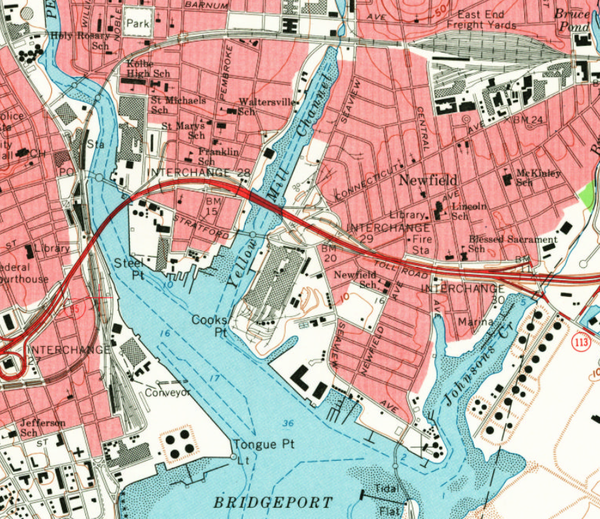
When I checked out the ship unloading facility on a satellite map, I noticed that this plant doesn't have any rail service. It has to receive coal from ships. This topo map shows that there was a nearby railroad. It was the New York, New Haven & Hartford.
 |
| 1951 Bridgeport Quad @ 1:24,000 |
In fact, the plant was built on a land fill next to the railroad. The next available topo map, 1984, shows that only the mainline is left west of the river.
 |
| 1970 Bridgeport Quad @ 1:24,000 |
No comments:
Post a Comment