(
Satellite)
Rick Giles
posted six photos with the comment: "Larry Stone: Like Cory said, LS&MS, not Big Four. Big Four had a branch to Sandusky (long abandoned) from the southwest but the bridge wasn’t part of it. Cold Springs was a significant location on the old Big Four Cincinnati Division. It was the tower that controlled the junction with the Erie's Dayton branch from Marion, Ohio which the Big Four would use to avoid the bottleneck through downtown Springfield. The Dayton branch would join with the Big Four's Cincinnati Division main line to Cincinnati to form a paired right of way with the Erie being the westbound main and the Big Four being the eastbound. The plant also included a turnout west of the tower that sent trains onto the Springfield branch that was the back way into Indianapolis. The first photo is the view looking geographically and timetable west down the Big Four main. It shows the crossover all eastbound trains would use to get on the Erie to Glen Echo where Big Four trains would rejoin home rails. In the second photo the DT&I's eastbound DC-8 is using this crossover to run up the Erie to Maitland where it will use the connecting track there to get onto DT&I rails. The third photo shows a PC manifest from downtown Springfield coming off the Big Four main onto the crossover over to the Erie and is just about to foul the eastbound crossover from the Big Four main. In photo number four, the Conrail train is swinging around the curve on the connector to the westbound Erie main. Cold Springs was originally just an armstrong interlocking plant and photo five shows some of the levers and the trackage layout on the model board. In later days on the New York Central, Cold Springs was used as a control station for the Control Points in downtown Springfield. The last photo shows the control panel and trackage layout in downtown Springfield in the early PC days. In Big Four days there was a significant amount of export coal that was interchanged from the L&N at Cincinnati that went to Sandusky, Ohio on Lake Erie that went up the Erie. All trains not having work to do in downtown Springfield used the Erie as well including all the Cleveland and Toledo hotshot manifests. After the CSX and Family Lines merger, and the opening of Big Four yard in Indianapolis, less traffic came through Cold Springs. That being said it was still a significant enough facility to remain open well into Conrail days finally closing sometime in 1986 I believe.DB is still active under NS ownership and sees Amtrak’s Lake Shore and Capitol Limiteds."
Cory Behrendt: Cold Springs lasted until '91 I believe. Cool photos!
 |
| 1 |
 |
| 2 |
 |
| 3 |
 |
| 4 |
 |
| 5 |
 |
| 6 |
 |
Jon timothy Wilkins commented on a post
I have a dispatching simulation that has a Cold Springs-Springfield track simulation that you might find interesting.....it is a long jpeg so you might want to download it to view it more closely. |
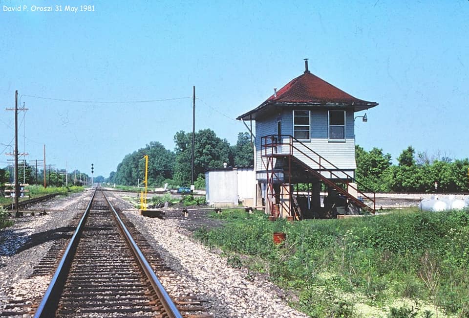
Darren Reynolds
posted five photos with the comment: "Cold Spring tower. (CS) Springfield,OH. 1987-88 Photos by Rich Ballash Don't know RR??"
Christopher Allen Howe: The original railroads at Cold Springs were the NYC Big Four, the Erie, and the P&E line to Indianapolis(also an NYC owned RR). It also controlled where the PRR connected to the NYC at Springfield from its Branch out of Xenia.
 |
| 1 |
 |
| 2 |
 |
| 3 |
 |
| 4 |
 |
| 5 |
Because the P&E became part of the Big Four and because the Big Four became part of the NYC, I had to go back to a really old topo map to find a distinction between the P&E and the Big Four. Note that the P&E joined the Big Four mainline in the upper-right corner of this excerpt.
 |
| 1906 Springfield Quadrangle @ 1:62,500 |
By 1955, NYC built a bridge across the Mad River and curved down to join the Big Four mainline west of Cold Springs. Part of the original P&E route was abandoned and the old route out of Springfield evidently became an industrial spur.
 |
| 1955 Donnelsville and Springfield Quadrangles @ 1:24,000 |
In fact, the new bridge still exists even though the P&E route is now abandoned.
As recently as 1962, the larger scale maps showed the old P&E route. It could not find where P&E, Big Four and Erie crossed each other until I found the above 1955 map. I was using the larger scale maps to include where the Erie met the DT&I and Big Four on the north side of town.
 |
1962 Columbus Quadrangle @ 1:250,000
|
The 1967 map does reflect the new route for the P&E. Today, the Indiana & Ohio Railway (IORY) shares the NS/Big Four route southwest of Cold Springs. And the Erie remnant on the west side of town is still used by the IORY to access its DT&I route. And that remnant continues to connect with the Big Four route north of town, which is now owned by the Indiana & Ohio Central Railroad (IOCR). The circuitous Big Four route through town is now the
Simon Kenton Trail.
 |
| 1962 Columbus Quadrangle @ 1:250,000 |


No comments:
Post a Comment