This is the first photo I have seen of the Ohio & Erie Canal outside of Cleveland, OH.
 |
| Steven Marshall posted Massillon, Ohio Pete Smakula: The canal went through Massillon. The river was re-routed to go around town and a big levee was built. The towpath trail is on the levee. There is a small bit of evidence that you would never notice on a few century+ buildings.As the railroads took over the canal became obsolete, but many people tied up their boats and made the canal home. All that went away in the 1913 flood. Linda Smith: Wonder if this was the time Massillon flooded on Erie or First. A friend said she had to take a boat to get to work in the Massillon bldg and was carried in to take stairs up to the then telephone office. Must have been a scary time. Then the viaducts were built. Bret Stephan: I read that there were less than ten boats running the final year before the great flood that caused so much damage, that it was not worth the investment to repair. Pretty sure that's looking north. On the right is the back of the properties on Erie Av. The left was derelict buildings that sat in the area between the river and Canal. Dennis DeBruler: Bret Stephan While researching the steel mill that was in this town, I found this resource: Its caption for this photo says it is looking south from Tremont Avenue bridge. Terry Ritchie: The areas in the towns where the boats stopped to offload or take on cargo were somewhat like the wild west... Bars, brothels, fights and general drunkenness were common. I knew a couple of gentlemen long deceased who told stories about the canal 'businesses'. They were just kids then and told me that when a boat or boats stopped they would find a hiding place near the area and watch the show. Very Huck Finnish.Tom Carroll Eastridge: I know they filled a great need at the time but the canals, for the most part, looked pretty nasty and not well-engineered. Hal Marker:Tom Carroll Eastridg eCanton said no to the canal due mosquitoes carring malaria. Also the 1st train company that went to the east and started Alliance. Bob Ebbeskotte: Tom Carroll Eastridge I live in Delphos on the Miami and Erie Canal. They were amazingly well engineered. They were built in the wilderness of Ohio mostly by German and Irish immigrants. They traversed Ohio over flat land, across valleys and rivers. From Lake Erie the Miami and Erie Canal went up over 500 feet to the Loramie Summit then back down to the Ohio River through over 100 locks that raised and lowered boats. It was an amazing structure. This picture shows a canal with very low water. Perhaps they lowered the water level for lock or canal maintenance. If the water was higher this canal would be functioning as planned and look much better. |
 |
| Terry Ritchie commented on Steven's post I adjusted it slightly... |
 |
| Bret Stephan commented on Steven's post Pretty much every trace of it was destroyed in the early 50s when route 21 was put in. The canal ran behind the buildings on erie Ave, south of Lincoln Way. An entire manufacturing community was located between the canal and river.Artists rendering of the original industry that existed between where the river original was and the canal that ran behind the properties along Erie Ave. The view is looking north from about Finnefrock St. [Finefrock Rd] 1870 |
 |
| Bret Stephan commented on his comment |
Bret Stephan also provided these comments:
Pretty much every trace of it was destroyed in the early 50s when route 21 was put in. The canal ran behind the buildings on erie Ave, south of Lincoln Way. An entire manufacturing community was located between the canal and river.The Canal ran behind the buildings on the west side of Erie Ave. In certain areas it was where the northbound lanes of Route 21 currently are.They widened the river extensively. The canal crosses rt 21 at the intersection of Lake St. then veers into the southbound lane again and then to the northbound lane. Around Cherry St it ran west of the northbound lanes and ran parallel to the rear lots on erie Av.When brown lumber was built, that's how they shipped and received their lumber. Just north of finefrock rd, there was a set of dual locks.
 |
| History Hub posted Canal boats lined up in a lock on the Ohio & Erie Canal in southern Massillon, Ohio. c. 1900. Lloyd Scott Hardin shared |
The canal allowed the coal mines in the area to ship coal to Cleveland to fuel Lake Erie steamers. Unfortunately for the canal, the beginning of the end happened on Mar 11, 1852, when the first train arrived in town. Later, the coal fueled the local industries of glass and steel. "Massillon’s production of steel became so popular that it “was the world’s largest cold rolled stainless steel strip mill”" [MassillonMuseum]
I accessed a low-res topo map to better understand the railroads in the area. The oldest I could find was 1951.
It still shows the route of the canal because it was filled in during 1951 as part of the flood control project. [MassillonOhio]
 |
| 1951 Canton Quad @ 250,000 |
Steel Mill
While studying the satellite map, I noticed the following.
 |
| Satellite |
That is probably the "land scar" of a steel mill. So I researched it.
It started in 1902 with the Massillon Rolling Mill Co. The mill became the Central Steel Co. in 1914. It merged with Republic Steel in 1930. The steel plant ended in 2002 by one of Bethlehem Steel's successors. "In its heyday, the company was the world’s largest producer of finished stainless steel, the third largest steel company and, for Massillon, the city’s largest employer." [indeonline,]
.jpg)
.jpg) |
| eBay |
The plant had a blast furnace:
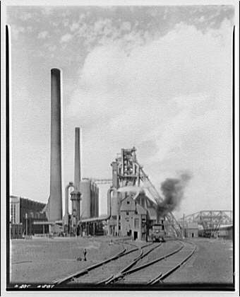 |
| LC-H814- 0574-006 [P&P] Steel mill, Massillon, Ohio. General scene, Central Alloy Steel Corp. |
 |
| hagley "Blast furnace, Republic Steel Corporation (Massillon, Ohio) "The Republic Iron and Steel Company was established in 1899 through a consolidation of various rolling mills and blast furnace plants. It acquired Central Alloy Steel Company in Massillon, Ohio in the 1930s. "Hagley ID, Box/folder number, American Iron and Steel Institute photographs and audiovisual materials (Accession 1986.268), Audiovisual Collections and Digital Initiatives Department, Hagley Museum and Library, Wilmington, DE 19807" [ an estimate is that this photo wsa taken in the 1930s.] |
And then an Electric Arc Furnace:
 |
| LC-H814- 0574-010 [P&P] Steel mill, Massillon, Ohio. General view of electric furnace |
 |
| LC-H814- 0574-009 [P&P] Steel mill, Massillon, Ohio. Drawing sample of molten metal from electric furnace |
 | |
| LC-H814- 0574-008 [P&P] Steel mill, Massillon, Ohio. Electric furnace tilted up for pouring off molten steel |
Another source identified this as the coke plant.
 |
| LC-H814- 0574-006 [P&P] Steel mill, Massillon, Ohio. General scene, Central Alloy Steel Corp. |
The steel mill was served by the NKP/W&LE Railroad.
 |
| 1961 Massillon Quad @ 24,000 |
The following two images come from AllAboardRails concerning a simulation of the plant.
 |
| 1 |
 |
| 2 |
B&O Depot
Bob Weston posted two photos with the comment: "Two views of a tower controlling a road crossing the Baltimore and Ohio and Wheeling and Lake Erie Railroads in Massillon, Ohio. Date and photgrapher unknown. Photos from the Ohio Railroad Stations Past and Present website."
 |
| 1 |
 |
| 2 |
No comments:
Post a Comment