 |
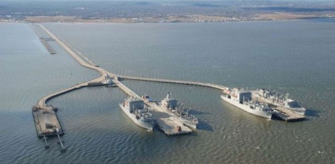
| Mark Krieg posted USS Wisconsin (BB-64) on-loading ammunition at Pier 4 in Naval Weapons Station Earle, NJ, March 1990. Jan Renstead fear of munitions explosions in port is not unwarranted.“Seventy five years ago, on the evening of July 17, 1944, an explosion at a Naval base on Suisun Bay ignited 10,000 tons of munitions, killing 320 and injuring hundreds more. It was the worst home port disaster of World War II, destroying two ships and destroying the nearby town of Port Chicago.” https://www.sfchronicle.com/.../Port-Chicago-disaster... [paywall, see below for some videos] Marc Kaplan shared Clyde Hendrickson shared Railroad loading of Navy ships. Matthew Fish: The largest finger piers in the world. Matthew Fish: It’s 4 miles long to provide blast protection to shore properties and people. Gilbert Porter: Is that little barge next to it for all the empty spent casings? Jim Colvert: Gilbert Porter Most likely Navy Divers inspecting her hull and providing underwater security. It was common for the guys to work off barges doing these jobs. Brooke Balbach: I worked for the Santa Fe and we used to haul unit trains of Ammunition in boxcars in and out of the Naval Weapons Station Port Chicago Ca. It was a great experience to be a part of. Matthew Fish: Brooke Balbach part of the reasons these piers were built was the Port Chicago disaster. 𝗥𝗲𝗺𝗲𝗺𝗯𝗲𝗿 𝗪𝗵𝗲𝗻: 𝗡𝗲𝘄 𝗝𝗲𝗿𝘀𝗲𝘆 & 𝗡𝗲𝘄 𝗬𝗼𝗿𝗸 posted USS Wisconsin at the Naval Weapons Station • Earle, New Jersey • 1990! John Eken: One order of 16" shells, 50 tons of bunker oil and Taylor Pork roll for the crew...make it snappy!! Mike Southwell: John Eken. More like 8850 tons of Fuel oil. Bunker C in the 40s and 50s. Marine Distillate oil in the 80s. Bill Koropatnick: The main ordnance storage magazines are located back at main base along routes 34,33 and 18. Munitions were either ferried by rail or MV to the pier. At times the convoy would be supported by an armed Marine escort which included armored vehicles. I would on occasion pickup Sonobuoys for my ASW squadron at NAS Lakehurst along with small arms ammunition survival pyrotechnics. Jeff Taylor: Bill Koropatnick. I mentioned above, did several construction jobs in the base and on the pier. Whenever anything moved, all other vehicles or work was required to stop, lights flashed like Nascar yellow flag on every light pole to warn you. The Marine guards stood behind sandbag barriers with shoot first, ask who you were orders...we always obeyed...way back in the woods is a railroad yard filled with vintage boxcars, some very rare, the military never throws anything away, the base is filled with old equipment parked everywhere.... James Cook: The longest Naval pier in America Just about 3 mls [miles?]. Doug S Ward: Back in the early 60s our Club Scout Troop from Neptune attended Armed Forces Day at Earle. The whole troop plus parents rode in the back of a stake body tractor trailer. Couldn’t do that today! We toured all of Earle and ended up on the pier to tour a ship docked at the pier. Jeff Taylor: It's been expanded to accommodate more ships at once, see it all time fishing the bay.... |
Some comments on the "𝗥𝗲𝗺𝗲𝗺𝗯𝗲𝗿 𝗪𝗵𝗲𝗻: 𝗡𝗲𝘄 𝗝𝗲𝗿𝘀𝗲𝘆 & 𝗡𝗲𝘄 𝗬𝗼𝗿𝗸" questioned if this was the pier at Earle including:
 |
| Patrick Colligan commented "it looks like it was here." |
 |
| Jay Narvell commented on Clyde's share [They moved the access from the sides of the turret to the back of the turret after the Royal Navy had a flash into their magazines.] |
 |
| Vincent Gong commented on Clyde's share, cropped Caught USS Bataan leaving NWS Earle two years ago! |
This map shows that the circular woods up by Sandy Hook Bay is part of the Naval facility. But the main facility is south of NJ-18.
 |
| USGS |
The pier is three miles long. My first thought was it had to be that long to get into the deep water needed by big ships. But some comments on the post speculated that it was to protect the shoreline in case there was an accident while loading a ship.
 |
| Satellite |
Looking at the base itself, we see many clusters of bunkers such as this one.
 |
| Satellite |
Different clusters have different spacings of the bunkers. The reason for the spacing is so that if one bunker explodes, it won't cause adjacent bunkers to explode. So evidently more powerful explosives need a bigger spacing.
When I looked at some topo maps, it appears that this was the original base. It looks like this part is now used to park railcars. The railroad that connects the storage facility with the pier facility follows Normandy Road.
 |
| Satellite |
The first sign I found was unreadable. But this sign verifies that civilians are not allowed on Mormandy Road.
 |
| Street View |
This article states that the reason for the long pier is to keep the loading of explosives far from the shore.
 |
| safe_image for This Trident-Shaped Munitions Rail Runs Three Miles Off the NJ Coast |
Even though the photos are duplicates, I include this post because there are several interesting comments on it.
Jesse Arias posted two photos with the comment: "I borrowed these pictures from the Military History website. This is the battleship USS Wisconsin (BB-64) loading ammunition at Pier 4 East of the Leonardo Pier Complex at the Naval Weapons Station in Earle, New Jersey in March 1990. Does anybody know if this railroad pier is still operational or in existence?"
Jared Haase: the pier is 2+ miles out into the water to prevent/minimize any damage to the local civilian population.
 |
| 1 |
 |
| 2 |
 |
| Len Komar commented on Jesse's post Yes still operational |
No comments:
Post a Comment