Saturday, May 31, 2025

Austin, IN: Lions Club/Pennsy Depot and Caboose

(Satellite)

I think this Pennsy route between Louisville and Indianapolis was assigned to CSX. But CSX didn't want to run it so the Louisville & Indiana RR (LIRR) railroad now has it. But a few years ago CSX decided it needed to use that route. So they paid to upgrade the track, and now they use trackage rights on the route. [2019 map]

Street View, May 2023

Jabier mendez, Nov 2017

Dean Moore posted three photos with the comment: "Austin Indiana. 1930s Pennsylvania Railroad depot, now the lions club building.  Caboose was previously yellow."
Dean Moore: If you go, there is a very rare walk-up only vintage Dairy Queen right across the street. I felt like I was 13 again...
Tim Shanahan shared
1

2

3

Yarmouth, IA: CB&Q Railroad Action

(Satellite, the land has been reused.)

John Harker posted three images with the comment: "When Charles Franzen photographed this scene, CB&Q west bound mixed local train 23 was on the Washington, Iowa branch just coming into Yarmouth on the morning of December 31, 1965.  Charles had his camera pointed toward the southeast.  If you look to the lower left of the image, you can see the brick platform for the depot where he was standing.  There was a siding to the left that ran by the building and the anhydrous storage tank.  Also, there was a siding further to the northwest for the elevator.  The power for this train was SW7 9262 and it was pulling, as I counted, seven cars plus a caboose.  Attached for reference is an employee timetable and a 1960s Iowa Geographic Map Service aerial view with a red arrow pinpointing the depot.  Note, in the timetable the average speed on this branch was a little over 15 mph.  John Harker image editing, research and collection"
1

2

3

1902 via Dennis DeBruler

A satellite image shows that the concrete silos no longer exists. It is expensive to remove concrete silos, so normally they are just abandoned.
Street View, Sep 2009

They evidently removed all of the 2009 stuff to make room for five new bins.
Satellite


Northfield, NH: 1880,1990 Event Space/Boston & Maine Freight House

(Satellite)

Street View, Aug 2019

Tom Weber posted
The historic freight station in Northfield, NH is host to a large number of privately-owned cabooses in my photo taken on October 14, 2023.
Originally built in the late 1800’s, the building was restored in 1990 as a wedding and event center and named the Merrimack Valley Railroad Station.

Street View, Aug 2023

Photo, Dec 2024


Friday, May 30, 2025

Los Angeles, LA: Hobart Junction Tower and BNSF/Santa Fe Hobart Yard

Tower: (Satellite)
Yard: (Satellite)

Paul Jansson posted
On 12/20/1991 the much anticipated run of the newly restored ATSF 3751 is seen passing Hobart Tower.
Dennis DeBruler: In which town? It doesn't look like either Bart nor HO in Hobart, IN. Assuming Hobart, IN, is it westbound on the EJ&E and crossing the Pennsy?
Paul Jansson: Dennis DeBruler it is Hobart Tower in Los Angeles with Santa Fe’s Hobart Yard behind it.

Dennis DeBruler commented on Paul's comment
Thanks. Judging by your photo and others, the tower was in the northeast quadrant of the junction, https://maps.app.goo.gl/CvyLVBzP3BYPTRA26. I see UP has a yard just north of the BNSF/Santa Fe yard.
Paul Jansson: Correct, gone now.
The tower was actually for the Union Pacific and protect their San Pedro line going down to the harbors.

emd Flickr
Union Pacific Stock Cars Returning To East Yard At Hobart Tower
[Note the stockyards on the above topo map south of the river.]

Jul 10, 1948 @ 20,000; AR1HD0000020049

The yard is now an intermodal yard.
Street View, Nov 2024

Dyana Gonzalez, Sep 2019

bnsf

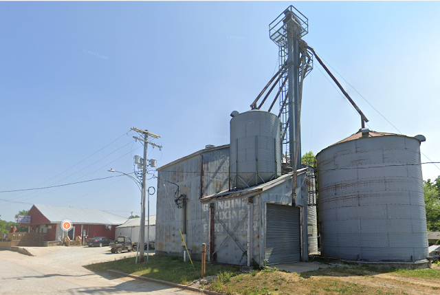
Downing, MO: Lost/CB&Q Depot and Wood Grain Elevator

Depot: (Satellite)
Feed Mill: (Satellite, I couldn't force Google Maps to drop the pin on the wood elevator itself.)

Michael Emerson Avitt posted
June 10, 2006 - CB&Q depot at Downing, Missouri.
Dennis DeBruler shared

Dennis DeBruler commented on Michael's post
Where is it now? According to this 1964 aerial, it was about here: https://maps.app.goo.gl/nzsvZUyMGd5kmCXr5.
Raymond Phil Garmoe: Dennis DeBruler it's still there

Dennis DeBruler commented on Raymond's comment
Raymond Phil Garmoe I looked again. All I could find in that area is a propane tank, https://maps.app.goo.gl/8gkGH57ADZJR6MX36.

The topo map correctly indicates that the depot had a house track.
1966/67 Downing Quad @ 24,000

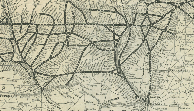
It was on the branch that meandered West of Keokuk.
Dennis DeBruler commented on his share
It was on the branch that meandered west of Keokuk.
https://collections.carli.illinois.edu/digital/collection/knx_rail/id/298

Street View, Jun 2023

Street View, Oct 2016

Wilmington, DE: Pennsy Bell/Bellevue Tower

(Satellite? if it was here, it is no longer extant.)

Robert Braune posted
Bell Tower
Former Penn Central RR
Wilmington Delaware
So sad to see this decay. These towers were a vital tool and served a great purpose for our country for many years. Wish there was a Society in place to preserve them.
[This implies it still exists, but I spent some time looking for it and could not find it.]
Jim Kelling: I read that it was actually named “Bellevue” by the PRR but was shortened to BELL in the Penn Central era.

The hollow rectangle near the upper-right corner of this excerpt is my current theory.
1954 Wilmington North and 1948 Wilmington South Quads @ 24,000 via Dennis DeBruler

worthpoint
7/7/76

If my satellite guess is correct, then the power lines have been upgraded.
Street View, Mar 2020

rrpicturearchives, Ben Franefeld
"BELL Tower was named after the Bellevue section of Delaware in which it stands. It was constructed of brick, poured concrete, and a slate roof. The structure does not have a bay window like many other traditional PRR switch towers. BELL once controlled the interlocking at the north end of Edgemoor Yard."
[Is that Governor Printz Blvd. in the left background? This description is consistent with my guess for the satellite location.]

Note the tower in the distant background on the right side of the tracks. This description is also consistent with my satellite guess.
TheTracksidePhotographer

Thursday, May 29, 2025

London, OH: Junction Tower: Pennsy vs. Big Four, Freighthouses and Pennsy Depot

Tower: (Satellite, the connection between Big Four West and Pennsy East was added on the tower's land.)
Pennsy Depot: (Satellite, it is extant.)
Pennsy Freight: (Satellite, it has been moved. [west2k])
Big Four Freight: (Satellite, [west2k])

Tyler Dixon posted four photos with the comment:
Pennsylvania Railroad tower
London, Ohio
The PRR Panhandle Crossed the New York Central Big Four main that ran between Springfield & Columbus.
They had a interchange here
The PRR to the west would be abandoned in 1988 and the NYC to the east would be in 1969
1

2

3
[Some signalling pipelines are still left.]

4
James Kehn: This place sure changed after the PC merger. Tower closed and remoted from Reading Road in Cinci. Later the machine there was brought to Stella Court in Columbus. In the late 1970s-early 80s you could send a westbound freight down either the PRR side or Big Four. That was changed when they got rid of the PRR side. Note the Big Four freight house and what looks like a stockyards on the right of the PRR. Neat place.

Tyler Dixon posted
Old photo from 1966 of the signal bridge on the PRR in London, OH. The signal guarded a siding and a Diamond over the NYC. the siding was removed by Penn Central and the NYC main east of here is a bike trail, the PRR behind is now a single track branch connecting to a spur to a soap factory. The NYC to the west was connected to the PRR going east to form the now day NS Dayton District. This was put together like this by Penn Central when they disconnected the NYC to the east in 1977-78, and Conrail removed the PRR to the west in 1988. The PRR was connected to South Charleston for the grain elevator for Conrail until 1993.
Cory Behrendt: This photo is from Dan Manners's wonderful website northamericaninterlockings.com. It's a good idea to provide a link rather than copy a photo from the site.

evan jackson, Dec 2021

Street View, Aug 2024

This topo map is wrong because it shows the depot along the Big Four tracks instead of the Pennsy tracks.
1961/62 London Quad @ 24,000

To verify the map mistake, I got an aerial photo.
Mar 18, 1968 @ 24,000; AR1VBXF00010059

The elevator in the background of Tyler's first two photos did not survive. But the elevator that was behind the tower has grown a lot. But it is not rail served.
Street View, Jun 2018

Update: Larry W Harrell posted six images with the comment: "Former Pennsylvania Railroad depot. Mainline is now Norfolk Southern. London, Oh."
1

2

3

4

5

6

Big Four Freighthouse


Larry W Harrell commented on his post
Kevin Capurso what can you tell me about this building? Old freight house? I could not anything about it.
You can see on the site all 3 listed prr p, prr f and that one big4 f

The freighthouse is on the right. The building on the left is the Pennsy depot.