Thursday, March 12, 2015

La Moille (Lamoille), IL

20141017-20 0173 Not every day is sunny
La Moille, IL was incorporated in February 25, 1867. It had a population in 1900 of  576 and in 2000 of 773. (GenealogyTrails and Wikipedia) The railroad, CB&Q/Illinois Grand Trunk Railway, that went through the town was completed on July 23, 1872. The town was in a natural gas belt and "quite a number of her citizens heat and light their houses with this gas." Note the use of the present tense in the quote. It was written in 1906. (GenealogyTrails)

The railroad was abandoned in 1985. See the first part of Friction Bearings for closeups of the old wooden caboose. Fortunately, people are in the process of preserving the caboose and the depot. You can see in the second photo that they are working on the roof. The caboose was placed on the old right of way, so the RoW ran north of the depot.


But StormySky had a sunny day.
StormySky Rail Productions posted
CB&Q train depot in La Moille, IL.   Photo taken in 2017

Photo by Ray Tutaj Jr. from Grain Elevators, used with permission
A neighbor explained that ADM bought the grain elevator and tore it down. Fortunately, Ray Tutaj Jr. caught a picture of it before ADM tore it down.


Some depot photos from when people still used horses. The engines are not just steam engines, they are old steam engines. For example, they are still using slide valves. In fact the first photo is a 4-4-0 so it was probably built in the 1800s.
Photo by Jayson Tuntland from Depots

Photo from Depots

Update: John Joseph Walsh III posted 14 pictures of the restored depot. He reports they are still working on the caboose.

George Bower posted four photos with the comment: "Lamoille Illinois."

1

2

3

4
Mark Llanuza posted
This view of the CB&Q station i took back in 1977 ,I went back again to line my old photo back up again in 2005 ,the main line is now gone only a caboose on display at la Molillie IL.
James L. Ludwig North Central Illinois Model Railroad Club is now located there-they have volunteered to restore the depot and waycar.
Dennis DeBruler An excellent example of a win-win.

Bill Molony posted three photos with the comment:
Every so often, we hear about a former Burlington Route wood waycar in north central Illinois that at one time apparently belonged to the Blackhawk Railway Historical Society. As much as we'd like to claim it, we don't own it.
Chicago, Burlington & Quincy 14570 was a typical design wood waycar (that is what the Burlington called their "cabooses") built in the 1880s. After being retired from active service, 14570 ended up in private hands. The caboose eventually ended up in the town of La Moille, Illinois, located on one of the Q's now-abandoned branchlines that used to blanket rural Illinois. It sits in front of the town's 19th-century CB&Q depot, miles from any active railroad lines.
Sometime in the early 21st century, sources on the Internet started attributing ownership to "Blackhawk Chapter NRHS." We have no paperwork or any other proof of ownership, so it's current status does not involve us. It briefly appeared for sale on an equipment broker's website. A 2014 article in the local paper has the caboose and depot being worked on by volunteers from the community.
We will continue to follow up on this mystery...

1

2

3
Dennis DeBruler posted three photos with the comment:
I have not noticed jump-form bin construction in the Midwest. But I was unaware of it and not looking for it either.
While I was checking my notes on La Moille, IL, concerning the CB&Q waycar (caboose), I noticed that the grain bins used jump-form construction. ADM bought the elevator and tore it down. The first photo is from a Mark Llanuza posting, https://www.facebook.com/groups/370207820054225/permalink/459320094476330/I found a 4/12/2005 Global Earth image that confirms there were gaps between the bins. It looks like they made the bins larger as they gained confidence with the construction technique. The depot is the building on the left side of the image. I picked the 4/12/2005 image because it had good resolution. The elevator is still intact in 2010, but only the jump-form bins are still standing in a 2011 image, and everything is gone in 2013.

1, a copy of Mark's photo above

2

3

Anthony M Miranda posted
Preserved CB&Q caboose and depot at Lamoille, IL. on the long gone Mendota to Denrock Line in July of 2016.
Trenton Dominy: The building was bought by a local model railroad club and has been in a slow progression of restoration since 2015.
The story I was told one of the members had a heart attack a few years back and much of the work stopped on it but it’s still getting attention.
The caboose is a definite candidate for restoration, but more funds are needed and people to work on it.

StormySky Rail Productions posted
Old wooden Burlington Route caboose sitting in La Moille, IL.  Photo taken in 2017

Ohio, IL, is also on this branch.
1902 via Dennis DeBruler


Saturday, March 7, 2015

Newton, IL

(Information about the Newton Power Station is in "Generating Plant Smoke Plumes (Duke/Gibson + Newton).")

thepdf.info sums up the history Newton, IL, very well:

Newton was founded in 1828, platted in 1835, and incorporated in 1865.  It was an important trading center until the East-West railroad went through Olney and shifted commerce there.  That is what prompted the segment of the G&M between here and Olney to be built first.  Newton is also where the PD&E crossed the line that would become the IC's line to Indianapolis; "The High-Dry".  It also had to cross the Embarrass River at this location yet again.  If one projects the line North-West from the city at the same angle that it enters it from the South-East, the line would have been a natural to follow on the West side of the Embarrass up to Toledo, never having to had to cross it once, let alone twice.  One wonders if this was the original plan.  The PD&E depot was on the Northwest corner of the diamond.


PD&E Abandonment

I waited until the leaves were off the trees and had my wife drive the stretch of IL-130 from Olney to Newton so that I could take pictures of the abandoned right-of-way (RoW). There is no place to pull off and stop near the wood trestle ruins, so I tested how well the camera could lock on a focus from a moving vehicle. The focus did OK. But I did a grab shot before I had the passenger window down, so I caught my reflection in that picture. But the pictures through the windshield came out OK.

20150119 0128
The abandoned line has a high-tension power line next to it. That is how I spotted the RoW in the first place. In a satellite image, you can see the right-of-way continued southwestish across a field after IL-130 turned south.

The RoW then joins IL-130. The grade is to the right (eastish) of the power line. In this stretch, the farmer has removed the grade. But further north, you can still see some of the grade.

And by the time you get to the woods, it has been left intact.

Along the woods you can see some small cuts and fills. As we get closer to the creek, it is just fill and...

Satellite

...the fill gets deeper until we get to the wood trestle ruins (below).


Then we are back to fill. Is that brown line on top of the fill a rail?


Satellite
There is a segment of the PD&E that goes south of the CN/IC track, but from what I can see in a satellite image, that remnant ends at an industry north of the trestle. Normally when they pull up the rails, they pull up all of them because they are worth money as steel scrap and because it probably changes the property tax rate. A photo in thepde.info was taken before the trees had a chance to cover everything.


Grain Elevators


Satellite
At least one of the grain elevators next to the CN/IC/Indianapolis Southern Railroad  must be a major shipper of grain because when I was studying the satellite map I saw a cut of covered hoppers on a siding off the mainline.
Satellite
Satellite
And there were a lot covered hoppers parked on the PD&E remnant. But it has to be a lot more efficient loading cars by the Tgm Grain elevator that is west of town because it has a long siding.

Satellite
I included the bare white area in the lower-right corner because the photo below shows they were building a ground storage facility there. Remember, 2014 was a second year of bumper corn crops and the harvest was predicted to be more than the nation's storage capacity because there was still corn stored from the previous years harvest. See pictures near the end of Onley' elevator to see how this pile of corn will be covered with plastic when the facility is full. If you look at a corporate photo, you will notice that area was still a farmer's field.

By November 2014, the "corn pile area" was finished, and it was being filled.

20141108 0339c

I zoomed into the camera's resolution from another photo to see the truck actively dumping grain into a portable auger elevator. You can see the grain coming out the end of the elevator on top of the pile. The truck is unusual because it is a regular construction dump truck rather than a grain truck.
 
Jim Pearson Photography added
August 28, 2020 - Waiting on the fresh crew on a CN freight road pull west from the grain mill at Newton, Illinois and head for Effingham on CN’s Effingham Subdivision. Thanks to isaiah BradfordMike JacobsDavid Higdon Jr and everyone else on helping on our trip today in the Decatur, Illinois area!


CN/IC Unit Grain Train


On this trip back to the Chicago area, I went west and north of Newton on IL-33 to Dieterich. I soon encountered an oncoming CN train. I took a couple of "car" pictures to establish that it was a unit grain train.


Wednesday, March 4, 2015

Rose Hill, IL

Like Hidalgo, IL, I found Rose Hill when I noticed a commercial grain elevator that initially looked like it was in the middle of corn fields as I was driving north on IL-130. So I turned west when I got to IL-6. As I approached the town, you could clearly see a hill in the road where it went up to meet the grade of the former IC/PD&E. Below are views looking North and South, respectively.

20140128-0202 0002


At first, I assumed this was a local grain elevator since it has not had railroad service for a few decades. But it is rather large for a local elevator, and I could not find a building in which it would have the grinders and mixers needed to prepare livestock feeds. And then I noticed that it has a loading bin over the old right-of-way. And another loading bin with the second complex to the west. These loading bins would allow them to quickly fill a grain truck. But the grain elevator to the north in Greenup doesn't have a connection to the CSX/Penn railroad past that town. However, there are a couple of rail-served (CN/IC/Indianapolis Southern) elevators south near Newton.


Satellite
Because this line has been abandoned for a while, it demonstrates that if a farmer does not claim the right-of-way, it becomes full of trees. What I find interesting is that some farmers do claim the right-of-way and make it part of their fields whereas others didn't bother. The satellite image is on the north side of town. The following is a picture of the north side of town. Then I zoom into the trees that are on the right-of-way.


Since this blog is Nature as well as Towns, I include a sunset we caught a little later during this trip. The digital camera with the default settings did a good job of catching the colors that caught our eye.


Wednesday, February 11, 2015

Perrysburg, OH: Fort Meigs

From the parking lot, you can catch the west side of Fort Meigs and a tall white monument in the middle behind a tree.


20150210 0006c
It was built in 1813 at the Maumee River rapids to support the War of 1812. It is one of the largest log forts in America.The 10-acre log enclosure has 7 blockhouses and 5 emplacements. (FortTours) The logs are 15 feet high and earth embankments are used to protect them from bombardment.

The British and indians did lay siege against the fort two times, but both attempts failed. The fort was dismantled after the war, but the land owner, Timothy Hayes, preserved the land in memory of the men who fought the battles. In the late 1960s, the Ohio Historical Society reconstructed the fort. (Wikipedia) The fort's web site indicates the reconstruction was done in the 1970s.

 I visited on a day when the visitors center was closed. Below is a picture that ties together the visitor center and the west side of the fort. It also has a clearer shot of the white monument in the fort.


I present the historical markers in the order in which I encountered them from the parking lot. The fort was built to help mount the War of 1812.

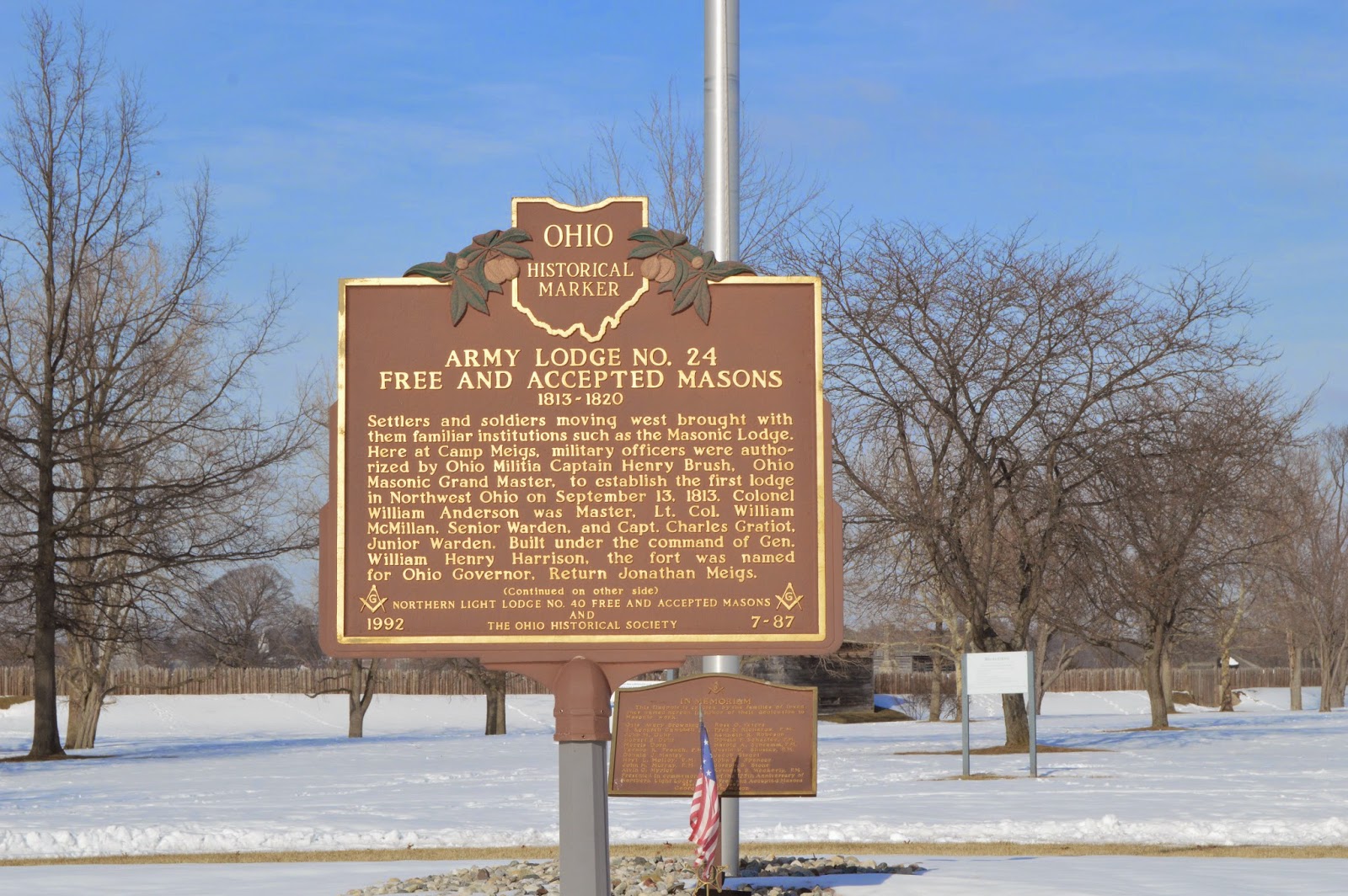
"ARMY LODGE NO. 24 FREE AND ACCEPTED MASONS 1813-1820

Settlers and soldiers moving west brought with them familiar institutions such as the Masonic Lodge. Here at Camp Meigs, military officers were authorized by Ohio Militia Captain Henry Brush, Ohio Masonic Grand Master, to establish the first lodge in Northwest Ohio on Spetember 3, 1813. Colonel William Anderson was Master. Lt. Col. William McMillan, Senior Warden, and Capt. Charles Graflot, Junior Warden. Built under the command of Gen. William Henry Harrison, the fort was named for Ohio Governor, Return Jonathan Meigs." (I did not tromp through the show to get a picture of the other side.)

"AMOS SPAFFORD

In 1810, some of the first American settlers in this area were Major Amos Spafford (1753-1818), his wife Olive (1756-1823), and their children Samuel, Aurora, Chloe (Mrs. Almon Gibbs), and Anna (Mrs. Richard Craw). In 1796, Spafford, a native of Connecticut, was a surveyor for the Connecticut Land Company He drew the first map detailing the layout of Cleveland and named the city. He left that area in 1810 following his appointment as custom's collector and postmaster for the new port at the foot of the Maumee River rapids called Port Miami of Lake Erie. Major Spafford was granted a 160 acre land patent on the River Tracts No. 64 and No. 65 in Waynesfield township, signed by President James Monroe and was able to purchase it following the 1817 Treaty of the Repids that extinguished Native American claim to the land. Two years later, sixty-seven families lived in the area, but most fled at the outbreak of the war of 1812."

 "17TH INFANTRY REGIMENT

The 17th Infantry, created by Congress in 1812 and formed with personnel from western states, was the only Regular Army regiment in General James Winchester's column of the Army of the Northwest's compaign to regain Detroit. During the war of 1812, the 17th fought at Frenchtown, Fort Meigs, Fort Stephenson, and Thames River. In 1815, the 17th was consolidated with the 5th, 19th, and 28th Infantry to form the 3rd Infantry. In May 1861, the 17th Infantry was again organized as a Regular Army regiment and has since served continuously with distinction.
The regiment served in Ohio at Columbus Barracks from `1894 until 1899, where, after the Spanish-American War, the American Veterans of Foreign Service, Philippine Insurrection, Mexican Border Campaign, World War II, Korean War, Vietnam War, and expeditions in Panama (1889-1990). The regiment was decorated with the Presidential Unit Citation for the Leyte Operation, The Philippine Presidential Unit Citation, and four Republic of Korea Presidential Unit Citations. Seventeen members of the 17th infantry have been awarded the Medal of Honor."