Sunday, January 10, 2016

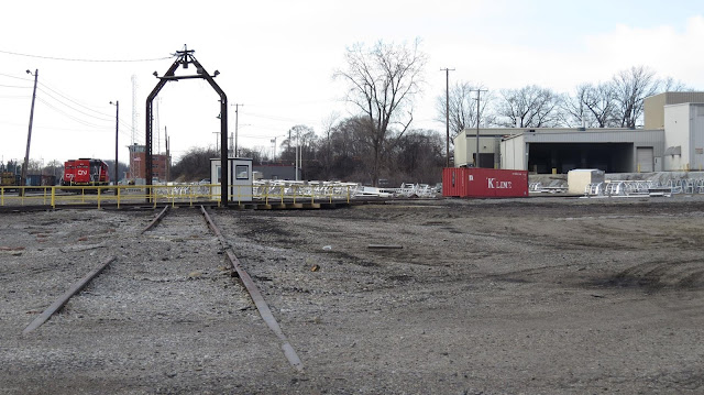
Boody, IL: Wood Grain Elevator and Abandoned B&O Route

If you are here because of "Northlake, IL: UP/CN&W's Proviso Roundhouse, Yard, and Freight House," they you need to go there.


Street View, Apr 2024

Street View, Dec 2018

Dick Bowman commented on a post: "We have a very similar elevator on the former Wabash RR, now NS, here in Boody, IL. It was erected about 1903."
Dennis DeBruler commented on Dick's comment

The railroad that went west of Boody was the B&O. That route is now abandoned.
1954/55 Niantic Quad @ 62,500

Google Maps has the wrong location for the Blackland label. It was haveway between Public Road and Zion Chapel Road rather than at Zion Chapel Road.
Satellite

There are still quite a few grain bins near the old B&O RoW.
Satellite

Did the B&O have trackage rights on the Wabash to connect to its branch east of Decatur?
1958/1971 Decatur Quad @ 250,000


Thursday, January 7, 2016

Pontiac, MI: CN/GTW Yard, Turntable, Coaling Tower and Depot

Yard: (Satellite)
Turntable: (Satellite)
Coaling Tower: (3D Satellite)
Depot: (Satellite, the topo map implies it was on the northeast side of the tracks.)

GTW used to enter Pontiac from five different directions. Only two of those directions still exist.

Tim Shanahan updated
Pontiac Michigan coal tower

This would have been the predecessor.
Jim Gilmore posted
Pontiac, Michigan coaling tower

James Price posted
Pontiac coal tower

Rick Shilling posted
1977 Grand Trunk Western Railroad Roundhouse, Turntable and Yard, Pontiac, Michigan.
 
Terry B. Carlson commented on Rick's post
1999 approximately 10 stalls were still covered by the RH. By 2002, it had all been demolished. The TT is still in use.
Google Earth Imagery Date: 6-8-2023
Location: 42.656214,-83.3180313

Charles Geletzke Jr. posted
This was the 10-stall-roundhouse at Pontiac, Michigan as it looked 54 years ago on August 13, 1962. Notice the "original" turntable operator's shanty, which was replaced in July 1967. Certainly a different era!
Todd Harrelson Looks the same as when I got there in 1977
David Cenci I spy one of the RS1's straight ahead..and an SW1200(RS) 3rd from left. Nice shot!

James Price posted
Matt Stiner: Do they use the turn table still [Mar 2025]?
James Price: Matt Stiner yes

Craig Hensley Photography posted three photos with the comment:
CN Pontiac Terminal 
I really enjoy capturing yard shots with the drone, and while out in the Pontiac area I had to grab a shot of CN yard. The aerial perspective really defines the track and switch layout, and also highlights the relics from the past. I find it fascinating that throughout all the years of modernization, the coaling tower still stands on the far side of the yard. You can also see the remnants of the roundhouse and the turntable that is still there as well. Even though this yard may not seem busy, but I'm sure there is still plenty of rail traffic that cruises through coming out of Detroit.
Tech: DJI Mavic Air 2s
Symbol: N/A
Engine/s: CN 5662 (EMD SD75I)
Date: 5/30/21 4pm
Location: CN Pontiac Terminal, Pontiac, Michigan
1

2

3

Richard Hueston -> Grand Trunk Western Historical Society

Brandon Mooney posted
GTW 4925 switches Pontiac yard on a misty morning.
Update: Pete Bloom posted two photos with the comment: "Where the roundhouse used to be. And where the long unused coaling tower still stands. Pontiac, Mi. Feb 2017."

1

2
Robert Werth posted two photos with the comment: "Here is the old coaling tower and the old roundhouse at the Grand Trunk Western yard in Pontiac, MI. I took these pictures in the late 1980's or the early 1990's....."
Chad Thompson Pontiac Coal Tower still stands. The roundhouse came down in 1996.

The compressor and drop table went to MSTRP (now Steam Railroading Institute). I believe that they in turn scrapped the compressor and sold/traded the drop table to another preservation entity.


There were patterns saved out of the pattern shop. Those since were sold by SRI to a private collector.

1

2
Ward J McGinnis commented on Robert's posting
Taken in 2013
William D G Baker commented on Robert's posting

Charles Geletzke Jr. posted
The GTW 5038 at the Pontiac, Michigan coal dock on March 25, 1960. (Roger J. Meade photo)
Greg Powell: That was the tallest smoke stack in Oakland county.

Robert Werth posted
I took this picture on a cold December day in the 1980's in Pontiac, MI.
Jeffrey Dobek Off to the right you can see some of the ex-PRR "Keystone" cars that SEMTA purchased, but never put into service. Some of these later ended up on the Coe Rail dinner train in Walled Lake, MI.
Jeffrey Dobek The cars on the left are a mix of ex-UP and ex-PRR cars that SEMTA used on the Detroit commuter trains.

Larry Burk posted
One more from Pontiac. The hill at Durant Ave was a good spot to railfan.
Note the passenger cars center left. When Blue Water Chapter used to have their stuff at the car shop in the yard.
Geri Climer Dunkle: Larry Burk is anything Bluewater still going?
Gabriel Wehner: Geri Climer Dunkle Dissolved in 2019, many cars from the chapters glory days are now in the hands of museums and private owners. Many went to Gary Southgate of Saskatchewan for his CN “Supercontinental” trainset.
Geri Climer Dunkle: ‘Twas grand riding to Port Huron, Cadillac, Fort Wayne and Bellevue… the last two with 611 for steam power❣️🚂
Tim Shanahan shared
Pontiac Michigan
Larry Burk posted
GTW Pontiac, MI yard.  July 1986.  The yard is to the right, looking down toward the engine facility with the roundhouse off to the left.   The passenger cars belong to an NRHS group that used Pontiac for storage.

One of nine photos posted by Terry Cummins.

One of nine photos posted by Terry Cummins.
Rodney D Zona The canopy over the diesel fuel pumps at the Pontiac yard. The building on the right was part of the old roundhouse.
Chad Thompson Roundhouse was razed in 1996.The drop table and air compressor went to Michigan State Trust for Railway Preservation (SRI).I believe the compressor was later scrapped and the drop table sold?
Terry Cummins What is a drop table?
Dennis DeBruler Terry Cummins It is in a pit under a locomotive in a Diesel Shop that facilitates replacing axle sets. Can you see these photos of the BNSF drop table in Galesburg, IL? They are in a private group.
https://www.facebook.com/groups/402599380076756/permalink/1010253219311366/

Chad Thompson Dennis DeBruler - they had them in roundhouses as well for steam locomotives.

Chad Thopson commented on terry's post
I have this ad in my collection, but it shows what was in a typical class I roundhouse.
[Note the ""CHANGE THOSE TIRES" description on the right side. ]


Eric Seitz posted three images of the coaling tower.

Depot


Charles Geletzke Jr. posted
GTW depot in Pontiac, Michigan.
Nick Stone: Where would have this been located?
Charles Geletzke Jr.: Nick Stone: Immediately railroad west of Huron Street.

1952/54 North Pontiac Quad @ 24,000

I got an aerial photo to confirm the topo map mark.
Jun 1, 1951 @ 23,600; AR1PN0000010157

Decatur, IL: Wabash Freight House

Kenny L Watson -> Follow the Flag Wabash Railroad
Kenny's comments:
This pic of the past, taken at the main street crossing in Danville Illinois, was posted by another member a while back. I just happened to be here and thought I'd get a present picture taken from about the same spot. Sorry it's not a day time pic.

That is taken from the north side of main street looking south . Tilton yard would be about 3 miles on west of here. 
Note the building on the right of the watchman's tower has the sign "Wabash Freight House." So we learn from this photo that the Wabash freight house was on the southeast corner of the Main Street crossing. Note the line of boxcars parked at the freight house.

That car must be from the 1930s because an aerial photo indicates that Main Street was grade separated by 1941.

1941 Aerial Photo from ILHAP

Update: The above was not the main freight house in town. 
History of the Heartland posted
1978 aerial of the Levee District area around the former Wabash stations.  At bottom right labelled "N&W Depot" is the former passenger station, no longer active at the time of the photo.  This building has been repurposed as the Wabash Antique Mall.
The long building running diagonally across the bottom of the photo is the former Wabash Freight Station.  The right side of the building held the administrative offices where less than carload freight shipments were managed.  The long extension to the left is the dock area where boxcars would be unloaded for transfer to trucks for the "last mile" to the final destination.  The Wabash freight office closed in 1963 when the railroad exited the less than carload business.  At the time of the photo it was used by Sol Tick & Company for scrap operations.  The building was later razed.
In the center of the photo the circular area still visible as an imprint in the earth is the location where the Wabash roundhouse had stood for 97 years between 1856 and 1953.  The track stalls so deeply impacted the earth that even today the ruts are visible. By 1978 the turntable, which survived the razing of the roundhouse in 1953, had also been removed.
Three Class I railroads were still very active at the location at this time:  The Norfolk & Western operated over the former Wabash trackage running east-west (top to bottom); the Illinois Central Gulf ran north-south (left-right) on trackage that dated back to the very beginning of that railroad; the Baltimore & Ohio yard on the right side of the photo connected to tracks running east along Eldorado and then Route 36 out of Decatur, linking to Indianapolis and the east coast.
Photo: H&R
Terry Howley: B&O yards are to the right center of this photo , Southeast of WABIC tower , along with their turn-table which is still standing just west of the Jasper st underpass . Amtrak used the N&W depot from July 1, 1981 until July 10, 1983 when service to Decatur ended
Richard Fiedler: Adam White actually 5 class one railroads operated there then: The N&W, B&O, Illinois Central, Illinois Terminal (via trackage rights on the N&W), and Penn Central (former Pennsylvania RR via IC trackage rights)..
Leonard Perlmutter shared
Looks like that old dinner that Sol Tick scrapped there at the old frieght station is there. I remember the folks at Monticello wanted acesss to it, but don't know if it ever happened.
History of the Heartland: Richard Fiedler this is partially correct. By the time of the photo the Penn Central had sold their Terre Haute to Decatur line to the Wabash Valley shortline. Their successor Conrail sold the Peoria to Maroa section (north of here) to the Illinois Terminal soon after.
Nick Fitzgerald: Do you happen to have an easy to read map of the tracks entering and leaving the Dearborn Station in Chicago.
Dennis DeBruler: Nick Fitzgerald I just uploaded C&EI1964ChicagoDearborn-300lg.pdf to the files section of this group.


Tuesday, January 5, 2016

Jonesboro IL: M&O Depot

Bart Hileman posted
Unlike the open freight platform in Alto Pass, the depot in Jonesboro has a standard closed freight handling area even though it is further south on the M&O route.

The picture in the comment indicates that it has been saved as the town's library.

Bart Hileman commented

Aaron Qualls posted
Ex-IC “Side Door” caboose no. 9765, in Jonesboro.

Aaron Qualls posted
The GM&O’s depot in Jonesboro, now the town’s public library.


Alto Pass, IL: M&O Depot

Bart Hileman posted
This is the first time I have seen an open freight handling platform. The horse&buggy and train order signals indicate it was taken in the early 20th century. A current map indicates the town no longer has train service. In my 1928 RR Atlas, the route is marked M&O (Mobile and Ohio?). This reminded me that the GM&O route between St. Louis and Chicago is marked Alton. So GM&O was formed from Chicago & Alton and M&O after 1928.

Wauseon, OH: NS/NYC/LS&MS Depot

The Wabash was a few blocks north where Dickman Road is now. The DT&I was closer to the depot. 1943 Wauseon Quad @ 62,500
Jim Etchie -> Railroad Depots, Shops & Structures of North America
(Satellite, 25 photos)

Hopefully, this is a permanent link, because this was one of several pictures of the Lake Shore & Michigan Southern depot, most of which were interior shots.
Sheldon Nicholas Photography posted
The station at Wauseon, Ohio
Art LH shared
Colin Harding: According to my 1940 Official Guide on both the Wabash & NYC.

Dennis DeBruler commented on Colin's comment
The Wabash was a few blocks north where Dickman Road is now. The DT&I was closer to the depot. 1943 Wauseon Quad @ 62,500

Street View, Oct 2013


Friday, January 1, 2016

Freeport, IL: East Tower: IC vs. IC

Jim Datt -> Illinois Central Railroad Heritage Association
Either the Hawkeyes or Land o Corn at east junction in Freeport, and don't know when it was taken, as I was not the photographer. Sorry about the quality. I had to take a picture of a picture.
Jim French: This is great Jim. Only shot I've ever seen of East Jct Tower." Michael Ferris observed: "Looking at the details on the E unit I'd say somewhere between 1960-63.

A problem with following railroad specific Facebook groups is that they take for granted that all of the members of the group would know the details such as where the "East Tower" was. I'm assuming it is where IC's new route from Chicago to Freeport joined the original "Charter Route" up the middle of the state to Freeport that then turned west to Galena. (As I have mentioned before, in the mid 1800s, the river town of Galena was considered to be more important than the swamp town of Chicago. But, of course, Chicago became more important, and IC then felt a need for a route directly from Chicago to Freeport.)

1938 Aerial Photo from ILHAP
The resolution of the 1938 aerial photos is not good enough to see tracks and ties, so it is sometimes hard to distinguish between a freshly ballasted railroad and a concrete road. I know the line coming in at an angle on the right is the new line built from Chicago because it still exists on contemporary maps. I can tell the line coming up on the right side of the picture to join it was the charter line because it changes from black (a train) to white (just the RoW). The line cuming up from the middle of the bottom is the Milwaukee Road. It appears to go under the IC tracks. That is, there is no junction between the IC and the Milwaukee.

The black rectangle in the upper-left corner of the following would be the shadow of the tower. The tower itself is a barely grey blob.

1938 Aerial Photo from ILHAP