Wednesday, March 2, 2016

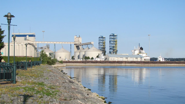
Sorel QC, Canada: Seaway-Max to Ocean Going Grain Transloading and Tim S. Dool Freighter

(Satellite)

This may be the largest, active grain elevator that does not have rail service. I'll let Dave explain:
Dave Hickcox posted two photos with the comment: "Sorel, Q.uebec.  This elevator is at the confluence of the Richelieu River and St. Lawrence River several miles downstream from Montreal.  The elevator is very active as Great Lakes ships bring grain down from the Canadian prairies and unload. The elevator then will load salt water ships for export. The second photo shows a Great Lakes ship unloading and you can also see the setern section of a salt water ship loading.  Aug 6, 2014"
1

2
[A superstructure on the bow of the unloading ship means that this is an old ship.]

I saved this satellite image because it shows the elevator simultaneously unloading a small ship and loading a big ship. The shadows highlight the two mobile towers that hold the unloader legs.
Satellite

Here is a closeup of one of those marine towers.
Julien Lemay posted
Sunset on the Tim S. Dool
St-Lawrence River
Sorel's Grain Elevator
7-12-21
Dennis DeBruler
Julien Lemay That is the best shot I have seen of a marine unloader leg. I've learned that in 1967 the Tim S. Dool was the second Great Lakes bulk carrier built with all of the superstructure on the stern and that in 1996 3' was added to the width of the ship.

Most Great Lakes freighters have converted to self-unloading so I was surprised to see modern marine towers. Richardson not only owns this elevator, its owns a big facility in Thunder Bay. I think it owns its own fleet of three ships that includes the Tim S. Dool. They must have decided that it was cheaper to upgrade their marine towers than to convert their ships to self-unloaders.

Note the crane hook coming down in this photo. This confirms that they will lift the loader into the ship's hull so that it can push the grain into piles that the unloader can remove.
Sam Brouillard, Dec 2018


Michael Hull posted, Jan 3, 2022 at Thunder Bay Heddle Shipyard
[I wonder if this is the layup for the Winter. The Welland Canal closed about a week before the Soo Locks closed on Jan 15, 2022. Richardson's Thunder Bay grain elevators are in the background.]

Another ship with a superstructure on the bow being unloaded.
Gary Waters posted
Ojibway, Sorel...


Tuesday, March 1, 2016

Hennepin, IL: Marquis Energy Ethanol Plant

At least some ethanol plants are still working in this time of low gas prices. It probably helps that we have had bumper crops of corn and the cost of corn is also low. Robert Jordan caught these pictures on 2/17/2016 on the Kankakee Belt.

Robert Jordan posted
Robert Jordan posted

Satellite
Mark Baker posted two photos with the comment:
May 14 at 11:21 AMMarquis Energy at Hennepin, Illinois. Along the dark silhouette of mostly black tank cars during an overcast period on May 13, 2019 was the outline of a switching locomotive. Cropped image from a telephoto shot shows the Marquis corporate logo and what appears to be reporting marks; MVPX 1791 (?). Curious about the specifics of this unit. Anyone have further info? Of course, this and a few other industries are served by the NS at the West end of what was the NYC's "Kankakee Belt".
Alex Moon Former SP SW1500, but with the trucks swapped. Neat find!
1
Marquis Energy at Hennepin, Illinois. Along the dark silhouette of mostly black tank cars during an overcast period on May 13, 2019 was the outline of a switching locomotive.

2
Cropped image from a telephoto shot shows the Marquis corporate logo and what appears to be reporting marks; MVPX 1791 (?). Curious about the specifics of this unit. Anyone have further info? Of course, this and a few other industries are served by the NS at the West end of what was the NYC's "Kankakee Belt".

Chicago, IL: Snow Plow Horses

I'm surprised to see a car in 1908. Most pictures of train depots in the early 1910s don't have cars. And this is even earlier. You can see Central Station in the background above the car.

Laura lara-Huy shared Pasqual LoPresti's photo

Michigan City, IN: 1923 Amtrak+NS/NYC/Michigan Central Coaling Tower

(3D Satellite)

Most railfans see a train. I see a coaling tower.
Steven J. Brown posted
Amtrak Wolverine #353 at Michigan City, Indiana - May 8, 2019.

Joseph Tuch Santucci posted
Joseph's comment:
In the 1990's Amtrak's International, operated jointly with Canada's VIA Rail used to frequently mix and match power and train sets. In the summer of 1995 I caught the eastward International with VIA F40PH-2 6449 leading a consist of Amfleet (Budd built) coaches through the old coal tower in Michigan City, IN.
Charles Kevin Zak We supplied the coaches and they supplied the power thru the 90's until the end of the international service.

Rick Novasky Charles Kevin Zak, I can't remember why they switched over from VIA cars(might have been a shortage of some kind) to Amtrak. When I started working those trains it was Amtrak cars VIA power. Then went to all Amtrak consist when they started the high speed rail crap between Kalamazoo and Porter. VIA didn't have the engines to dedicate to U.S. service.

Matt Lasayko posted a couple of photos with the comment:
Out picking today and stopped to take some pictures on the old Michigan Central, Coaling tower before it gets torn down, it's not slated to come me down but you never know. It's located just outside Michigan City IN on the east side on rt12

1
2

Mark Hinsdale posted
Dogging an NS Decatur (MI) grain train on the mostly passenger artery in southwestern Michigan and northwestern Indiana.Glen Warmann Lone the consecutive GP60's at both ends, and the KCS is bonus!!!Herb Theodore Those GP60s are ITCS equipped and have to lead on both endsHarold J. Krewer Incremental Train Control System = ITCS.Walt Del Calle Amtrak's Midwest version of PTC. Also used CHI-STL
Steven J. Brown posted
Amtrak Blue Water #365 passes under the Michigan Central Coaling Tower in Michigan City, Indiana - February 27, 2017.
Stuart B. Slaymaker For years, the east side of the coaling tower had "Long Live Fidel Castro" scrawled on it. I think the wind and weather, finally wore it off!
Algis Oslapas posted
Michigan City, Indiana, along US12. Abandoned Michigan Central coaling tower. Amtrak #351 passing underneath. Sept 22, 2018

TheBeacher via Greg Burnet post
 
Joseph Tuch Santucci posted
Two iconic landmarks, both destined for elimination. Up front we have the former Michigan Central coal tower located along what is now Amtrak’s Niles subdivision on the northeast side of Michigan City, IN. If you look through the opening you can see the cooling tower from NIPSCO’s Michigan City Generating Plant. This coal fired power plant is slated to be decommissioned in 2028.
8 October 2023

Arturo Gross Flickr 2018 Photo, two Amtrak engines running light.

Four photos taken from the road with the comment: "????"
Dave Kuntz: Interesting to note that the last generation of steam locomotives built were expected to be retired in the 2020s, and the infrastructure surrounding them was also obviously built to last until now too.

Nov 26, 2024:
safe_label for Amtrak planning to tear down Michigan City, Ind., coaling tower
Passengers for eight daily Amtrak trains will be bussed between Chicago and New Buffalo for two weeks during the deconstruction of the tower in 2025.

Steven J. Brown posted
Amtrak Wolverine #352 at the soon to be demolished Michigan Central coaling tower in Michigan City, Indiana - May 10, 2025.

Kankakee, IL: Steam Driver Wheel Lathe

Dale Burkhalter posted
Dale's comment:
Frank Leroy "Happy" Burkhalter, machinist, at wheel lathe, Chicago, Indiana and Southern Railroad (Kankakee Line) engine shop at Kankakee, Illinois. My grandfather. Later became Round House Foreman at Kankakee.
Justin Gillespie Where in Kankakee was this shop/roundhouse?

Dale Burkhalter The Three I had a roundhouse Between Entrance Ave. and the Illinois Central tracks. The Big 4 roundhouse was on North Greenwood Ave. The Big 4 roundhouse was used by the New York Central. Not sure if the shop was near either one. At the time this picture was taken, Frank worked for the Chicago, Indiana and Southern, a railroad that was before the New York Central took over.

"Three I" is the Indiana, Illinois, &  Iowa, and it was part of the corporate linage of the CI&S, Kankakee Belt, and NYC.

Update: see several more wheel lathes.

New Haven, IN: NE Tower: NS/Wabash vs. NS/NKP and Depot

NE Tower: (Satellite, lots of changes since this photo was taken)
Combination Depot: (3D Satellite)

James Holzmeier shared a Flickr Photo, cropped
New Haven, Indiana on the Wabash Railroad. Just east of Ft. Wayne. The Nickel Plate RR crosses from left-to-right in this John Barriger photo. Going straight would take you to Toledo, while curving off to the left ("railroad east") is the line to Detroit. The track alignment here was changed in 1944-1945 to ease the curve from 5 degrees as shown here, to a more manageable 1 degree curve. The cost of the line relocation was shared between the two railroad companies; the Wabash's share was 145,000 dollars. With the line relocation project finished, it upped the train speeds from 15mph (both freight & passenger) up to 50mph for freights, and 55mph for passenger trains.
The wood combination depot at New Haven has now been restored.
[Note the grain elevator in the background.]

James commented on his post
Wabash RR map

Tim Shanahan posted
New Haven IN.

I used this topo map as a base to add the old alignment because it shows how the Wabash and NKP paralleled each other through town. The map is not quite accurate because I think the east/west yellow line should be level instead of going a bit north as it went east. The rectangle shows the location of the tower in Barriger 's photo because he was on the old alignment.
1956 Fort Wayne East Quadrangle @ 1:24,000 plus Paint
The connecting tracks have been replaced by connections right at the junction and only one track is now used through town. The Wabash and NKP routes now separate on the east side of town. This 1998 topo still shows a double track through town. But a 1998 Google Earth shows just a single track. So I looked at historic aerials. 1962 shows double tracks, but the next image, 1981, shows just a single track. That makes sense since both the NKP and Wabash were merged into the N&W in 1964. So the 1972 and 1981, as well as the 1998, topos are wrong.
1998 Fort Wayne East Quadrangle @ 1:24,000


The depot has been nicely restored.
Xikang Zhao, Nov 2018, cropped
It was a relatively recent restoration. And much needed. Fortunately, it never did loose its freight door opening and gingerbread.
Street View, 2011

Tremont, IL: Lost/NYC/Big Four/Peoria & Eastern Depot

If you are here because of "Lafayette, IN: Monon Roundhouse," then you need to go there.

(Satellite)

Connor Bounds posted
Here's the Tremont depot today, now home to a coffee shop also a large addition that I tried to keep out of frame.
Paul Tincher: Peoria & Eastern
Alexander Golman: Eli's Coffee Shop. Best in Central Illinois.
Richard Fiedler shared
lll
Street View, Jun 2023

1932/32 Mackinaw Quad @ 62,500

1939 Aerial Photo from ILHAP

Digitally Zoomed