Saturday, July 9, 2016

Delavan, IL: Historic Postcard, Junction and IC & GM&O Depots

These locations are guesses based on the depot photos and the aerial photo.
IC Old: (Satellite)
IC, 1928: (Satellite, the land is now part of a storage unit.)
GM&O Old: (Satellite)
GM&O New: (Satellite)

Note the old grain elevator on the right side of the photo.
Roger Kujawa posted
Found this old Post Card of Delavan at the flea market.

CN/IC still goes through town. ICG abandoned the Chicago & Alton route. A connector from the IC to the C&A is now an industrial lead for an elevator that was along the C&A.

The IC was the east/westish route whereas the C&A ran north/south through town.
1939 Aerial Photo from ILHAP

Update:
John Woodrow posted
ICG (Peoria district) crossing GM&O (Jack line) Delavan Illinois about 1973 (Wayne Bridges photo)
Bill Edrington: Thanks for sharing this. GM&O #1520 is stopped at the westbound home signal on the “Jack Line“. (Actually it was also an ICG unit by this time.)

Dennis DeBruler commented on John's post
The building in the northwest quadrant with the bay window must have been GM&O's depot. It is consistent with the L-shaped building in this 1939 photo.

Dennis DeBruler commented on John's post
Page 55 in https://libsysdigi.library.illinois.edu/.../delavanbicent...

1942/49 Delavan Quad @ 62,500

Andy Zukowski posted
The Illinois Central Railroad and the Chicago and Alton Railroad Depot’s in Delavan, Illinois. C.1910
Photo by C.R. Child’s
William Shapotkin: Just for the heck of it, which depot is for which railroad?
Richard Fiedler shared

Dennis DeBruler commented on William's comment
Because of the grain elevator in the background, GM&O is on the right and IC is on the left. IC built a new depot in 1928, and I think the GM&O built a new L-shaped depot on the old IC property by the date of this aerial photo, which is 1939. https://www.facebook.com/groups/ILLRRHISTORYBUFFS/posts/3702937163265756/ (GM&O is the north/south route with lots of tracks and IC is the east/west route with just one track.)
Bill Edrington: The L-shaped replacement depot at the crossing of the Alton/GM&O and the IC was jointly used by both roads, and was staffed by a joint agent. It was equipped with train order boards for both roads. To the best of my knowledge, the building visible along the Alton tracks just north of the joint depot in the aerial photo is the old C&A/Alton depot, which was torn down at some point.

Dennis DeBruler commented on Bill's comment
Thanks for the correction. I thought that the L-shaped building looked like a joint depot. I was confused by this caption about an IC station that was used until 1969. Maybe it was used as the freight station. The source is https://libsysdigi.library.illinois.edu/.../delavanbicent..., page 55.

Friday, July 8, 2016

Kenney, IL: IC Tower: IC vs. Pennsy

Gary Sams posted
Kenney, Illinois I C Tower
Rick F This would be the crossing of the Pennsy to Peoria and the IC lines between Chicago and St. Louis,
Larry Quick I think it's a Pennsylvania sb.
You can clearly see where the Pennsy went through town.

Satellite plus Paint
1941 Aerial Map from ILHAP

Chicago, IL: 1933-95 Wrigley Gum Factory and 1924 Wrigley Headquarters

Factory: (Satellite)


Dorothy Stutzke shared Chicago History's photo.
The Wrigley Factory, 3535 S. Ashland, 1933...Chicago. Closed in 1995.
Patty Lawson shared
Chicago Mecca Of Murder posted

Growoing up in Chicago posted
1933 - The Wrigley Factory, 3535 S. Ashland. Closed in 1995.
Marti L. Foster: My Mom worked there from 1970 to 1987, she loved that place, said it was the best job she ever had. Sadly it is now an Amazon warehouse.

Thomas Mitchell posted
The Wrigley's chewing gum factory located at 3535 South Ashland was built in 1911 and remained open until 2006. Demolition began in 2013 and was completed in 2020.
Harlo Montana: snuck in there in 2017 or so. they had left a lot of the raw gum making ingredients in the building when it was abandoned - the floors were STICKY in some places and I nearly left the soles of my worn out shoes behind a few times 😂 the smell on a hot day was not super pleasant either. was very sad to see it replaced by a soulless amazon building.

Once again, I have to use the older images in the birds-eye view because the buildings have been torn down. The plant was closed in 2006 and torn down after it was sold in Feburary, 2012. (curbed) (An update I added below indicates the building was closed in 1995.) And they are not even making a parking lot! So the Central Manufacturing District has lost another set of buildings and the city has lot more of its tax base.

Kevin Piper posted a history and several images.

The offices have moved to the Wrigley Global Innovation Center and manufacturing has moved to Yorkville. There was enough land in the city they could have built a modern factory there and have room to expand if they built a parking garage. But you don't need as much parking in the city because there is some public transportation. I'll bet there is no public transportation in Yorkville. So not only are employees forced to move, some may have to buy a car. Is the new plant more automated and they wanted most of the employees to quit in disgust? That might save them severance pay. Also, good luck getting the brains in the office complex to go to the plant to figure out how to fix manufacturing problems. Especially the plant in Atlanta, Georgia.

The following two images are at the same scale. Also, the poor truck drivers have to drive a ways on IL-47 before they can get to an Interstate road. The city plant was a few blocks down the road from an I-55 exit that quickly connects with interstates to all points of the compass. (The new site is next to a railroad, but they are not using it. The old site did have rail service, but I doubt if they were still using it.)

Satellite
Satellite
Update:
HansJager via Google via Facebook
Don Mac I believe they just [Jan 2020] finished tearing this building down.
[The HansJager link is worth clicking. He has info and photos concerning these buildings, the Central Manufacturing District and Chicago corruption.]

I read that Wrigley has been sold to Mars and that they are adding a Skittles plant to the Yorkville facility. So maybe they do need a lot of land to grow. And the trucks may just go to one of the several logistics companies that have been built in the Bolingbrook area and those companies handle the deliveries to the stores across the nation and the world.

Bird's Eye View

A Chicago Tribune article by Samantha Bomkamp describes the Skittles expansion. Unfortunately, the article I tore out of the paper does not include the date. A $50 million plant expansion was sweetened by $3 million state and local incentives, mostly state. Demand has grown so the Yorkville production will augment what is currently made in Waco, TX.The 145,000 sq ft expansion will support the growth of the top-selling nonchocolate candy in the U.S. The new production line adds 75 workers to the 300 already at the plant making gum and mints such as Juicy Fruit, Doublement and Life Savers. Comparing the bing image below to the Google image above, the new line must be the new building on the east side of the facility.

Bing Satellite
Edward Kwiatkowski posted three photos with the comment: "Demolition of the Wrigley's Chewing Gum factory on South Ashland Avenue and West 35th Street, in Chicago's Bridgeport neighborhood. Chicago Illinois. May 2020."
Ted Gregory shared
1

2

3


Headquarters


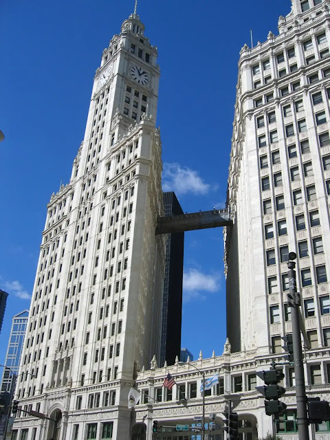
And his famous headquarters. It is hard to appreciate how much guts it took to build on the north side of the river after the Michigan Avenue Bridge just opened until you see photos like this one. Michigan was not the "Magnificent Mile" back then. In fact, even by 1963 when Marina City was built, it was considered risky to do a major development on the north side of the river.
Daniel Bovino posted
In this 1922 aerial of Chicago, the tallest building is the Wrigley. The Tribune Tower was not yet built. Rush Street had a small bridge behind the Wrigley building that spanned the Chicago River. In the foreground are train sheds. They were located at the IC's Mile Post 0. This represented the beginning of the Illinois Central railroad.
Paul Webb shared
 
Janet Morrow posted
Wrigley building in 1922. It was amazing in it's day.

Eric J. Nordstrom posted
photographic image (scanned from original glass negative) of  graham, anderson, probst & white's 30-story wrigley building (south tower) as it appeared on august 22, 1922.
the image was taken by or for the great lakes dredge and dock company.
courtesy of the bldg. 51 archive.
David Daruszka: Smoky Chicago air.
 
I grew up in Illinois posted
The Wrigley Building, a dazzling white structure gracing the Chicago skyline, is more than just a beautiful building; it's a symbol of the city's rich architectural heritage.
Conceived by chewing gum magnate William Wrigley Jr., the building was erected between 1920 and 1924 as the headquarters for his company. Its distinctive twin towers, clad in shimmering white terra-cotta, were designed by the architectural firm Graham, Anderson, Probst & White, drawing inspiration from the Giralda Tower in Seville, Spain.
As the first major commercial building north of the Chicago River, the Wrigley Building played a pivotal role in transforming Michigan Avenue into the iconic Magnificent Mile. Its elegant design and prominent location quickly established it as a landmark, captivating the eyes of locals and visitors alike.
Today, the Wrigley Building remains a cherished symbol of Chicago's architectural prowess and a testament to the vision of a man who wanted to create a building as radiant as his successful business.
Architectural details:
 * The Wrigley Building's facade is adorned with intricate limestone ornamentation, featuring gargoyles, grotesques, and other decorative elements.
 * The building's crown is a masterpiece of terra-cotta craftsmanship, featuring a clock tower and four smaller towers topped with copper roofs.
 * The lobby boasts a grand staircase and a magnificent stained-glass ceiling, showcasing the Art Deco style popular during the building's construction.
The Wrigley family legacy:
 * William Wrigley Jr.'s wife, Dorothy, played a significant role in shaping the building's design. She insisted on the use of white terra-cotta, giving the building its distinctive and elegant look.
 * The Wrigley family maintained ownership of the building for over 90 years, ensuring its meticulous preservation.
Interesting facts:
 * The Wrigley Building was briefly the tallest building in Chicago until the Tribune Tower surpassed it in 1925.
 * The building's floodlights were originally used to promote Wrigley's gum but now illuminate the Chicago skyline at night, creating a breathtaking spectacle.

Windy City Historians posted
1930s original photograph of downtown chicago (looking southwest) from howells and hood's tribune tower (1925). the wrigley building (1921) is in foreground below.
courtesy of bldg. 51 archive.
 
architecture
It was completed in 1924.
"Such a prominent site demanded a notable building, and architects Graham, Anderson, Probst & White delivered. Modern in its height and steel-frame construction, the Wrigley Building's facade nonetheless bears the weight of history. When Wrigley was just starting his chewing gum company he debuted Juicy Fruit gum at the 1893 World’s Fair, and he never forgot the famed White City or its nighttime light displays. Those memories live on in his namesake building. Six different shades of gleaming white terra cotta become brighter as the building rises, and its facade is illuminated at night."

Raymond Kunst posted
Construction of the Wrigley building on the Chicago River (1920-1924).
The old Rush street bridge in the foreground.
[There are some comments about the pollution.]

[The photo above this one has better resolution.]
Historic Chicago posted
Wrigley Building and the Rush Street Bridge (1921)
The Rush Street Bridge is the open swing bridge in the middle of the river. It would be permanately open until it was removed because it has been replaced by the Michigan Avenue Bridge behind it.
US City Views posted
Wrigley Building and the Rush Street Bridge Chicago (1921)
In 1921, the Wrigley Building, newly completed, became an iconic addition to Chicago’s skyline. Its gleaming white facade, inspired by Spanish Colonial Revival architecture, and its prominent clock tower made it an instant landmark. The building’s location near the Rush Street Bridge, which spanned the Chicago River, highlighted its significance as a gateway to the city’s bustling commercial district. The bridge itself was a vital link between the north and south sides of the city, facilitating the flow of people and goods. Together, the Wrigley Building and the Rush Street Bridge symbolized Chicago’s architectural innovation and its role as a center of commerce and industry in the early 20th century.

Kevin R Doerksen commented on the above Historic Chicago post.
A view from overhead from 1920

Glen Miller posted
The Wrigley building under construction in 1921. The building is clad in more than 250,000 glazed terra-cotta tiles produced by the Northwestern Terra Cotta Company. You may not have noticed, but there are six shades of white on the building. Brighter shades are near the top to contrast with the blue sky. Also the building has been lit up at night since it's completion. There are lights on Wacker, lower Wacker, lights across the street and even a few lights on neighboring buildings all illuminating the building at night. They recently upgraded the fixtures and they increased the number from 100 lights to 300. They still saved almost 70% on the lighting bill by switching to led.
Stephen Augle posted
[The description is a subset of the above text.]

MWRD posted
A view of a boat docked on the Chicago River near the Wrigley Building, looking northwest from the DuSable Bridge on Michigan Avenue on September 14, 1926.


Thursday, July 7, 2016

Chicago, IL: Fairbanks, Morse & Co.

Streetview from Wabash
I assume that at one time this building was the headquarters of Fairbanks-Morse. I learned of this building from Fred Bowman's posting. I have postings of a F-M generator set, locomotives, and coaling towers. I could not find the video where they run a 4-cylinder 1936 Model 32D like a musical instrument, so I include it here. (When it runs slow, you can see holes in the outside edge of the flywheel. That is where they stick in a bar to turn it to get it in the right position to start: examples 1 and 2.)

Streetview from corner of 9th and Wabash

Zoomed into the Wabash side of the building.

Frankfort, IN: Railroad Hub

Doug Ingersoll posted
I knew the east/west route through Frankfort was NS/NKP, but when I looked at a railroad atlas to determine the north/south route, I was surprised to find that there used to be two north/south routes --- Monon and Pennsy. Furthermore, the NKP route through town carried both the Cloverleaf and the Lake Erie & Western parts of NKP.
Larry Wojcik commented
2016, that awesome signal still
doing its job!
Even INDOT's map (below) is wrong because it does not include a Pennsy route to the southwest. I have added that line plus labels indicating who owns or who abandoned each spoke and who owned the railroad in 1928. The "*" is a Pennsy route that is now (as of 2005) operated by CSX and CIND. CIND was Central Railroad of Indiana, which is a RailAmerica subsidiary operated by Indiana & Ohio Railway.

INDOT
Pennsy north of Frankfort was abandoned by Conrail, but according to a satellite image, the track through town is still intact. There are no industries along that track, so why are all of those road crossings and the diamond still maintained? The reason is probably because the interchange track between NS and CSX is in the northwest quadrant of the junction. Also note that NKP/CL extends west to here to serve several industries on the west side of the town. I saw covered hoppers spotted at two of the industries, so I don't think that Cloverleaf remnant is currently abandoned as indicated by the INDOT map.

To the satellite image below, I added a blue line to indicate where the former PC/PRR route was and a red line to indicate how Monon ran through town. I found a 1980 topo map on historicaerials.com to confirm the Monon did street running up 5th Street.

Satellite plus Paint
Update:
Carl Venzke posted
Nickel Plate engine 720 is crossing the Pennsy’s Indianapolis to Logansport line at Frankfort, Indiana on August 11, 1954. In a few hours the train will be pulling into Lima, Ohio. There is nothing remarkable about this picture except you gotta love that tower. Photo courtesy of the Nickel Plate Road Historical & Technical Society

Dennis DeBruler posted
Brian Knight posted with the comment: "Back in the days when we got on and off the caboose on the fly. Frankfort Indiana probably late 80's."
Jim McLinn
I remember in conductors school, if you couldn't get off and on moving equipment, you were let go right away. That was the first few days of school,and they taught you the right way and the wrong way, but if you couldn't do right, you were out of there.
Now days they fire you if you do get off when it's not at a complete stop. Crazy stuff at times.
Walter Borys
Long but fascinating Training video (1972) on right and wrong ways to mount a train


Wednesday, July 6, 2016

Baldwin, MI: C&O/PM Coaling Tower and Depot

C&O Railway Pere Marquette District Page 
posted
Pere Marquette used to have both the north/south and east/west routes through Baldwin, MI. CSX still operates the western and southern spokes.

Tower: (Satellite)
Depot, Actual: (Satellite)
Depot, Labelled: (Satellite)
Nick Christian commented on the posting
Winter time

Kathy Sova posted
Baldwin Mi. Not sure what it was used for.
[A comment thread talks about an abandoned marl plant near Marlborogh, MI.
Several comments list other coaling towers.]
Tim Shanahan shared

Sean Attenberry commented on Kathy's post
Back when it was still being used.

1 of 4 photos posted by Corbin Dickerson
Old C&O coaling tower in Baldwin MI.
The line forking west is still in operation by the Marquette Rail Co.
North and East are long gone.
Charlie Ake: Is the depot still there?
Corbin Dickerson: Charlie Ake yes
Christopher Love shared
Tim Shanahan shared

Scott Scramlin, Jun 2021

Noah Haggerty posted
The former Pere Marquette depot located in Baldwin, Michigan on July 10, 2025, now under ownership by Marquette Rail. Once CSX took over, it was fixed it up for MOW/storage use, and now MQT uses it as a crew base.

Nathan Nietering commented on Noah's post
The last passenger trains stopped at Baldwin on the Grand Rapids-Manistee-Petoskey line at the end of October, 1966. It’s great the depot building remains and still has a use!

Edward Gross, Oct 2003