Friday, July 10, 2020

Fairport Harbor, OH: B&O Coal Loader, USS Ore Unloading and Salt Loading

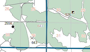
(Satellite, it was on the southern shore of the northern slip)

Between iron ore coming in and coal going out, there were a lot of rail/water transfer facilities along the south shore of Lake Erie.

Now this port ships salt. (An article with 12 salt mining photos. An article with 9 photos (pay count). Morton Salt ships about a million tons a year, half of which uses lake shipping. [USACE])

Bob Weston posted
Baltimore and Ohio Railroad’s Fairport, Ohio coal loader. This loader was closed in 1965 when the B&O made an arrangement with the Bessemer and Lake Erie Railroad to move coal through their Conneaut, Ohio, facilities. Julian W Barnard photo 2 July 1966. R J Weston collection.
Dale Pohto Hard to believe that there were kids who were brave enough to jump into the slip from atop this loader!
B Tupper Upham I spy a Pringle barge stack...
Dale Pohto And the aft half of a G-tug in the foreground under it...
Fred Bultman Fairport was winter maintenance facility for Columbia, who operated the Pringle barges.
Dale Pohto I'm very familiar with the Fairport Machine Shop... Most (but not all) of Oglebay Norton's crane ship conversions were also performed there. Aside from the slips, no trace of any of these facilities remain.

Bob Weston posted

Another view of the B&O RR coal dumper at Fairport Harbor, Ohio, on 2 July 1966. The dumper was no longer being used but a shipping company was using the dock. Julian W Barnard photo. R J Weston collection.

Fred Bultman Was this where Columbia operated their winter repair facility?

Bob WestonAuthor yes

Dale Pohto Fred Bultman The Fairport Machine Shop (on the left) was where most (but not all) of Columbia's crane ships were converted. Other than the slips, no trace remains of any of these facilities.

Jon S. Chapin and I recall 2 dock/slips, were there 2 dumpers, once?

Dale Pohto Jon S. Chapin No, two slips but only one loader. The non-coal slip was for boats undergoing work by the machine shop. That slip has since been allowed to slowly fill in so as to be almost unrecognizable now.


Photos of a self-unloading Pringle barge being loaded: 1 and 2. These photos may have been taken in Conneaut, which had a similar loader. (Pringle Barge seems to be the company owning the barges, not a design style.)
1953 Mentor Quadrangle @ 1:24,000

USACE 1960 Report
Historical aerials, especially 1970, show that the loader was on the south side of the northern slip. It was gone by 1982.

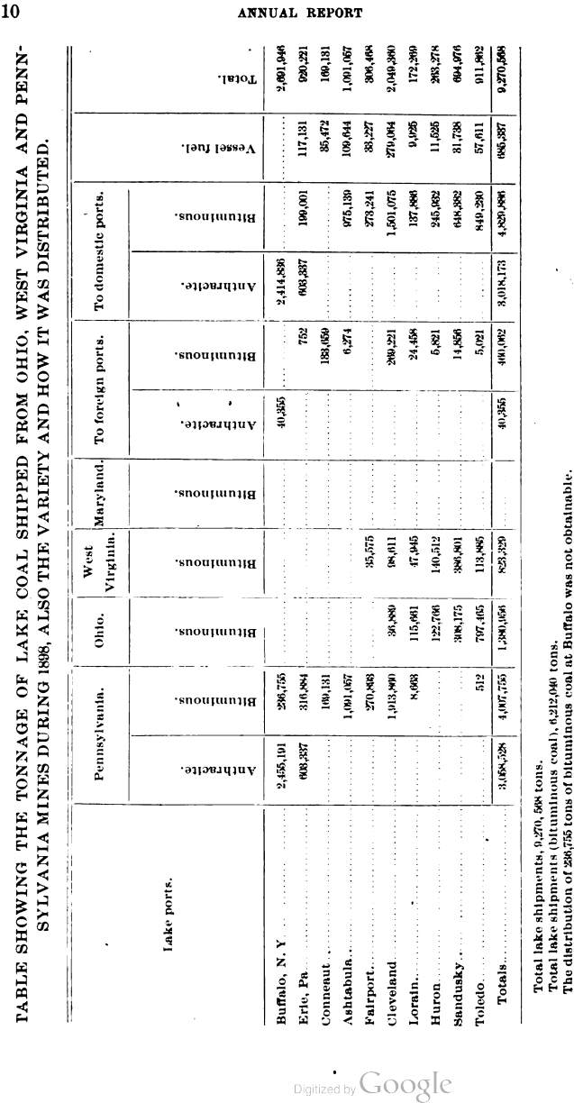
Both Fairport and Conneaut were smaller players in terms of tonnage shipped.
1898 Mine Inspector Report @ 153%, p21
In the following text and photos, if just a page number is specified as a reference, it is the PDF page number in 1898 Mine Inspector Report.

Fairport started shipping in 1883 and Conneaut started in 1893. [p23]
Dennis DeBruler commented on Bob's post
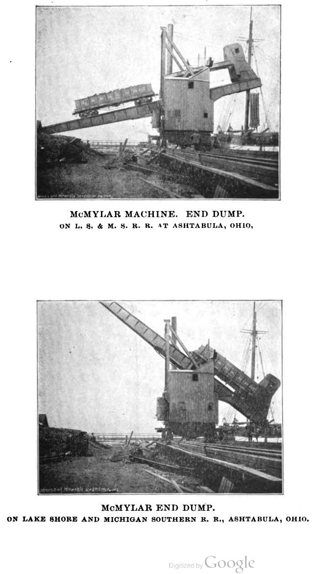
The first unloading machine was installed here in 1895. It was the second End Dump machine built. (The first one was installed by NYC/LSMS in Ashtabula.) The predecessor of the B&O route here was evidently the Pittsburgh and Western Railway because they modified 2000 of their cars so that an end side could be raised as a gate. This machine could unload 15 cars a day with a four man crew. [pp32,38]

Reprints

The need for this B&O bridge is obvious.
Satellite
I was wondering what justified the cost of this bridge.
Satellite

HAER LC-D43-1930 [P&P], cropped
Ohio, Fairport ore docks
ackson, William Henry, 1843-1942, photographer
Detroit Publishing Co., publisher
1892, Commissioned by Pittsburgh & Western Railroad


Dale Pohto posted
Despite the incorrect notation (probably the loading port for this ship), this rare photo (looking NE) is of the U.S. Steel-owned str. Samuel F.B. Morse unloading under the Brown Electric Fast Plants at the U.S. Steel-owned Pennsylvania & Lake Erie ore dock on the east side of the river at Fairport. The homestead of my grandparents (where I spent much of my youth) can be seen to the right of the photo.


Monday, July 6, 2020

Monon, IL: Monon Depot

(Satellite, the curved track goes along the left side of the platform in the photo below)

Dave Arganbright posted
More of the classic 1930's Barriger photos are getting scanned and digitized. Here is a great shot of the Monon depot before it was wiped out in the derailment at speed.

Richard Koenig commented on Dave's post
Really solid work in that collection, and this shot above is no exception! Here's the replacement depot, or yard office perhaps, seen in 2017.
John Jones You can read that story up the road at the museum. Great place to go see a great collection and get a bite to eat. The whistle stop.

Saturday, July 4, 2020

Joliet, IL: Rock Island Commuter Coach Yard

(Satellite, the only thing left is the ramp that went down to the yard. That is now an access road to the bridge.)

Joliet was the terminus for the Rock Island commuter service, so they needed a yard to store the commuter trains overnight. When I commented on the ramp shown in the following photo, I learned that this was the lead to the coach yard. Metra now uses land on the east side of the diamonds for their coach yard. That land used to be part of the Michigan Central railyard.
Halsted Pazdzior posted
Bridge 407 looms in the background as a rail train led by CSX 8842 (SD40-2) heads east.
6/26/20
During the day, the coaches would be parked downtown. They must not have run as many trains back then as they do now because it doesn't look very big.
1939 Aerial Photo from ILHAP at photo resolution
When I studied a satellite image, I noticed that there was a ramp on the south side as well, but nature has "swallowed" it. That ramp descended the other direction down to an industrial lead along the river front.

1939 Aerial Photo from ILHAP
Using street view on Des Plaines Street, one can see that the south ramp is below the mainline and that the north ramp is even further down.
Street View
(Facebooked)


Knox C: Victoria, IL: Little John and Horkstrom/Strom Coal Mine

(Satellite, the mine was on both sides of IL-15 and the tipple was on the west side of the mine.)

Michael Gemstone Willey posted
A couple of photos that were taped `together to create this image. Cleaned it up a bit. Little John Coal mine.
My motivation for these notes is the Little John mine, but I include Horkstrom/Strom because it is geographically so close and because both used the Galesburg & Great Eastern (G&GE). According to the 2005 SPV Map, the G&GE was never bought by another railroad. It was abandoned by the G&GE.

Directory
Directory

Map
In 1940, the Strom mine had been idle for more than a couple of decades, bu the Little John mine had been active for just four years.
1940 Aerial Photo from ILHAP

1944 Galva and Maquon Quadrangles @ 1:62,500
I included some of the land north of the mines in the 1940 aerial and 1944 topo to catch the curve in the G&GE.
Aban RR Map

Michael Gemstone Willey posted

Michael Gemstone Willey posted

Michael Gemstone Willey posted

Michael Gemstone Willey posted
Nick Koba Jr. best job and most important at any coal mine the PUMPER , summer bug bites winter frozen hoses , water never stops summer rains winter drains out of high wall , did that for over 7 years.

Michael Gemstone Willey posted

Michael Gemstone Willey posted

Michael Gemstone Willey posted
Nick Koba Jr. an BE 1150 ?
Michael Davis Yes sir.

Michael Gemstone Willey posted
This looks like a different exposure of the above photo.
Michael Gemstone Willey posted

Michael Gemstone Willey posted

Michael Gemstone Willey posted

Michael Gemstone Willey posted

Michael Gemstone Willey posted

Michael Gemstone Willey posted

Michael Gemstone Willey posted
James Stine Michael Gemstone Willey, is there a date on this photo?
Michael Gemstone Willey It was in a stack of photos which had the date 1953 on the box but I don't know if that corresponds to this image.
James Stine Michael Gemstone Willey , that machine was moved to the Allendale Mine in 1961. 1953 is a good starting point to try and find some information on the boom fall.
Nick Koba Jr. didn't know they had a 950 I new they had a 1050 because I have photos of it when the spoil pushed in and shoved it agaiest the high wall.
James Stine Nick Koba Jr., the 1050 your referring to worked at the Will Scarlet Mine near Stonefort, Illinois.
Nick Koba Jr. thanks James I forgot it was Will Scarlet Mine.

Michael Gemstone Willey posted


Friday, July 3, 2020

Fort Wayne, IN: Traction (Interurban) Terminal

(Satellite, as with so much history in America, it is now a parking lot)

The power plant, storage and repair facilities were further north.

Tommy Lee Fitzwater posted
The Indiana Railroad passenger terminal in Fort Wayne. (Howard Pletcher Collection)
Adrian Strickrott https://youtu.be/JOvF4J6djCs

CassHistory, p31

Dennis DeBruler commented on Tommy's post
On page 21 it states the Traction Terminal was on the corner of Pearl and Harrison.
https://www.casshistory.net/pdf/interurban-allen-co.pdf
The building we see on the right in the photo was on that corner. I think that the tracks were west of that building between Perl and Main and that we are looking North over Main because the smoke stacks that were on the Science Center when it was a power plant are visible in the background.

Tommy Lee Fitzwater posted
1921
Interurban Station
Ft. Wayne, Ind.
 
Tommy Lee Fitzwater posted
Year?
Interurban Station, Harrison St, near Main
Ft. Wayne, Ind
1) no automobiles at all
2) round Bergoff Beer sign
3) 3- or 4-color printing press technology that printed the postcard with a likely-German manufactured printing press that were mostly used in Europe
4) JV209,509 serial number in German handwriting at the postcard manufacturer indicates age and location of postcard printer in Europe
Higher resolution:
Dan'l Miller
 Looks like an early automobile in the center of photo in the higher resolution.
Steve Mensch
, good catch! I hadn’t analyzed the diameter of those wheels & the apparent lack of horse on that one due to facing away. That model of car is the narrowest bound on time: which model looks like that from the rear?And which years was it made?

Keith Petersen posted
FT. WAYNE AND WABASH VALLEY TRACTION COMPANY
This is before my time, but I’d like to see at least one interurban or street car back in service.
[The power plant for this interurban became the I&M Power Plant.]

Mike Snow commented on Keith's post
The history of this car is interesting.. it resided in Mongo Indiana for the approximately 60 years before being taken to IRM for restoration.. I have the history and photos if interested. Fort Wayne & Wabash Valley Traction Co. # 504
Named Talisman
Delivered May 14, 1906
Became the Smith Family Home-Dec 1933
Acquired by IRM-1993
Builder - Cincinnati Car Co.
Cost when new $12,500
They were 7 of these cars built and were as follows:
Ft Wayne & WVTC Co.
#501 Kenilworth
#502 Ivanhoe
#503 Woodstock
#504 Talisman

IUT
#297 Kokomo
#298 Peru

Lima & Toledo Traction CO.
#101 Van Wert

All these cars were delivered between March & July 1906 The railroads were under control of the Schoepf-McGowan investment syndicate at the time of the purchase
of these cars which accounts for essentially the same cars going to 3 different railroads.

Sometime around 1920 the car had it's multiple removed and installed on other cars being constructed being built by the railroad and # 504 was renumbered # 354 after a rebuild.

In the early 30's the car was retired and sit in Fort Wayne IN and that's when this story really starts.

December 1933 Mr & Mrs Charlie Smith pay $150.00 for the car and the moving cost to relocate the car to Mongo Indiana.

Spring 1934 A Carpenter from Hicksville OH boards with the Smith's in return for helping build a kitchen on the east side of the car. The original heater from the interurban was placed in the basement of the Smith home and reconnected to the heater coils in the car. Mrs, Smith states in her diary that she cleaned and varnished the interior of the interurban the same red color that it was.

1940 Mr. & Mrs. Smith buy 80 acres of land and log part of it, The lumber is used to add an addition on the interurban car, A living room, bedroom, and a dining room was added. The interurban was covered with asbestos's shingles like the addition. The house and the interurban were wired with electricity .

1941 The heater pipes were removed and the two bedrooms in the interurban were dry walled.

1979 Body of the car was seen Norman Krentel of the IRM while looking at the old ROW of the St Joe Valley Ry.

1993 IRM Members remove the body for the trip to the IRM in Union Ill,

May 1 1994 Work starts to rebuild # 504 @ IRM

Sept 16, 1995 The car is rolled out of the building by it's own trucks and pulled by it's own coupler for pictures and exterior work.

July 4, 1997 The car is once again on display and the exterior is finish painted and lettered.

Tim Shanahan shared
[Power plant]

Douglas Kyle commented on Tim's share
Greg Runions posted a slightly higher resolution version of this map

Tommy Lee Fitzwater posted
Mar. 18, 1908

I'm going to save this here for now because this is as close as I currently get concerning Indiana interurbans.
Huntington County, Indiana, Time Capsule posted
Map, Winona Interurban Railway Company and Connections: “This is the map portion of a three-part card that provided the Winona's schedule and schedules of connecting lines., according to the online information. Originally, the interburban Winona Railroad was developed to transport the many visitors who attended the Christian Chautauqua in Winona Lake. It expanded to include towns north and south of the Winona Lake area to serve people who lived along the line. (Accessed online: Grace Digital Library. Repository: Archives & Special Collections, Morgan Library, Grace College & Theological Seminary, Winona Lake, Indiana)

One of the advantages of interurbans is that they could use the streetcar system of a town to access the downtown.
Howard Traxmor posted
By the peak of Fort Wayne's ELECTRIC streetcar services in the early 1900's, the Poplar Neighborhood was served on four sides - Fairfield (partial), Taylor, Broadway and Creighton.
The Broadway line was also an interurban connecting with Bluffton, Indiana, and the Taylor line connecting with Lafayette, Indiana. Add to these streetcar and interurban connections, the Wabash Railroad crossed the neighborhood's north side, making the Poplar Neighborhood arguably the number one neighborhood in Fort Wayne history for rail services coverage outside of the downtown business district.  www.3riversweb.org/PoplarNeighbors/Historic
Howard Traxmor shared

Wednesday, July 1, 2020

Detroit, MI: Forest Lawn Junction: CRSA/MC vs. CN/GTW

(MichiganRailroadsSatellite) CRSA/MC is the single-track north/south route and CN/GTW is the double-track diagonal route.

The 2005 SPV Map shows the Forest Lawn Junction in the wrong place because what it labels Belt Line Junction was really this junction.

Charles Geletzke Jr. posted
Working on the Eastward Main Track at the east end of GTW's East yard in Detroit, Michigan on Appril 27, 1984. We see a Conrail yard job crossing the diamond at Forest Lawn tower. The track to my right was the East Lead and at that time still ran all the way to 6 Mile Road. To my left was the Westward main Track and to the left of that you can see where the connection to the Detroit Terminal Railroad was recently removed. We used to have yard jobs that took cars to the DT at Davison Yard until they were acquired by Conrail. Right about where I am sitting we had a set of hand-thrown cross-overs that went all the way across from one side to the other. Beyond the diamond was another set of cross-overs, which were controlled by the operator at Forest Lawn...thus, an eastward train could depart East Yard and not have to slow down or stop to realign the cross-overs! Interestingly, Forest Lawn was NEVER a train order office until late in the summer of 1968! All of the track to the left of the semaphore signal were former New York Central and was actually North Yard. Notice the two dwarf signal on the ground to the right of the East Lead and between the Westward and Eastward GTW Main Tracks. Those were great days! (C. H. Geletzke, Jr. photo)
Mike Burgett: Always wondered what that bracket bridge looked like. [I think he is talking about the signal mast.]
Charles Geletzke Jr. shared
Dennis DeBruler: 42°24'32.1"N 83°02'06.6"W
Charles posted again
We are eastbound on the GTW's Mount Clemens Subdivision on the east side of Detroit, Michigan on April 27, 1984.  We are approaching Forrest lawn tower where the Conrail (former NYC-PC, and Detroit Terminal RR) crossed.  The tracks on the extreme left were also Conrail's former NYC-PC Bay City Branch.  North Yard tower would have been around the curve to the left about 1/2 mile distant. (C. H. Geletzke, Jr. photo)
Eric Kallin: Finally a good photo of the Bracket mast at Forest Lawn with TR-2's.... I've only seen one other one if it. Thanks for posting, Chuck!
Veronica N Matt Bentley: Beltline job. 1st trick job out of North yard.

Peter Dudley commented on his share
Forest Lawn Junction diamonds (Google coordinates 42.408915,-83.035149), and Forest Lawn Tower site.


Peter Dudley commented on his share: "This level crossing is located near the site of Forest Lawn Tower (named after the nearby cemetery). The single-track north / south line there was used by Detroit Terminal Railroad and Michigan Central / NYC Belt Line Extension traffic."

Peter Dudley commented on his share
Now & Then: A small Michigan Central Railroad (M.C.R.R.) roundhouse once stood east of Mt. Elliott Avenue, north of Forest Lawn Tower, in Detroit.
The circular foundation of the roundhouse's back wall is still-extant.
https://www.facebook.com/photo.php?fbid=1665857910339175&set=p.1665857910339175&type=3&theater

Peter Dudley included in his comment on his share
he Belt Line Extension track connects with the original Detroit Belt Line just north of I-94, east of Mt. Elliott Avenue (Google coordinates 42.382845, -83.033207). The Mt. Elliott / Detroit Belt Line grade crossing north of I-94 was removed during GM Cadillac Assembly / Poletown plant construction, but it was re-installed a few years ago.

The Belt Line Extension connects with the Detroit & Bay City Division / North Yard Branch (leading to the Sterling Secondary / Utica Industrial Track) HERE.