Monday, September 6, 2021

Toledo, OH: Swan Creek Tower: NS+Amtrak/NYC/LS&MS vs. Aban/NYC/LS&MS vs. NS/NYC/LS&MS

(Satellite)

Mark Hinsdale posted
"Late, But Moving"
In February, 1977, Amtrak westbound Train #49, the "Lake Shore Limited" has battled heavy Lake Effect snow all the way west from Rochester NY as it rolls through Swan Creek Interlocking, a mile or so west of Toledo's Central Union Station. Running a little over four hours late, the steam visible back in the consist would seem to indicate that at least some portion of the train is still warm on this raw Ohio day. February, 1977 photo by Mark Hinsdale
Mark Hinsdale shared
Dennis DeBruler: I particularly enjoy photos of interlocking towers that catch some of the signaling pipelines.

NYC branched off in three different directions west of this tower.
1952 Toledo Quadrangle @ 1:24,000

Lee Soule posted three photos with the comment: "Swan Creek Tower through the years."
1

2

3

Dennis DeBruler commented on Lee's post
I found it in a 1983 aerial photo, but not in a 1985 aerial.

Mark Hinsdale posted
"Ice Cold Coke"
On a cold and snowy, February day, 44 years ago, a westbound Conrail coke train is crossing over from Number 2 Track to Number 1 Track at Swan Creek Interlocking, in Toledo, Ohio. Swan Creek was the junction of the ex New York Central main line from Toledo to Detroit, with the primary Buffalo to Chicago route. The junction serves successor Norfolk Southern in the same fashion, today. February, 1979 photo by Mark Hinsdale
Craig Harris: I think I was working at Milwaukee Jct in Detroit when they took this tower out of service. I think control went to Stanley tower then.
Mark Hinsdale shared

Michael Shirey posted
B&O 4437 and other C&O units are seen on the Conrail at Swan Creek tower in Toledo, Ohio on November 18, 1981. (Jack G. Tyson photo)
Tim Shanahan shared

Mark Hinsdale posted
Sunday Night @ the Oldies
"Coal For Monroe"
45 years ago, in May, 1979, a trio of Detroit Edison locomotives bring a loaded coal train west on Conrail's Buffalo-Chicago main line through the junction with the Detroit-Toledo line at Swan Creek, on Toledo's near west side.  The interlocking took its name from the creek that passes under the Conrail main line in the immediate vicinity of the tower. Swan Creek controlled the switches and signals associated with the junction, as well as the east entrance to Conrail's Air Line Yard.  Here, the coal train is taking the path north toward Detroit, where it will travel as far as Monroe, Michigan, the location of a large Detroit Edison power generating station, to be unloaded.  These massive trains carried 100-120 tons of coal per car, and typically weighed in excess of 20,000 tons, by far the heaviest trains to run over the route from source mines in PA and WV, to Monroe.  May, 1979 photo by Mark Hinsdale
Mark DuVall: Great photo once again Mark! If he isn't doing over 7 MPH right there, he'll stall climbing up the hill here. Crazy to think that. I, in fact, grabbed a coal train at Vickers and almost stalled coming up this hill. Of course, back before the NS decided to make both mains bi-directional, we had to travel wrong main on a Form D and be prepared to stop at the next signal. To say the least, I think we hit 2 mph at Nebraska, but were able to keep it moving. Fun Times!
Mark Hinsdale: Mark, that's very interesting. I guess I never though much about grades around Toledo, but in doing so, it does stand to reason there would be some kind of a climb out of the Maumee River basin.
Mark Hinsdale shared

Comments on Mark's post

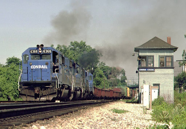
Darren Reynolds posted eight images with the comment: "Conrails (EX- NYC)
"Swan Creek" tower 
Toledo,  Ohio"
Randy Saint shared
Tim Shanahan shared
1

2

3

4

5

6

7

8

Sunday, September 5, 2021

Bound Brook, NJ: NJ Transit Train vs. Flood Gates and Definition of 100-Year Flood

(Satellite)

It appears as though should have put those signals a few feet further west so that the train stops outside of the gates!
Walter Borys posted
Amazing piece of engineering (misengineering?) In Bound Brook, NJ on Sept 2. Remnants of hurricane IDA caused 100 year flooding in this river-bound community. Since 100 yr flooding seems to occur every 20 years, flood gates were built in several low-lying areas, including a rail right of way.
Somehow no one anticipated that there may be trains stuck on the tracks. Neither town nor NJ Transit published any details or comments about this snafu so far...
Kelly Sandford Glover: The folks stranded in those rail cars were some of the last to be rescued, even though first responders knew their predicament. Though afraid and very uncomfortable, it was determined that the commuters were high, dry, and safe.
Walter Borys
[12 hours later]: Finally, 'official' word on what happened, from NJTransit. Around 9:30PM Wednesday, the in-service train got surrounded by surging flood water and debris. it had to stop, and couldn't back up, since it couldn't see the condition of the track behind it. Unfortunately, it stopped in the middle of the flood gate closure area. Local officials decided a little later to close the flood gates, but NJT could not move the train.
James McMillan: The legal definition of "100 year flood" is, in a given year, it has a 1% chance of occurring. Not that, in fact, it's only expected to occur only once in 100 years.
Steve Russo: James McMillan And in that definition, is the actual amount of rainfall and stream flow of so many thousands of cubic feet per second. "100 year flood" is just a term that is used by Meteorologist, climatologists, and Hydrology people, but not really what it sounds like. Just like Astronauts using the term "zero-Gravity", when there is no such thing as Zero gravity". (Along with being a professional in the meteorology field, I am also a professional Astronomer and Space Scientist).
Mark Wallace: James McMillan & Steve Russo: Respectfully disagree. Your definition is used by insurance risk managers and in some legal circles. That is not the USDA or USG definitions hard wired into so many zoning or land-development codes throughout my state (PA) and adjacent states. For the last 45 yrs, I have designed with civil engineers and landscape architects, successful storm-water management systems that held up in Ida's passage on Wednesday based on recorded statistical criteria. Rainfall criteria from a storm is not based on probability but rather is based on actual, comparative, published records sometimes going back 175 to now 200 yrs. These include river heights and amounts of rainfall in 24 hrs down to one (1) hour discharges as maintained by our local Soils Conservation Districts, State Environmental Depts, Highway dept., USG and others. What is happening due to climate changes; the 10 yr and 25 yrs storms are now occurring every 1 or 2 yrs! I've seen two 50 yr storms in 1972 & 2011. The Ida remnants rainfall amounts were impressive and in fact exceeded the 7.8 inch amount in 24 hrs, putting it squarely in the 100 yr territory for my community. Based on climate changes I would never, since hearing the "probability definition," ever gamble using those odds.


So why didn't they send a supervisor out to the back of the train and allow the engineer to use his cell phone to call him to get eyes at the back of the train? Sometimes managers need to use some common sense rather than just quote the rule book.

I had trouble finding the satellite image because I was looking for tracks going across a river. Then I realized that Middle Brook became a river during the flash flood. 

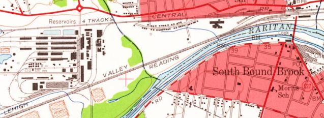
This route was used by Lehigh Valley and Reading Railroads. It is evidently now owned by NJ Transit.
1955 Bound Brook Quadrangle @ 1:24,000

Street View


Saturday, September 4, 2021

Newnan, GA: NS/CofG vs. CSX/A&WP and A&WP Coaling Tower

Crossing: (Satellite)
A&WP Coaling Tower: (Satellite)
Joint Depot Foundation: (Satellite)
A&WP Freight House: (Satellite)

CofG = Central of Georgia 
A&WP = Atlanta & West Point

Chris Ness posted
Newnan coaling tower
Coaling tower over the Atlanta and West Point just south of the intersection with the Central of Georgia at Newnan, Georgia. The combined station was located in the NW corner of the junction. This view is looking north.
11/07


Street View
Dennis DeBruler commented on Chris' post
I noticed on a satellite image that you could still see some walls of the depot's sidewalks. And this street view shows that grass can grow out of the depot's sidewalks/platforms but not out of the slab for the depot itself. And of course the tower is in the background.
NS now has the C of G, and CSX has the A&WP.

Dennis DeBruler commented on Chris' post
I was surprised to see this building labeled as an historic depot.
33°22'28.1"N 84°47'48.2"W
I'm willing to believe it is an historic railroad building, but I believe it was the A&WP's freight house.
Chris Ness: You are correct.

Dennis DeBruler commented on Chris' post
This topo map shows that there used to be a siding along the freight dock that still stands north of the freight house.
1965 Newnan South Quadrangle @ 1:24,000
Chris Ness: And where are those people who got all critical for me calling a coaling tower a tipple? I rest my case.
Dennis DeBruler: Chris Ness I'm in the school of thought that "tipple" is the structure in coal mines that cleans and loads coal for shipment. So I think the cartographer made a mistake.

Chris Ness commented on the topo comment
That water tank is not on A&WP property. That is this 100 year old tank fabricators and foundry.

Chris Ness posted
Newnan's coaling tower.
Atlanta & West Point (CSX) being crossed by the Central of Georgia Rail Road. (NS) Looking South-west towards West Point.
Newnan, GA 11/07
Jim Preece: There are two of these in the Newnan area. The second tower is just off highway 16 in Raymond, GA.
Keith Moody: Jim Preece C of G one.

Trainbook posted
At the Crossroads
Coaling tower where two sets of tracks come together in Newnan, GA., Coweta County.
Photo and words by Leo Hohmann.
Here it is on Flickr:

Friday, September 3, 2021

Walbridge, OH: CSX/C&O/Hocking Valley Walbridge Railyard and Junction (WR) Twoer: Pennsy vs. TT vs. HV

Railyard: (Satellite)
Tower: (Satellite, based on the aerial photo below.)


Barry Sell posted
Toledo Photographic Service
This black and white photograph shows an aerial view of the Chesapeake and Ohio Railroad.
No other description is provided from the Repository, Toledo Lucas County Public Library Ottawa Yard?
Christine-John Yontz: This is Wallbridge yard. At the bottom left of the photo is the PRR line from Tiffin coming in and in the background you can see the cars at the Toledo and Ohio Central's yard (Stanley Yd, not sure if was called that back then). The coaling tower is where the modern day car shop is (still in use?) and if you look and Google maps you can still see some of the track from the roundhouse south of the car shop. Again, most of the tracks in this photo are gone in Wallbridge yard.
Matthew S. Smith: Was there always a hump? It almost looks as if there is no hump yet.
Jim Sank: Matthew S. Smith hump is out of view to the left

1935 Walbridge Quadrangle @ 1:24,000

2 of 14 photos Craig Hensley Photography posted with the comment:
CSX P001-06 - October 2022
The CSX Office Car Special (OCS) made another trip up through Michigan today. There's been a ton of speculation about why the business train has been up to Michigan 3 times in the last year or so. To be honest, I have no idea why, but it does make for a fun and interesting chase, especially with some fall color is beginning to pop. I made a little adventure out of it by catching up with the train down in CSX's yard in Walbridge, just south of Toledo. I ended up chasing them back up to Plymouth, although I did skip the Detroit leg of the trip. More details in each picture!
J.B. Rail Photog shared
a

b
 
Howie Castellucio commented on Ken Kieley Jr.'s post
"WR" Walbridge tower.

Darren Reynolds posted eight photos with the comment:
PRR. ( C&O.. TTRR..)
Walbridge tower "WR"
Toledo,OH.
Darren Reynold posted seven photos, which I did not repeat.
1

2

3

4

James Anders commented on the fourth photo

5

6
[The comments explain that the two white radiators cool the air that operates the signals and turnouts to remove any water in the system.]

7

8
All images from North American interlocking website

Zachary C. Gi9llihan commented on Darren's post
I need to paint it that US&S olive green but here’s the machine partially restored.

May 1, 1963 @ 24,000; AR1VARA00010033

Thursday, September 2, 2021

Ware, IL: Wooden Grain Elevator

(Satellite)

The railroad is now UP+BNSF. It was SIMS+SSW. SIMS was St. Louis, Iron Mountain & Southern, which became MoPac. SSW was St. Louis Southwestern Railway (Cotton Belt), which was a subsidiary of SP.

Street View

John Krattinger posted
Ware, Illinois.

Street View


Chicago, IL Depot: Rock Island Depot at the Pennsy Panhandle in Beverly Hills

(Satellite)

This station was at the crossing of the Rock Island's branch line with the Pennsy's Panhandle. The station where the Rock's mainline crossed the Panhandle was in Washington Heights.

Andy Zukowski posted
The Rock Island Railroad Depot at Beverly Hills Station, Chicago, Illinois. 1917   Photo by C.R. Childs
In 1917, the Rock Island Railroad served the Beverly Hills area of Chicago, Illinois. The Rock Island had built a branch line, known as the Beverly Branch, to serve the communities in the area. The original line dated back to 1869.
Peter Jirousek: Yes just past the PRR Panhandle line. And within view of B&O’s line to Chicago’s Grand Central Station. Imagine the Capital Limited drifting by…

Marty Bernard posted
3. CRIP 400 Crossing PRR at 91st St., Chicago, IL in December 1964. A Rick Burn photo.
One of the Rock's only two Fairbanks Morse H15-44. Built in Dec.1948 and both were repowered with EMD engines.
Jeff Lewis: There don't appear to be northbound platforms at that time.
Stuart B. Slaymaker: Most of the Subn Line stations only had a platform on the west side, in front of the station. 95th Street was an exception. The platforms on the east sides, have been since the RTA/Metra takover in the late 1970s.

Marty Bernard shared
Marty Bernard shared

It appears the dormer in the north roof has been removed.
Street View


Wednesday, September 1, 2021

Sauget, IL: GM&O/Alton Tolson Yard, 1923-1976 240mw Cahokia Power Plant and Marine Terminal

Power Plant: (Satellite and Satellite, the coal handling facility has been repurposed as a barge-to-land facility)
Railyard: (Satellite and Satellite, once again, the brownland of a rail yard is now used by cleanup companies)

Mason Reed posted
The Gulf Coast Rebel on a turntable at Tolson yard.
Randall James: ALCO DL-105, really rare, only two 105's were ever built #'s 270 & 271 , #272 was the only true ALCO DL-109 the GM&O owned, was built in 1940 for the Gulf Coast Rebel St Louis to Mobile AL 1940-1958
Randall James shared

Russ Hawkins posted
That is a power plant right across the river, right at — 2 mile south of the arch in ST. LOUIS, MISSOURI.
 It is still there, it had 24 boilers, that provided steam to a common steam header, - - > > that went to 6 turbine generators.
 All of those boilers and turbine generators made - on a good day - 240 Megawatts.
The picture was taken in 1953.
Tim Stehle: Multiple boilers feeding a common "low pressure" header in early days was fairly common. Esp as boiler tube metallurgy was still developing, so loss of a boiler wasn't a huge hit on capacity, as Boilers were often "under rated".
If 24 truly were common headered to 6 units, turbines and FW were clearly simple cycle. Of course, dedicated FW heating to improve efficiency in a 24 -to-6 arrangement would be complicated - extraction stage steam quality from many identical units at different loads would not provide a stable FW inlet temperatures for distant boilers.
All of that said, one header could have been used but normally segregated between groups of four boilers to feed two units, and the ties lines opened only when "emergent".
Plus process improvements in later years could be hidden behind the brick. If not for plant like this, "Chinese Laundries" might still be using scrub boards and clothes lines 🙂
All in all, a nice post and source of wonder on how we got to today from the initial plant facilities such as this.

John P. Kohlberg posted two photos with the comment: "ICG(GM&O(M&O)) Tolson Yard - East St. Louis, Ill., circa 1982, Long Photography Kodachrome.  Cahokia Power Plant looming in the foreground."
Darion Fox: Do you have anymore of that yard? [Responses with images below.]
John P. Kohlberg shared
1

2

John commented on Darion's comment

John commented on Darion's comment

Dennis DeBruler commented on Darion's comment
I included the Alton & Southern because it reminded me that the Tolson Yard was originally just M&O. The GM&O merger of 1947 has yet to be reflected on the map.
1949 Cahokia Quadrangle @ 1:24,000

Arturo Juarez posted
Cahokia Power Plant
Sauget, Illinois
Brett Wanamaker shared
 
William A. Shaffer posted
Smokestacks by the River. (9.29.17). 
E. St. Louis, IL
(Photo by William A. Shaffer)
 
Dennis DeBruler commented on William's post
They were being removed in Jun 2023, https://maps.app.goo.gl/wSqqYboZUxmSsA3z9. And they were gone by Dec 2024.

It look like they did not make much progress for a year and then they made a lot of progress during the second half of 2024.
stlouispatina, Jul 3, 2024

stltoday, 1947, Post-Dispatch file photo
[In the center is the MacArthur Bridge.]

A photo showing lighter smoke coming out of the stacks.

Joel Flickr, 2009, License: Creative Commons Attribution-Share-Alike (CC BY-SA)

Cahokia Power Plant

This monolithic coal powerplant was completed in 1939 and deactivated in the 1970's. Since this is such an imposing landmark, I'm sure some awesome photographs have been taken of this structure, this is not one of them. Lol.


This was taken from the Missouri side of the Mississippi River looking across into Illinois. Apparently the property is still being used by a river transportation company. I'd love to take a look inside.


I've seen the same text on multiple web sites. I believe this is the source of the description.
BuiltStLouis [This page has several more photos]
The power plant circa 1954. Scan from "St. Louis Views", Will Shelly, publisher.
"The Union Electric-operated plant first came online in 1923; it was built in stages and completed in 1939. Designed to burn Illinois coal, it was the largest power plant in the Mississippi Valley when it opened. Its boilers consumed a ton of coal every 30 seconds, and over 600 million gallons of water a day. Underwater cables fed the electricity produced to the thriving city across the river. The plant later converted to oil burning.
"By 1976 the plant had been replaced by newer facilities and was decommissioned. Union Electric sold off the property in 1979. Extensive asbestos insulation used in its construction remained a problem for at least a decade, acerbated by careless salvage work.
"The site today is home to Cahokia Marine Services, a multi-modal transportation business run by SLAY Industries; it functions as a bulk commodity transfer site, loading river barges. The site offers a large volume of indoor storage, presumably referring to the power plant building."

I was not able to find the rated megawatt capacity of  this plant. I did find some details about its coal consumption.
Constructed in stages between 1923 and 1926, Cahokia was the largest electrical power plant in the Midwest upon its completion and was the first designed to burn low-grade Illinois coal in pulverized form....The Cahokia Power Plant was equipped with fourteen boilers and consumed coal at the rate of one ton every 30 seconds. This represented seventy-six carloads of coal every day and 1,250,000 tons of coal per year. After arriving at the plant in train cars, the coal was dumped, run through a drier, and then crushed into a fine, pulverized powder that was blown into the boilers (East St. Louis Daily Journal 30 November 1924, sec. 4, p. 1, col. 5; 11 May 1930 p.10D, col. 8; Federal Writers’ Project 1983:492). Much of the coal consumed at the power plant came from a company-owned strip mine located outside of Freeburg in St. Clair County (Department of Mines and Minerals 1929:166, 170).6 [IllinoisArchaeology]

JakubStepanovic, this is one of many photos of the St. Louis area. Near the end are industrial ruin photos.

I don't see petcoke in this list, so I guess the black piles in the satellite image are coal instead of petcoke.
Cahokia Marine Service:
-84-acre intermodal river terminal in Sauget, Illinois
-Bulk liquid and dry products transferred in and out
-Barge, rail & truck enabled
-Products include coal, copper, steel cement & iron
-32,000 feet of railroad track with 6 locomotives
-Served by BNSF, CSX, Gateway Western/KCS & UP railroads
-5 million gallons liquid storage
-Drum and distribute chlorobenzene products
This photo confirms what I saw in a 3D Satellite image, they unload barges as well as load them. They also handle tanker barges. I'm presume that these silos handle cement. The powerplant building is now used as a warehouse. The coal goes to trucks, not rail.
Cahokia Marine Terminal, Mar 2021