Monday, June 3, 2024

St. Thomas, ND: Four Wooden Grain Elevators

From North to South:

The two northern elevators:
Street View, Oct 2012

Middle:
Street View, Oct 2012

Southern:
Street View, Oct 2012

All four looking north:
Street View, Oct 2012

Jerry Krug posted three photos with the comment: "St. Thomas, N.D.  Was once served by the Great Northern Railway.   Photos taken May 26, 2024.  With Patti Orzel."
1

2

3

Meyersdale, PA: B&O Coaling Tower Demolition

(Satellite?)

Some of the comments remember it being torn down in the 1950s. And the oldest aerial photo that I could find was 1960, so I was unable to find its exact location.

Martin Staub posted three photos with the comment: "The demise of the coaling station between Meyersdale and Garrett."
Mike Klink shared
1

2

3

1944 Meyersdale Quad @ 62,500

New Brighton, PA: 1927 Diamond Milling Co., an Upgraded Wood Feed Mill

(Satellite)

This is obviously a feed mill in addition to a urban lawn and garden shop. Note the feed truck on the right side of the photo.
Street View, Jun 2023

While looking for street views of a Pennsy railroad bridgePennsy railroad bridge, I spotted a red checkerboard on a building. So I found the above better street view of that building.
Street View, Jun 2023

DiamondMilling

Their "Large Animal" webpage:
DiamondMilling_large

Sunday, June 2, 2024

Clarion, IA: Lost/C&NW/CGW Roundhouse

(Satellite)

Richard Fiedler posted

The oldest topo available is 1978, and, as expected, the roundhouse has been removed.
1978 Clarion Quad @ 24,000

The roundhouse was south of where the CGW crossed the Rock Island and west of 5th Ave.
Oct 18, 1950 @ 70,000; ARA000700403982

The grain elevator along the former-CGW route does not have rail service.
Satellite

The grain elevator along the former Rock Island is a lot bigger.
Satellite

And it looks like it has rail service. But the hoppers have 2 bays instead of 3. Grain and potash use 3-bay hopper cars. 2-bay hopper cars are for something heavy like sand. Also, there is no fall protector. So I assume that something is being transloaded for an industry.
Street View, Jun 2021

According to the 2004 SPV Map and a USGS map, UP now owns the CGW routes west and northeast of town and the Rock Island route east of town. The CGW route to the east and the RI route to the west are abandoned. I was checking current ownership because I assumed, since there was rail service in this town, that the routes were now owned by a shortline. Is UP willing to behave like a shortline on its branch lines and provide some local service?

Trent Briggs posted
Clarion, Iowa
Monte Olsen: About what year does anyone think?
Trent Briggs: Monte Olsen 1910 ish


Malta, IL: C&NW Depot and 1920,2017 Grain Elevator

Depot: (Satellite)
Old Elevator: (Satellite)
New Elevator: (Satellite)

Larry Foht posted
Chicago North Western Railroad Depot 
Malta Illinois 
Larry Foht collection :
Dennis DeBruler: This photo is another reminder that C&NW did left-handed running. The train is westbound. There is a house track on the other side of the depot.

1937 De Kalb Quad @ 62,500

1939 Aerial Photo from ILHAP

I've never seen such a small soybean processing plant.
Satellite

They use some old wooden boxcars for storage.
Hans Goeckner, Feb 2017

Satellite
They quote prices for hard red winter wheat and oats as well as for corn and soybeans.

safe_image for Old Time Elevator: New Life Under New Ownership

GrainJournal, Photo by Bruce Selyem
"Northern Illinois Soybean Processing operates this 1921 concrete grain elevator in Malta, IL."
When built, the capacity was 30,000 bushels.


Saturday, June 1, 2024

Mackinaw, IL: Illinois Terminal Mackinaw Junction and Depot

Junction: (Satellite)
Depot: (Satellite)

Andy Zukowski posted
Illinois Terminal Railroad at Mackinaw Jct. Near Mackinaw, Illinois. 1915
Richard Fiedler shared

Larry Candilas commented on Andy's post
A few years later

Even though it looks like the junction building could accommodate passengers, this location is far from downtown. So I looked on the aerial photo for a depot that is closer to town. Not only did it have a depot just east of Main Street, but it is also extant!
Street View, Jul 2023
Dennis DeBruler: The depot still stands just east of Main Street, https://maps.app.goo.gl/SXQzgKrLRR92WzMX7. The agent's bay window confirms that the tracks passed the depot on the north side.

Noah Haggerty posted two photos with the comment: "The former Illinois Terminal interurban station at Mackinaw, IL circa 1975, closed in 1953 with the tracks ripped out and with a new owner, the Illinois Power Company in the building. It still survives as a tea room today. John & Roger Kujawa Photo, Thomas Dyrek Collection."
Connor Bounds: Sure is odd looking.
Tyson Park: Connor Bounds The porthole type openings were for wires as it had a dual function as a substation.
Richard Fiedler shared
1

2

Note the "white dot" in the left fork of the wye on the west side of town.
1939 Aerial Photo from ILHAP

Note the black rectangle in the west fork of the wye. The IT paralleled the Big Four on the east side of town and the Pennsylvania on the west side of town. And it had a route that went south on the west side of town.
1932 Mackinaw Quad @ 62,500

Ross Brocksmith posted two images with the comment: 
Mackinaw Jct
5-15-38
—-
The vertical fixtures on the bright side of the building…electrical gear of some sort for this electrified rail system?
- - - - - - - - - - - - - - - - - - - - - - -- - - - - - - - - -
Image Source/Credit: 
Ernest Grassel Collection
Only seen in-person in the Local History Collection
Downtown Branch of Peoria Public Library
#peoriapubliclibrary  #peorialocalhistory  #ernestgrasselcollection
From Grassel’s volumes titled TRANSPORTATION
Richard Fiedler shared
Richard Fiedler shared
1

2


Missoula, MT: Natural History Museum/Milwaukee Depot and NP roundhouse

Milwaukee Depot: (Satellite)
NP Roundhouse: (Satellite)

The Milwaukee Road built some rather impressive depots.

Street View, Aug 2019

Jim Arvites posted
View of the eastbound Milwaukee Road passenger train "Olympian Hiawatha" making a station stop Missoula, Montana circa 1950.
(Al Chione Collection)

John Harker posted
Here is a very recognizable location with a Milw west bound freight approaching the Missoula, Montana station in August 1968.  The south Higgins Avenue bridge offered a good vantage point for this scene.  Would this be train 261C, Chicago to Tacoma?  Joe E76 was leading newer main line power GP40s.  Note the snow shield over the air intake on 2051.  The GP40 order for 2047 thru 2056 were built with snow shields.  I scanned and edited this image from a 127 format Kodak processed Kodachrome duplicate slide.  John Harker collection
John Harker also posted
Craig Lacey: E75 still has its B-end cab in place.

I noticed in the street view at the top of these notes that they preserved a signal.
Street View, Aug 2019

Street View, Aug 2019

This topo map made it easy to know where to look on the satellite map.
1964 (Northwest, Southwest, Northeast and Southeast) Missoula Quads @ 24,000

Unlike most towns that have a museum in their depot, this museum is not a railroad museum.
Mark Jones, Sep 2021
.

Northern Pacific Roundhouse


Greg Harper posted
Northern Pacific Railway’s Missoula, MT roundhouse.
April 29, 1947
Photographer: McKay, R. H. (Rollin H.).
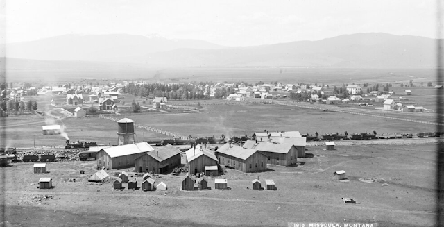
Dave Hahn: here it is again in 1884 Haynes, F. Jay (Frank Jay), 1853-1921 https://www.mtmemory.org/nodes/view/105664...

Terry B. Carlson commented on Greg's post
As you can see in this 2023 Google Earth Image, the TT is still there, but that's about all.

Dave's link
"View of Missoula, Montana Territory, with the Northern Pacific Railroad repair shops (roundhouse), water tower, and tracks with multiple steam engines parked on them in the foreground. Many residential buildings of town are visible. Lolo Peak and the Bitterroot Mountains in the distance. Seven engines visible on railroad tracks. Vintage negative number: 1816."