Wednesday, February 24, 2016

Toledo, Area, OH: Stanley (SA) Tower: CSX/TT vs. CSX/Big4/TOC

Satellite
I labeled the "town" Toledo Area because this area is still rural. Most of the development in the Toledo area is north of the Maumee River.

TT was Toledo Terminal and ran east/west through this junction. TOC was Toledo & Ohio Central. It became part of the Big Four and thus became part of the NYC. In addition to the north/south route that went south to Stanley Yard and then Fostoria, OH, TOC also had a route leaving this junction towards Findlay, OH. Since the TOC route to Fostoria paralleled the Hocking Value route to Fostoria, Penn Central abandoned it south of Stony Ridge.

Howie Castellucio posted
Howie's comment:
SA tower, Stanley tower just north of Stanley yard in Toledo.
Would visit old Bob Sapp. An original NYC operator!!!
I was there on one of his last days. Before he retired. He usually was a vocal character during work. That day......I think ol Bob just may have shed a tear somewhere during that last shift I visited him . On that warm Sunday morning in 1994. 
Pictures of the tower were taken that day. Old Bob wouldn't let me take a photo of him.
He always had a pot of hot coffee though. The spoon would almost stand up in it!
Howie Castellucio posted

Howie Castellucio posted
Skip Cubbedge posted "Inside Stanley Tower (And More!)" video. It is trains rolling by until 5:38, 7:28, 8:46 (but just talking and thinking), 11:48 (some coffee drinking). I had trouble hearing the conversations. But you can easily hear the "pounding of the diamonds."

Darren Reynolds posted six photos with the comment: "Conrails (EX-NYC)
"Stanley" tower 
Toledo,  Ohio"
Tim hanahan shared
Christopher Allen Howe: Model board is on display at Marion Union Station in Marion, Ohio
1
"Stanley" tower was at the crossing of the NYC And the
TTRR..
Photo by: Dan Maners May 2001

2
The model board at "Stanley" tower May 2001
Photo by: Dan Maners

3
The interlocking machine at "Stanley" tower
Photo by: Trey Kunz May 2001

4
"Stanley" tower on January 11, 1982... I wonder what this looks like today?
Photo by: C.H.Geletzke Jr.

5
A TTRR caboose passes "Stanley tower 1989..
Photo by: Charlie Whipp

6
A Conrail track and interlocking diagram for "Stanley"
Interlocking (tower)
James K. Meeker Sr: And the road to the tower next to yard E was called Sapp Avenue after a tower operator I worked with.

B Tupper Upham commented on Tim's share
Model board being lovingly restored by Pete White


Tuesday, February 23, 2016

Detroit, ME: Feed Commodities Grain Elevator is Served by CSX/PanAm/Maine Central

If you are here because of "Milwaukee's Galewood Yard, Freight House and Roundhouse," then you should go there.

Feed Mill: (Satellite)
Fertilizer Sales (I think): (Satellite)

Street View, May 2023

I noted this elevator because it is another example of a feed mill having many small bins.
Dan Markey posted
Feed Commodities Elevator, Detroit Maine, 1/24/2025 served by CSX rail (behind buildings

I was surprised that I saw just one feed truck in the above street view, but then I realized that during the day most of their trucks should be out on the road making deliveries. I did find another truck a little further east. In fact, it looks like a 22-wheeler.
Street View, May 2023

When I looked at a satellite image, I noticed that this mill is rail served. (I read Dan's Facebook comment after I had done the following research to determine the mill was served by CSX. I'm including the research anyhow because it does have some additional information.) Having rail service would explain why the "small bins" of this feed mill are rather large. They need to be able to store carload shipments of feed supplements.
Satellite

The railroad was the Maine Central
1955/57 Pittsfield Quad @ 62,500

The same siding serves an agricultural supply facility.
Satellite

This view of the feed mill and its rail service is from the top of the leg in the ag supply facility.
Brann Mike, Jun 2018

MDOT, p11

MDOT, p10

I had assumed it was one of the shortlines because I know of grain elevators in the Midwest that CSX refused to serve because they could handle only "short" unit trains. So, I got a lower-resolution topo map to interpret the MDOT map. Imagine my surprise when I learned that the mill is on the CSX mainline between Lewiston and Bangor.
1961/61 Bangor Quad @ 250,000


Sunday, February 21, 2016

Chicago, IL: Merchandise Mart

MWRD shared, 1949
Most people know the Merchandise Mart as the worlds largest building when it was opened on May 5, 1930 (mmart). But it must have opened before it was completed because Marchitecture states "At the time of completion in 1931, the Mart was the largest building in the world at four million square feet." It remained the largest building until 1941 when the Pentagon dethroned it. (ViewOnCities)

Facebook
Resolution
Note that you can see the Kinzie Street RR bridge in the down position in the center of the photo just to the right of the cold storage building.

I know of it as the building that displaced the C&NW Wells Street passenger station. To get the two blocks it needed in a downtown location, it was erected on the air-rights of the C&NW railroad yards. As a side effect, it help beautify the river front by hiding the rail yards. (mmart) The bridge to this station was a bottleneck, so C&NW wanted to build a new station west of the river anyhow. So leasing the air-rights was a win-win.

Monique Kielar Lyle posted, 1928
My motivation for writing this posting now is that I came across some construction photos
Posted by Bill Weiss and Uraiwan Dutkiewicz, 1929
Jeff Nichols posted, August 1930
Aerial photo of the Merch Mart, August 1930.
Source: Detroit News Photo Collection,
Wayne State University.
The 1931 date for completion must be wrong, because it looks done in this August, 1930 photo. But the thing that caught my eye is that you can see how the land is still industrial west of the building and how the tracks go under the road and building. The Kinzie Street RR bridge is on the left by the cold storage building.


Evidently each Christmas Season they used to light it up with additional lights because I came across these photos for 1953 (note the tree in the middle), 1954 (note the Lindbergh light on the old Palmolive building), and 1967 (note the religion neutral "PEACE ON EARTH").

Update:
Eric Dudi Huebner posted
Merchandise Mart Roof
Flying Carpet promotion for floor covering show.
1957

Mike Tuggle posted
Wolf Point and Merchandise Mart in 1954.
[Note the coating of black from coal soot. It was still white in the above 1930 photo. In the 1949 photo at the top, you can also see the lower stories are darker than the upper stories.]

MWRD posted from:
Linda Connelly posted
1928. "Site of the Merchandise Mart"

Cindy Anthony Drabing shared, 1929
Raymond Kunst posted from an album
Sharon Avendano shared a David M Laz post
Merchandise Mart under construction as of December 30, 1929. The exterior did not stay clean for long!
Eileen Priest Worked there in the 1990's and had assigned parking in the 2nd lower level of the underground parking area. Massive support columns were evenly spaced throughout the entire "floor". There'd be a column, then 2 parking spaces, another column and another 2 parking spaces, and so on. The columns ate into the striped space set apart for the car so parking could be tricky if the person in the space next to you parked weird.
Leonard Lelko Largest building in the world at one time . Pertaining to floor space .

Pierre Hamon shared
Linda Connelly posted
The Merchandise Mart under construction, seen from the Lake Street Bridge in 1929. Chicago Tribune Archives.
Garry Buzard Wasn't the Merch Mart the largest office building in the USA until the Pentagon was built?
Michael Durkin The Merchandise Mart has 4 million square feet of floor space while the Pentagon has 6.5 million square feet.
Ana Guera Built in 1930 by Graham, Anderson, Probst, and White. For Marshall Field. It was supposed to be a wearhouse for his department stores, but it was built around the great depression. Sold it in 1945 to Joseph Kennedy for 17 million, 13 million than the original cost. In 1998 the Kennedy's sold it for over 450 million. 2nd largest building in America in floor space. For many years carried its own zip code. (60654)
Ronald Wiggin When I worked there in 1969, I found out that all the radio studios had been torn out replaced by giant color TV studios. Sorry I missed the radio period. I heard that Amos and Andy came out of Chicago. Also due to Chicago being about the center of the country and the broadcasts being on copper cables wrapped to about 8 inches round before the insulation casing, those cables spread out from that point to all over the country like a spider web broadcasting from Chicago. Lots of radio personalities lived in Chicago. Not to mention that due to radio being so big in Chicago, the advertising agencies were major there, more than NYC, and is still there.

This uncropped version shows some of the commerce on the river.
Illinois Memories posted
The Merchandise Mart under construction, 1929.
Photo courtesy of the Chicago Tribune-historical photo

Raymond Kunst posted from an album
FP Martinez posted
[Years of coal soot.]
US City Views posted
Chicago - Merchandise Mart (1951)
By 1951, the Merchandise Mart in Chicago had firmly established itself as the world’s largest commercial building and a central hub for wholesale goods. This massive Art Deco structure, opened in 1930, spanned two city blocks and contained over four million square feet of floor space. It housed showrooms for manufacturers and wholesalers of a wide range of products, from furniture and home furnishings to apparel and accessories. The Mart's strategic location along the Chicago River facilitated easy transportation of goods, solidifying its role in the city's commercial landscape. The Merchandise Mart was not only an architectural landmark but also a bustling center of trade and commerce, reflecting Chicago's economic vitality.
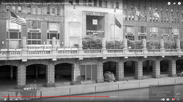
[And the C&NW had tracks underneath it to serve its loading docks.]

This video has a lot of information about the Mart. I highlight the part about the C&NW freight yard that was under the building.
30:31 video @ 18:22 (source)

A 1930 view of the river side. What amazes me is how low the buildings were so that you could get a clear shot of the river side from so far away.

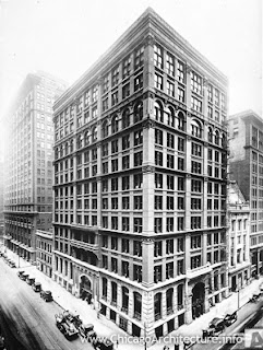
Chicago, IL: 12-Story Home Insurance Building -- The First Skyscraper

Hillary Marzec posted; ChiArchInf
Hillary's comments:
We had the world's very first skyscraper! The Home Insurance Building, built mid-1880s, first building to support its weight entirely with metal skeleton frame construction. Torn down in 1931. Everyone knows Frank Lloyd Wright, but like I explain on my tours, you've got to see the "family tree" that leads to him: this guy -- William LeBaron Jenney -- was like the grandfather/patriarch of them all.
Place-wise, you're looking at the NE corner of LaSalle and Adams. This one was torn down to make room for a beautiful Art Deco building (the FIeld Building). So, sort of a win-win. 
Follow the "posted" link for comments about how Jenny fit into the "family tree" and the importance of Otis inventing the safety brake for elevators. Follow the Chicago Architecture Info link for more information on the building's design. Specifically, it used an iron/steel frame rather than stone walls. Before this building, 5 stories was the practical limit for a tall building.

smile emoticon

Schneider, IL: Junction Tower: NS/NYC vs NS/NYC

(Satellite)
Brian Knight posted
West side of Schneider tower in 1979


Dale Burkhalter posted
Schneider Tower. Where the Kankakee Line crossed the Danville Line.
Tom Windt shared a Flickr photo of a Milwaukee crew change.
Tom Wendthttp://sooline.railfan.net/photos/santucci/latta2.html Some history behind why the Milwaukee Road was in Schneider IN.
This junction is part of the Kankakee Belt Route. The junction is intact because of an industry on the south side of town. But the track is not used south of town.

Update: Flickr with a westbound Conrail train.


Saturday, February 20, 2016

Bureau Junction, IL: Rock Island's Coaling Tower

Roger Kujawa posted


The coaling tower served not only the mainline to the west, but the small engine service facility in the wye between the mainline and the Peoria branch.

In the aerial photo, the coaling tower is near the left along the top. Note the small roundhouse.

Also note a Hennepin Canal Lock in the lower-right corner of the aerial photo.
1941 Aerial Photo from ILHAP

Barriger

Barriger
[Bob Lipka: Water tank and roundhouse on the right.]

Michael Jorgensen posted
CRI&P under the coal tipple.
Harold J. Krewer Yes, appears to be Bureau, looking west. Depot is behind photographer.
Paul Jevert shared
Rock Island Coaling at Bureau, Ill.

Andy Zukowski posted
Rock Island Train Coal Chutes, Bureau Illinois. C1910

Trent Briggs posted two photos with the comment: "Bureau, Illinois
 1910"
1

2

I thought this was a duplicate, then I noticed the steam image in this photo.
Trent Briggs posted
Bureau, Illinois

Friday, February 19, 2016

Philadelphia, PA: Amtrak/Pennsy Overbrook Tower

If you are here because of "Nova: Junction Tower VN: CSX/B&O vs Aban/LAS," then you need to go there.

(Satellite)

Street View, Aug 2024

Street View, Aug 2024

Peter James Paras posted ten images with the comment: "Amtrak's Overbrook Tower. Location: Philadelphia, Pennsylvania.  Built by the Pennsylvania RR.  Overbrook is on Amtrak's Philadelphia - Harrisburg Route Main Line and is still in service today.  It controls Overbrook, and Valley as far as I know.  Not my photos."
1

2

3

4
Old interlocking machine

5
Old interlocking machine

6
Back side of old interlocking machine

7
Newer interlocking machine

8
Newer interlocking machine

9
Track, switch and signal diagram

10
Track, switch and signal diagram


This photo has been moved to "Nova, OH: VN Tower."

This photo has been moved to "Nova, OH: VN Tower."

This photo has been moved to "Nova, OH: VN Tower."