Saturday, December 5, 2020

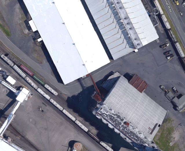
Chester, MT: EGT Grain Elevator and Old Grain Elevators

Old1: (Satellite)
Old2: (Satellite)
Oldish: (Satellite)
EGT: (Satellite)

Street View, Sep 2022

"Oldish" in the foreground and "Old1" in the background. 
Jan Normandale posted
Chester MT: 2013 08
Pentax 67, 55mm, 120 Fuji Acros, ISO 100
tripod + cable release

Old2:
Street View, Sep 2022

The above street view is very incompatible with the Google Maps image.
Satellite

So I fired up Google Earth to check it out. The above image is dated Apr 2016. By May 2021, they had rebuilt all of their bins and greatly expanded their "long building."
Google Earth, May 2021

The elevator has many small bins because Stricks Ag handles specialized crops such as peas and lentils. That explains why there are just seven hoppers at the elevator in the above image. The other recent images shows that the elevator does have a lot of carload rail traffic.
Google Earth, Aug 2023

I wonder if it is also still a feed mill.
Street View, Jun 2009


Andrew Tuttle posted
Chester, Mt
Keith Higgins: EGT loves ground piles.

Dennis DeBruler commented on Andrew's post
Obviously they can ship by rail because they have the loop track for unit trains and a rather long fall protector.
This is the former Great Northern route.

The elevator is capable of loading a 110-car unit train in under ten hours. Since Longview, which has a unloading capacity of 120,000 bu/hr can unload a 110-car unit train in under five hours, the leg capacity of this elevator must be about 60,000 bu/hr. The storage capacity is 800,000 bushels.[prnewswire and egtgrain] I assume that 800k figure doesn't count the capacity of the ground piles because that figure is rather small for a commercial elevator.

Dennis DeBruler commented on Andrew's post
Chester is one of the EGT elevators that feeds grain to their export elevator in Longview, WA. When I checked out their export terminal with satellite images, it appears that they use long inclined conveyors instead of legs to handle the grain.
It can unload 120,000 bushels of grain per hour. It had its grand opening in 2012.

I fired up Google Earth to look for past images to see how the contents of the ground piles changed. But there were not very many and all of the images did not have any piles. Assuming that Andrew's photo is timely, the piles would be at their maximum for this year because harvest has just ended. The street view did catch a pile. I'm surprised how big it is because August is getting close to a new harvest season.

Street View, Aug 2019


Friday, December 4, 2020

Longview, WA: EGT and former-Continental Grain Elevators

EGT: (Satellite)
Continental: (3D Satellite)

Dennis DeBruler commented on a post
Chester is one of the EGT elevators that feeds grain to their export elevator in Longview, WA. When I checked out their export terminal with satellite images, it appears that they use long inclined conveyors instead of legs to handle the grain.
It can unload 120,000 bushels of grain per hour. It had its grand opening in 2012.

egtgrain-facilities

When one of the first grain trains arrived in 2011, the train and the EGT facility was vandalized by about 500 members of the International Longshore and Warehouse Union because EGT planned to hire workers from a different union. [reuters] The "wildcat action" appears to have paid off because ILWU workers handled the first ship arrival on Feb 7, 2012. [egtgrain-first-ship]

3D Satellite

Christian Louder back posted 18 photos and videos with the comment: "Old Continental grain elevator in Longview WA is being taken down.  It’s a $6M dollar project for demo."
1

2

3

4

5

6

7 is a video

8

9

10

11

12

13

14

15 is a video

16

17

18 is a video

This is a screenshot from that last video because you notice that they have lifted an excavator to the top of the headhouse because it is moving. The video stop before that chunk falls.
Screenshot from the last video that Christian posted

I noticed a conveyor from the old elevator to a long building. I wonder how they are going to load that building when the old elevator is gone.
Satellite


Tuesday, December 1, 2020

Chicago, IL Depot: Lost 59th/Wentworth "L" Station on the Green Line (BoB)

(Satellite)

BoB = Bridge on Bridge so that later I can find these more easily.

I normally don't pay attention to "L" stations because there are so many of them in Chicago. But there is so much history in these photos, I had to dig deeper. Not only did the interstate highways kill most carload traffic for the railroads, the Dan Ryan accelerated the disinvestment of the south side. The housing projects that have since been torn down were apart of this "urban renewal" effort.   

William Shapotkin posted three photos with the comment:
Before, During and After. We are on the platform of the (now closed)   station at 59th/Wentworth on the ENGLEWOOD 'L' (now part of what CTA   calls the "GREEN LINE") looking west. This is what the world looked   like before, during and after construction of the Dan Ryan Expressway.   Aside from the 'L' structure, the only other constant is the spire of   (what is today known as) the Chicago Embassy Church -- located N/W   corner of 59h and Princeton (at right).
All views look west off the west end of the N/B platform of the station and all taken by the late William C Hoffman.
[Photo specific comments have been moved to caption the appropriate photos.]


1
A /B trn of 4000-series cars approaching the station. At the time  there was a neighborhood below the 'L," with the usual assortment of  houses, garages and back yards. September 28, 1952. wch 623

2
"Urban Removal" has taken place and excavation for the expressway has begun. November 24, 1961. wch 626
Richard L. White: This is one of the elevated trains that I operated in the 1979’s. That is the Dan Ryan expressway to the left below and Saint Martin Church to the right. I’m headed into 59th and Wentworth Station.
[St. Martin de Porres was the name for the Chicago Embassy Church when it was still owned by the Catholic Archdiocese of Chicago. But the Chicago Embassy Church has been foreclosed so the future of this historic building is now uncertain. [PreservationChicago]]

3
Although "not quite ready for prime time," construction of the   expressway is well underway and the present-day supports for the 'L'   structure over the expressway are in-place. September 14, 1962.   By-the-way, construction of the DAN RYAN 'L' (today's "RED LINE"), located in median of the expressway, would not begin for a number of years yet. That line would not open for  service for another seven years hence, on September 28, 1969. wch 627

Secret Chicago posted
Chicago sunsets

When I first looked at this view, it struck me that the brown bridge was a bridge to nowhere. Then I realized that it is a bridge holding a bridge. It is the green beams we see in the third photo. I can't believe how little traffic is on the interstate. When I used to drive this in the late 1960s, it was never this empty during daylight. I checked the date of capture. It was Jul 2019, so this traffic is not impacted by the COVID-19 pandemic.
Street View

I fired up the time machine of old aerial photos to look for the station. I added a yellow rectangle to highlight what I believe was a waiting room for the inbound passengers. (Outbound passengers don't need a waiting room because they just leave to go home.)
1938 Aerial Photo from ILHAP (Click the photo for full resolution.)
1938 Aerial Photo from ILHAP plus paint

When I saw it was just west of Wentworth, I tried a street view from that street. That is when I noticed that the "foundation" for the waiting room is still attached to the original structure. I also noticed the strange construction of the piers for the new support structure. When I had another look at Photo 2, I realized these piers are pilings that were driven into the ground before the excavation was done. After the dirt was removed, they added diagonal members to the piles to turn them into piers. Photo 2 also gives perspective on how much dirt had to be excavated to build I-90+94. No doubt, the building of the interstates in the 1960s accelerated the development and/or growth of excavators, haul trucks, dozers, scrappers, ready-mix trucks, etc.
Street View

Since there is still a light with a sign on the platform structure, I presume this photo was taken while the station was still open.
Michael Brandt posted
Classic CTA, over the Dan Ryan.

Dennis DeBruler commented on Michael's post
Today's Green Line. https://goo.gl/maps/oFTmzCPHKGACd5Ji9


Monday, November 30, 2020

Omaha, NE: UP Nebraska Shops

(Satellite, gone)

Don Wetmore posted
Union Pacific Omaha, Nebraska Shops on April 29, 1986.
Photo by Don Wetmore
Don Wetmore: Most of the work transferred out of there around 1988. The business cars were still maintained there until the late 90s when that operation was moved to Council Bluffs.
Brian Hume: Who else spotted the steam engine?
[About a fourth of the way up in the middle to the left of the turntable.]
Don Wetmore: Brian Hume Big Boy 4023, now overlooking I-80 at Kenefick Park

Don Wetmore shared

Edwin Nygaard commented on Don's post
Here's a shot taken from the bridge, late Sept 1973

Dennis DeBruler commented on Don's share
That was a challenge to find. The photo is consistent with this topo map.
1985 Omaha Quadrangle @ 1:24,000

Dennis DeBruler commented on Don's share
That area has changed as much as the South Loop of Chicago.

American-Rails.com posted
Another view of Union Pacific's former shops in Omaha, Nebraska; June, 1981. American-Rails.com collection.

Moose's Workshop: Trains & Robots posted five photos with the comment: "Was asked what did the Omaha UP shops look like where the current event center and parking lots are. Here are a few pictures we found. Nothing of the shops or historic locations in that area exist anymore. The interstate bridges are still in the same locations though. 🙁"
Lastnameis Mendolia shared with the comment: "Cool! But sad it is all gone."
Gabriel Joseph Perez: Which steamer is on display at the shop?
Lastnameis Mendolia: Gabriel Joseph Perez 4023
1

2

3

4

5