Saturday, August 26, 2023

Keithsburg, IL: CB&Q Depot, C&NW/M&StL Depot and Cargill Grain Elevator

CB&Q Depot: (Satellite, Cargill's entrance is on the depot's land)
C&NW Depot: (Satellite, 13th Street extended and north of the spur's remnants.)
Cargill: (Satellite)

M&StL = Minneapolis & St. Louis

Retro Quad Cities posted
The CB & Q Railroad depot in Keithsburg.

The C&NW/M&StL went east/west, and the CB&Q went north/south. Both railroads were gone in the next topo map that is available, which is 1982.
1941 Keithsburg Quad @ 62,500

Dennis DeBruler commented on the above post
The entrance to Cargill now goes over the depot's land. Note how much the mouth of Pope Creek has moved.
1938 aerial photo
 https://clearinghouse.isgs.illinois.edu/webdocs/ilhap/county/data/mercer/flight9/00rt312708.jpg

I presume the building between the curved C&NW mainline and the spur into town was the C&NW depot.
Same 1938 aerial photo file

I got a couple of Federal aerials before I remembered that Illinois has their own. Since I got the aerials, I include them. I started with 1975 because it had better resolution. Note that the mouth of Pope Creek has already moved south. And Cargill has built their truck-to-barge grain elevator.
EarthExplorer: Nov 17, 1975 @ 15,000; AR1VDZQ001A0020

But I could not find any depots, so I went to the oldest photo they had. The resolution is good enough that you can see both depots.
EarthExplorer: Oct 17, 1950 @ 70,000; ARA000700232162

Friday, August 25, 2023

Washington, DC: B&O Rhode Island Ave (QN) Tower

(Satellite, it was in the southeast quadrant of Rhode Island and the tracks.)

See "B&O Railyards" for more information about the tracks south of here.

Darren Reynolds posted six photos with the comment: "B&Os "QN" tower. (Rhode Island Ave)  Washington D.C."
1
Amtrak Red Nose "E" unit passing "QN"tower
Nov.30,1974

2
"QN"tower.. that's Washington DC's Metro station behind the tower (Rhode Island avenue)

3
Operator Bob Uhland checking out the situation..
The model board on the left is for the Georgetown junction.. the one on the right top "F" tower bottom "QN" Tower.. this model board was put in service in 1951... Out of service 1992..
Dale V Rockwell: Smaller board is the line to Georgetown Jct., reverse signaled with Metro Red Line in between B&O tracks. Siding track is Georgetown SD.

4
A Western Maryland Eng.7595 East at "QN"tower

5
With a useful life a tired 7054 is westbound passing QN tower. April29,1970

6
Operator Bob Uhland working night shift "QN" tower and that model board is lit up!! 1979
All images from North American interlockings states A to Z and Canada.
Dale V Rockwell: 3rd trick was the busiest. Three or four EB and two WB freights worked there while a half dozen others rode by. Here I see a WB going by Takoma Park, EB rumbling by outside, & another WB lined up to QN.
 
Darren Reynolds posted 4 photos, this is the only new one.
Operator at "QN" tower waves at the Chessie steam special as it passes by..
Photo by: Rich Hafer May 1977
 
Dale V Rockwell commented on Darren's photo
QN on a Saturday morning in 1971, as Metro construction started. L. to R.- Yard crew switching the cement cars at "Hudson Hill", A late, underpowered CHICAGOAN w. two GP30s, Met Way ready to follow CHGN west to Gaithersburg, Another yard job switching C Yard in the distance. I had the Relief Job and Saturday was my 1st trick, followed by two 2nds & two 3rds. Thirds were the busiest! Loved working there!!

Dale commented on his comment
And a few seconds later. Construction of the piers for Metro's Rhode Island Avenue station was already underway.

EarthExplorer; Jul 5, 1951 @ 8,000; AR1DCWAS0010005


Wells, MN: 1903 Museum/Milwaukee Depot and Grain Elevator

Depot: (Satellite)
Elevator: (Satellite)

John Fitzsimmons posted
The station at Wells, Mn.  Once a busy and important junction on the line from Austin to Mankato, with a branch extending up to St. Clair and Matawan.  It appears there are still several customers in town, but the rail ends at Minnesota Lake about 5 miles west.  And the St Clair branch is long gone.
John Fitzsimmons: Correction: the St. Clair branch started in Albert Lea, not Wells. From Austin, the line came thru Wells and branched north to Mankato, and another line ran west through Jackson, MN on to Wessington Springs, SD.

WellsDepotMuseum
"The project to restore the depot took six years. In February 2004, the IC&E Railroad contacted the Wells City Development Director with their intent to demolish the 1903 Depot and put up a metal building that would better suit their needs."
[It needed a lot of restoration work. Fortunately, the work was done.]

Given the fall protector, the elevator is probably rail served.
Street View, Sep 2021

Wayne Butt, Jul 2019

Thursday, August 24, 2023

Providence, RI: NYNH&H Charles Street Roundhouses

(Satellite, once again, a road has been built over the footprint of the roundhouse.)

NYNH&H = New York, New Haven & Hartford

Rick Shilling posted
1950 New Haven Railroad Charles Street
Roundhouse, Turntable and Coaling Tower, Providence, Rhode Island.

Skipper L Swartout posted
#9499 PENN CENTRAL at the roundhouse year 1972. I don’t know the Location.
Neo Haven: This is the Charles St. Roundhouse in Providence, RI --- long gone and covered by a highway. The building section on the right is the machine shop and on the left are the remains of the old roundhouse which had been severely reduced in size.
For more info and photos of Charles St. roundhouse please visit my google web site:
https://sites.google.com/site/roundhousesinprovidenceri

Dennis DeBruler commented on Rick' post
Note only did the streets get moved, the railroad got moved. I included the state capitol at the bottom and the dam near the upper-left as fixed points between 1935 and now.
1935 Providence Quad @ 24,000
Whoops, the dam is not a fixed point. Today's dam is further upstream.

Dennis DeBruler commented on Rick' post [AR1W00000060026]
Likewise, I included the dam near the top in this Oct 17, 1941, aerial photo. One of the roundhouses is already gone, but the one with the coaling tower on its service lead still has all of its stalls. The early removal of a roundhouse reminds me that the NEC is electrified.
 
Tim Starr posted
The New Haven's Charles Street Roundhouse in Providence, Rhode Island. Behind is a spinning mill along Oriental Street. Out of view to the left is a large car storage yard, on the other side of which was another roundhouse. Circa 1935. (Edward Ozog Collection)
Jim Reed: Looks like a whole lotta sand stockpiled on the left.
Terry B. Carlson: Here's an excellent article with maps and photos. But, I still can't locate it today.

Fred Swain commented on Terry's comment
Right here. Dead center in the clearing. You can see all 3 street names from your link.


Danbury, CT: Danbury Railway Museum/1903 NYNH&H Union Station

Depot: (Satellite, 1,374 photos)
Turntable: (Satellite)


This museum not only offers rides on trains with varying equipment, but offers rides on their turntable.

Danbury had three railroads. Those three railroads became part of the NYNH&H in 1892. This Union Station was opened on Jul 13, 1903. "Timetables from the early 20th century report that about 125 trains passed through town daily." [DanburyRail_UnionStation]

Street View, Oct 2019


Street View, Jul 2014

1953 Danbury Quad @ 24,000
 
DanburyRail_Tuntable

1 of 10 photos posted by River Rail Photo
An overhead view of the Danbury Railway Museum shows both its extensive collection as well as its proximity to Metro-North.
Meet Me At The Danbury Railway Museum. A few factors combined to make a visit to The Danbury Railway Museum even more interesting than usual on Saturday, August 5, 2023. Established in 1994 on the site of the former New York, New Haven and Hartford Railroad yard and passenger station in Danbury, Connecticut, the museum today has over 500 members and more than 60 pieces of equipment, including several that rotate as the operating hourly train ride. It proximity to the MTA-Metro-North/Connecticut DOT Danbury Line makes it both easy accessible and as well as a scene with a constantly changing backdrop.
Full resolution pics and prints from the Danbury Railway Museum: https://www.riverrailphoto.com/drm
Rolando Maggi shared

1 of 17 photos posted by River Rail Photo
The visitors center at The Danbury Railway Museum is housed in the former Union Station, which was served primarily by the New York, New Haven, and Hartford Railroad. After commuter operations were moved out in 1993, the museum formed in 1994 and went about the work of restoring the building. Today it houses a display of area railroad artifacts.
Full resolution pics and print: https://www.riverrailphoto.com/drm

Caroline Thomposon, Jul 2022


Wednesday, August 23, 2023

Minneapolis, MN: Mill City Museum

(3D Satellite)


Steven Carlyle Moore posted
View of the West Side Milling District of Minneapolis from the courthouse showing the extensive rail yards required for the shipping of grain and flour, ca. 1912.
mnhs
Tom Lyman shared
GN Stone Arch Bridge ever the buildings. The smoke stack with the black smoke was the Twin Cities Street Car Power Plant.
[I had some trouble finding the Stone Arch Bridge. It is a little to the left of the base of the smokestacks.]

Dennis DeBruler commented on Tom's share
1952 Minneapolis South Quad @ 24,000

Dennis DeBruler commented on Tom's share
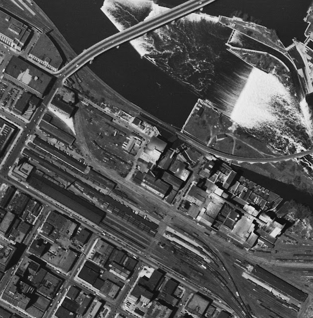
1947 aerial photo
[In the upper-left corner is part of the Union Station.]

Look at the hydraulic jump in the upper-left corner of this image. The reason why the milling industry started here was because of the waterpower provided by the St. Anthony Falls. The town already had a lot of sawmills.
mnhs.org/millcity

MillCity_learn
"Mill City Museum was built within the ruins of the Washburn A Mill, the flagship mill of the Washburn-Crosby Co. (later General Mills). It was the largest and most technologically advanced flour mill in the world when it was completed in 1880. Millers at the Washburn mills in the 1870s perfected a new process for milling, a revolution that made fine wheat flour available to the masses for the first time. Soon thereafter Minneapolis became the flour milling capital of the world, a title it held from 1880 to 1930."

MillCity_building, Source: MNHS Collections.
Washburn A Mill Complex at its peak. 
"Rail lines [e.g. M&StL] delivered grain from the vast western plains to the mill. St. Anthony Falls, which had long powered the sawmills of the lumber industry, began driving turbines for the flour mills, too. Trains traveling north to Duluth's port and east to the nation's major population centers carried the milled flour to market. An influx of immigrants provided the labor. It was a recipe for success"
 
Mill City History updated
1970 - Stone Arch Bridge. First off, these kids are being kind of naughty - this was an active railroad bridge, strictly off-limits. Note the skyline lacks tall buildings, the IDS Center won't be built for another 2 years. The Northwestern Bell Telephone Building (now Century Link Building) at 26 stories can be seen to the right of the City Hall Clock Tower. The Washburn A-Mill, to the right of the white silos, won't burn down for another 21 years. It's now home to the Mill City Museum. 

MillCity_history

"At the industry's peak, more than 20 stone flour mills stood along a covered canal, flowing with water drawn from the river above the falls. When the Washburn A Mill reopened in 1880, two years after the catastrophic explosion, it was the most technologically advanced and the largest in the world. At peak production, it ground enough flour to make 12 million loaves of bread in a day. This level of production was unheard of, as most mills at the time were still smaller operations serving the towns and cities in which they were located....The flour milling complex spawned a host of innovations in manufacturing and processing. The leaders of the Minneapolis milling industry, including the Washburn, Crosby, and Pillsbury families, invented equipment and techniques that both improved the quality of flour and increased production efficiencies. White flour, something once seen as a luxury for the rich, was brought to the masses. New flour-based products, such as cake mixes, created an entirely new market for flour....In 1930, Buffalo, New York, supplanted Minneapolis as the nation's flour-milling capital, producing 11 million barrels to Minneapolis's 10.8 million annually." [MillCity_milling]

Tuesday, August 22, 2023

Ishpeming, MI: C&NW Depot & Coaling Tower and Cliff's Shaft Mine Museum

Depot: (Satellite, Hematte Drive is over the footprint.)
Roundhouse: (Satellite, all traces of it are gone.)
Cliffs Shaft Mine Museum: (Satellite, 444 photos)

Mark Andersen posted
C&NW 1385 at Ishpeming, Michigan Depot. The date and photographer are unknown. Rescued from a dark moldy Anscochrome slide.
Caleb L. Gordon: Where exactly was this depot?
Barbara Lusardi: Caleb L. Gordon Where Hematite Drine is between 1st and 2nd street.
Andrew Roth: Great job cleaning up the slide!! The UP boxcar is on the DSS&A whose tracks were on the north side of the depot.
     : Nice. Rare color shot.
Peter Munro shared
Gary Baloun: Great historical picture. Glad 1385 survived.
Craig Nelsen: So, we can narrow the time down pretty good. 1954 Ford in picture on right side, Engine retired from service in summer of 1956...
Dennis DeBruler shared

Richard C. Burnes commented on Mark's post
Here's a postcard picture of the depot from 1912.

Mark Andersen commented on his post
Here's the original scan.

Dennis DeBruler commented on Barbara's comment
Thanks for the location.
1951 aerial photo
So the C&NW depot was north of their tracks. And it appears that the DSS&A had a bigger depot between Main and 1st.

Dennis DeBruler commented on Mark's post
1951 aerial photo
Was the roundhouse on the southwest side of town used by C&NW or DSS&A?

Dennis DeBruler commented on Mark's post
1951 aerial photo
According to a topo map, it does not look like C&NW hauled ore from this mine.
[The iron ore was hauled to a dock on Lake Superior.]

Street View, Sep 2022
 
CliffsShaftMineMuseum

Open pit mining was started in 1867. In 1877, shafts "A" and "B" were started to reach hard hematite ore that was found 400' deep. In 1919 the wooden shaft houses were replaced by the 97' high reinforced concrete structure. In 1954, the 174' tall Shaft "C" was opened and it replaced the other two shafts. The mine closed Dec 22, 1967. [CliffsShaftMineMuseum_history]

1952 Ishpeming Quad @ 24,000

Mike Patrick posted two photos with the comment: "9-65, I believe this is the C&NW facilities in Ishpeming MI. The roundhouse is on it's last legs and the coaling tower hasn't been used in almost a decade. I believe this facility is on borrowed time with the joint facility replacing it."
Ronald Kaminen: This is Ishpeming since you can see the Cliffs Shaft Mine in the back ground on the left side of the coal tower. There was also a water tank near the roundhouse but looks like it's gone too.!!
1

2